


![]()

zprávy
zdroje zpráv:vrchní referent/rada v oddělení právních vztahů k nemovitostem na Katastrálním pracovišti Kyjov
27.6.2024 14:03 ČÚZK /Urady/Katastralni-urady/Katastralni-urady/Katastralni-urad-pro-Jihomoravsky-kraj/Uredni-deska/Oznameni-a-jina-uredni-sdeleni/Volna-mista/DMS/vrchni-referent-rada-v-oddeleni-pravnich-vztahu-k-vrchní referent/rada v oddělení právních vztahů k nemovitostem na Katastrálním pracovišti Kyjov
27.6.2024 14:03 ČÚZK - volná místa Katastrální úřad pro Jihomoravský kraj Katastrální pracoviště Kyjov vypisuje výběrové řízení na místo vrchní referent/rada v oddělení právních vztahů k nemovitostem na Katastrálním pracovišti Kyjovodborný referent/vrchní referent v oddělení aktualizace KN na Katastrálním pracovišti Hodonín
27.6.2024 13:58 ČÚZK - předpisy a opatření Katastrální úřad pro Jihomoravský kraj Katastrální pracoviště Hodonínvypisuje výběrové řízení na místo
odborný referent/vrchní referent v oddělení aktualizace KN na Katastrálním pracovišti Hodonín
odborný referent/vrchní referent v oddělení aktualizace KN na Katastrálním pracovišti Hodonín
27.6.2024 13:58 ČÚZK - volná místa Katastrální úřad pro Jihomoravský kraj Katastrální pracoviště Hodonín vypisuje výběrové řízení na místo odborný referent/vrchní referent v oddělení aktualizace KN na Katastrálním pracovišti Hodonínodborný referent/vrchní referent v oddělení aktualizace KN na Katastrálním pracovišti Hodonín
27.6.2024 13:58 ČÚZK /Urady/Katastralni-urady/Katastralni-urady/Katastralni-urad-pro-Jihomoravsky-kraj/Uredni-deska/Oznameni-a-jina-uredni-sdeleni/Volna-mista/DMS/odborny-referent-vrchni-referent-v-oddeleni-aktualZahájení revize katastru nemovitostí od 1. 9. 2024
27.6.2024 12:22 ČÚZK /Urady/Katastralni-urady/Katastralni-urady/Katastralni-urad-pro-Liberecky-kraj/Katastralni-pracoviste/KP-Ceska-Lipa/O-uradu/Aktuality/Zahajeni-revize-katastru-nemovitosti-od-1-9-2024Zahájení revize katastru nemovitostí od 1. 9. 2024
27.6.2024 12:22 ČÚZK - předpisy a opatření Katastrální úřad pro Liberecký kraj - Katastrální pracoviště Česká Lípa zveřejnil novou aktualitu: Katastrální úřad pro Liberecký kraj, Katastrální pracoviště Česká Lípa oznamuje, že dnem 2. 9. 2024 bude zahájena revize katastru nemovitostí v k. ú. Dubice u České Lípy, Heřmaničky u Dobranova, Písečná u Dobranova, Stará Lípa (vše město Česká Lípa) a dále v k. ú. Srní u České Lípy (obec Provodín) a k. ú. Stráž u České Lípy (obec Stružnice). Podrobnosti viz úřední deska.Zahájení revize katastru nemovitostí od 1. 9. 2024
27.6.2024 12:22 ČÚZK - předpisy a opatření Katastrální úřad pro Liberecký kraj - Katastrální pracoviště Česká Lípa zveřejnil novou aktualitu:Krátka správa č. 28/2024
27.6.2024 11:26 Komora geodetů a kartografů SRThe post Krátka správa č. 28/2024 appeared first on Komora geodetov a kartografov.
Krátka správa č. 27/2024
27.6.2024 11:22 Komora geodetů a kartografů SRThe post Krátka správa č. 27/2024 appeared first on Komora geodetov a kartografov.
20240627-VŘ Administrace UNIX
27.6.2024 11:12 ČÚZK - aktuality v resortu Oznámení o vyhlášení výběrového řízení na obsazení služebního místa rada/odborný rada - Administrace UNIX.20240627-VŘ Administrace UNIX
27.6.2024 11:12 ČÚZK /Aktuality-resort/2024/20240627-VR-Administrace-UNIX20240627-VŘ Administrace UNIX
27.6.2024 11:12 ČÚZK - předpisy a opatření Český úřad zeměměřický a katastrální zveřejnil novou aktualitu: Oznámení o vyhlášení výběrového řízení na obsazení služebního místa rada/odborný rada - Administrace UNIX.Výběrové řízení na KÚ pro Vysočinu
27.6.2024 9:45 ČÚZK - předpisy a opatření Katastrální úřad pro Vysočinu zveřejnil novou aktualitu: Oznámení o vyhlášení výběrového řízení na služební místo rada/odborný rada – oddělení obnovy katastrálního operátu I Technického odboru na Katastrálním úřadu pro Vysočinu.Výběrové řízení na KP Pelhřimov
27.6.2024 9:44 ČÚZK - předpisy a opatření Katastrální úřad pro Vysočinu - Katastrální pracoviště Pelhřimov zveřejnil novou aktualitu: Oznámení o vyhlášení výběrového řízení na služební místo odborný referent/vrchní referent – oddělení aktualizace KN Katastrálního pracoviště Pelhřimov.Výběrové řízení na KP Pelhřimov
27.6.2024 9:44 ČÚZK /Urady/Katastralni-urady/Katastralni-urady/Katastralni-urad-pro-Vysocinu/O-uradu/Aktuality/Vyberove-rizeni-na-KP-Pelhrimov-(1)Nedostupnost WSDP na zkoušku ve dnech 28.6. 2024 - 3.7.2024
27.6.2024 9:26 ČÚZK - předpisy a opatření Vážení uživatelé webových služeb,oznamujeme, že z technických důvodů nebudou ve dnech od 28.6.2024 od 12:00 do 3.7.2024 dostupné webové služby dálkového přístupu na zkoušku.
Za komplikace se omlouváme a děkujeme za pochopení.
Nedostupnost WSDP na zkoušku ve dnech 28.6. 2024 - 3.7.2024
27.6.2024 9:26 Dálkový přístup k údajům KN ČR Vážení uživatelé webových služeb,oznamujeme, že z technických důvodů nebudou ve dnech od 28.6.2024 od 12:00 do 3.7.2024 dostupné webové služby dálkového přístupu na zkoušku.
Za komplikace se omlouváme a děkujeme za pochopení.
Nedostupnost WSDP na zkoušku ve dnech 28.6. 2024 - 3.7.2024
27.6.2024 9:26 ČÚZK /Aplikace-DP-do-KN/Aplikace-DP-do-KN/Archiv-DP/418691odborný/vrchní referent - aktualizace KN KP Pelhřimov
27.6.2024 9:08 ČÚZK - předpisy a opatření Katastrální úřad pro Vysočinu Katastrální pracoviště Pelhřimovvypisuje výběrové řízení na místo
odborný/vrchní referent - aktualizace KN KP Pelhřimov
odborný/vrchní referent - aktualizace KN KP Pelhřimov
27.6.2024 9:08 ČÚZK /Urady/Katastralni-urady/Katastralni-urady/Katastralni-urad-pro-Vysocinu/Uredni-deska/Oznameni-a-jina-uredni-sdeleni/Volna-mista/DMS/odborny-vrchni-referent-aktualizace-KN-KP-Pelhrimoodborný/vrchní referent - aktualizace KN KP Pelhřimov
27.6.2024 9:08 ČÚZK - volná místa Katastrální úřad pro Vysočinu Katastrální pracoviště Pelhřimov vypisuje výběrové řízení na místo odborný/vrchní referent - aktualizace KN KP PelhřimovA first: EarthCARE reveals inner secrets of clouds
27.6.2024 9:00 ESA Observing the Earth
Less than a month after it was launched, ESA’s EarthCARE satellite has returned the first image from one of its instruments – an image that, for the first time from space, unveils the internal structure and dynamics of clouds.
This remarkable first image, captured by the satellite’s cloud profiling radar, offers a mere glimpse of the instrument's full potential once it is fully calibrated.
rada-odborný rada - obnova KO I Technický odbor
27.6.2024 8:39 ČÚZK /Urady/Katastralni-urady/Katastralni-urady/Katastralni-urad-pro-Vysocinu/Uredni-deska/Oznameni-a-jina-uredni-sdeleni/Volna-mista/DMS/rada-odborny-rada-obnova-KO-I-Technicky-odborrada-odborný rada - obnova KO I Technický odbor
27.6.2024 8:39 ČÚZK - volná místa Katastrální úřad pro Vysočinu technický odbor vypisuje výběrové řízení na místo rada-odborný rada - obnova KO I Technický odborrada-odborný rada - obnova KO I Technický odbor
27.6.2024 8:39 ČÚZK - předpisy a opatření Katastrální úřad pro Vysočinu technický odborvypisuje výběrové řízení na místo
rada-odborný rada - obnova KO I Technický odbor
Mapy jsou pro každého 2024 (1. cirkulář)
27.6.2024 8:36 GISportal.cz
Michal Souček a Drahomíra Zedníčková Vás srdečně zvou na desátý ročník odborné konference Mapy jsou pro každého. Tento rok slaví dekádu sdílení vášně pro geografické informační systémy a objevování, jak mapy formují náš svět a pomáhají nám lépe porozumět jeho dynamice. Proč byste měli přijít? Zajímavé prezentace a příspěvky: Naše konference je plná inspirujících prezentací […]
The post Mapy jsou pro každého 2024 (1. cirkulář) appeared first on GISportal.cz.
Mapy jsou pro každého 2024 (1. cirkulář)
27.6.2024 8:36 GISportal.czMichal Souček a Drahomíra Zedníčková Vás srdečně zvou na desátý ročník odborné konference Mapy jsou pro každého. Tento rok slaví dekádu sdílení vášně pro geografické informační systémy a objevování, jak mapy formují náš svět a pomáhají nám lépe porozumět jeho dynamice. Proč byste měli přijít? Zajímavé prezentace a příspěvky: Naše konference je plná inspirujících prezentací […]
The post Mapy jsou pro každého 2024 (1. cirkulář) appeared first on GISportal.cz.
výpočetní technika
27.6.2024 8:31 ČÚZK /Urady/Katastralni-urady/Katastralni-urady/Katastralni-urad-pro-Vysocinu/Nabidky-majetku/vypocetni-technika-(1)výpočetní technika
27.6.2024 8:31 ČÚZK - předpisy a opatřeníKatastrální úřad pro Vysočinu - Katastrální pracoviště Moravské Budějovice nabízí nepotřebný majetek k odkupu. Jedná se o
výpočetní technika
18. jednání TPS
26.6.2024 18:04 ČÚZK - předpisy a opatření Dne 21. srpna 2024 proběhne distančně 18. jednání Technické pracovní skupiny Koordinační rady správců DMVS a DTM.40. jednání KRS DMVS/DTM
26.6.2024 18:02 ČÚZK - předpisy a opatření Dne 24. července 2024 proběhne distančně 40. jednání Koordinační rady správců DMVS a DTM.Zveřejnění obsahu informací poskytnutých na žádost dle zákona č. 106/1999 Sb. za rok 20
26.6.2024 16:49 ČÚZK - předpisy a opatření Katastrální úřad pro hlavní město Prahuzveřejňuje obsah informace poskytnutých na žádost dle zákona č. 106/1999 Sb. za rok
2024
Zveřejnění obsahu informací poskytnutých na žádost dle zákona č. 106/1999 Sb. za rok 20
26.6.2024 16:49 ČÚZK /Urady/Katastralni-urady/Katastralni-urady/Katastralni-urad-pro-hlavni-mesto-Prahu/Casto-hledane-informace/Poskytovani-informaci-106-1999-Sb/Zverejneni-obsahu-informaci-poskytnutych-na-za-(1)/Zverejneni-obsahu-informaci-poskytnutych-na-za-(6)Zveřejnění obsahu informací poskytnutých na žádost dle zákona č. 106/1999 Sb. za rok 20
26.6.2024 16:49 ČÚZK - předpisy a opatření Katastrální úřad pro hlavní město Prahuzveřejňuje obsah informace poskytnutých na žádost dle zákona č. 106/1999 Sb. za rok
2024
Zveřejnění obsahu informací poskytnutých na žádost dle zákona č. 106/1999 Sb. za rok 20
26.6.2024 16:49 ČÚZK /Urady/Katastralni-urady/Katastralni-urady/Katastralni-urad-pro-hlavni-mesto-Prahu/Casto-hledane-informace/Poskytovani-informaci-106-1999-Sb/Zverejneni-obsahu-informaci-poskytnutych-na-za-(1)/Zverejneni-obsahu-informaci-poskytnutych-na-za-(6)TurboCAD Platinum + TurboPDF v akční ceně
26.6.2024 15:40 ŠPINAR - softwareVážení zákazníci,
dovolujeme si Vám nabídnout programy TurboCAD Platinum 28 + TurboPDF, které spojují CAD nástroje pro kreslení ve 2D / 3D prostoru včetně fotorealistických výstupů s editorem a převodníkem PDF dokumentů v akční ceně..
The post TurboCAD Platinum + TurboPDF v akční ceně appeared first on ŠPINAR – software.
Outcomes of the Board, International Council and Chapter Conference, and Asia Summit 2024
26.6.2024 14:12 buildingSMART.orgLondon, U.K. – June 26th, 2024 – The buildingSMART International (bSI) Board, International Council and Chapter Conference took place between 18-21 June 2024 in Hong Kong, with a variety of…
The post Outcomes of the Board, International Council and Chapter Conference, and Asia Summit 2024 appeared first on buildingSMART International.
Outcomes of the Board, International Council and Chapter Conference, and Asia Summit 2024
26.6.2024 14:12 buildingSMART.orgLondon, (June 4, 2024) – buildingSMART International is pleased to announce that Information Delivery Specification (IDS) v1.0 has reached final standard status. This approval marks a significant milestone in how…
The post Outcomes of the Board, International Council and Chapter Conference, and Asia Summit 2024 appeared first on buildingSMART International.
Outcomes of the Board, International Council and Chapter Conference, and Asia Summit 2024
26.6.2024 14:12 buildingSMART.orgLondon, U.K. – June 27th, 2024 – The buildingSMART International (bSI) Board, International Council and Chapter Conference took place between 18-21 June 2024 in Hong Kong, with a variety of…
The post Outcomes of the Board, International Council and Chapter Conference, and Asia Summit 2024 appeared first on buildingSMART International.
vrchní referent/rada – obnova katastrálního operátu v oddělení obnovy a revize KN Katastrálního prac
26.6.2024 13:43 ČÚZK - předpisy a opatření Katastrální úřad pro Jihočeský kraj Katastrální pracoviště České Budějovicevypisuje výběrové řízení na místo
vrchní referent/rada – obnova katastrálního operátu v oddělení obnovy a revize KN Katastrálního pracoviště České Budějovice
vrchní referent/rada – obnova katastrálního operátu v oddělení obnovy a revize KN Katastrálního prac
26.6.2024 13:43 ČÚZK /Urady/Katastralni-urady/Katastralni-urady/Katastralni-urad-pro-Jihocesky-kraj/Uredni-deska/Oznameni-a-jina-uredni-sdeleni/Volna-mista/DMS/vrchni-referent-rada-–-obnova-katastralniho-operatvrchní referent/rada – obnova katastrálního operátu v oddělení obnovy a revize KN Katastrálního prac
26.6.2024 13:43 ČÚZK - volná místa Katastrální úřad pro Jihočeský kraj Katastrální pracoviště České Budějovice vypisuje výběrové řízení na místo vrchní referent/rada – obnova katastrálního operátu v oddělení obnovy a revize KN Katastrálního pracStartují digitální technické mapy krajů. Obcím ulehčí plánování i administrativu (TZ)
26.6.2024 9:36 GISportal.cz
Od 1. července letošního roku vznikají obcím nové povinnosti v souvislosti s projektem krajských digitálních technických map. Města a vesnice musejí v rámci nich povinně aktualizovat data o svém polohopisu a dopravní a technické infrastruktuře. V tuto chvíli by tak již radnice měly mít jasno, zda svoji editorskou činnost zajistí samy, nebo ji svěří externímu dodavateli. „Nerespektovat zákonnou povinnost se nemusí […]
The post Startují digitální technické mapy krajů. Obcím ulehčí plánování i administrativu (TZ) appeared first on GISportal.cz.
Startují digitální technické mapy krajů. Obcím ulehčí plánování i administrativu (TZ)
26.6.2024 9:36 GISportal.czOd 1. července letošního roku vznikají obcím nové povinnosti v souvislosti s projektem krajských digitálních technických map. Města a vesnice musejí v rámci nich povinně aktualizovat data o svém polohopisu a dopravní a technické infrastruktuře. V tuto chvíli by tak již radnice měly mít jasno, zda svoji editorskou činnost zajistí samy, nebo ji svěří externímu dodavateli. „Nerespektovat zákonnou povinnost se nemusí […]
The post Startují digitální technické mapy krajů. Obcím ulehčí plánování i administrativu (TZ) appeared first on GISportal.cz.
Konec podávání přihlášek v druhém kole přijímacího řízení
26.6.2024 9:19 Katedra geoinformatiky UP OlomoucBlíží se konec podávání přihlášek v druhém kole přijímacího řízení! Termín je stanoven na 14. 7. 2024, takže neváhejte a využijte příležitosti přihlásit se ke studiu na olomoucké geoinformatice! Naši první přijatí studenti se už sešli na katedře během akce Na den geoinformatikem, aby si prohlédli svou budoucí školu. Přidejte se k nim a podejte […]
The post Konec podávání přihlášek v druhém kole přijímacího řízení first appeared on Katedra geoinformatiky.
Nabídka práce ve Zlíně
26.6.2024 8:48 Katedra geoinformatiky UP OlomoucJsme Kancelář architekta města Zlína a hledáme geoinformatika, který by doplnil náš dvoučlenný ArcGIS tým a to především o znalosti v oblasti programování ( Arcade, Python..). Nabízená práce je na částečný úvazek, na dva roky, v rámci projektu mezinárodní spolupráce. Preferujeme nástup v září (případně v říjnu) 2024. Částečný home office je možný. Zaměstnavatelem je […]
The post Nabídka práce ve Zlíně first appeared on Katedra geoinformatiky.
Výběrové řízení na KP Pelhřimov
25.6.2024 10:13 ČÚZK - předpisy a opatření Katastrální úřad pro Vysočinu - Katastrální pracoviště Pelhřimov zveřejnil novou aktualitu: Oznámení o vyhlášení výběrového řízení na služební místo rada/odborný rada – oddělení aktualizace KN Katastrálního pracoviště Pelhřimov.rada-odborný rada -oddělení aktualizace KN KP Pelhřimov
25.6.2024 9:05 ČÚZK - předpisy a opatření Katastrální úřad pro Vysočinu Katastrální pracoviště Pelhřimovvypisuje výběrové řízení na místo
rada-odborný rada -oddělení aktualizace KN KP Pelhřimov
rada-odborný rada -oddělení aktualizace KN KP Pelhřimov
25.6.2024 9:05 ČÚZK - volná místa Katastrální úřad pro Vysočinu Katastrální pracoviště Pelhřimov vypisuje výběrové řízení na místo rada-odborný rada -oddělení aktualizace KN KP Pelhřimovrada-odborný rada -oddělení aktualizace KN KP Pelhřimov
25.6.2024 9:05 ČÚZK /Urady/Katastralni-urady/Katastralni-urady/Katastralni-urad-pro-Vysocinu/Uredni-deska/Oznameni-a-jina-uredni-sdeleni/Volna-mista/DMS/rada-odborny-rada-oddeleni-aktualizace-KN-KP-PelhrUpozornění pro uživatele poskytující ověřené výstupy, zejména pro notáře.
24.6.2024 19:41 Dálkový přístup k údajům KN ČR Vážení uživatelé, provádějící vydávání ověřených výstupů z katastru nemovitostí,upozorňujeme, že dne 1.7.2024 nabyde účinnosti vyhláška č. 50/2024 Sb., kterou se mění vyhláška č. 358/2013 Sb., o poskytování údajů z katastru nemovitostí, ve znění vyhlášek č. 354/2015 Sb. a č. 256/2018 Sb. (https://www.e-sbirka.cz/sb/2024/50). Novela upravuje úplatu za vydání ověřených výstupů z katastru nemovitostí:
- Výpis z katastru – od 1.7.2024 úplata bude činit 50 Kč (do 30.6.2024 činí úplata 50 Kč) – NEDOCHÁZÍ KE ZMĚNĚ,
- Evidence práv pro osobu – od 1.7.2024 úplata bude činit 75 Kč (do 30.6.2024 činí úplata 50 Kč),
- Ověřený výstup nebo duplikát listiny ze sbírky listin katastru – od 1.7.2024 úplata bude činit 10 Kč (do 30.6.2024 činí úplata 10 Kč) – NEDOCHÁZÍ KE ZMĚNĚ,
- Přehled vlastnictví s nemovitostmi – od 1.7.2024 úplata bude činit 100 Kč.
Upozornění pro uživatele poskytující ověřené výstupy zejména pro notáře.
24.6.2024 19:41 ČÚZK /Aplikace-DP-do-KN/Aplikace-DP-do-KN/Archiv-DP/418439Upozornění pro uživatele poskytující ověřené výstupy zejména pro notáře.
24.6.2024 19:41 Dálkový přístup k údajům KN ČR Vážení uživatelé, provádějící vydávání ověřených výstupů z katastru nemovitostí,upozorňujeme, že dne 1.7.2024 nabyde účinnosti vyhláška č. 50/2024 Sb., kterou se mění vyhláška č. 358/2013 Sb., o poskytování údajů z katastru nemovitostí, ve znění vyhlášek č. 354/2015 Sb. a č. 256/2018 Sb. (https://www.e-sbirka.cz/sb/2024/50). Novela upravuje úplatu za vydání ověřených výstupů z katastru nemovitostí:
- Výpis z katastru – od 1.7.2024 úplata bude činit 50 Kč (do 30.6.2024 činí úplata 50 Kč),
- Evidence práv pro osobu – od 1.7.2024 úplata bude činit 75 Kč (do 30.6.2024 činí úplata 50 Kč),
- Ověřený výstup nebo duplikát listiny ze sbírky listin katastru – od 1.7.2024 úplata bude činit 20 Kč (do 30.6.2024 činí úplata 10 Kč).
- Přehled vlastnictví s nemovitostmi – od 1.7.2024 úplata bude činit 100 Kč.
Upozornění pro uživatele poskytující ověřené výstupy, zejména pro notáře.
24.6.2024 19:41 Dálkový přístup k údajům KN ČR Vážení uživatelé, provádějící vydávání ověřených výstupů z katastru nemovitostí,upozorňujeme, že dne 1.7.2024 nabyde účinnosti vyhláška č. 50/2024 Sb., kterou se mění vyhláška č. 358/2013 Sb., o poskytování údajů z katastru nemovitostí, ve znění vyhlášek č. 354/2015 Sb. a č. 256/2018 Sb. (https://www.e-sbirka.cz/sb/2024/50). Novela upravuje úplatu za vydání ověřených výstupů z katastru nemovitostí:
- Výpis z katastru – od 1.7.2024 úplata bude činit 50 Kč (do 30.6.2024 činí úplata 50 Kč) – NEDOCHÁZÍ KE ZMĚNĚ,
- Evidence práv pro osobu – od 1.7.2024 úplata bude činit 75 Kč (do 30.6.2024 činí úplata 50 Kč),
- Ověřený výstup nebo duplikát listiny ze sbírky listin katastru – od 1.7.2024 úplata bude činit 10 Kč (do 30.6.2024 činí úplata 10 Kč) – NEDOCHÁZÍ KE ZMĚNĚ,
- Přehled vlastnictví s nemovitostmi – od 1.7.2024 úplata bude činit 100 Kč.
Upozornění pro uživatele poskytující ověřené výstupy zejména pro notáře.
24.6.2024 19:41 ČÚZK - předpisy a opatření Vážení uživatelé, provádějící vydávání ověřených výstupů z katastru nemovitostí,upozorňujeme, že dne 1.7.2024 nabyde účinnosti vyhláška č. 50/2024 Sb., kterou se mění vyhláška č. 358/2013 Sb., o poskytování údajů z katastru nemovitostí, ve znění vyhlášek č. 354/2015 Sb. a č. 256/2018 Sb. (https://www.e-sbirka.cz/sb/2024/50). Novela upravuje úplatu za vydání ověřených výstupů z katastru nemovitostí:
- Výpis z katastru – od 1.7.2024 úplata bude činit 50 Kč (do 30.6.2024 činí úplata 50 Kč),
- Evidence práv pro osobu – od 1.7.2024 úplata bude činit 75 Kč (do 30.6.2024 činí úplata 50 Kč),
- Ověřený výstup nebo duplikát listiny ze sbírky listin katastru – od 1.7.2024 úplata bude činit 20 Kč (do 30.6.2024 činí úplata 10 Kč).
- Přehled vlastnictví s nemovitostmi – od 1.7.2024 úplata bude činit 100 Kč.
Upozornění pro uživatele poskytující ověřené výstupy, zejména pro notáře.
24.6.2024 19:41 ČÚZK - předpisy a opatření Vážení uživatelé, provádějící vydávání ověřených výstupů z katastru nemovitostí,upozorňujeme, že dne 1.7.2024 nabyde účinnosti vyhláška č. 50/2024 Sb., kterou se mění vyhláška č. 358/2013 Sb., o poskytování údajů z katastru nemovitostí, ve znění vyhlášek č. 354/2015 Sb. a č. 256/2018 Sb. (https://www.e-sbirka.cz/sb/2024/50). Novela upravuje úplatu za vydání ověřených výstupů z katastru nemovitostí:
- Výpis z katastru – od 1.7.2024 úplata bude činit 50 Kč (do 30.6.2024 činí úplata 50 Kč) – NEDOCHÁZÍ KE ZMĚNĚ,
- Evidence práv pro osobu – od 1.7.2024 úplata bude činit 75 Kč (do 30.6.2024 činí úplata 50 Kč),
- Ověřený výstup nebo duplikát listiny ze sbírky listin katastru – od 1.7.2024 úplata bude činit 10 Kč (do 30.6.2024 činí úplata 10 Kč) – NEDOCHÁZÍ KE ZMĚNĚ,
- Přehled vlastnictví s nemovitostmi – od 1.7.2024 úplata bude činit 100 Kč.
Upozornění pro uživatele poskytující ověřené výstupy, zejména pro notáře.
24.6.2024 19:41 ČÚZK /Aplikace-DP-do-KN/Aplikace-DP-do-KN/Archiv-DP/418439odborný referent/vrchní referent – poskytování informací a nahlížení do KN
24.6.2024 16:48 ČÚZK - předpisy a opatření Katastrální úřad pro hlavní město Prahu zveřejnil novou aktualitu: Ředitelka úřadu vyhlašuje výběrové řízení na pozici:odborný referent/vrchní referent – poskytování informací a nahlížení do KN
odborný referent/vrchní referent – poskytování informací a nahlížení do KN
24.6.2024 16:44 ČÚZK - předpisy a opatření Katastrální úřad pro hlavní město Prahuvypisuje výběrové řízení na místo
odborný referent/vrchní referent – poskytování informací a nahlížení do KN
odborný referent/vrchní referent – poskytování informací a nahlížení do KN
24.6.2024 16:44 ČÚZK - volná místa Katastrální úřad pro hlavní město Prahu vypisuje výběrové řízení na místo odborný referent/vrchní referent – poskytování informací a nahlížení do KNodborný referent/vrchní referent – poskytování informací a nahlížení do KN
24.6.2024 16:44 ČÚZK /Urady/Katastralni-urady/Katastralni-urady/Katastralni-urad-pro-hlavni-mesto-Prahu/Uredni-deska/Oznameni-a-jina-uredni-sdeleni/Volna-mista/odborny-referent-vrchni-referent-–-poskytovani-infrada/ odborný rada – návrh zápisu, kontrola a zplatnění
24.6.2024 16:42 ČÚZK - předpisy a opatření Katastrální úřad pro hlavní město Prahu zveřejnil novou aktualitu: Ředitelka úřadu vyhlašuje výběrové řízení na pozici:rada/ odborný rada – návrh zápisu, kontrola a zplatnění
rada/ odborný rada – návrh zápisu, kontrola a zplatnění
24.6.2024 16:40 ČÚZK /Urady/Katastralni-urady/Katastralni-urady/Katastralni-urad-pro-hlavni-mesto-Prahu/Uredni-deska/Oznameni-a-jina-uredni-sdeleni/Volna-mista/rada-odborny-rada-–-navrh-zapisu,-kontrola-a-zplatrada/ odborný rada – návrh zápisu, kontrola a zplatnění
24.6.2024 16:40 ČÚZK - volná místa Katastrální úřad pro hlavní město Prahu vypisuje výběrové řízení na místo rada/ odborný rada – návrh zápisu, kontrola a zplatněnírada/ odborný rada – návrh zápisu, kontrola a zplatnění
24.6.2024 16:40 ČÚZK - předpisy a opatření Katastrální úřad pro hlavní město Prahuvypisuje výběrové řízení na místo
rada/ odborný rada – návrh zápisu, kontrola a zplatnění
rada / odborný rada v oddělení právních vztahů k nemovitostem Katastrálního pracoviště Hradec Králov
24.6.2024 14:27 ČÚZK - volná místa Katastrální úřad pro Královéhradecký kraj Katastrální pracoviště Hradec Králové vypisuje výběrové řízení na místo rada / odborný rada v oddělení právních vztahů k nemovitostem Katastrálního pracoviště Hradec Královrada / odborný rada v oddělení právních vztahů k nemovitostem Katastrálního pracoviště Hradec Králov
24.6.2024 14:27 ČÚZK - předpisy a opatření Katastrální úřad pro Královéhradecký kraj Katastrální pracoviště Hradec Královévypisuje výběrové řízení na místo
rada / odborný rada v oddělení právních vztahů k nemovitostem Katastrálního pracoviště Hradec Králové
odborný rada – kontrolor
24.6.2024 13:19 ČÚZK /Urady/Katastralni-urady/Katastralni-urady/Katastralni-urad-pro-hlavni-mesto-Prahu/O-uradu/Aktuality/odborny-rada-–-kontrolorodborný rada – kontrolor
24.6.2024 13:19 ČÚZK - předpisy a opatření Katastrální úřad pro hlavní město Prahu zveřejnil novou aktualitu: Ředitelka úřadu vyhlašuje výběrové řízení na pozici:odborný rada – kontrolor
odborný rada – kontrolor
24.6.2024 13:18 ČÚZK /Urady/Katastralni-urady/Katastralni-urady/Katastralni-urad-pro-hlavni-mesto-Prahu/Uredni-deska/Oznameni-a-jina-uredni-sdeleni/Volna-mista/odborny-rada-–-kontrolorodborný rada – kontrolor
24.6.2024 13:18 ČÚZK - volná místa Katastrální úřad pro hlavní město Prahu vypisuje výběrové řízení na místo odborný rada – kontrolorodborný rada – kontrolor
24.6.2024 13:18 ČÚZK - předpisy a opatření Katastrální úřad pro hlavní město Prahuvypisuje výběrové řízení na místo
odborný rada – kontrolor
Řady českých kartografů opustil její čestný člen profesor Erhart Srnka
24.6.2024 9:10 Česká kartografická společnostPo krátké nemoci zemřel ve středu 19. června 2024 ve věku nedožitých 98 let čestný člen České kartografické společnosti Prof. Ing. Erhart Srnka, DrSc. Poslední rozloučení se bude konat ve středu 26. června 2024 ve 14.00 hodin v obřadní síni krematoria města Brna, Jihlavská 1.
The post Řady českých kartografů opustil její čestný člen profesor Erhart Srnka first appeared on Česká kartografická společnost.
Save the date: ESA’s Living Planet Symposium 2025
24.6.2024 8:35 ESA Observing the Earth
Save the date for ESA’s next Living Planet Symposium, set for 23–27 June 2025 at the Austria Center Vienna. Held every three years, this premier Earth observation conference continues to expand in both size and scope. With the climate crisis intensifying, this event emphasises transitioning from ‘observation to climate action and sustainability for Earth’. Don't miss it!
Technické problémy hlasových služeb
24.6.2024 8:31 ČÚZK - předpisy a opatření Katastrální úřad pro Ústecký kraj - Katastrální pracoviště Litoměřicezveřejnil novou aktualitu: Na katastrálním pracovišti Litoměřice je hlášena technická porucha hlasových služeb. Ke kontaktu prosím využijte například e-mail: kp.litomerice@cuzk.cz.
Technické problémy hlasových služeb
24.6.2024 8:31 ČÚZK /Urady/Katastralni-urady/Katastralni-urady/Katastralni-urad-pro-Ustecky-kraj/Katastralni-pracoviste/KP-Litomerice/O-uradu/Aktuality/Technicke-problemy-hlasovych-sluzebTurboCAD Deluxe + TurboPDF v akční ceně
22.6.2024 7:04 ŠPINAR - softwareVážení zákazníci,
dovolujeme si Vám nabídnout programy TurboCAD Deluxe 28 + TurboPDF, které spojují CAD nástroje pro kreslení ve 2D / 3D prostoru včetně fotorealistických výstupů s editorem a převodníkem PDF dokumentů v akční ceně do 09. 07. 2023.
Saharan dust over the Strait of Messina
21.6.2024 14:18 ESA Observing the Earth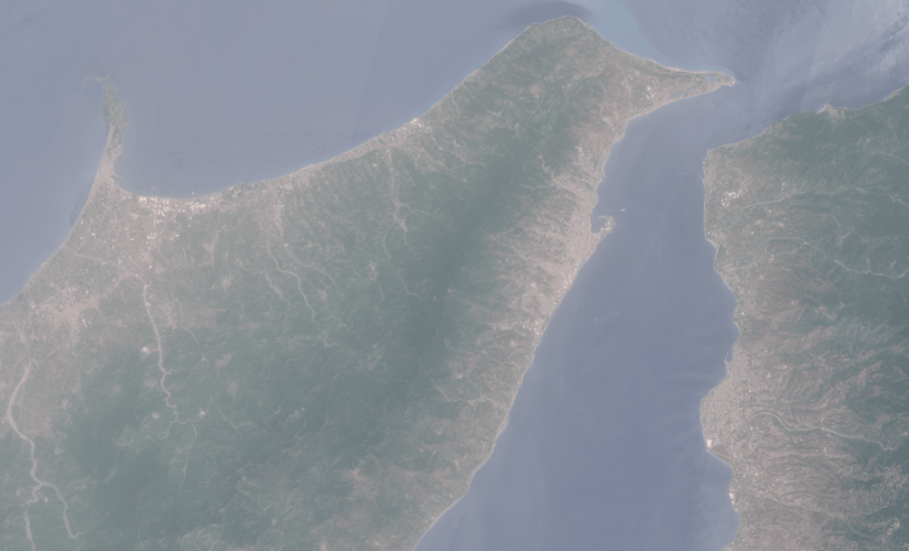 Image:
Saharan dust over the Strait of Messina
Image:
Saharan dust over the Strait of Messina
20240621_Rada / odborný rada oddělení aktualizace KN
21.6.2024 11:53 ČÚZK /Urady/Katastralni-urady/Katastralni-urady/Katastralni-urad-pro-Stredocesky-kraj/Katastralni-pracoviste/KP-Benesov/O-uradu/Aktuality/20240621_Rada-odborny-rada-oddeleni-aktualizace-KN20240621_Rada / odborný rada oddělení aktualizace KN
21.6.2024 11:53 ČÚZK - předpisy a opatření Katastrální úřad pro Středočeský kraj - Katastrální pracoviště Benešov Vyhlášení výběrového řízení: Rada / odborný rada oddělení aktualizace KN V části "Úřední deska", v sekci "Oznámení a jiná úřední sdělení" bylo vystaveno "Oznámení o vyhlášení výběrového řízení na obsazení služebního místa Rada / odborný rada oddělení aktualizace KN"Rada / odborný rada oddělení aktualizace KN
21.6.2024 11:51 ČÚZK - předpisy a opatření Katastrální úřad pro Středočeský kraj Katastrální pracoviště Benešovvypisuje výběrové řízení na místo
Rada / odborný rada oddělení aktualizace KN
Rada / odborný rada oddělení aktualizace KN
21.6.2024 11:51 ČÚZK - volná místa Katastrální úřad pro Středočeský kraj Katastrální pracoviště Benešov vypisuje výběrové řízení na místo Rada / odborný rada oddělení aktualizace KN20240621_Odborný referent oddělení aktualizace KN
21.6.2024 11:44 ČÚZK - předpisy a opatření Katastrální úřad pro Středočeský kraj - Katastrální pracoviště Benešov Vyhlášení výběrového řízení: Odborný referent oddělení aktualizace KN V části "Úřední deska", v sekci "Oznámení a jiná úřední sdělení" bylo vystaveno "Oznámení o vyhlášení výběrového řízení na obsazení služebního místa Odborný referent oddělení aktualizace KN"20240621_Odborný referent oddělení aktualizace KN
21.6.2024 11:44 ČÚZK /Urady/Katastralni-urady/Katastralni-urady/Katastralni-urad-pro-Stredocesky-kraj/Katastralni-pracoviste/KP-Benesov/O-uradu/Aktuality/20240621_Odborny-referent-oddeleni-aktualizace-KNEarth from Space: Adam’s Bridge
21.6.2024 10:00 ESA Observing the Earth Image:
This Copernicus Sentinel-2 image shows Adam’s Bridge, a chain of shoals linking India and Sri Lanka.
Image:
This Copernicus Sentinel-2 image shows Adam’s Bridge, a chain of shoals linking India and Sri Lanka.
České uživatelské fórum Copernicus a Dálkový průzkum Země (save the date)
21.6.2024 9:13 GISportal.cz
The post České uživatelské fórum Copernicus a Dálkový průzkum Země (save the date) appeared first on GISportal.cz.
Summer solstice 2024
20.6.2024 16:15 ESA Observing the Earth Video:
00:00:10
Video:
00:00:10
Summer officially begins in the Northern Hemisphere today 20 June, marking the longest day of the year. The summer solstice, which is when the Sun reaches the most northerly point in the sky, is set to occur tonight at 21:50 BST/22:50 CEST.
During the summer solstice, the Northern Hemisphere will experience the longest period of sunlight in a day or the longest day of the year. This is because of Earth’s position in orbit around the Sun and the way the North Pole is tilted towards the Sun during the solstice.
The Sun’s rays hit the Northern Hemisphere at their most direct angle, resulting in the most extended period of daylight. Despite the long hours of daylight, it may not necessarily be the hottest day of the year.
This animation shows one image per day captured by the Meteosat Second Generation from 20 June 2023 until 19 June 2024 captured at approximately 16:30 BST/17:30 CEST.
Summer solstice 2024
20.6.2024 15:00 ESA Observing the Earth
Video:
00:00:10
Summer officially begins in the Northern Hemisphere today 20 June, marking the longest day of the year. The summer solstice, which is when the Sun reaches the most northerly point in the sky, is set to occur tonight at 22:50 CEST.
During the summer solstice, the Northern Hemisphere will experience the longest period of sunlight in a day or the longest day of the year. This is because of Earth’s position in orbit around the Sun and the way the North Pole is tilted towards the Sun during the solstice.
The Sun’s rays hit the Northern Hemisphere at their most direct angle, resulting in the most extended period of daylight. Despite the long hours of daylight, it may not necessarily be the hottest day of the year.
This animation shows one image per day captured by the Meteosat Second Generation from 20 June 2023 until 19 June 2024 captured at approximately 15:30 UTC.
Přihlaste svůj příspěvek na konferenci GIS Esri v ČR
20.6.2024 11:38 GISportal.cz
Konference GIS Esri v ČR, která se koná 6.–7. listopadu 2024 v Kongresovém centru Praha, Vám nabízí možnost prezentace zajímavých projektů a sdílení znalostí na největším setkání geoinformatiků v České republice. Představte své nápady například formou přednášky z oblastí jako je veřejná správa, územní plánování, ochrana životního prostředí, správa inženýrských sítí, profesionální kartografie, doprava, integrace […]
The post Přihlaste svůj příspěvek na konferenci GIS Esri v ČR appeared first on GISportal.cz.
Přihlaste svůj příspěvek na konferenci GIS Esri v ČR
20.6.2024 11:38 GISportal.czKonference GIS Esri v ČR, která se koná 6.–7. listopadu 2024 v Kongresovém centru Praha, Vám nabízí možnost prezentace zajímavých projektů a sdílení znalostí na největším setkání geoinformatiků v České republice. Představte své nápady například formou přednášky z oblastí jako je veřejná správa, územní plánování, ochrana životního prostředí, správa inženýrských sítí, profesionální kartografie, doprava, integrace […]
The post Přihlaste svůj příspěvek na konferenci GIS Esri v ČR appeared first on GISportal.cz.
kancelářská technika
20.6.2024 10:44 ČÚZK /Urady/Katastralni-urady/Katastralni-urady/Katastralni-urad-pro-Vysocinu/Nabidky-majetku/kancelarska-technikakancelářská technika
20.6.2024 10:44 ČÚZK - předpisy a opatřeníKatastrální úřad pro Vysočinu nabízí nepotřebný majetek k odkupu. Jedná se o
kancelářská technika
Odborný referent v oddělení právním č.2 na Katastrálním pracovišti Brno - město
20.6.2024 8:31 ČÚZK - volná místa Katastrální úřad pro Jihomoravský kraj Katastrální pracoviště Brno-město vypisuje výběrové řízení na místo Odborný referent v oddělení právním č.2 na Katastrálním pracovišti Brno - městoOdborný referent v oddělení právním č.2 na Katastrálním pracovišti Brno - město
20.6.2024 8:31 ČÚZK /Urady/Katastralni-urady/Katastralni-urady/Katastralni-urad-pro-Jihomoravsky-kraj/Uredni-deska/Oznameni-a-jina-uredni-sdeleni/Volna-mista/DMS/Odborny-referent-v-oddeleni-pravnim-c-2-na-Kat-(1)Odborný referent v oddělení právním č.2 na Katastrálním pracovišti Brno - město
20.6.2024 8:31 ČÚZK - předpisy a opatření Katastrální úřad pro Jihomoravský kraj Katastrální pracoviště Brno-městovypisuje výběrové řízení na místo
Odborný referent v oddělení právním č.2 na Katastrálním pracovišti Brno - město
Odborný referent v oddělení právním č.2 na Katastrálním pracovišti Brno
20.6.2024 8:29 ČÚZK /Urady/Katastralni-urady/Katastralni-urady/Katastralni-urad-pro-Jihomoravsky-kraj/Uredni-deska/Oznameni-a-jina-uredni-sdeleni/Volna-mista/DMS/Odborny-referent-v-oddeleni-pravnim-c-2-na-KatastrOdborný referent v oddělení právním č.2 na Katastrálním pracovišti Brno
20.6.2024 8:29 ČÚZK - předpisy a opatření Katastrální úřad pro Jihomoravský kraj Katastrální pracoviště Brno-městovypisuje výběrové řízení na místo
Odborný referent v oddělení právním č.2 na Katastrálním pracovišti Brno
Odborný referent v oddělení právním č.2 na Katastrálním pracovišti Brno
20.6.2024 8:29 ČÚZK - volná místa Katastrální úřad pro Jihomoravský kraj Katastrální pracoviště Brno-město vypisuje výběrové řízení na místo Odborný referent v oddělení právním č.2 na Katastrálním pracovišti BrnoVýběrové řízení
20.6.2024 7:45 ČÚZK - předpisy a opatření Katastrální úřad pro Plzeňský kraj - Katastrální pracoviště Domažlice zveřejnil novou aktualitu: Ředitelka Katastrálního úřadu pro Plzeňský kraj jako služební orgán příslušný podle § 10 odst. 1 písm. f) zákona č. 234/2014 Sb., o státní službě, ve znění pozdějších předpisů, vyhlašuje výběrové řízení na služební místo rada/odborný rada – rozhodování o povolení vkladu RPV0403 na Katastrálním pracovišti Domažlice, se služebním působištěm v Domažlicích.Na služebním místě je státní služba (dále jen „služba“) vykonávána v oboru služby 55. Zeměměřictví a katastr nemovitostí.
Služební místo je zařazeno podle přílohy č. 1 k zákonu o státní službě do 12. platové třídy.
Služba na služebním místě bude vykonávána ve služebním poměru na dobu neurčitou.
Předpokládaným dnem nástupu do služby na služebním místě je 1. září 2024 nebo dle dohody.
Délka stanovené týdenní služební doby je 40 hodin.
Na služebním místě se umožňuje služba se zkrácenou služební dobou („kratší úvazek“).
Výběrové řízení na služební místo rada/odborný rada – rozhodování o povolení vkladu RPV0403
20.6.2024 7:39 ČÚZK /Urady/Katastralni-urady/Katastralni-urady/Katastralni-urad-pro-Plzensky-kraj/Uredni-deska/Oznameni-a-jina-uredni-sdeleni/Volna-mista/DMS/Vyberove-rizeni-na-sluzebni-misto-rada-odborny-radVýběrové řízení na služební místo rada/odborný rada – rozhodování o povolení vkladu RPV0403
20.6.2024 7:39 ČÚZK - předpisy a opatření Katastrální úřad pro Plzeňský kraj Katastrální pracoviště Domažlicevypisuje výběrové řízení na místo
Výběrové řízení na služební místo rada/odborný rada – rozhodování o povolení vkladu RPV0403
Výběrové řízení na služební místo rada/odborný rada – rozhodování o povolení vkladu RPV0403
20.6.2024 7:39 ČÚZK - volná místa Katastrální úřad pro Plzeňský kraj Katastrální pracoviště Domažlice vypisuje výběrové řízení na místo Výběrové řízení na služební místo rada/odborný rada – rozhodování o povolení vkladu RPV0403Instalace produkční verze 1.7.3 dokončena
19.6.2024 15:20 ČÚZK - předpisy a opatřeníInstalace IS DMVS verze 1.7.3 do produkčního prostředí byla úspěšně dokončena.
Instalace produkční verze 1.7.3 dokončena
19.6.2024 15:20 ČÚZK - předpisy a opatřeníČeský úřad zeměměřický a katastrální informuje, že na produkčním prostředí IS DMVS byla dokončena instalace nové verze 1.7.3 informačního systému, prostředí je opět dostupné. Změny se týkaly pouze správy systému.
Instalace produkční verze 1.7.3 dokončena
19.6.2024 15:20 ČÚZK - předpisy a opatření Český úřad zeměměřický a katastrální informuje, že na produkčním prostředí IS DMVS byla dokončena instalace nové verze 1.7.3 informačního systému, prostředí je opět dostupné. Změny se týkaly pouze správy systému.Oznámení o vyhlášení VŘ 19.6.2024
19.6.2024 12:53 ČÚZK /Urady/Zememericke-a-katastralni-inspektoraty/Zememericke-a-katastralni-inspektoraty/Zememericky-a-katastralni-inspektorat-v-Praze/O-uradu/Aktuality/Oznameni-o-vyhlaseni-VR-19-6-2024Oznámení o vyhlášení VŘ 19.6.2024
19.6.2024 12:53 ČÚZK - předpisy a opatření Zeměměřický a katastrální inspektorát v Praze zveřejnil novou aktualitu: Zeměměřický a katastrální inspektorát v Praze vyhlašuje výběrová řízení na služební místa Rada/Odborný rada - inspektor (obor služby 55).Rada/odborný rada - inspektor ZKI v Praze
19.6.2024 12:44 ČÚZK - předpisy a opatření Zeměměřický a katastrální inspektorát v Prazevypisuje výběrové řízení na místo
Rada/odborný rada - inspektor ZKI v Praze
Rada/odborný rada - inspektor ZKI v Praze
19.6.2024 12:44 ČÚZK - volná místa Zeměměřický a katastrální inspektorát v Praze vypisuje výběrové řízení na místo Rada/odborný rada - inspektor ZKI v PrazeRada/odborný rada - inspektor ZKI v Praze
19.6.2024 12:44 ČÚZK /Urady/Zememericke-a-katastralni-inspektoraty/Zememericke-a-katastralni-inspektoraty/Zememericky-a-katastralni-inspektorat-v-Praze/Uredni-deska/Oznameni-a-jina-uredni-sdeleni/Volna-mista/Rada-odborny-rada-inspektor-ZKI-v-Praze20230619-změna vyhlášky
19.6.2024 10:56 ČÚZK - aktuality v resortu Dne 1. 7. 2024 nabývá účinnosti vyhláška č. 50/2024 Sb., kterou se mění vyhláška č. 358/2013 Sb., o poskytování údajů z katastru nemovitostí, ve znění pozdějších předpisů.20230619-změna vyhlášky
19.6.2024 10:56 ČÚZK - aktuality v resortu Dne 1. 7. 2024 nabývá účinnosti vyhláška č. 50/2024 Sb., kterou se mění vyhláška č. 358/2013 Sb., o poskytování údajů z katastru nemovitostí, ve znění pozdějších předpisů.20230619-změna vyhlášky
19.6.2024 10:56 ČÚZK - předpisy a opatření Český úřad zeměměřický a katastrální zveřejnil novou aktualitu: Dne 1. 7. 2024 nabývá účinnosti vyhláška č. 50/2024 Sb., kterou se mění vyhláška č. 358/2013 Sb., o poskytování údajů z katastru nemovitostí, ve znění pozdějších předpisů.Změna otevírací doby [Knihovna geografie, byTopic]
19.6.2024 10:35 Katedra aplikované geoinformatiky a kartografie Přf UK Během července a srpna bude Knihovna geografie otevřena dvě hodiny denně.JARUS publikoval po několika letech novou SORA 2.5 kterou implementuje EASA
18.6.2024 14:53 UAVA Dnes byla oficiálně publikována finální SORA 2.5 na webových stránkách JARUS, která by měla být implementována EASA na přelomu roku 2024/2025 a která přináší zásadní změnu kvantitativního posouzení pozemního rizika provozu dronů na základě hustoty obyvatel. Prezident Aliance je v dokumentu uveden mezi členy expertní skupiny JARUS SRM, která na této verzi několik let pracovala. […]Červencový den s CAD technikem – bezplatná online konzultace pro vaši firmu
18.6.2024 13:50 Arkance SystemsČtvrtek 18. července 2024 - přihlaste se na nový termín akce společnosti ARKANCE. Těšíme se na vás.
Zpráva Červencový den s CAD technikem – bezplatná online konzultace pro vaši firmu pochází z arkance-systems.cz.
Výzkumný a vývojový pracovník
18.6.2024 13:20 ČÚZK - předpisy a opatření Zeměměřický úřadvypisuje výběrové řízení na místo
Výzkumný a vývojový pracovník