


![]()

zprávy
zdroje zpráv:Změna formulářů
4.6.2024 12:54 ČÚZK - RSS kanál pro zeměměřiče Oznamujeme, že v záložce Katastr nemovitostí/Formuláře došlo k aktualizaci vybraných formulářů tak, že je zohledněna změna v označení osoby, která provádí ověřování výsledků zeměměřických činností. V souladu s bodem 19. přechodných ustanovení zákona č. 88/2023 Sb. (novela Zeměměřického zákona) je nahrazen pojem "úředně oprávněný zeměměřický inženýr" pojmem "autorizovaný zeměměřický inženýr". S ohledem na vymezení věcných a formálních náležitostí popisového pole ZPMZ, vytyčovacího náčrtu a geometrického plánu v příloze vyhlášky č. 357/2013 Sb., o katastru nemovitostí (katastrální vyhláška), je zcela v souladu s právní úpravou, pokud vyhotovitel zeměměřické činnosti předloží výsledky zeměměřických činností na původních formulářích obsahujících pojem "úředně oprávněný zeměměřický inženýr", a to až do novely katastrální vyhlášky. Současně připomínáme aktualitu ze dne 8.4.2024 o změně názvu textového souboru ověření, kdy přechodné období pro toleranci označení souboru ověření dosavadním názvem "Overeni_UOZI" končí 30. června 2024!Změna formulářů
4.6.2024 12:54 ČÚZK /Zememerictvi/Zememericke-cinnosti/Aktuality-pro-zememerice/2024/Zmena-formularuZměna formulářů
4.6.2024 12:54 ČÚZK - RSS kanál pro zeměměřiče Oznamujeme, že v záložce Katastr nemovitostí/Formuláře došlo k aktualizaci vybraných formulářů tak, že je zohledněna změna v označení osoby, která provádí ověřování výsledků zeměměřických činností. V souladu s bodem 19. přechodných ustanovení zákona č. 88/2023 Sb. (novela Zeměměřického zákona) je nahrazen pojem "úředně oprávněný zeměměřický inženýr" pojmem "autorizovaný zeměměřický inženýr". S ohledem na vymezení věcných a formálních náležitostí popisového pole ZPMZ, vytyčovacího náčrtu a geometrického plánu v příloze vyhlášky č. 357/2013 Sb., o katastru nemovitostí (katastrální vyhláška), je zcela v souladu s právní úpravou, pokud vyhotovitel zeměměřické činnosti předloží výsledky zeměměřických činností na původních formulářích obsahujících pojem "úředně oprávněný zeměměřický inženýr", a to až do novely katastrální vyhlášky. Současně připomínáme aktualitu ze dne 8.4.2024 o změně názvu textového souboru ověření, kdy přechodné období pro toleranci označení souboru ověření dosavadním názvem "Overeni_UOZI" končí 30. června 2024!Information Delivery Specification (IDS) v1.0 is Approved as a Final Standard
4.6.2024 12:46 buildingSMART.orgLondon, (June 4, 2024) – buildingSMART International is pleased to announce that Information Delivery Specification (IDS) v1.0 has reached final standard status. This approval marks a significant milestone in how…
The post Information Delivery Specification (IDS) v1.0 is Approved as a Final Standard appeared first on buildingSMART International.
The Information Delivery Specification (IDS) Final Standard has been reviewed and endorsed by the Standards Committee.
4.6.2024 11:10 buildingSMART.orgReport: LinkOutcome report: Link The Information Delivery Specification (IDS) Final Standard has been approved by the Standards Committee Executive, after a unanimous positive voting result from the Standards committee. The…
The post The Information Delivery Specification (IDS) Final Standard has been reviewed and endorsed by the Standards Committee. appeared first on buildingSMART International.
Strategické využití otevřených dat pro moderní veřejnou správu v Brně
4.6.2024 10:36 blog ARCDATA Datový portál Města Brna hraje významnou roli v implementaci směrnice EU o otevřených datech. Co o něm napsali v magazínu ArcNews společnosti Esri?Odborný referent / vrchní referent – návrh zápisu v katastru v oddělení aktualizace KN Katastrálního
4.6.2024 9:05 ČÚZK - předpisy a opatření Katastrální úřad pro Zlínský kraj Katastrální pracoviště Uherský Brodvypisuje výběrové řízení na místo
Odborný referent / vrchní referent – návrh zápisu v katastru v oddělení aktualizace KN Katastrálního pracoviště Uherský Brod
Odborný referent / vrchní referent – návrh zápisu v katastru v oddělení aktualizace KN Katastrálního
4.6.2024 9:05 ČÚZK - volná místa Katastrální úřad pro Zlínský kraj Katastrální pracoviště Uherský Brod vypisuje výběrové řízení na místo Odborný referent / vrchní referent – návrh zápisu v katastru v oddělení aktualizace KN KatastrálníhoDokončená instalace 1.7.3 na INT1
3.6.2024 16:46 ČÚZK - předpisy a opatření Český úřad zeměměřický a katastrální informuje, že byla dokončena instalace nové verze 1.7.3 informačního systému na integrační prostředí INT1 IS DMVS, prostředí je opět dostupné.STUDENTSKÉ PROJEKTY 2023/24 výsledky
3.6.2024 16:11 ŠPINAR - softwareVážení vyučující a studenti,
jednou z našich forem podpory škol ve výuce práce s našimi programy je pořádání mezinárodní soutěže s názvem STUDENTSKÉ PROJEKTY, práce v programech TurboCAD a DAEX, která má více než desetiletou tradici a patří k úspěšným akcím v České a Slovenské republice..
The post STUDENTSKÉ PROJEKTY 2023/24 výsledky appeared first on ŠPINAR – software.
STUDENTSKÉ PROJEKTY 2023/24 výsledky
3.6.2024 16:11 ŠPINAR - software Vážení vyučující a studenti,jednou z našich forem podpory škol ve výuce práce s našimi programy je pořádání mezinárodní soutěže s názvem STUDENTSKÉ PROJEKTY, práce v programech TurboCAD a DAEX, která má více než desetiletou tradici a patří k úspěšným akcím v České a Slovenské republice..
STUDENTSKÉ PROJEKTY 2023/24
3.6.2024 15:40 ŠPINAR - softwareVážení vyučující a studenti,
jednou z našich forem podpory škol ve výuce práce s našimi programy je pořádání mezinárodní soutěže s názvem STUDENTSKÉ PROJEKTY, práce v programech TurboCAD a DAEX, která má více než desetiletou tradici a patří k úspěšným akcím v České a Slovenské republice..
The post STUDENTSKÉ PROJEKTY 2023/24 appeared first on ŠPINAR – software.
Swarm helps discover Steve's long-lost twin
3.6.2024 13:29 ESA Observing the Earth
Ever since aurora chasers discovered Steve, a mysterious ribbon of purple light in the night sky, scientists have wondered whether it might have a secret twin. Now, thanks to a photographer’s keen eye, and data from ESA’s Swarm satellites, we may have found it.
Roadshow v2025 - Záznamy vysílání
3.6.2024 12:04 Adeon
Jako každý rok, tak i letos jsme pro vás připravili tradiční roadshow nových strojírenských technologii Autodesk.
The post Roadshow v2025 - Záznamy vysílání appeared first on Adeon CZ.
Roadshow v2025 - Záznamy vysílání
3.6.2024 12:04 AdeonJako každý rok, tak i letos jsme pro vás připravili tradiční roadshow nových strojírenských technologii Autodesk.
The post Roadshow v2025 - Záznamy vysílání appeared first on Adeon CZ.
Roadshow v2025 - Záznamy vysílání
3.6.2024 12:04 AdeonJako každý rok, tak i letos jsme pro vás připravili tradiční roadshow nových strojírenských technologii Autodesk.
The post Roadshow v2025 - Záznamy vysílání appeared first on Adeon CZ.
Výběr zástupu na služební místo
3.6.2024 12:03 ČÚZK /Urady/Katastralni-urady/Katastralni-urady/Katastralni-urad-pro-Plzensky-kraj/O-uradu/Aktuality/Vyber-zastupu-na-sluzebni-mistoVýběr zástupu na služební místo
3.6.2024 12:03 ČÚZK - předpisy a opatření Katastrální úřad pro Plzeňský kraj - Katastrální pracoviště Kralovice zveřejnil novou aktualitu: Katastrální úřad pro Plzeňský kraj oznamuje, že obsazuje služební místo odborný/vrchní referent – návrh zástupu v katastru NZK0702 na Katastrálním pracovišti Kralovice.Služební místo je obsazováno na dobu určitou v režimu pracovního poměru.
Místem výkonu práce jsou Kralovice.
Předpokládaný nástup: 1. 7.2024, nebo dle dohody.
Služební místo je zařazeno do 9. platové třídy.
Výběru zástupu na služební místo
3.6.2024 11:58 ČÚZK - předpisy a opatření Katastrální úřad pro Plzeňský kraj Katastrální pracoviště Kralovicevypisuje výběrové řízení na místo
Výběru zástupu na služební místo
Výběru zástupu na služební místo
3.6.2024 11:58 ČÚZK - volná místa Katastrální úřad pro Plzeňský kraj Katastrální pracoviště Kralovice vypisuje výběrové řízení na místo Výběru zástupu na služební místoVýběru zástupu na služební místo
3.6.2024 11:58 ČÚZK /Urady/Katastralni-urady/Katastralni-urady/Katastralni-urad-pro-Plzensky-kraj/Volna-mista/DMS/Vyberu-zastupu-na-sluzebni-mistovrchní referent / rada v oddělení právních vztahů k nemovitostem Katastrálního pracoviště Svitavy
3.6.2024 11:17 ČÚZK - volná místa Katastrální úřad pro Pardubický kraj Katastrální pracoviště Svitavy vypisuje výběrové řízení na místo vrchní referent / rada v oddělení právních vztahů k nemovitostem Katastrálního pracoviště Svitavyvrchní referent / rada v oddělení právních vztahů k nemovitostem Katastrálního pracoviště Svitavy
3.6.2024 11:17 ČÚZK /Urady/Katastralni-urady/Katastralni-urady/Katastralni-urad-pro-Pardubicky-kraj/Uredni-deska/Oznameni-a-jina-uredni-sdeleni/Volna-mista/DMS/vrchni-referent-rada-v-oddeleni-pravnich-vztah-(1)vrchní referent / rada v oddělení právních vztahů k nemovitostem Katastrálního pracoviště Svitavy
3.6.2024 11:17 ČÚZK - předpisy a opatření Katastrální úřad pro Pardubický kraj Katastrální pracoviště Svitavyvypisuje výběrové řízení na místo
vrchní referent / rada v oddělení právních vztahů k nemovitostem Katastrálního pracoviště Svitavy
Kompletné informácie o medzinárodnej konferencii GeoKARTO 2024
3.6.2024 6:39 Geocommunity.skPríspevok Kompletné informácie o medzinárodnej konferencii GeoKARTO 2024 zobrazený najskôr GeoCommunity.sk.
Odstávka INT1 dne 3.6.2024
1.6.2024 14:51 ČÚZK - předpisy a opatření Český úřad zeměměřický a katastrální upozorňuje na plánovanou odstávku integrační prostředí INT1 IS DMVS dne 3. června 2024, důvodem je nasazení nové verze 1.7.3 informačního systému. O ukončení odstávky vás budeme informovat. Omlouváme se za případné komplikace.TurboCAD Deluxe 28 CZ + přes 30 miliónů CAD Symbolů
31.5.2024 13:29 ŠPINAR - software Připravili jsme pro Vás skvělé spojení TurboCAD Deluxe + CAD Symbols v akční ceně do 12. 1. 2024.odborný/vrchní referent – revize katastrálního operátu
31.5.2024 12:54 ČÚZK /Urady/Katastralni-urady/Katastralni-urady/Katastralni-urad-pro-hlavni-mesto-Prahu/O-uradu/Aktuality/odborny-vrchni-referent-–-revize-katastralniho-opeodborný/vrchní referent – revize katastrálního operátu
31.5.2024 12:54 ČÚZK - předpisy a opatření Katastrální úřad pro hlavní město Prahu zveřejnil novou aktualitu: Ředitelka úřadu vyhlašuje výběrové řízení na pozici:odborný/vrchní referent – revize katastrálního operátu
odborný/vrchní referent – revize katastrálního operátu
31.5.2024 12:52 ČÚZK - volná místa Katastrální úřad pro hlavní město Prahu vypisuje výběrové řízení na místo odborný/vrchní referent – revize katastrálního operátuodborný/vrchní referent – revize katastrálního operátu
31.5.2024 12:52 ČÚZK - předpisy a opatření Katastrální úřad pro hlavní město Prahuvypisuje výběrové řízení na místo
odborný/vrchní referent – revize katastrálního operátu
odborný/vrchní referent – revize katastrálního operátu
31.5.2024 12:52 ČÚZK /Urady/Katastralni-urady/Katastralni-urady/Katastralni-urad-pro-hlavni-mesto-Prahu/Uredni-deska/Oznameni-a-jina-uredni-sdeleni/Volna-mista/odborny-vrchni-referent-–-revize-katastralniho-(3)Věcné úkoly Katastrálního úřadu pro Moravskoslezský kraj v roce 2024/5
31.5.2024 11:54 ČÚZK /Urady/Katastralni-urady/Katastralni-urady/Katastralni-urad-pro-Moravskoslezsky-kraj/O-uradu/Aktuality/Vecne-ukoly-Katastralniho-uradu-pro-Moravskosl-(3)Věcné úkoly Katastrálního úřadu pro Moravskoslezský kraj v roce 2024/5
31.5.2024 11:54 ČÚZK - předpisy a opatření Katastrální úřad pro Moravskoslezský kraj zveřejnil novou aktualitu: Seznam schválených věcných úkolů s plánovaným dokončením v roce 2024 (s uvedeným datem již dokončených VÚ).Mapová aplikace ÚPD - nové dokumentace
31.5.2024 10:40 Jihočeský krajV mapové aplikaci Územně plánovací dokumentace obcí byla aktualizována ÚPD obcí ORP Tábor - Turovec, ORP Č. Krumlov - Světlík, Zlatá Koruna, ORP Týn n Vlt. - Žimutice, ORP Dačice - Peč, ORP Č. Budějovice - Dobrá Voda, Hluboká nad Vltavou, Nákří, Vidov, Radošovice.
Earth from Space: Madagascar jellyfish
31.5.2024 10:00 ESA Observing the Earth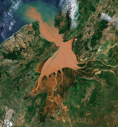 Image:
Resembling a reddish jellyfish, the Mahajamba Bay in Madagascar is imaged by Copernicus Sentinel-2.
Image:
Resembling a reddish jellyfish, the Mahajamba Bay in Madagascar is imaged by Copernicus Sentinel-2.
Mapová aplikace ÚPD - nové dokumentace
31.5.2024 9:40 Jihočeský krajV mapové aplikaci Územně plánovací dokumentace obcí byla aktualizována ÚPD obcí ORP Tábor - Turovec, ORP Č. Krumlov - Světlík, ORP Týn n Vlt. - Žimutice, ORP Dačice - Peč, ORP Č. Budějovice - Dobrá Voda, Hluboká nad Vltavou, Nákří, Vidov, Radošovice.
Mapová aplikace ÚPD - nové dokumentace
31.5.2024 9:10 Jihočeský krajV mapové aplikaci Územně plánovací dokumentace obcí byla aktualizována ÚPD obcí ORP Tábor - Turovec, ORP Č. Krumlov - Světlík, ORP Týn n Vlt. - Žimutice, ORP Dačice - Peč, ORP Č. Budějovice - Dobrá Voda, Hluboká n Vltavou, Nákří, Vidov, Radošovice.
Mapová aplikace ÚPD - nové dokumentace
31.5.2024 8:40 Jihočeský krajV mapové aplikaci Územně plánovací dokumentace obcí byla aktualizována ÚPD obcí ORP Tábor – Turovec, ORP Č. Krumlov – Světlík, ORP Týn n Vlt. – Žimutice, ORP Dačice – Peč, ORP Č. Budějovice – Dobrá Voda, Hluboká nad Vltavou, Nákří, Vidov, Radošovice.
Verze 2.1 Metodiky pro geodetické zaměřování ZPS
30.5.2024 14:24 ČÚZK - předpisy a opatření V záložce Metodika byl aktualizován dokument Metodika pro geodetické zaměřování ZPS DTM kraje a pro práci s dokumentacíAktualizovaný dokument ve verzi 2.1 vzala dne 29. května 2024 Koordinační rada správců DMVS a DTM na vědomí.
20240530_Vrchní referent / rada oddělení aktualizace KN
30.5.2024 13:33 ČÚZK /Urady/Katastralni-urady/Katastralni-urady/Katastralni-urad-pro-Stredocesky-kraj/Katastralni-pracoviste/KP-Melnik/O-uradu/Aktuality/20210922_Odborny-referent-oddeleni-aktualizace-(4)20240530_Vrchní referent / rada oddělení aktualizace KN
30.5.2024 13:33 ČÚZK - předpisy a opatření Katastrální úřad pro Středočeský kraj - Katastrální pracoviště Mělník Vyhlášení výběrového řízení: Vrchní referent / rada oddělení aktualizace KN V části "Úřední deska", v sekci "Oznámení a jiná úřední sdělení" bylo vystaveno "Oznámení o vyhlášení výběrového řízení na obsazení služebního místa Vrchní referent / rada oddělení aktualizace KN"Zapojte se do mapování nářečí
30.5.2024 11:53 Katedra geoinformatiky UP OlomoucPřipojte se do rozsáhlého výzkumu, který mapuje česká nářečí! Cílem webového dotazníku je zjistit, jak se proměnila nářeční slovní zásoba za uplynulých 50 let, k čemuž nám může pomoci každý rodilý český mluvčí – zajímá nás, jaká slova používají příslušníci mladších i starších generací z Čech, Moravy a Slezska. Budeme proto rádi, když se do […]
The post Zapojte se do mapování nářečí first appeared on Katedra geoinformatiky.
Výsledky soutěže Mapa roku za kartografická díla, vytvořená v roce 2023
30.5.2024 9:11 GeoBusiness Česká kartografická společnost zveřejnila na slavnostní akci 9. května 2024 výsledky 26. ročníku odborné soutěže Mapa roku v pěti soutěžních kategoriích. Atlasy, soubory a edice map V kategorii Atlasy, soubory a edice map byl oceněn Český úřad zeměměřický a katastrální za Základní topografické mapy České republiky. Do kategorie bylo přihlášeno 18 produktů od jedenácti vydavatelství. […]Výsledky soutěže Mapa roku za kartografická díla, vytvořená v roce 2023
30.5.2024 9:11 GeoBusinessČeská kartografická společnost zveřejnila na slavnostní akci 9. května 2024 výsledky 26. ročníku odborné soutěže Mapa roku v pěti soutěžních kategoriích. Atlasy, soubory a edice map V kategorii Atlasy, soubory a edice map byl oceněn Český úřad zeměměřický a katastrální za Základní topografické mapy České republiky. Do kategorie bylo přihlášeno 18 produktů od jedenácti vydavatelství. […]
The post Výsledky soutěže Mapa roku za kartografická díla, vytvořená v roce 2023 appeared first on GeoBusiness.
Údržba komunikačnej infraštruktúry rezortu
29.5.2024 20:00
ÚGKK SR
Dňa 30.05.2024 v čase od 19:00 hod. do 21:00 hod. bude vykonaná plánovaná údržba infraštruktúrnych zariadení rezortu (výmena a konfigurácia nových zariadení). Z uvedeného dôvodu v uvedenom čase nebudú dostupné služby portálov ESKN, ZBGIS, Zoznam stavieb, Rezortná transformačná služba, CICA a SKPOS.
Za vzniknuté problémy sa ospravedlňujeme.
#PortálESKN #od:30.05.2024@19:00 #do:30.05.2024@21:00
rada/odborný rada – opravy chyb v KN
29.5.2024 18:20 ČÚZK - předpisy a opatření Katastrální úřad pro hlavní město Prahu zveřejnil novou aktualitu: Ředitelka úřadu vyhlašuje výběrové řízení na pozici:rada/odborný rada – opravy chyb v KN
rada/odborný rada – opravy chyb v KN
29.5.2024 18:20 ČÚZK /Urady/Katastralni-urady/Katastralni-urady/Katastralni-urad-pro-hlavni-mesto-Prahu/O-uradu/Aktuality/rada-odborny-rada-–-opravy-chyb-v-KNrada/odborný rada – opravy chyb v KN
29.5.2024 18:18 ČÚZK - předpisy a opatření Katastrální úřad pro hlavní město Prahuvypisuje výběrové řízení na místo
rada/odborný rada – opravy chyb v KN
rada/odborný rada – opravy chyb v KN
29.5.2024 18:18 ČÚZK /Urady/Katastralni-urady/Katastralni-urady/Katastralni-urad-pro-hlavni-mesto-Prahu/Uredni-deska/Oznameni-a-jina-uredni-sdeleni/Volna-mista/rada-odborny-rada-–-opravy-chyb-v-KNrada/odborný rada – opravy chyb v KN
29.5.2024 18:18 ČÚZK - volná místa Katastrální úřad pro hlavní město Prahu vypisuje výběrové řízení na místo rada/odborný rada – opravy chyb v KNvrchní referent/rada – opravy chyb v KN
29.5.2024 18:13 ČÚZK - předpisy a opatření Katastrální úřad pro hlavní město Prahu zveřejnil novou aktualitu: Ředitelka úřadu vyhlašuje výběrové řízení na pozici:vrchní referent/rada – opravy chyb v KN
vrchní referent/rada – opravy chyb v KN
29.5.2024 18:13 ČÚZK /Urady/Katastralni-urady/Katastralni-urady/Katastralni-urad-pro-hlavni-mesto-Prahu/O-uradu/Aktuality/vrchni-referent-rada-–-opravy-chyb-v-KN-(1)vrchní referent/rada – opravy chyb v KN
29.5.2024 18:12 ČÚZK /Urady/Katastralni-urady/Katastralni-urady/Katastralni-urad-pro-hlavni-mesto-Prahu/Uredni-deska/Oznameni-a-jina-uredni-sdeleni/Volna-mista/vrchni-referent-rada-–-opravy-chyb-v-KN-(1)vrchní referent/rada – opravy chyb v KN
29.5.2024 18:12 ČÚZK - volná místa Katastrální úřad pro hlavní město Prahu vypisuje výběrové řízení na místo vrchní referent/rada – opravy chyb v KNvrchní referent/rada – opravy chyb v KN
29.5.2024 18:12 ČÚZK - předpisy a opatření Katastrální úřad pro hlavní město Prahuvypisuje výběrové řízení na místo
vrchní referent/rada – opravy chyb v KN
Endpointy webových služeb IS DMVS na PROD
29.5.2024 18:07 ČÚZK - předpisy a opatření V souvislosti s plánovaným přechodem na jednotnou státní doménu gov.cz Český úřad zeměměřický a katastrální v rámci produkčního prostředí IS DMVS upozorňuje uživatele na nutnou úpravu URL adres webových služeb, které jsou dostupné přes Internet. Nové adresy webových služeb IS DMVS jsou uvedeny v dokumentu Endpointy webových služeb IS DMVSPřechod na jednotnou státní doménu gov.cz je realizován na základě usnesení vlády ČR č. 578 ze dne 16. srpna 2023 o harmonogramu migrace ústředních orgánů státní správy na jednotnou doménu .gov.cz.
Endpointy webových služeb IS DMVS na PROD
29.5.2024 18:07 ČÚZK - předpisy a opatření V souvislosti s plánovaným přechodem na jednotnou státní doménu gov.cz Český úřad zeměměřický a katastrální v rámci produkčního prostředí IS DMVS upozorňuje uživatele na nutnou úpravu URL adres webových služeb, které jsou dostupné přes Internet. Nové adresy webových služeb IS DMVS jsou uvedeny v dokumentu Endpointy webových služeb IS DMVSPřechod na jednotnou státní doménu gov.cz je realizován na základě vládou ČR schváleného materiálu „Harmonogram migrace ústředních orgánů státní správy na jednotnou doménu.gov.cz“ ze dne 16. srpna 2023.
Europe’s largest ground segment updated with no user impact
29.5.2024 15:47 ESA Navigation
Over 200 dedicated professionals from ESA, EUSPA and European industry across four Galileo centres and seven external entities have seamlessly upgraded Galileo’s massive ground segment. In a remarkable feat of coordination and precision involving the deployment of 400 items, and after five months of rehearsals, Galileo’s ground segment, the largest in Europe, has transitioned seamlessly to System Build 2.0.
Nové verze 16.72
29.5.2024 15:39 GEPROPřipravili jsme pro vás nové verze 16.72 našich produktů. Stahovat je můžete z obvyklého umístění na našem download serveru. Novinky, které jsme pro vás nachystali: KOKEŠ MISYS PROLAND KOKEŠ Práce s daty Import JVF DTM: opraven import vybraných prvků z JVF verze 1.4.3 Geometrické plány Kótování – měřická přímka: opraveno umisťování textu kolmice, pokud kótovaný […]
Článek Nové verze 16.72 se nejdříve objevil na GEPRO.
20240529-Leták s informacemi
29.5.2024 11:09 ČÚZK - aktuality v resortu Leták s praktickými informacemi, jak správně a jednoduše požádat o vklad katastru nemovitostí elektronicky, najdete zde.20240529-Leták s informacemi
29.5.2024 11:09 ČÚZK - aktuality v resortu Leták s praktickými informacemi, jak správně a jednoduše požádat o vklad katastru nemovitostí elektronicky, najdete zde.20240529-Leták s informacemi
29.5.2024 11:09 ČÚZK - předpisy a opatření Český úřad zeměměřický a katastrální zveřejnil novou aktualitu: Leták s praktickými informacemi, jak správně a jednoduše požádat o vklad katastru nemovitostí elektronicky, najdete zde.20240529-Leták s informacemi
29.5.2024 11:09 ČÚZK - aktuality v resortu Leták s praktickými informacemi, jak správně a jednoduše požádat o vklad katastru nemovitostí elektronicky, najdete zde.20240529-Leták s informacemi
29.5.2024 11:09 ČÚZK - aktuality v resortu Leták s praktickými informacemi, jak správně a jednoduše požádat o vklad katastru nemovitostí elektronicky, najdete zde.20240529-Leták s informacemi
29.5.2024 11:09 ČÚZK /Aktuality-resort/2024/20240529-Letak-s-informacemiAsistent / Asistentka v personálním oddělení Katastrálního úřadu pro Zlínský kraj
29.5.2024 11:05 ČÚZK - předpisy a opatření Katastrální úřad pro Zlínský krajvypisuje výběrové řízení na místo
Asistent / Asistentka v personálním oddělení Katastrálního úřadu pro Zlínský kraj
Asistent / Asistentka v personálním oddělení Katastrálního úřadu pro Zlínský kraj
29.5.2024 11:05 ČÚZK - volná místa Katastrální úřad pro Zlínský kraj vypisuje výběrové řízení na místo Asistent / Asistentka v personálním oddělení Katastrálního úřadu pro Zlínský krajOdborný referent – poskytování informací KN, poskytování podkladů, nahlížení do KN, poskytování info
29.5.2024 10:48 ČÚZK /Urady/Katastralni-urady/Katastralni-urady/Katastralni-urad-pro-Zlinsky-kraj/Uredni-deska/Oznameni-a-jina-uredni-sdeleni/Volna-mista/DMS/Odborny-referent-–-poskytovani-informaci-KN,-p-(1)Odborný referent – poskytování informací KN, poskytování podkladů, nahlížení do KN, poskytování info
29.5.2024 10:48 ČÚZK - předpisy a opatření Katastrální úřad pro Zlínský kraj Katastrální pracoviště Zlínvypisuje výběrové řízení na místo
Odborný referent – poskytování informací KN, poskytování podkladů, nahlížení do KN, poskytování informací PK v oddělení dokumentace KN Katastrálního pracoviště Zlín
Odborný referent – poskytování informací KN, poskytování podkladů, nahlížení do KN, poskytování info
29.5.2024 10:48 ČÚZK - volná místa Katastrální úřad pro Zlínský kraj Katastrální pracoviště Zlín vypisuje výběrové řízení na místo Odborný referent – poskytování informací KN, poskytování podkladů, nahlížení do KN, poskytování infoEarthCARE is launched
29.5.2024 7:30 ESA Observing the Earth Video:
00:11:00
Video:
00:11:00
ESA’s EarthCARE satellite lifted off on a SpaceX Falcon 9 rocket from the Vandenberg Space Force Base in California, US, on 29 May at 00:20 CEST (28 May, 15:20 local time).
Developed as a cooperation between ESA and the Japan Aerospace Exploration Agency (JAXA), the Earth Cloud Aerosol and Radiation Explorer satellite carries a set of four instruments to make a range of different measurements that together will shed new light on the role that clouds and aerosols play in regulating Earth’s climate.
Taking EarthCARE into orbit
29.5.2024 7:00 ESA Observing the Earth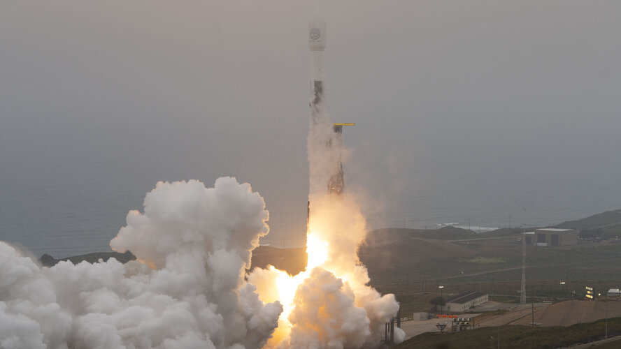 Video:
00:02:36
Video:
00:02:36
ESA’s EarthCARE satellite lifted off on a SpaceX Falcon 9 rocket from the Vandenberg Space Force Base in California, US, on 29 May at 00:20 CEST (28 May, 15:20 local time).
Developed as a cooperation between ESA and the Japan Aerospace Exploration Agency (JAXA), the Earth Cloud Aerosol and Radiation Explorer satellite carries a set of four instruments to make a range of different measurements that together will shed new light on the role that clouds and aerosols play in regulating Earth’s climate.
Replay: EarthCARE launch coverage
29.5.2024 7:00 ESA Observing the Earth Video:
02:15:00
Video:
02:15:00
Watch the replay of the EarthCARE launch coverage. The video includes streaming of the event at ESA’s European Space Operations Centre in Germany and footage of liftoff from the Vandenberg Space Force Base in California, US.
EarthCARE was lofted into orbit on a SpaceX Falcon 9 rocket on 29 May at 00:20 CEST (28 May, 15:20 local time).
Developed as a cooperation between ESA and the Japan Aerospace Exploration Agency (JAXA), the Earth Cloud Aerosol and Radiation Explorer satellite carries a set of four instruments to make a range of different measurements that together will shed new light on the role that clouds and aerosols play in regulating Earth’s climate. With the climate crisis increasingly affecting our planet, EarthCARE is poised to provide data for climate research, to improve the accuracy of climate models and to support numerical weather prediction.
EarthCARE is the most complex of ESA’s trailblazing Earth Explorer research missions – missions that deliver critical information to understand how our world functions and the impact that human activity is having on natural processes.
Taking EarthCARE into orbit
29.5.2024 7:00 ESA Observing the Earth Video:
00:02:36
Video:
00:02:36
ESA’s EarthCARE satellite lifted off on a SpaceX Falcon 9 rocket from the Vandenberg Space Force Base in California, US, on 29 May at 00:20 CEST (28 May, 15:20 local time).
Developed as a cooperation between ESA and the Japan Aerospace Exploration Agency (JAXA), the Earth Cloud Aerosol and Radiation Explorer satellite carries a set of four instruments to make a range of different measurements that together will shed new light on the role that clouds and aerosols play in regulating Earth’s climate.
EarthCARE launched to study role of clouds and aerosols in Earth's climate
29.5.2024 1:14 ESA Observing the Earth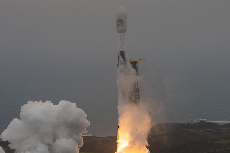
ESA’s EarthCARE satellite, poised to revolutionise our understanding of how clouds and aerosols affect our climate, has been launched. This extraordinary satellite embarked on its journey into space on 29 May at 00:20 CEST (28 May, 15:20 local time) aboard a Falcon 9 rocket from the Vandenberg Space Force Base in California, US.
Emlid Reach RS3 má přesnost 2 cm i při sklonu 60 stupňů. Testování GNSS přístroje s kompenzací náklonu
28.5.2024 21:07 ZeměměřičEmlid Reach RS3 je GNSS přístroj, která je zajímavý nejen svým měřením s kompenzací náklonu, ale také výdrží, hmotností či rychlostí fixace. Za zmínku stojí měřická aplikace Emlid Flow, která je čistě cloudová a ihned po změření odesílá data do vašeho cloudu. GNSS přístroj má hned několik funkcí, které jsou z geodetického pohledu zajímavé: vysoká přesnost s náklonem, kdy při náklonu […]
The post Emlid Reach RS3 má přesnost 2 cm i při sklonu 60 stupňů. Testování GNSS přístroje s kompenzací náklonu appeared first on Zeměměřič.
Úspěch našeho studenta v soutěži GISáček 2024 [Katedra aplikované geoinformatiky a kartografie, byTopic]
28.5.2024 20:00 Katedra aplikované geoinformatiky a kartografie Přf UK V minulém týdnu se 3 naši studenti Josef Zátka, Rostislav Berka a Adam Kulich zúčastnili soutěže GISáček na VŠB-TUO Ostrava. Josef Zátka se se svou prací „Analýza dat o poloze vozidel MHD: případová studie pro Most a Litvínov“ umístil na 1. místě v bakalářské kategorii. Gratulujeme! Image:
EarthCARE stands tall
Image:
EarthCARE stands tall
GEUS a DTM
28.5.2024 16:43 GEUSware Stav k 6.9.2024: Programem GEUS byla odevzdána už skoro desítka GAD! Vše tedy zdárně pokračuje, i když ne tak rychle, jak by bylo zapotřebí.V sekci Ke stažení naleznete novou verzi GEUS 28.1, která již základy práce s DTM obsahuje a zachovává veškerou předchozí funkčnost, tedy vše je v rámci jednoho programu.
Program uvolňujeme jako BETA verzi z pohledu DTM a v tomto stavu bude prezentován tak dlouho, dokud uživatelé nebudou hlásit, že dokáží s programem jednoduché GAD opravdu běžně zpracovat. Zatím bohužel nebyl čas na tak pečlivé testování, jako jsme byli v naší firmě zvyklí, proto jej uvolňujeme jako BETA, což znamená, že program stále obsahuje určité nedodělky. Tím rovnou přiznáváme, že aby veškerá funkčnost v GEUSu odpovídala standardům, na které jste byli zvyklí v ISKN, potřebovali bychom na vývoj ještě nějaký ten měsíc, nicméně GAD je zapotřebí odevzdávat už dva měsíce, tedy jdeme "s kůží na trh" v tuto chvíli, kdy zpoždění proti termínu 1.7.2024 i tak není malé.
Instruktážní videa se připravují.
Podrobnosti v článku!
GEUS a DTM
28.5.2024 16:43 GEUSware Stav k 3.10.2024: Programem GEUS byly odevzdány už desítky GAD a několik, které už nespadají do kategorie "jednoduché". Vše tedy zdárně pokračuje, i když ne tak rychle, jak by bylo ideální. Třeba zatím GEUS stále neumí oblasti ZPS. Viz proč BETA verze.V sekci Ke stažení naleznete další sestavení verze GEUS 28.1, která již základy práce s DTM obsahuje a zachovává veškerou předchozí funkčnost, tedy vše je v rámci jednoho programu.
Program je stále ještě ve stavu BETA verze z pohledu DTM a v tomto stavu bude prezentován tak dlouho, dokud uživatelé nebudou hlásit, že dokáží s programem jednoduché GAD opravdu běžně zpracovat. Zatím bohužel nebyl čas na tak pečlivé testování, jako jsme byli v naší firmě zvyklí, proto jej uvolňujeme jako BETA, což znamená, že program stále obsahuje určité nedodělky. Tím rovnou přiznáváme, že aby veškerá funkčnost v GEUSu odpovídala standardům, na které jste byli zvyklí v ISKN, potřebovali bychom na vývoj ještě nějaký ten měsíc.
Základní instruktážní video je zde. Další videa se připravují a naleznete je zde.
Podrobnosti v článku!
GEUS a DTM
28.5.2024 16:43 GEUSware Základní informace o připravované funkčnosti GEUSu pro oblast práce s JVF DTM.GEUS a DTM
28.5.2024 16:43 GEUSware Aktualizováno 9.7.2024: Dnes se nám podařilo připravit ALFA verzi progframu GEUS 28.1, která je k dispozici uživatelům verze 28.0 na vyžádání. Žádosti zasíljete prosím mailem na adresu podpora@geus.cz a obratem Vám budou zaslány údaje k jejímu stažení.ALFA verzi nelze použít k běžné práci a vytváření JVF, je určena pouze ke studiu logiky práce s DTM s ohledem na zvolenou logiku v programu GEUS!
Reálný termín pro dokončení v rozsahu popsaném v článku máme nyní stanovený na 2.9.2024.
Podrobnosti v článku!
GEUS a DTM
28.5.2024 16:43 GEUSware Aktualizováno 28.6.2024: Do 9.7. 2024 plánujme uvolnit řešení, které by umožnilo našim uživatelům zkoumat a studovat použité řešení DTM v programu GEUS. Reálný termín pro dokončení v rozsahu popsaném v článku máme nyní stanovený na 2.9.2024.Základní informace o připravované funkčnosti GEUSu pro oblast práce s JVF DTM.
GEUS a DTM
28.5.2024 16:43 GEUSware Aktualizováno 30.8.2024: Programem GEUS byla již odevzdána první GAD! Vše tedy zdárně pokračuje, i když ne tak rychle, jak by bylo zapotřebí. Tedy přesně ve slibovaný termín pondělí 2.9.2024 s největší pravbděpodobností ještě nic uvolňovat nebudeme. Nicméně odklad bude jen v rámci jednotek dní, aby šlo o skutečně použitelnou verzi, byť jen na jednoduché GAD.Konečný termín pro uvolnění GEUSu v rozsahu popsaném výše máme nyní stanovený na pátek 6.9.2024.
Program bude uvolněn jako BETA verze a v tomto stavu bude prezentován tak dlouho, dokud uživatelé nebudou hlásit, že dokáží s programem jednoduché GAD opravdu zpracovat. Zatím bohužel nebyl čas na tak pečlivé testování, jako jsme byli v naší firmě zvyklí, tedy zatím BETA.
Podrobnosti v článku!
GEUS a DTM
28.5.2024 16:43 GEUSware Stav k 3.10.2024: Programem GEUS byly odevzdány už desítky GAD a několik, které už nespadají do kategorie "jednoduché". Vše tedy zdárně pokračuje, i když ne tak rychle, jak by bylo ideální. Třeba zatím GEUS stále neumí oblasti ZPS. Viz proč BETA verze.V sekci Ke stažení naleznete další sestavení verze GEUS 28.1, která již základy práce s DTM obsahuje a zachovává veškerou předchozí funkčnost, tedy vše je v rámci jednoho programu.
Program je stále ještě ve stavu BETA verze z pohledu DTM a v tomto stavu bude prezentován tak dlouho, dokud uživatelé nebudou hlásit, že dokáží s programem jednoduché GAD opravdu běžně zpracovat. Zatím bohužel nebyl čas na tak pečlivé testování, jako jsme byli v naší firmě zvyklí, proto jej uvolňujeme jako BETA, což znamená, že program stále obsahuje určité nedodělky. Tím rovnou přiznáváme, že aby veškerá funkčnost v GEUSu odpovídala standardům, na které jste byli zvyklí v ISKN, potřebovali bychom na vývoj ještě nějaký ten měsíc, nicméně GAD je zapotřebí odevzdávat už dva měsíce, tedy jdeme "s kůží na trh" v tuto chvíli, kdy zpoždění proti termínu 1.7.2024 i tak není malé.
Základní instruktážní video je zde. Další videa se připravují.
Podrobnosti v článku!
GEUS a DTM
28.5.2024 16:43 GEUSware Stav k 11.9.2024: Programem GEUS byla odevzdány už desítky GAD! Vše tedy zdárně pokračuje, i když ne tak rychle, jak by bylo zapotřebí. Viz proč BETA verze.V sekci Ke stažení naleznete novou verzi GEUS 28.1, která již základy práce s DTM obsahuje a zachovává veškerou předchozí funkčnost, tedy vše je v rámci jednoho programu.
Program uvolňujeme jako BETA verzi z pohledu DTM a v tomto stavu bude prezentován tak dlouho, dokud uživatelé nebudou hlásit, že dokáží s programem jednoduché GAD opravdu běžně zpracovat. Zatím bohužel nebyl čas na tak pečlivé testování, jako jsme byli v naší firmě zvyklí, proto jej uvolňujeme jako BETA, což znamená, že program stále obsahuje určité nedodělky. Tím rovnou přiznáváme, že aby veškerá funkčnost v GEUSu odpovídala standardům, na které jste byli zvyklí v ISKN, potřebovali bychom na vývoj ještě nějaký ten měsíc, nicméně GAD je zapotřebí odevzdávat už dva měsíce, tedy jdeme "s kůží na trh" v tuto chvíli, kdy zpoždění proti termínu 1.7.2024 i tak není malé.
Základní instruktážní video je zde. Další videa se připravují.
Podrobnosti v článku!
GEUS a DTM
28.5.2024 16:43 GEUSware Stav k 11.9.2024: Programem GEUS byly odevzdány už desítky GAD! Vše tedy zdárně pokračuje, i když ne tak rychle, jak by bylo zapotřebí. Viz proč BETA verze.V sekci Ke stažení naleznete novou verzi GEUS 28.1, která již základy práce s DTM obsahuje a zachovává veškerou předchozí funkčnost, tedy vše je v rámci jednoho programu.
Program uvolňujeme jako BETA verzi z pohledu DTM a v tomto stavu bude prezentován tak dlouho, dokud uživatelé nebudou hlásit, že dokáží s programem jednoduché GAD opravdu běžně zpracovat. Zatím bohužel nebyl čas na tak pečlivé testování, jako jsme byli v naší firmě zvyklí, proto jej uvolňujeme jako BETA, což znamená, že program stále obsahuje určité nedodělky. Tím rovnou přiznáváme, že aby veškerá funkčnost v GEUSu odpovídala standardům, na které jste byli zvyklí v ISKN, potřebovali bychom na vývoj ještě nějaký ten měsíc, nicméně GAD je zapotřebí odevzdávat už dva měsíce, tedy jdeme "s kůží na trh" v tuto chvíli, kdy zpoždění proti termínu 1.7.2024 i tak není malé.
Základní instruktážní video je zde. Další videa se připravují.
Podrobnosti v článku!
GEUS a DTM
28.5.2024 16:43 GEUSware Aktualizováno 9.7.2024: Dnes se nám podařilo připravit ALFA verzi programu GEUS 28.1, která je k dispozici uživatelům verze 28.0 na vyžádání. Žádosti zasílejte prosím mailem na adresu podpora@geus.cz a obratem Vám budou zaslány údaje k jejímu stažení.ALFA verzi nelze použít k běžné práci a vytváření JVF, je určena pouze ke studiu logiky práce s DTM s ohledem na zvolenou logiku v programu GEUS!
Reálný termín pro dokončení v rozsahu popsaném v článku máme nyní stanovený na 2.9.2024.
Podrobnosti v článku!
GEUS a DTM
28.5.2024 16:43 GEUSware Stav k 6.9.2024: Programem GEUS byla odevzdána už skoro desítka GAD! Vše tedy zdárně pokračuje, i když ne tak rychle, jak by bylo zapotřebí.V sekci Ke stažení naleznete již během dnešního dne novou verzi GEUS 28.1, která již základy práce s DTM obsahuje a zachovává veškerou předchozí funkčnost, tedy vše je v rámci jednoho programu.
Program uvolňujeme jako BETA verzi z pohledu DTM a v tomto stavu bude prezentován tak dlouho, dokud uživatelé nebudou hlásit, že dokáží s programem jednoduché GAD opravdu běžně zpracovat. Zatím bohužel nebyl čas na tak pečlivé testování, jako jsme byli v naší firmě zvyklí, proto jej uvolňujeme jako BETA, což znamená, že program stále obsahuje určité nedodělky. Tím rovnou přiznáváme, že aby veškerá funkčnost v GEUSu odpovídala standardům, na které jste byli zvyklí v ISKN, potřebovali bychom na vývoj ještě nějaký ten měsíc, nicméně GAD je zapotřebí odevzdávat už dva měsíce, tedy jdeme "s kůží na trh" v tuto chvíli, kdy zpoždění proti termínu 1.7.2024 i tak není malé.
Instruktážní videa se připravují.
Podrobnosti v článku!
GEUS a DTM
28.5.2024 16:43 GEUSware Stav k 3.10.2024: Programem GEUS byly odevzdány už desítky GAD a několik, které už nespadají do kategorie "jednoduché". Vše tedy zdárně pokračuje, i když ne tak rychle, jak by bylo ideální. Třeba zatím GEUS stále neumí aktualizaci speciálního objektu "oblast kompletní ZPS". Viz proč BETA verze.V sekci Ke stažení naleznete další sestavení verze GEUS 28.1, která již základy práce s DTM obsahuje a zachovává veškerou předchozí funkčnost, tedy vše je v rámci jednoho programu.
Program je stále ještě ve stavu BETA verze z pohledu DTM a v tomto stavu bude prezentován tak dlouho, dokud uživatelé nebudou hlásit, že dokáží s programem jednoduché GAD opravdu běžně zpracovat.
Základní instruktážní video je zde. Další videa se připravují a naleznete je zde.
Podrobnosti v článku!
GEUS a DTM
28.5.2024 16:43 GEUSware Aktualizováno 30.8.2024: Programem GEUS byla již odevzdána první GAD! Vše tedy zdárně pokračuje, i když ne tak rychle, jak by bylo zapotřebí. Tedy přesně ve slibovaný termín pondělí 2.9.2024 s největší pravděpodobností ještě nic uvolňovat nebudeme. Nicméně odklad bude jen v rámci jednotek dní, aby šlo o skutečně použitelnou verzi, byť jen na jednoduché GAD.Termín pro uvolnění GEUSu v rozsahu popsaném výše máme nyní stanovený na pátek 6.9.2024.
Program bude uvolněn jako BETA verze a v tomto stavu bude prezentován tak dlouho, dokud uživatelé nebudou hlásit, že dokáží s programem jednoduché GAD opravdu zpracovat. Zatím bohužel nebyl čas na tak pečlivé testování, jako jsme byli v naší firmě zvyklí, tedy zatím BETA.
Podrobnosti v článku!
odborný rada – rozhodování o povolení vkladu práv k nemovitostem do KN
28.5.2024 16:06 ČÚZK /Urady/Katastralni-urady/Katastralni-urady/Katastralni-urad-pro-hlavni-mesto-Prahu/O-uradu/Aktuality/odborny-rada-–-rozhodovani-o-povoleni-vkladu-p-(2)odborný rada – rozhodování o povolení vkladu práv k nemovitostem do KN
28.5.2024 16:06 ČÚZK - předpisy a opatření Katastrální úřad pro hlavní město Prahu zveřejnil novou aktualitu: Ředitelka úřadu vyhlašuje výběrové řízení na pozici:odborný rada – rozhodování o povolení vkladu práv k nemovitostem do KN
odborný rada – rozhodování o povolení vkladu práv k nemovitostem do KN
28.5.2024 16:03 ČÚZK - volná místa Katastrální úřad pro hlavní město Prahu vypisuje výběrové řízení na místo odborný rada – rozhodování o povolení vkladu práv k nemovitostem do KNodborný rada – rozhodování o povolení vkladu práv k nemovitostem do KN
28.5.2024 16:03 ČÚZK /Urady/Katastralni-urady/Katastralni-urady/Katastralni-urad-pro-hlavni-mesto-Prahu/Uredni-deska/Oznameni-a-jina-uredni-sdeleni/Volna-mista/odborny-rada-–-rozhodovani-o-povoleni-vkladu-p-(3)odborný rada – rozhodování o povolení vkladu práv k nemovitostem do KN
28.5.2024 16:03 ČÚZK - předpisy a opatření Katastrální úřad pro hlavní město Prahuvypisuje výběrové řízení na místo
odborný rada – rozhodování o povolení vkladu práv k nemovitostem do KN
Zpřístupnění GP v Nahlížení KN pro geodety
28.5.2024 14:36 ČÚZK - předpisy a opatření Český úřad zeměměřický a katastrálnízveřejnil novou aktualitu: Upozorňujeme, že v rámci Nahlížení do KN pro geodety byla k možnosti stažení souborů ZPMZ nově doplněna rovněž možnost stažení souborů geometrických plánů. Jedná se o prosté kopie geometrických plánů (bez autentizačních prvků) poskytované výhradně odborně způsobilým osobám v režimu podkladů pro vyhotovení geometrického plánu nebo vytyčení hranice pozemků podle katastrální vyhlášky.
Zpřístupnění GP v Nahlížení KN pro geodety
28.5.2024 14:36 ČÚZK /Urady/Katastralni-urady/Katastralni-urady/Katastralni-urad-pro-Zlinsky-kraj/O-uradu/Aktuality/Zpristupneni-GP-v-Nahlizeni-KN-pro-geodetyZpřístupnění GP v Nahlížení KN pro geodety
28.5.2024 14:36 ČÚZK /Urady/Katastralni-urady/Katastralni-urady/Katastralni-urad-pro-Vysocinu/O-uradu/Aktuality/Zpristupneni-GP-v-Nahlizeni-KN-pro-geodetyZpřístupnění GP v Nahlížení KN pro geodety
28.5.2024 14:36 ČÚZK - předpisy a opatření Český úřad zeměměřický a katastrálnízveřejnil novou aktualitu: Upozorňujeme, že v rámci Nahlížení do KN pro geodety byla k možnosti stažení souborů ZPMZ nově doplněna rovněž možnost stažení souborů geometrických plánů. Jedná se o prosté kopie geometrických plánů (bez autentizačních prvků) poskytované výhradně odborně způsobilým osobám v režimu podkladů pro vyhotovení geometrického plánu nebo vytyčení hranice pozemků podle katastrální vyhlášky.
Zpřístupnění GP v Nahlížení KN pro geodety
28.5.2024 14:35 ČÚZK /Urady/Katastralni-urady/Katastralni-urady/Katastralni-urad-pro-Ustecky-kraj/O-uradu/Aktuality/Zpristupneni-GP-v-Nahlizeni-KN-pro-geodetyZpřístupnění GP v Nahlížení KN pro geodety
28.5.2024 14:35 ČÚZK - předpisy a opatření Český úřad zeměměřický a katastrálnízveřejnil novou aktualitu: Upozorňujeme, že v rámci Nahlížení do KN pro geodety byla k možnosti stažení souborů ZPMZ nově doplněna rovněž možnost stažení souborů geometrických plánů. Jedná se o prosté kopie geometrických plánů (bez autentizačních prvků) poskytované výhradně odborně způsobilým osobám v režimu podkladů pro vyhotovení geometrického plánu nebo vytyčení hranice pozemků podle katastrální vyhlášky.
Zpřístupnění GP v Nahlížení KN pro geodety
28.5.2024 14:35 ČÚZK /Urady/Katastralni-urady/Katastralni-urady/Katastralni-urad-pro-Stredocesky-kraj/O-uradu/Aktuality/Zpristupneni-GP-v-Nahlizeni-KN-pro-geodetyZpřístupnění GP v Nahlížení KN pro geodety
28.5.2024 14:35 ČÚZK - předpisy a opatření Český úřad zeměměřický a katastrálnízveřejnil novou aktualitu: Upozorňujeme, že v rámci Nahlížení do KN pro geodety byla k možnosti stažení souborů ZPMZ nově doplněna rovněž možnost stažení souborů geometrických plánů. Jedná se o prosté kopie geometrických plánů (bez autentizačních prvků) poskytované výhradně odborně způsobilým osobám v režimu podkladů pro vyhotovení geometrického plánu nebo vytyčení hranice pozemků podle katastrální vyhlášky.
Zpřístupnění GP v Nahlížení KN pro geodety
28.5.2024 14:35 ČÚZK /Urady/Katastralni-urady/Katastralni-urady/Katastralni-urad-pro-Plzensky-kraj/O-uradu/Aktuality/Zpristupneni-GP-v-Nahlizeni-KN-pro-geodetyZpřístupnění GP v Nahlížení KN pro geodety
28.5.2024 14:35 ČÚZK - předpisy a opatření Český úřad zeměměřický a katastrálnízveřejnil novou aktualitu: Upozorňujeme, že v rámci Nahlížení do KN pro geodety byla k možnosti stažení souborů ZPMZ nově doplněna rovněž možnost stažení souborů geometrických plánů. Jedná se o prosté kopie geometrických plánů (bez autentizačních prvků) poskytované výhradně odborně způsobilým osobám v režimu podkladů pro vyhotovení geometrického plánu nebo vytyčení hranice pozemků podle katastrální vyhlášky.
Zpřístupnění GP v Nahlížení KN pro geodety
28.5.2024 14:34 ČÚZK - předpisy a opatření Český úřad zeměměřický a katastrálnízveřejnil novou aktualitu: Upozorňujeme, že v rámci Nahlížení do KN pro geodety byla k možnosti stažení souborů ZPMZ nově doplněna rovněž možnost stažení souborů geometrických plánů. Jedná se o prosté kopie geometrických plánů (bez autentizačních prvků) poskytované výhradně odborně způsobilým osobám v režimu podkladů pro vyhotovení geometrického plánu nebo vytyčení hranice pozemků podle katastrální vyhlášky.
Zpřístupnění GP v Nahlížení KN pro geodety
28.5.2024 14:34 ČÚZK /Urady/Katastralni-urady/Katastralni-urady/Katastralni-urad-pro-Pardubicky-kraj/O-uradu/Aktuality/Zpristupneni-GP-v-Nahlizeni-KN-pro-geodetyZpřístupnění GP v Nahlížení KN pro geodety
28.5.2024 14:34 ČÚZK - předpisy a opatření Český úřad zeměměřický a katastrálnízveřejnil novou aktualitu: Upozorňujeme, že v rámci Nahlížení do KN pro geodety byla k možnosti stažení souborů ZPMZ nově doplněna rovněž možnost stažení souborů geometrických plánů. Jedná se o prosté kopie geometrických plánů (bez autentizačních prvků) poskytované výhradně odborně způsobilým osobám v režimu podkladů pro vyhotovení geometrického plánu nebo vytyčení hranice pozemků podle katastrální vyhlášky.
Zpřístupnění GP v Nahlížení KN pro geodety
28.5.2024 14:34 ČÚZK /Urady/Katastralni-urady/Katastralni-urady/Katastralni-urad-pro-Olomoucky-kraj/O-uradu/Aktuality/Zpristupneni-GP-v-Nahlizeni-KN-pro-geodetyZpřístupnění GP v Nahlížení KN pro geodety
28.5.2024 14:34 ČÚZK - předpisy a opatření Český úřad zeměměřický a katastrálnízveřejnil novou aktualitu: Upozorňujeme, že v rámci Nahlížení do KN pro geodety byla k možnosti stažení souborů ZPMZ nově doplněna rovněž možnost stažení souborů geometrických plánů. Jedná se o prosté kopie geometrických plánů (bez autentizačních prvků) poskytované výhradně odborně způsobilým osobám v režimu podkladů pro vyhotovení geometrického plánu nebo vytyčení hranice pozemků podle katastrální vyhlášky.
Zpřístupnění GP v Nahlížení KN pro geodety
28.5.2024 14:34 ČÚZK /Urady/Katastralni-urady/Katastralni-urady/Katastralni-urad-pro-Moravskoslezsky-kraj/O-uradu/Aktuality/Zpristupneni-GP-v-Nahlizeni-KN-pro-geodetyZpřístupnění GP v Nahlížení KN pro geodety
28.5.2024 14:33 ČÚZK /Urady/Katastralni-urady/Katastralni-urady/Katastralni-urad-pro-Liberecky-kraj/O-uradu/Aktuality/Zpristupneni-GP-v-Nahlizeni-KN-pro-geodetyZpřístupnění GP v Nahlížení KN pro geodety
28.5.2024 14:33 ČÚZK - předpisy a opatření Český úřad zeměměřický a katastrálnízveřejnil novou aktualitu: Upozorňujeme, že v rámci Nahlížení do KN pro geodety byla k možnosti stažení souborů ZPMZ nově doplněna rovněž možnost stažení souborů geometrických plánů. Jedná se o prosté kopie geometrických plánů (bez autentizačních prvků) poskytované výhradně odborně způsobilým osobám v režimu podkladů pro vyhotovení geometrického plánu nebo vytyčení hranice pozemků podle katastrální vyhlášky.
Zpřístupnění GP v Nahlížení KN pro geodety
28.5.2024 14:33 ČÚZK - předpisy a opatření Český úřad zeměměřický a katastrálnízveřejnil novou aktualitu: Upozorňujeme, že v rámci Nahlížení do KN pro geodety byla k možnosti stažení souborů ZPMZ nově doplněna rovněž možnost stažení souborů geometrických plánů. Jedná se o prosté kopie geometrických plánů (bez autentizačních prvků) poskytované výhradně odborně způsobilým osobám v režimu podkladů pro vyhotovení geometrického plánu nebo vytyčení hranice pozemků podle katastrální vyhlášky.