


![]()

zprávy
zdroje zpráv:Rada / odborný rada v oddělení právních vztahů k nemovitostem Katastrálního pracoviště Ústí nad Labe
6.2.2024 14:08 ČÚZK - volná místa Katastrální úřad pro Ústecký kraj Katastrální pracoviště Ústí nad Labem vypisuje výběrové řízení na místo Rada / odborný rada v oddělení právních vztahů k nemovitostem Katastrálního pracoviště Ústí nad LabeRada / odborný rada v oddělení právních vztahů k nemovitostem Katastrálního pracoviště Ústí nad Labe
6.2.2024 14:08 ČÚZK /Urady/Katastralni-urady/Katastralni-urady/Katastralni-urad-pro-Ustecky-kraj/Uredni-deska/Oznameni-a-jina-uredni-sdeleni/Volna-mista/DMS/Rada-odborny-rada-v-oddeleni-pravnich-vztahu-k-nem20240206 - změnový VFR číselníků
6.2.2024 13:35 ČÚZK /ruian/Poskytovani-udaju-ISUI-RUIAN-VDP/Vymenny-format-RUIAN-(VFR)/Archiv-novinek-VFR/2024/20240206-zmenovy-VFR-ciselnikuInformace o výsledcích kontrol dle § 26 zákona č. 255/2012 Sb. za rok 2023
6.2.2024 12:41 ČÚZK - předpisy a opatření Zeměměřický a katastrální inspektorát v Opavěvydává informace o výsledcích kontrol dle § 26 zákona č. 255/2012 Sb. za rok
2023
Rada / odborný rada – ředitel odboru Katastrálního pracoviště Vsetín
6.2.2024 11:45 ČÚZK - volná místa Katastrální úřad pro Zlínský kraj Katastrální pracoviště Vsetín vypisuje výběrové řízení na místo Rada / odborný rada – ředitel odboru Katastrálního pracoviště VsetínRada / odborný rada – ředitel odboru Katastrálního pracoviště Vsetín
6.2.2024 11:45 ČÚZK /Urady/Katastralni-urady/Katastralni-urady/Katastralni-urad-pro-Zlinsky-kraj/Uredni-deska/Oznameni-a-jina-uredni-sdeleni/Volna-mista/DMS/Rada-odborny-rada-–-reditel-odboru-Katastralniho-pRada / odborný rada – ředitel odboru Katastrálního pracoviště Vsetín
6.2.2024 11:45 ČÚZK - předpisy a opatření Katastrální úřad pro Zlínský kraj Katastrální pracoviště Vsetínvypisuje výběrové řízení na místo
Rada / odborný rada – ředitel odboru Katastrálního pracoviště Vsetín
Rada/odborný rada v oddělení právních vztahů k nemovitostem na Katastrálním pracovišti Blansko
6.2.2024 11:23 ČÚZK - volná místa Katastrální úřad pro Jihomoravský kraj vypisuje výběrové řízení na místo Rada/odborný rada v oddělení právních vztahů k nemovitostem na Katastrálním pracovišti BlanskoRada/odborný rada v oddělení právních vztahů k nemovitostem na Katastrálním pracovišti Blansko
6.2.2024 11:23 ČÚZK - předpisy a opatření Katastrální úřad pro Jihomoravský krajvypisuje výběrové řízení na místo
Rada/odborný rada v oddělení právních vztahů k nemovitostem na Katastrálním pracovišti Blansko
Odborný referent v oddělení právním na Katastrálním pracovišti Brno - venkov
6.2.2024 11:20 ČÚZK - předpisy a opatření Katastrální úřad pro Jihomoravský krajvypisuje výběrové řízení na místo
Odborný referent v oddělení právním na Katastrálním pracovišti Brno - venkov
Odborný referent v oddělení právním na Katastrálním pracovišti Brno - venkov
6.2.2024 11:20 ČÚZK - volná místa Katastrální úřad pro Jihomoravský kraj vypisuje výběrové řízení na místo Odborný referent v oddělení právním na Katastrálním pracovišti Brno - venkovZávada tel. ústředny Šumperk
6.2.2024 9:59 ČÚZK - předpisy a opatření Katastrální úřad pro Olomoucký kraj zveřejnil novou aktualitu: Havárie telefonní ústředny v Šumperku.Z důvodu havárie telefonní ústředny na Katastrálním pracovišti v Šumperku, je toto pracoviště dočasně telefonicky nedostupné.
Závada tel. ústředny Šumperk
6.2.2024 9:59 ČÚZK /Urady/Katastralni-urady/Katastralni-urady/Katastralni-urad-pro-Olomoucky-kraj/O-uradu/Aktuality/Zavada-tel-ustredny-SumperkÚčetní
6.2.2024 9:58 ČÚZK - předpisy a opatření Katastrální úřad pro Moravskoslezský kraj kancelář ředitelevypisuje výběrové řízení na místo
Účetní
Účetní
6.2.2024 9:58 ČÚZK - volná místa Katastrální úřad pro Moravskoslezský kraj kancelář ředitele vypisuje výběrové řízení na místo ÚčetníÚčetní
6.2.2024 9:58 ČÚZK /Urady/Katastralni-urady/Katastralni-urady/Katastralni-urad-pro-Moravskoslezsky-kraj/Volna-mista/DMS/UcetniOdborný referent – zápisy v řízení V a Z v oddělení právních vztahů k nemovitostem Katastrálního pra
6.2.2024 9:55 ČÚZK - předpisy a opatření Katastrální úřad pro Zlínský kraj Katastrální pracoviště Holešovvypisuje výběrové řízení na místo
Odborný referent – zápisy v řízení V a Z v oddělení právních vztahů k nemovitostem Katastrálního pracoviště Holešov
Odborný referent – zápisy v řízení V a Z v oddělení právních vztahů k nemovitostem Katastrálního pra
6.2.2024 9:55 ČÚZK - volná místa Katastrální úřad pro Zlínský kraj Katastrální pracoviště Holešov vypisuje výběrové řízení na místo Odborný referent – zápisy v řízení V a Z v oddělení právních vztahů k nemovitostem Katastrálního praDomovník
6.2.2024 9:54 ČÚZK - předpisy a opatření Katastrální úřad pro Moravskoslezský kraj Katastrální pracoviště Ostravavypisuje výběrové řízení na místo
Domovník
Domovník
6.2.2024 9:54 ČÚZK /Urady/Katastralni-urady/Katastralni-urady/Katastralni-urad-pro-Moravskoslezsky-kraj/Volna-mista/DMS/DomovnikDomovník
6.2.2024 9:54 ČÚZK - volná místa Katastrální úřad pro Moravskoslezský kraj Katastrální pracoviště Ostrava vypisuje výběrové řízení na místo DomovníkOdborný referent/vrchní referent – obnova katastrálního operátu
6.2.2024 9:52 ČÚZK - předpisy a opatření Katastrální úřad pro Moravskoslezský kraj Katastrální pracoviště Třinecvypisuje výběrové řízení na místo
Odborný referent/vrchní referent – obnova katastrálního operátu
Odborný referent/vrchní referent – obnova katastrálního operátu
6.2.2024 9:52 ČÚZK /Urady/Katastralni-urady/Katastralni-urady/Katastralni-urad-pro-Moravskoslezsky-kraj/Uredni-deska/Oznameni-a-jina-uredni-sdeleni/Volna-mista/DMS/Odborny-referent-vrchni-referent-–-obnova-kata-(2)Odborný referent/vrchní referent – obnova katastrálního operátu
6.2.2024 9:52 ČÚZK - volná místa Katastrální úřad pro Moravskoslezský kraj Katastrální pracoviště Třinec vypisuje výběrové řízení na místo Odborný referent/vrchní referent – obnova katastrálního operátuOdborný referent – vedení katastrální mapy
6.2.2024 9:48 ČÚZK - předpisy a opatření Katastrální úřad pro Moravskoslezský kraj Katastrální pracoviště Třinecvypisuje výběrové řízení na místo
Odborný referent – vedení katastrální mapy
Odborný referent – vedení katastrální mapy
6.2.2024 9:48 ČÚZK - volná místa Katastrální úřad pro Moravskoslezský kraj Katastrální pracoviště Třinec vypisuje výběrové řízení na místo Odborný referent – vedení katastrální mapyOdborný referent – vedení katastrální mapy
6.2.2024 9:48 ČÚZK /Urady/Katastralni-urady/Katastralni-urady/Katastralni-urad-pro-Moravskoslezsky-kraj/Uredni-deska/Oznameni-a-jina-uredni-sdeleni/Volna-mista/DMS/Odborny-referent-–-vedeni-katastralni-mapyOdborný referent – zápisy v řízení V a Z
6.2.2024 9:43 ČÚZK - volná místa Katastrální úřad pro Moravskoslezský kraj Katastrální pracoviště Ostrava vypisuje výběrové řízení na místo Odborný referent – zápisy v řízení V a ZOdborný referent – zápisy v řízení V a Z
6.2.2024 9:43 ČÚZK - předpisy a opatření Katastrální úřad pro Moravskoslezský kraj Katastrální pracoviště Ostravavypisuje výběrové řízení na místo
Odborný referent – zápisy v řízení V a Z
Vrchní referent/rada – vedení katastrální mapy
6.2.2024 9:39 ČÚZK - předpisy a opatření Katastrální úřad pro Moravskoslezský kraj Katastrální pracoviště Ostravavypisuje výběrové řízení na místo
Vrchní referent/rada – vedení katastrální mapy
Vrchní referent/rada – vedení katastrální mapy
6.2.2024 9:39 ČÚZK /Urady/Katastralni-urady/Katastralni-urady/Katastralni-urad-pro-Moravskoslezsky-kraj/Uredni-deska/Oznameni-a-jina-uredni-sdeleni/Volna-mista/DMS/Vrchni-referent-rada-–-vedeni-katastralni-mapyVrchní referent/rada – vedení katastrální mapy
6.2.2024 9:39 ČÚZK - volná místa Katastrální úřad pro Moravskoslezský kraj Katastrální pracoviště Ostrava vypisuje výběrové řízení na místo Vrchní referent/rada – vedení katastrální mapyVrchní referent/rada – obnova katastrálního operátu
6.2.2024 9:36 ČÚZK - předpisy a opatření Katastrální úřad pro Moravskoslezský kraj Katastrální pracoviště Ostravavypisuje výběrové řízení na místo
Vrchní referent/rada – obnova katastrálního operátu
Vrchní referent/rada – obnova katastrálního operátu
6.2.2024 9:36 ČÚZK /Urady/Katastralni-urady/Katastralni-urady/Katastralni-urad-pro-Moravskoslezsky-kraj/Uredni-deska/Oznameni-a-jina-uredni-sdeleni/Volna-mista/DMS/Vrchni-referent-rada-–-obnova-katastralniho-op-(3)Vrchní referent/rada – obnova katastrálního operátu
6.2.2024 9:36 ČÚZK - volná místa Katastrální úřad pro Moravskoslezský kraj Katastrální pracoviště Ostrava vypisuje výběrové řízení na místo Vrchní referent/rada – obnova katastrálního operátuOdborný referent/vrchní referent – poskytování informací KN
6.2.2024 9:33 ČÚZK /Urady/Katastralni-urady/Katastralni-urady/Katastralni-urad-pro-Moravskoslezsky-kraj/Uredni-deska/Oznameni-a-jina-uredni-sdeleni/Volna-mista/DMS/Odborny-referent-vrchni-referent-–-poskytovani-infOdborný referent/vrchní referent – poskytování informací KN
6.2.2024 9:33 ČÚZK - volná místa Katastrální úřad pro Moravskoslezský kraj Katastrální pracoviště Opava vypisuje výběrové řízení na místo Odborný referent/vrchní referent – poskytování informací KNOdborný referent/vrchní referent – poskytování informací KN
6.2.2024 9:33 ČÚZK - předpisy a opatření Katastrální úřad pro Moravskoslezský kraj Katastrální pracoviště Opavavypisuje výběrové řízení na místo
Odborný referent/vrchní referent – poskytování informací KN
Rada/odborný rada – obnova katastrálního operátu
6.2.2024 9:29 ČÚZK - volná místa Katastrální úřad pro Moravskoslezský kraj Katastrální pracoviště Frýdek-Místek vypisuje výběrové řízení na místo Rada/odborný rada – obnova katastrálního operátuRada/odborný rada – obnova katastrálního operátu
6.2.2024 9:29 ČÚZK /Urady/Katastralni-urady/Katastralni-urady/Katastralni-urad-pro-Moravskoslezsky-kraj/Uredni-deska/Oznameni-a-jina-uredni-sdeleni/Volna-mista/DMS/Rada-odborny-rada-–-obnova-katastralniho-operatuRada/odborný rada – obnova katastrálního operátu
6.2.2024 9:29 ČÚZK - předpisy a opatření Katastrální úřad pro Moravskoslezský kraj Katastrální pracoviště Frýdek-Místekvypisuje výběrové řízení na místo
Rada/odborný rada – obnova katastrálního operátu
Rada/odborný rada – řízení o opravě chyby v SPI
6.2.2024 9:26 ČÚZK /Urady/Katastralni-urady/Katastralni-urady/Katastralni-urad-pro-Moravskoslezsky-kraj/Uredni-deska/Oznameni-a-jina-uredni-sdeleni/Volna-mista/DMS/Rada-odborny-rada-–-rizeni-o-oprave-chyby-v-SPIRada/odborný rada – řízení o opravě chyby v SPI
6.2.2024 9:26 ČÚZK - předpisy a opatření Katastrální úřad pro Moravskoslezský kraj Katastrální pracoviště Frýdek-Místekvypisuje výběrové řízení na místo
Rada/odborný rada – řízení o opravě chyby v SPI
Rada/odborný rada – řízení o opravě chyby v SPI
6.2.2024 9:26 ČÚZK - volná místa Katastrální úřad pro Moravskoslezský kraj Katastrální pracoviště Frýdek-Místek vypisuje výběrové řízení na místo Rada/odborný rada – řízení o opravě chyby v SPIVrchní referent/rada – kontrola listin určených k záznamu
6.2.2024 9:22 ČÚZK - volná místa Katastrální úřad pro Moravskoslezský kraj Katastrální pracoviště Frýdek-Místek vypisuje výběrové řízení na místo Vrchní referent/rada – kontrola listin určených k záznamuVrchní referent/rada – kontrola listin určených k záznamu
6.2.2024 9:22 ČÚZK - předpisy a opatření Katastrální úřad pro Moravskoslezský kraj Katastrální pracoviště Frýdek-Místekvypisuje výběrové řízení na místo
Vrchní referent/rada – kontrola listin určených k záznamu
Vrchní referent/rada – kontrola listin určených k záznamu
6.2.2024 9:22 ČÚZK /Urady/Katastralni-urady/Katastralni-urady/Katastralni-urad-pro-Moravskoslezsky-kraj/Uredni-deska/Oznameni-a-jina-uredni-sdeleni/Volna-mista/DMS/Vrchni-referent-rada-–-kontrola-listin-urcenych-k-Vrchní referent/rada – obnova katastrálního operátu
6.2.2024 9:19 ČÚZK - předpisy a opatření Katastrální úřad pro Moravskoslezský kraj Katastrální pracoviště Bruntálvypisuje výběrové řízení na místo
Vrchní referent/rada – obnova katastrálního operátu
Vrchní referent/rada – obnova katastrálního operátu
6.2.2024 9:19 ČÚZK /Urady/Katastralni-urady/Katastralni-urady/Katastralni-urad-pro-Moravskoslezsky-kraj/Uredni-deska/Oznameni-a-jina-uredni-sdeleni/Volna-mista/DMS/Vrchni-referent-rada-–-obnova-katastralniho-op-(2)Vrchní referent/rada – obnova katastrálního operátu
6.2.2024 9:19 ČÚZK - volná místa Katastrální úřad pro Moravskoslezský kraj Katastrální pracoviště Bruntál vypisuje výběrové řízení na místo Vrchní referent/rada – obnova katastrálního operátuRada/odborný rada – správce informačních a komunikačních technologií
6.2.2024 9:16 ČÚZK - předpisy a opatření Katastrální úřad pro Moravskoslezský kraj technický odborvypisuje výběrové řízení na místo
Rada/odborný rada – správce informačních a komunikačních technologií
Rada/odborný rada – správce informačních a komunikačních technologií
6.2.2024 9:16 ČÚZK /Urady/Katastralni-urady/Katastralni-urady/Katastralni-urad-pro-Moravskoslezsky-kraj/Uredni-deska/Oznameni-a-jina-uredni-sdeleni/Volna-mista/DMS/Rada-odborny-rada-–-spravce-informacnich-a-komunikRada/odborný rada – správce informačních a komunikačních technologií
6.2.2024 9:16 ČÚZK - volná místa Katastrální úřad pro Moravskoslezský kraj technický odbor vypisuje výběrové řízení na místo Rada/odborný rada – správce informačních a komunikačních technologiíVrchní referent/rada – obnova katastrálního operátu
6.2.2024 9:13 ČÚZK /Urady/Katastralni-urady/Katastralni-urady/Katastralni-urad-pro-Moravskoslezsky-kraj/Uredni-deska/Oznameni-a-jina-uredni-sdeleni/Volna-mista/DMS/Vrchni-referent-rada-–-obnova-katastralniho-op-(1)Vrchní referent/rada – obnova katastrálního operátu
6.2.2024 9:13 ČÚZK - volná místa Katastrální úřad pro Moravskoslezský kraj technický odbor vypisuje výběrové řízení na místo Vrchní referent/rada – obnova katastrálního operátuVrchní referent/rada – obnova katastrálního operátu
6.2.2024 9:13 ČÚZK - předpisy a opatření Katastrální úřad pro Moravskoslezský kraj technický odborvypisuje výběrové řízení na místo
Vrchní referent/rada – obnova katastrálního operátu
Odborný referent/vrchní referent – obnova katastrálního operátu
6.2.2024 9:06 ČÚZK - předpisy a opatření Katastrální úřad pro Moravskoslezský kraj technický odborvypisuje výběrové řízení na místo
Odborný referent/vrchní referent – obnova katastrálního operátu
Odborný referent/vrchní referent – obnova katastrálního operátu
6.2.2024 9:06 ČÚZK /Urady/Katastralni-urady/Katastralni-urady/Katastralni-urad-pro-Moravskoslezsky-kraj/Uredni-deska/Oznameni-a-jina-uredni-sdeleni/Volna-mista/DMS/Odborny-referent-vrchni-referent-–-obnova-kata-(1)Odborný referent/vrchní referent – obnova katastrálního operátu
6.2.2024 9:06 ČÚZK - volná místa Katastrální úřad pro Moravskoslezský kraj technický odbor vypisuje výběrové řízení na místo Odborný referent/vrchní referent – obnova katastrálního operátuOdborný referent/vrchní referent – obnova katastrálního operátu
6.2.2024 9:02 ČÚZK - předpisy a opatření Katastrální úřad pro Moravskoslezský kraj technický odborvypisuje výběrové řízení na místo
Odborný referent/vrchní referent – obnova katastrálního operátu
Odborný referent/vrchní referent – obnova katastrálního operátu
6.2.2024 9:02 ČÚZK - volná místa Katastrální úřad pro Moravskoslezský kraj technický odbor vypisuje výběrové řízení na místo Odborný referent/vrchní referent – obnova katastrálního operátuOdborný referent/vrchní referent – obnova katastrálního operátu
6.2.2024 9:02 ČÚZK /Urady/Katastralni-urady/Katastralni-urady/Katastralni-urad-pro-Moravskoslezsky-kraj/Uredni-deska/Oznameni-a-jina-uredni-sdeleni/Volna-mista/DMS/Odborny-referent-vrchni-referent-–-obnova-katastraOdborný referent/vrchní referent – budování podrobných bodových polí
6.2.2024 8:59 ČÚZK /Urady/Katastralni-urady/Katastralni-urady/Katastralni-urad-pro-Moravskoslezsky-kraj/Uredni-deska/Oznameni-a-jina-uredni-sdeleni/Volna-mista/DMS/Odborny-referent-vrchni-referent-–-budovani-podrobOdborný referent/vrchní referent – budování podrobných bodových polí
6.2.2024 8:59 ČÚZK - předpisy a opatření Katastrální úřad pro Moravskoslezský kraj technický odborvypisuje výběrové řízení na místo
Odborný referent/vrchní referent – budování podrobných bodových polí
Odborný referent/vrchní referent – budování podrobných bodových polí
6.2.2024 8:59 ČÚZK - volná místa Katastrální úřad pro Moravskoslezský kraj technický odbor vypisuje výběrové řízení na místo Odborný referent/vrchní referent – budování podrobných bodových políVrchní referent/rada – obnova katastrálního operátu
6.2.2024 8:55 ČÚZK - volná místa Katastrální úřad pro Moravskoslezský kraj technický odbor vypisuje výběrové řízení na místo Vrchní referent/rada – obnova katastrálního operátuVrchní referent/rada – obnova katastrálního operátu
6.2.2024 8:55 ČÚZK - předpisy a opatření Katastrální úřad pro Moravskoslezský kraj technický odborvypisuje výběrové řízení na místo
Vrchní referent/rada – obnova katastrálního operátu
Výroční zpráva dle zákona č. 106/1999 Sb. za rok 2023
6.2.2024 8:35 ČÚZK /Urady/Katastralni-urady/Katastralni-urady/Katastralni-urad-pro-Ustecky-kraj/Vyrocni-zpravy/Vyrocni-zprava-dle-zakona-c-106-1999-Sb-za-rok-(5)Výroční zpráva dle zákona č. 106/1999 Sb. za rok 2023
6.2.2024 8:35 ČÚZK - předpisy a opatření Katastrální úřad pro Ústecký krajvydává výroční zprávu úřadu za rok
2023
18. kartografický den Olomouc – Kartografie & Vesmír
5.2.2024 18:56 GISportal.cz
Tradičně v poslední únorový pátek 23. února 2024 se v Olomouci uskuteční v pořadí již 18. kartografický den, tradiční jednodenní seminář, který propojuje odborníky na různá témata s komunitou kartografů. Tématem letošního ročníku je Kartografie a VESMÍR. Vesmír je obrovský, téměř nekonečný dynamický časoprostor, který obsahuje všechny známé formy hmoty a energie, včetně galaxií, hvězd, planet, meziplanetárního […]
The post 18. kartografický den Olomouc – Kartografie & Vesmír appeared first on GISportal.cz.
18. kartografický den Olomouc – Kartografie & Vesmír
5.2.2024 18:56 GISportal.czTradičně v poslední únorový pátek 23. února 2024 se v Olomouci uskuteční v pořadí již 18. kartografický den, tradiční jednodenní seminář, který propojuje odborníky na různá témata s komunitou kartografů. Tématem letošního ročníku je Kartografie a VESMÍR. Vesmír je obrovský, téměř nekonečný dynamický časoprostor, který obsahuje všechny známé formy hmoty a energie, včetně galaxií, hvězd, planet, meziplanetárního […]
The post 18. kartografický den Olomouc – Kartografie & Vesmír appeared first on GISportal.cz.
Ředitel/ředitelka Odboru geodetických základů
5.2.2024 15:48 ČÚZK /Urady/Zememericky-urad/Uredni-deska/Oznameni-a-jina-uredni-sdeleni/Volna-mista/DMS/Reditel-reditelka-Odboru-geodetickych-zakladuŘeditel/ředitelka Odboru geodetických základů
5.2.2024 15:48 ČÚZK - volná místa Zeměměřický úřad vypisuje výběrové řízení na místo Ředitel/ředitelka Odboru geodetických základůŘeditel/ředitelka Odboru geodetických základů
5.2.2024 15:48 ČÚZK - předpisy a opatření Zeměměřický úřadvypisuje výběrové řízení na místo
Ředitel/ředitelka Odboru geodetických základů
Ředitel/ředitelka Odboru geodetických základů
5.2.2024 15:48 Zeměměřický úřad Zeměměřický úřadvypisuje výběrové řízení na místo
Ředitel/ředitelka Odboru geodetických základů
Ředitel/ředitelka Odboru správy a rozvoje informačního systému zeměměřictví
5.2.2024 15:46 ČÚZK /Urady/Zememericky-urad/Uredni-deska/Oznameni-a-jina-uredni-sdeleni/Volna-mista/DMS/Reditel-reditelka-Odboru-spravy-a-rozvoje-informacŘeditel/ředitelka Odboru správy a rozvoje informačního systému zeměměřictví
5.2.2024 15:46 ČÚZK - volná místa Zeměměřický úřad vypisuje výběrové řízení na místo Ředitel/ředitelka Odboru správy a rozvoje informačního systému zeměměřictvíŘeditel/ředitelka Odboru správy a rozvoje informačního systému zeměměřictví
5.2.2024 15:46 ČÚZK - předpisy a opatření Zeměměřický úřadvypisuje výběrové řízení na místo
Ředitel/ředitelka Odboru správy a rozvoje informačního systému zeměměřictví
Ředitel/ředitelka Odboru správy a rozvoje informačního systému zeměměřictví
5.2.2024 15:46 Zeměměřický úřad Zeměměřický úřadvypisuje výběrové řízení na místo
Ředitel/ředitelka Odboru správy a rozvoje informačního systému zeměměřictví
20240205-VŘ KP Boskovice
5.2.2024 12:51 ČÚZK - aktuality v resortu Oznámení o vyhlášení výběrového řízení na obsazení služebního místa ředitele/ ředitelky Katastrálního pracoviště Boskovice.20240205-VŘ KP Boskovice
5.2.2024 12:51 ČÚZK - aktuality v resortu Oznámení o vyhlášení výběrového řízení na obsazení služebního místa ředitele/ ředitelky Katastrálního pracoviště Boskovice.20240205-VŘ KP Boskovice
5.2.2024 12:51 ČÚZK - předpisy a opatření Český úřad zeměměřický a katastrální zveřejnil novou aktualitu: Oznámení o vyhlášení výběrového řízení na obsazení služebního místa ředitele/ ředitelky Katastrálního pracoviště Boskovice.20240205-VŘ KP Boskovice
5.2.2024 12:51 ČÚZK - předpisy a opatření Český úřad zeměměřický a katastrálnízveřejnil novou aktualitu: Oznámení o vyhlášení výběrového řízení na obsazení služebního místa ředitele/ ředitelky Katastrálního pracoviště Boskovice.
Heritage ERS-2 satellite to reenter Earth’s atmosphere
5.2.2024 12:00 ESA Observing the Earth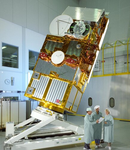
Throughout its 16-year working life, the second European Remote Sensing satellite, ERS-2, returned a wealth of information that revolutionised our perspective of our planet and understanding of climate change. As well as leaving a remarkable legacy of data that still continue to advance science, this outstanding mission set the stage for many of today’s satellites and ESA’s position at the forefront of Earth observation.
In 2011, ESA retired ERS-2 and began the process of deorbiting – and now it’s time for this pioneering satellite to reenter the atmosphere naturally and start to burn up.
Pokladna ohnivzdorná (trezor)
5.2.2024 10:59 ČÚZK /Urady/Katastralni-urady/Katastralni-urady/Katastralni-urad-pro-Vysocinu/Nabidky-majetku/Pokladna-ohnivzdorna-(trezor)Pokladna ohnivzdorná (trezor)
5.2.2024 10:59 ČÚZK - předpisy a opatřeníKatastrální úřad pro Vysočinu nabízí nepotřebný majetek k odkupu. Jedná se o
Pokladna ohnivzdorná (trezor)
20240205_Odborný / vrchní referent oddělení dokumentace KN
5.2.2024 10:56 ČÚZK - předpisy a opatření Katastrální úřad pro Středočeský kraj - Katastrální pracoviště Rakovník Vyhlášení výběrového řízení: Odborný / vrchní referent oddělení dokumentace KN V části "Úřední deska", v sekci "Oznámení a jiná úřední sdělení" bylo vystaveno "Oznámení o vyhlášení výběrového řízení na obsazení služebního místa Odborný / vrchní referent oddělení dokumentace KN"20240205_Odborný / vrchní referent oddělení dokumentace KN
5.2.2024 10:56 ČÚZK /Urady/Katastralni-urady/Katastralni-urady/Katastralni-urad-pro-Stredocesky-kraj/Katastralni-pracoviste/KP-Rakovnik/O-uradu/Aktuality/20210922_Odborny-referent-oddeleni-aktualizace-(1)Odborný / vrchní referent oddělení dokumentace KN
5.2.2024 10:55 ČÚZK - předpisy a opatření Katastrální úřad pro Středočeský kraj Katastrální pracoviště Rakovníkvypisuje výběrové řízení na místo
Odborný / vrchní referent oddělení dokumentace KN
Odborný / vrchní referent oddělení dokumentace KN
5.2.2024 10:55 ČÚZK - volná místa Katastrální úřad pro Středočeský kraj Katastrální pracoviště Rakovník vypisuje výběrové řízení na místo Odborný / vrchní referent oddělení dokumentace KNVrchní referent/rada v oddělení obnovy katastrálního operátu č.3 na Technické sekci
5.2.2024 8:36 ČÚZK - předpisy a opatření Katastrální úřad pro Jihomoravský krajvypisuje výběrové řízení na místo
Vrchní referent/rada v oddělení obnovy katastrálního operátu č.3 na Technické sekci
Vrchní referent/rada v oddělení obnovy katastrálního operátu č.3 na Technické sekci
5.2.2024 8:36 ČÚZK - volná místa Katastrální úřad pro Jihomoravský kraj vypisuje výběrové řízení na místo Vrchní referent/rada v oddělení obnovy katastrálního operátu č.3 na Technické sekciOdborný referent/vrchní referent v oddělení obnovy katastrálního operátu č.5 na Technické sekci
5.2.2024 8:27 ČÚZK - předpisy a opatření Katastrální úřad pro Jihomoravský kraj technická sekcevypisuje výběrové řízení na místo
Odborný referent/vrchní referent v oddělení obnovy katastrálního operátu č.5 na Technické sekci
Odborný referent/vrchní referent v oddělení obnovy katastrálního operátu č.5 na Technické sekci
5.2.2024 8:27 ČÚZK /Urady/Katastralni-urady/Katastralni-urady/Katastralni-urad-pro-Jihomoravsky-kraj/Uredni-deska/Oznameni-a-jina-uredni-sdeleni/Volna-mista/DMS/Odborny-referent-vrchni-referent-v-oddeleni-obnovyOdborný referent/vrchní referent v oddělení obnovy katastrálního operátu č.5 na Technické sekci
5.2.2024 8:27 ČÚZK - volná místa Katastrální úřad pro Jihomoravský kraj vypisuje výběrové řízení na místo Odborný referent/vrchní referent v oddělení obnovy katastrálního operátu č.5 na Technické sekciOdborný referent/vrchní referent v oddělení obnovy katastrálního operátu č.5 na Technické sekci
5.2.2024 8:27 ČÚZK - předpisy a opatření Katastrální úřad pro Jihomoravský krajvypisuje výběrové řízení na místo
Odborný referent/vrchní referent v oddělení obnovy katastrálního operátu č.5 na Technické sekci
Rada/odborný rada - ředitel/ka Kastastrálního pracoviště Boskovice
5.2.2024 8:20 ČÚZK - předpisy a opatření Katastrální úřad pro Jihomoravský kraj Katastrální pracoviště Boskovicevypisuje výběrové řízení na místo
Rada/odborný rada - ředitel/ka Kastastrálního pracoviště Boskovice
Rada/odborný rada - ředitel/ka Kastastrálního pracoviště Boskovice
5.2.2024 8:20 ČÚZK - volná místa Katastrální úřad pro Jihomoravský kraj vypisuje výběrové řízení na místo Rada/odborný rada - ředitel/ka Kastastrálního pracoviště BoskoviceRada/odborný rada - ředitel/ka Kastastrálního pracoviště Boskovice
5.2.2024 8:20 ČÚZK - volná místa Katastrální úřad pro Jihomoravský kraj Katastrální pracoviště Boskovice vypisuje výběrové řízení na místo Rada/odborný rada - ředitel/ka Kastastrálního pracoviště BoskoviceRada/odborný rada - ředitel/ka Kastastrálního pracoviště Boskovice
5.2.2024 8:20 ČÚZK /Urady/Katastralni-urady/Katastralni-urady/Katastralni-urad-pro-Jihomoravsky-kraj/Uredni-deska/Oznameni-a-jina-uredni-sdeleni/Volna-mista/DMS/Rada-odborny-rada-reditel-ka-Kastastralniho-pracovRada/odborný rada - ředitel/ka Kastastrálního pracoviště Boskovice
5.2.2024 8:20 ČÚZK - předpisy a opatření Katastrální úřad pro Jihomoravský krajvypisuje výběrové řízení na místo
Rada/odborný rada - ředitel/ka Kastastrálního pracoviště Boskovice
Rada/odborný rada - ředitel/ka Katastrálního pracoviště Blansko
5.2.2024 8:15 ČÚZK /Urady/Katastralni-urady/Katastralni-urady/Katastralni-urad-pro-Jihomoravsky-kraj/Uredni-deska/Oznameni-a-jina-uredni-sdeleni/Volna-mista/DMS/Rada-odborny-rada-reditel-ka-Katastralniho-pracoviRada/odborný rada - ředitel/ka Katastrálního pracoviště Blansko
5.2.2024 8:15 ČÚZK - předpisy a opatření Katastrální úřad pro Jihomoravský kraj Katastrální pracoviště Blanskovypisuje výběrové řízení na místo
Rada/odborný rada - ředitel/ka Katastrálního pracoviště Blansko
Rada/odborný rada - ředitel/ka Katastrálního pracoviště Blansko
5.2.2024 8:15 ČÚZK - volná místa Katastrální úřad pro Jihomoravský kraj Katastrální pracoviště Blansko vypisuje výběrové řízení na místo Rada/odborný rada - ředitel/ka Katastrálního pracoviště BlanskoKonferencia OSSConf 2024: sekcia Open GIS & Open Data
4.2.2024 20:15 Geocommunity.skPríspevok Konferencia OSSConf 2024: sekcia Open GIS & Open Data zobrazený najskôr GeoCommunity.sk.
Konferencia OSSConf 2024: sekcia OpenGIS & OpenData
4.2.2024 20:15 Geocommunity.skPríspevok Konferencia OSSConf 2024: sekcia OpenGIS & OpenData zobrazený najskôr GeoCommunity.sk.
TurboCAD Platinum + TurboPDF v akční ceně
2.2.2024 15:40 ŠPINAR - softwareVážení zákazníci,
dovolujeme si Vám nabídnout programy TurboCAD Platinum 28 + TurboPDF, které spojují CAD nástroje pro kreslení ve 2D / 3D prostoru včetně fotorealistických výstupů s editorem a převodníkem PDF dokumentů v akční ceně do 10. 2. 2024.
The post TurboCAD Platinum + TurboPDF v akční ceně appeared first on ŠPINAR – software.
QGIS uživatelská konference 2024 bude v Bratislavě!
2.2.2024 15:37 GISportal.cz
Pokud používáte ve své práci QGIS, tak byste si určitě neměli nechat ujít uživatelskou konferenci QGIS, která se bude letos konat v Bratislavě 9. a 10. září! Hned po konferenci bude následovat třídenní „QGIS Contributor Meeting“. Více informací budeme sdílet, jakmile se je dozvíme!
The post QGIS uživatelská konference 2024 bude v Bratislavě! appeared first on GISportal.cz.
QGIS uživatelská konference 2024 bude v Bratislavě!
2.2.2024 15:37 GISportal.czPokud používáte ve své práci QGIS, tak byste si určitě neměli nechat ujít uživatelskou konferenci QGIS, která se bude letos konat v Bratislavě 9. a 10. září! Hned po konferenci bude následovat třídenní „QGIS Contributor Meeting“. Více informací budeme sdílet, jakmile se je dozvíme!
The post QGIS uživatelská konference 2024 bude v Bratislavě! appeared first on GISportal.cz.
Krátka správa č. 6/2024
2.2.2024 15:19 Komora geodetů a kartografů SRThe post Krátka správa č. 6/2024 appeared first on Komora geodetov a kartografov.
Krátka správa č. 5/2024
2.2.2024 15:11 Komora geodetů a kartografů SRThe post Krátka správa č. 5/2024 appeared first on Komora geodetov a kartografov.
Krátka správa č. 4/2024
2.2.2024 15:00 Komora geodetů a kartografů SRThe post Krátka správa č. 4/2024 appeared first on Komora geodetov a kartografov.
Výroční zpráva dle zákona č. 106/1999 Sb. za rok 2023
2.2.2024 14:11 ČÚZK /Urady/Katastralni-urady/Katastralni-urady/Katastralni-urad-pro-Liberecky-kraj/Vyrocni-zpravy/Vyrocni-zprava-dle-zakona-c-106-1999-Sb-za-rok-(5)Výroční zpráva dle zákona č. 106/1999 Sb. za rok 2023
2.2.2024 14:11 ČÚZK - předpisy a opatření Zeměměřický a katastrální inspektorát v Libercivydává výroční zprávu úřadu za rok
2023
Earth from Space: Dubai
2.2.2024 10:00 ESA Observing the Earth Image:
This false-colour image acquired by the Copernicus Sentinel-2 mission shows the city of Dubai and its surroundings in the United Arab Emirates.
Image:
This false-colour image acquired by the Copernicus Sentinel-2 mission shows the city of Dubai and its surroundings in the United Arab Emirates.
Security Accreditation Board and EASA establish strategic collaboration to elevate oversight of EGNOS system and operations
1.2.2024 15:50 European GNSS Agency
The EU Space Programme Security Accreditation Board (SAB) plays a critical role in ensuring the security of the components of the EU Space Programme, both in space and on the ground. As the responsibilities of the SAB expand with the increasing components of the EU Space Programme, it remains dedicated to independently assessing the security of the program, instilling confidence in users to utilize EU Space services.
The EU Space Programme Security Accreditation Board (SAB) and EASA (European Union Aviation Safety Agency) have entered into a non-binding Memorandum of Cooperation (MoC) effective as of January 23, 2024, aimed at fortifying collaborative efforts in ensuring effective oversight of the European Geostationary Navigation Overlay Service (EGNOS) System and Operations.
"The MoC formalizes our commitment to enhancing the security and safety of air navigation services within the European Union. By establishing a cooperation between the SAB accreditation authorities and the EASA certification authorities, we aim to strengthen the oversight of the EGNOS system, contributing to its seamless operation and ensuring its compliance with the security standards," says Philippe Bertrand, Chair of the EU Space Programme Security Accreditation Board.
A key cooperation for proactively addressing the security accreditation
The MoC outlines the creation of a coordination Board, comprising representatives from both EASA and the SAB. This Board aims to facilitate coordination on various aspects, including accreditation and certification decisions and regulatory frameworks.
Dedicated coordination meetings are also set at various EGNOS stages of the accreditation and certification process, to facilitate the exchange of planned activities and assessment of outcomes from accreditation and certification oversight efforts.
"The collaboration between EASA and EUSP SAB signifies a milestone in ensuring the safety and reliability of the EGNOS System. By establishing dedicated coordination mechanisms, we seek to optimize our efforts in overseeing the system's operations and promptly addressing any emerging challenges," comments Luc Tytgat, Acting Executive Director of EASA.
"This collaboration exemplifies the synergies possible and how proactive our Security Accreditation Board is. By establishing clear modalities of collaboration, we are better positioned to address the evolving security needs of air navigation services and enhance the overall reliability of the EGNOS system, " adds Bertrand.
This Memorandum of Cooperation stands as a testament to the commitment of EUSP SAB and EASA towards fostering collaborative endeavours for the benefit of air navigation services in the European Union.
Media note: This feature can be republished without charge provided the European Union Agency for the Space Programme (EUSPA) is acknowledged as the source at the top or the bottom of the story. You must request permission before you use any of the photographs on the site. If you republish, we would be grateful if you could link back to the EUSPA website (http://www.euspa.europa.eu).