


![]()

zprávy
zdroje zpráv:Zveřejnění obsahu informací poskytnutých na žádost dle zákona č. 106/1999 Sb. za rok 2015
30.11.2023 9:44 Zeměměřický úřad Zeměměřický úřadzveřejňuje obsah informace poskytnutých na žádost dle zákona č. 106/1999 Sb. za rok
2015
Upozornění
30.11.2023 9:22 ČÚZK - předpisy a opatření Katastrální úřad pro Plzeňský kraj - Katastrální pracoviště Plzeň-sever zveřejnil novou aktualitu: Katastrální úřad pro Plzeňský kraj upozorňuje na změnu režimu v úhradách plateb správních poplatků v závěru roku 2023.Upozornění
30.11.2023 9:20 ČÚZK - předpisy a opatření Katastrální úřad pro Plzeňský kraj - Katastrální pracoviště Plzeň-město zveřejnil novou aktualitu: Katastrální úřad pro Plzeňský kraj upozorňuje na změnu režimu v úhradách plateb správních poplatků v závěru roku 2023.Upozornění
30.11.2023 9:18 ČÚZK - předpisy a opatření Katastrální úřad pro Plzeňský kraj - Katastrální pracoviště Plzeň-jih zveřejnil novou aktualitu: Katastrální úřad pro Plzeňský kraj upozorňuje na změnu režimu v úhradách plateb správních poplatků v závěru roku 2023.Navigation and telecommunications testbed vehicles
30.11.2023 9:18 ESA Navigation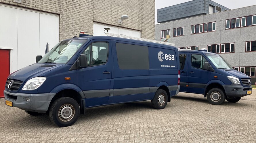
ESA’s navigation and telecommunications testbed vehicles are custom-built mobile test platforms operated by ESA’s Navigation Laboratory to support test campaigns for navigation and telecommunications services, most notably Europe’s Galileo constellation. Testing in the field provides a unique opportunity to complement laboratory tests, verifying the system’s performance from a user perspective in a more dynamic and realistic setting.
Upozornění
30.11.2023 9:15 ČÚZK - předpisy a opatření Katastrální úřad pro Plzeňský kraj - Katastrální pracoviště Domažlice zveřejnil novou aktualitu: Katastrální úřad pro Plzeňský kraj upozorňuje na změnu režimu v úhradách plateb správních poplatků v závěru roku 2023.Upozornění
30.11.2023 9:13 ČÚZK - předpisy a opatření Katastrální úřad pro Plzeňský kraj - Katastrální pracoviště Klatovy zveřejnil novou aktualitu: Katastrální úřad pro Plzeňský kraj upozorňuje na změnu režimu v úhradách plateb správních poplatků v závěru roku 2023.Upozornění
30.11.2023 9:11 ČÚZK - předpisy a opatření Katastrální úřad pro Plzeňský kraj - Katastrální pracoviště Kralovice zveřejnil novou aktualitu: Katastrální úřad pro Plzeňský kraj upozorňuje na změnu režimu v úhradách plateb správních poplatků v závěru roku 2023.Upozornění
30.11.2023 9:08 ČÚZK - předpisy a opatření Katastrální úřad pro Plzeňský kraj - Katastrální pracoviště Rokycany zveřejnil novou aktualitu: Katastrální úřad pro Plzeňský kraj upozorňuje na změnu režimu v úhradách plateb správních poplatků v závěru roku 2023.Upozornění
30.11.2023 9:05 ČÚZK - předpisy a opatření Katastrální úřad pro Plzeňský kraj - Katastrální pracoviště Tachov zveřejnil novou aktualitu: Katastrální úřad pro Plzeňský kraj upozorňuje na změnu režimu v úhradách plateb správních poplatků v závěru roku 2022.Upozornění
30.11.2023 9:05 ČÚZK - předpisy a opatření Katastrální úřad pro Plzeňský kraj - Katastrální pracoviště Tachov zveřejnil novou aktualitu: Katastrální úřad pro Plzeňský kraj upozorňuje na změnu režimu v úhradách plateb správních poplatků v závěru roku 2023.Odstávka dodávky elektrické energie
30.11.2023 6:57 ČÚZK - předpisy a opatření Katastrální úřad pro Jihočeský kraj - Katastrální pracoviště Jindřichův Hradec zveřejnil novou aktualitu: Dne 06.12.2023 v době od 08:00 – 15:00 hod. bude z důvodu přerušení dodávky elektrické energie na Katastrálním pracovišti Jindřichův Hradec omezen provoz.V této době nebude možno poskytovat na počkání informace z katastru nemovitostí a bude omezen také příjem podání:
- žádosti o informace z katastru budou přijímány pouze ve formě objednávek
- podání budou přijímána bez možnosti přidělení čísla jednacího
- správní poplatek půjde uhradit pouze ve formě kolkových známek nebo v hotovosti, příp. výzvou k úhradě převodem na účet. Nelze platit platební kartou.
Odstávka dodávky elektrické energie
30.11.2023 6:57 ČÚZK /Urady/Katastralni-urady/Katastralni-urady/Katastralni-urad-pro-Jihocesky-kraj/Katastralni-pracoviste/KP-Jindrichuv-Hradec/O-uradu/Aktuality/Odstavka-dodavky-elektricke-energieÚprava geoprocessingových služeb a aplikace Analýzy výškopisu
30.11.2023 6:30 ČÚZK - Geoportál Úprava geoprocessingových služeb a aplikace Analýzy výškopisuOddíl informací o Geoprocessingových službách byl aktualizován.
Geoprocessingové služby byly nahrazeny novými, počet služeb je výrazně nižší, protože nejsou publikovány pro každý model zvlášť, ale nově je rozlišuje parametr "Model".
Původní služby budou ponechány v provozu do 31. 12. 2023.
V aplikaci Analýzy výškopisu byly vzhledem k otevření dat Zeměměřického úřadu neveřejné nadstavbové služby nahrazeny veřejnými službami ZABAGED - polohopis a Geomorfologické jednotky.
Úprava geoprocessingových služeb a aplikace Analýzy výškopisu
30.11.2023 6:30 ČÚZK - Geoportál Úprava geoprocessingových služeb a aplikace Analýzy výškopisuOddíl informací o Geoprocessingových službách byl aktualizován.
Geoprocessingové služby byly nahrazeny novými, počet služeb je výrazně nižší, protože nejsou publikovány pro každý model zvlášť, ale nově je rozlišuje parametr "Model".
Původní služby budou ponechány v provozu do 31. 12. 2023.
V aplikaci Analýzy výškopisu byly vzhledem k otevření dat Zeměměřického úřadu neveřejné nadstavbové služby nahrazeny veřejnými službami ZABAGED - polohopis a Geomorfologické jednotky.
How will EarthCARE shed light on clouds?
29.11.2023 14:18 ESA Observing the Earth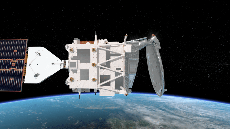
In around six months, ESA’s Earth Cloud Aerosol and Radiation Explorer mission will take to the skies to advance our understanding of the interactions between clouds, aerosols and radiation in Earth’s atmosphere. But how will it do that exactly?
Jak se používá geoinformatika v životním prostředí. Pozvánka na seminář
29.11.2023 12:53 GeoBusinessKatedra geoinformatiky Fakulty životního prostředí Univerzity Jana Evangelisty Purkyně v Ústí nad Labem zve na seminář Geoinformatika v životním prostředí. Akce se koná 6. ledna 2024. Témata budou zahrnovat využití široké škály geoinformatických nástrojů ve zkoumání různých aspektů životního prostředí, ať už z oblasti změn krajiny, ekosystémů a jejich funkcí či týkající se kulturně-historických aspektů […]
The post Jak se používá geoinformatika v životním prostředí. Pozvánka na seminář appeared first on GeoBusiness.
Jak se používá geoinformatika v životním prostředí. Pozvánka na seminář
29.11.2023 12:53 GeoBusiness Katedra geoinformatiky Fakulty životního prostředí Univerzity Jana Evangelisty Purkyně v Ústí nad Labem zve na seminář Geoinformatika v životním prostředí. Akce se koná 6. ledna 2024. Témata budou zahrnovat využití široké škály geoinformatických nástrojů ve zkoumání různých aspektů životního prostředí, ať už z oblasti změn krajiny, ekosystémů a jejich funkcí či týkající se kulturně-historických aspektů […]Odborný rada – vedoucí oddělení aktualizace KN
29.11.2023 10:37 ČÚZK /Urady/Katastralni-urady/Katastralni-urady/Katastralni-urad-pro-Karlovarsky-kraj/Uredni-deska/Oznameni-a-jina-uredni-sdeleni/Volna-mista/DMS/Odborny-rada-–-vedouci-oddeleni-aktualizace-KNOdborný rada – vedoucí oddělení aktualizace KN
29.11.2023 10:37 ČÚZK - volná místa Katastrální úřad pro Karlovarský kraj Katastrální pracoviště Cheb vypisuje výběrové řízení na místo Odborný rada – vedoucí oddělení aktualizace KNOdborný rada – vedoucí oddělení aktualizace KN
29.11.2023 10:37 ČÚZK - předpisy a opatření Katastrální úřad pro Karlovarský kraj Katastrální pracoviště Chebvypisuje výběrové řízení na místo
Odborný rada – vedoucí oddělení aktualizace KN
Odborný rada – vedoucí oddělení právních vztahů k nemovitostem
29.11.2023 10:34 ČÚZK - volná místa Katastrální úřad pro Karlovarský kraj Katastrální pracoviště Sokolov vypisuje výběrové řízení na místo Odborný rada – vedoucí oddělení právních vztahů k nemovitostemOdborný rada – vedoucí oddělení právních vztahů k nemovitostem
29.11.2023 10:34 ČÚZK /Urady/Katastralni-urady/Katastralni-urady/Katastralni-urad-pro-Karlovarsky-kraj/Uredni-deska/Oznameni-a-jina-uredni-sdeleni/Volna-mista/DMS/Odborny-rada-–-vedouci-oddeleni-pravnich-vztahu-k-Odborný rada – vedoucí oddělení právních vztahů k nemovitostem
29.11.2023 10:34 ČÚZK - předpisy a opatření Katastrální úřad pro Karlovarský kraj Katastrální pracoviště Sokolovvypisuje výběrové řízení na místo
Odborný rada – vedoucí oddělení právních vztahů k nemovitostem
Zveřejnění obsahu informací poskytnutých na žádost dle zákona č. 106/1999 Sb. za rok 2014
29.11.2023 10:16 ČÚZK /Urady/Zememericky-urad/Casto-hledane-informace/Poskytovani-informaci-106-1999-Sb/Zverejneni-obsahu-informaci-poskytnutych-na-za-(1)/Zverejneni-obsahu-informaci-poskytnutych-na-za-(7)Zveřejnění obsahu informací poskytnutých na žádost dle zákona č. 106/1999 Sb. za rok 2014
29.11.2023 10:16 Zeměměřický úřad Zeměměřický úřadzveřejňuje obsah informace poskytnutých na žádost dle zákona č. 106/1999 Sb. za rok
2014
Zveřejnění obsahu informací poskytnutých na žádost dle zákona č. 106/1999 Sb. za rok 2014
29.11.2023 10:16 ČÚZK - předpisy a opatření Zeměměřický úřadzveřejňuje obsah informace poskytnutých na žádost dle zákona č. 106/1999 Sb. za rok
2014
Zveřejnění obsahu informací poskytnutých na žádost dle zákona č. 106/1999 Sb. za rok 2014
29.11.2023 10:16 Zeměměřický úřad Zeměměřický úřadzveřejňuje obsah informace poskytnutých na žádost dle zákona č. 106/1999 Sb. za rok
2014
Zveřejnění obsahu informací poskytnutých na žádost dle zákona č. 106/1999 Sb. za rok 2013
29.11.2023 10:15 Zeměměřický úřad Zeměměřický úřadzveřejňuje obsah informace poskytnutých na žádost dle zákona č. 106/1999 Sb. za rok
2013
Zveřejnění obsahu informací poskytnutých na žádost dle zákona č. 106/1999 Sb. za rok 2013
29.11.2023 10:15 Zeměměřický úřad Zeměměřický úřadzveřejňuje obsah informace poskytnutých na žádost dle zákona č. 106/1999 Sb. za rok
2013
Zveřejnění obsahu informací poskytnutých na žádost dle zákona č. 106/1999 Sb. za rok 2013
29.11.2023 10:15 ČÚZK - předpisy a opatření Zeměměřický úřadzveřejňuje obsah informace poskytnutých na žádost dle zákona č. 106/1999 Sb. za rok
2013
Zveřejnění obsahu informací poskytnutých na žádost dle zákona č. 106/1999 Sb. za rok 2013
29.11.2023 10:15 ČÚZK /Urady/Zememericky-urad/Casto-hledane-informace/Poskytovani-informaci-106-1999-Sb/Zverejneni-obsahu-informaci-poskytnutych-na-za-(1)/Zverejneni-obsahu-informaci-poskytnutych-na-za-(6)The power of Earth observation
29.11.2023 10:00 ESA Observing the Earth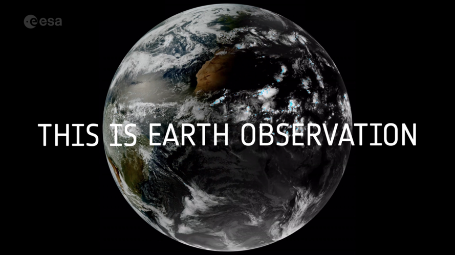 Video:
00:02:07
Video:
00:02:07
We are all intricately interconnected to our Earth – from the trees that provide us with oxygen, to the natural sources that shape our landscape. ESA's Earth observation programme is at the forefront of monitoring our planet's dynamic changes. Using cutting-edge satellite technology, ESA captures invaluable data on Earth's atmosphere, land and oceans. From tracking climate patterns to assessing environmental health, ESA's Earth observation initiatives provide essential insights for scientific research, environmental management and disaster response. By harnessing space technology, ESA contributes significantly to our understanding of Earth – ensuring a sustainable future for generations to come.
Zveřejnění obsahu informací poskytnutých na žádost dle zákona č. 106/1999 Sb. za rok 2019
29.11.2023 9:40 ČÚZK - předpisy a opatření Zeměměřický úřadzveřejňuje obsah informace poskytnutých na žádost dle zákona č. 106/1999 Sb. za rok
2019
Zveřejnění obsahu informací poskytnutých na žádost dle zákona č. 106/1999 Sb. za rok 2019
29.11.2023 9:40 Zeměměřický úřad Zeměměřický úřadzveřejňuje obsah informace poskytnutých na žádost dle zákona č. 106/1999 Sb. za rok
2019
Zveřejnění obsahu informací poskytnutých na žádost dle zákona č. 106/1999 Sb. za rok 2019
29.11.2023 9:40 ČÚZK /Urady/Zememericky-urad/Casto-hledane-informace/Poskytovani-informaci-106-1999-Sb/Zverejneni-obsahu-informaci-poskytnutych-na-za-(1)/Zverejneni-obsahu-informaci-poskytnutych-na-za-(5)Zveřejnění obsahu informací poskytnutých na žádost dle zákona č. 106/1999 Sb. za rok 2019
29.11.2023 9:40 Zeměměřický úřad Zeměměřický úřadzveřejňuje obsah informace poskytnutých na žádost dle zákona č. 106/1999 Sb. za rok
2019
Zveřejnění obsahu informací poskytnutých na žádost dle zákona č. 106/1999 Sb. za rok 2018
29.11.2023 9:40 ČÚZK - předpisy a opatření Zeměměřický úřadzveřejňuje obsah informace poskytnutých na žádost dle zákona č. 106/1999 Sb. za rok
2018
Zveřejnění obsahu informací poskytnutých na žádost dle zákona č. 106/1999 Sb. za rok 2018
29.11.2023 9:40 Zeměměřický úřad Zeměměřický úřadzveřejňuje obsah informace poskytnutých na žádost dle zákona č. 106/1999 Sb. za rok
2018
Zveřejnění obsahu informací poskytnutých na žádost dle zákona č. 106/1999 Sb. za rok 2018
29.11.2023 9:40 ČÚZK /Urady/Zememericky-urad/Casto-hledane-informace/Poskytovani-informaci-106-1999-Sb/Zverejneni-obsahu-informaci-poskytnutych-na-za-(1)/Zverejneni-obsahu-informaci-poskytnutych-na-za-(4)Zveřejnění obsahu informací poskytnutých na žádost dle zákona č. 106/1999 Sb. za rok 2018
29.11.2023 9:40 Zeměměřický úřad Zeměměřický úřadzveřejňuje obsah informace poskytnutých na žádost dle zákona č. 106/1999 Sb. za rok
2018
Zveřejnění obsahu informací poskytnutých na žádost dle zákona č. 106/1999 Sb. za rok 2016
29.11.2023 9:39 ČÚZK - předpisy a opatření Zeměměřický úřadzveřejňuje obsah informace poskytnutých na žádost dle zákona č. 106/1999 Sb. za rok
2016
Zveřejnění obsahu informací poskytnutých na žádost dle zákona č. 106/1999 Sb. za rok 2016
29.11.2023 9:39 Zeměměřický úřad Zeměměřický úřadzveřejňuje obsah informace poskytnutých na žádost dle zákona č. 106/1999 Sb. za rok
2016
Zveřejnění obsahu informací poskytnutých na žádost dle zákona č. 106/1999 Sb. za rok 2016
29.11.2023 9:39 Zeměměřický úřad Zeměměřický úřadzveřejňuje obsah informace poskytnutých na žádost dle zákona č. 106/1999 Sb. za rok
2016
Zveřejnění obsahu informací poskytnutých na žádost dle zákona č. 106/1999 Sb. za rok 2016
29.11.2023 9:39 ČÚZK /Urady/Zememericky-urad/Casto-hledane-informace/Poskytovani-informaci-106-1999-Sb/Zverejneni-obsahu-informaci-poskytnutych-na-za-(1)/Zverejneni-obsahu-informaci-poskytnutych-na-za-(3)DTM – Historie technické mapy v Praze (kniha)
29.11.2023 9:30 GISportal.cz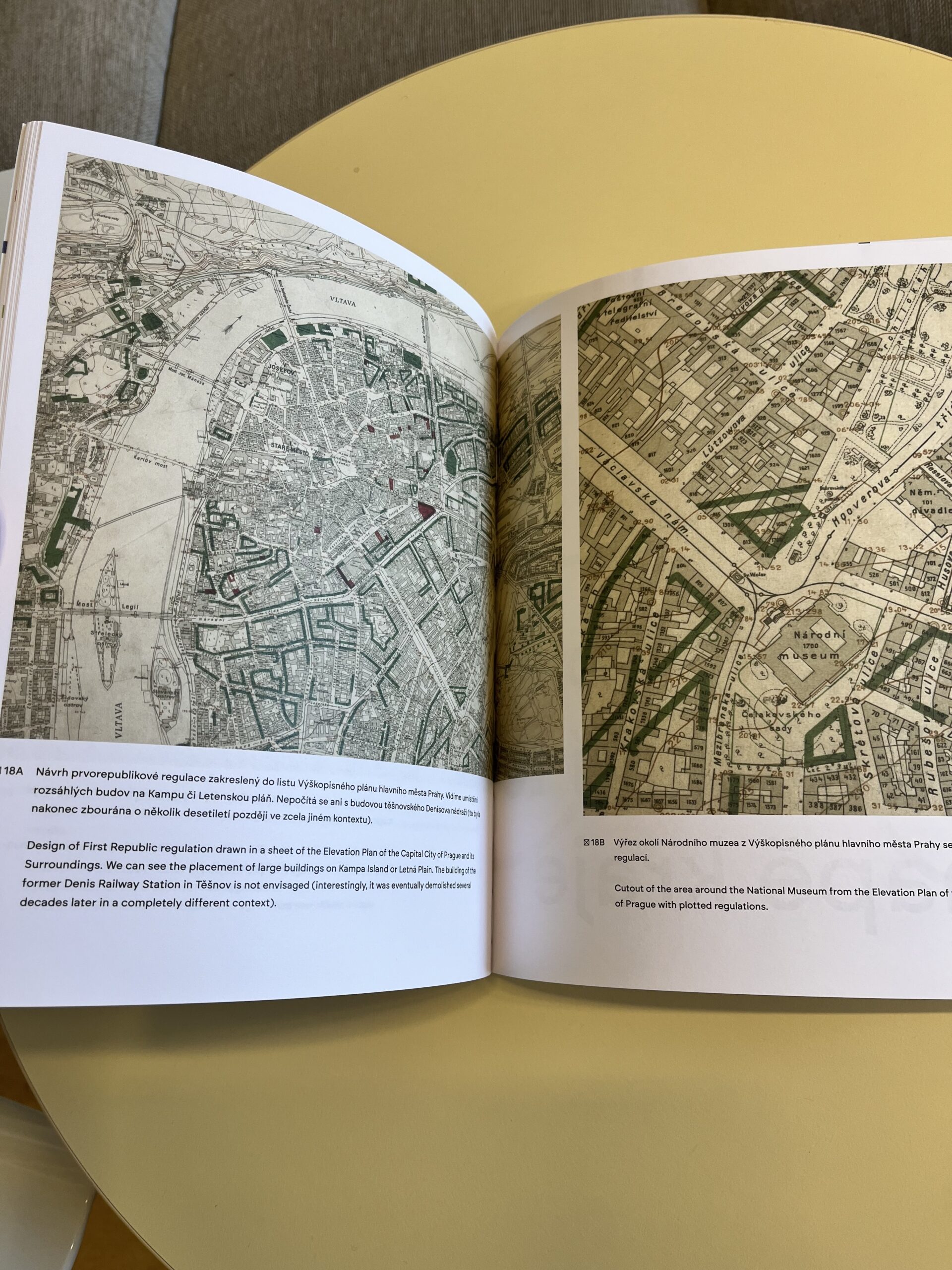
Institut plánování a rozvoje hlavního města Prahy (IPR Praha) vydal ve spolupráci s dalšími autory velice krásnou publikaci DTM – Historie technické mapy v Praze, která přehledně shrnuje vývoj mapování velkých měřítek na území hlavního města od prvních geodetických plánů konce 18. století až po současné digitální technické mapy. Řada grafických zobrazení dokumentuje vývoj obsahu […]
The post DTM – Historie technické mapy v Praze (kniha) appeared first on GISportal.cz.
27. světový silniční kongres, tam jsme nemohli chybět
29.11.2023 7:42 Hrdlička Po 52 letech se vrátila výjimečná událost zpět do České republiky.Vizualizace historických vodojemů v Brně
29.11.2023 7:28 Hrdlička Díky moderním technologiím „navštívíte“ památky i z domovaČKZ: Kandidáti do orgánů komory – přehledka
28.11.2023 22:12 ZeměměřičZájem o činnost v prvních orgánech České komory zeměměřičů projevilo do 27. listopadu celkem 54 kandidátů. Do prvního období činnosti na roky 2024 až 2026 se do představenstva hlásí 17 kandidátů, z nichž budou členové vybírat 7 členů a 2 náhradníky. Do dozorčí rady je přihlášeno 16 kandidátů, vybírat se bude 5 členů a 2 náhradníci. Do stavovského soudu se přihlásilo […]
The post ČKZ: Kandidáti do orgánů komory – přehledka appeared first on Zeměměřič.
ČKZ: Program ustavujícího sněmu komory 11. prosince
28.11.2023 21:53 ZeměměřičPřípravný výbor České komory zeměměřičů svolal na 11. prosince 2023 ustavující sněm České komory zeměměřičů. Vzhledem k počtu účastníků komory se sněm bude konat v kongresovém hotelu Clarion Congress Hotel Prague (Freyova 33, Praha 9 – Vysočany) Prezence účastníků ustavujícího sněmu bude probíhat od 8 do 10:00 hodin – prezenční seznamy budou řazeny podle čísla oprávnění autorizovaného zeměměřického […]
The post ČKZ: Program ustavujícího sněmu komory 11. prosince appeared first on Zeměměřič.
Warming ocean causing rapid glacier retreat
28.11.2023 17:00 ESA Observing the Earth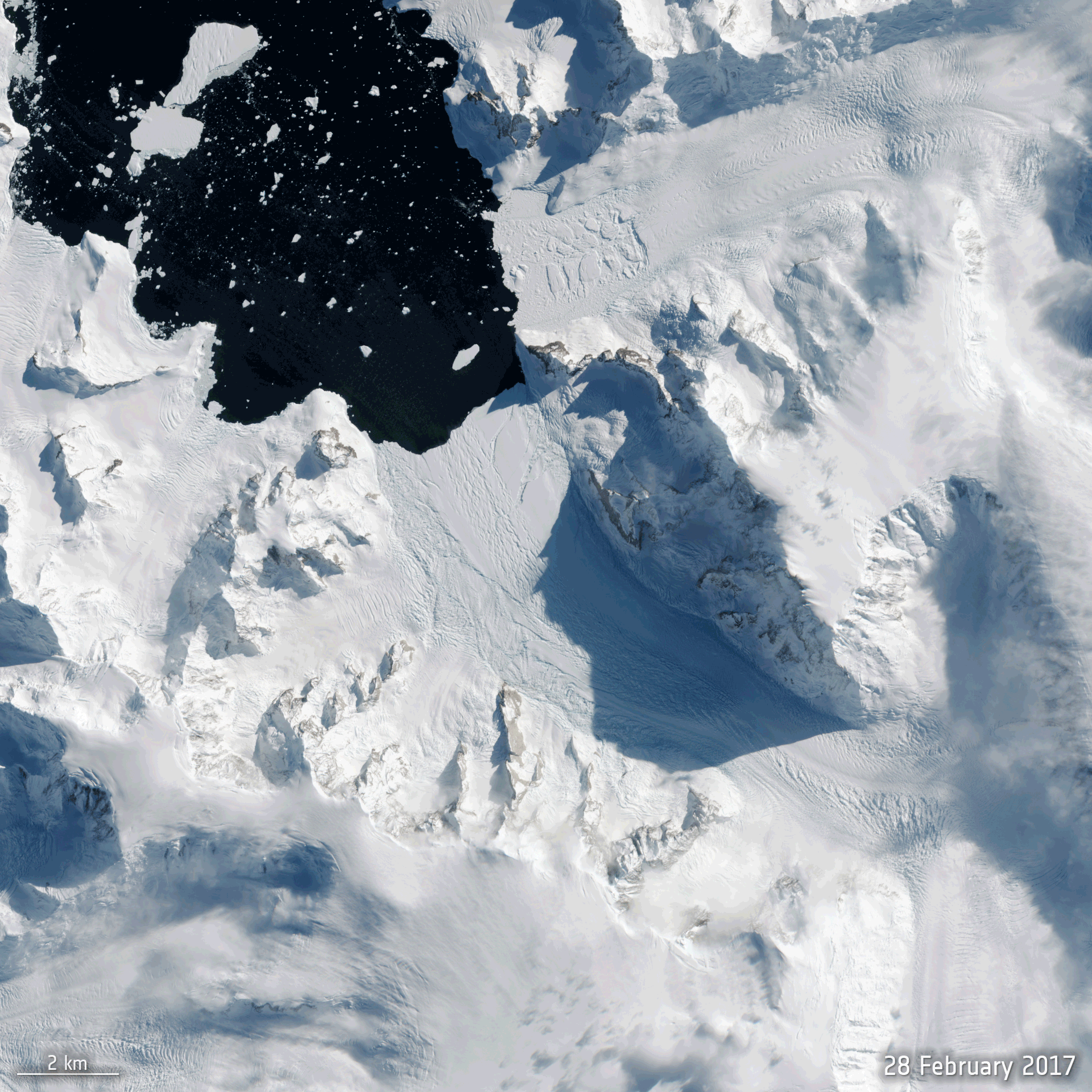
With all eyes about to focus on the COP28 climate conference in Dubai, new scientific findings show, again, that the climate crisis is taking its toll on Antarctica – a continent, up to recently, thought better able to withstand the immediate effects of rising global temperatures.
Using satellite data, scientists have discovered that the ice shelf extending into the ocean from Cadman Glacier on the west Antarctic Peninsula collapsed, leaving the glacier exposed to unusually warm ocean water, which caused the glacier to accelerate and retreat rapidly.
Zveřejnění obsahu informací poskytnutých na žádost dle zákona č. 106/1999 Sb. za rok 2020
28.11.2023 14:10 Zeměměřický úřad Zeměměřický úřadzveřejňuje obsah informace poskytnutých na žádost dle zákona č. 106/1999 Sb. za rok
2020
Zveřejnění obsahu informací poskytnutých na žádost dle zákona č. 106/1999 Sb. za rok 2020
28.11.2023 14:10 Zeměměřický úřad Zeměměřický úřadzveřejňuje obsah informace poskytnutých na žádost dle zákona č. 106/1999 Sb. za rok
2020
Zveřejnění obsahu informací poskytnutých na žádost dle zákona č. 106/1999 Sb. za rok 2020
28.11.2023 14:10 ČÚZK - předpisy a opatření Zeměměřický úřadzveřejňuje obsah informace poskytnutých na žádost dle zákona č. 106/1999 Sb. za rok
2020
Zveřejnění obsahu informací poskytnutých na žádost dle zákona č. 106/1999 Sb. za rok 2020
28.11.2023 14:10 ČÚZK /Urady/Zememericky-urad/Casto-hledane-informace/Poskytovani-informaci-106-1999-Sb/Zverejneni-obsahu-informaci-poskytnutych-na-za-(1)/Zverejneni-obsahu-informaci-poskytnutych-na-za-(2)20231128_Odborný / vrchní referent oddělení aktualizace PI KN I.
28.11.2023 13:54 ČÚZK - předpisy a opatření Katastrální úřad pro Středočeský kraj - Katastrální pracoviště Praha-západ Vyhlášení výběrového řízení: Odborný / vrchní referent oddělení aktualizace PI KN I. V části "Úřední deska", v sekci "Oznámení a jiná úřední sdělení" bylo vystaveno "Oznámení o vyhlášení výběrového řízení na obsazení služebního místa Odborný / vrchní referent oddělení aktualizace PI KN I."20231128_Odborný / vrchní referent oddělení aktualizace PI KN I.
28.11.2023 13:54 ČÚZK /Urady/Katastralni-urady/Katastralni-urady/Katastralni-urad-pro-Stredocesky-kraj/Katastralni-pracoviste/KP-Praha-zapad/O-uradu/Aktuality/20210922_Odborny-referent-oddeleni-aktualizac-(8)Zveřejnění obsahu informací poskytnutých na žádost dle zákona č. 106/1999 Sb. za rok 2021
28.11.2023 13:53 ČÚZK - předpisy a opatření Zeměměřický úřadzveřejňuje obsah informace poskytnutých na žádost dle zákona č. 106/1999 Sb. za rok
2021
Zveřejnění obsahu informací poskytnutých na žádost dle zákona č. 106/1999 Sb. za rok 2021
28.11.2023 13:53 Zeměměřický úřad Zeměměřický úřadzveřejňuje obsah informace poskytnutých na žádost dle zákona č. 106/1999 Sb. za rok
2021
Zveřejnění obsahu informací poskytnutých na žádost dle zákona č. 106/1999 Sb. za rok 2021
28.11.2023 13:53 ČÚZK /Urady/Zememericky-urad/Casto-hledane-informace/Poskytovani-informaci-106-1999-Sb/Zverejneni-obsahu-informaci-poskytnutych-na-za-(1)/Zverejneni-obsahu-informaci-poskytnutych-na-za-(1)Zveřejnění obsahu informací poskytnutých na žádost dle zákona č. 106/1999 Sb. za rok 2021
28.11.2023 13:53 Zeměměřický úřad Zeměměřický úřadzveřejňuje obsah informace poskytnutých na žádost dle zákona č. 106/1999 Sb. za rok
2021
Zveřejnění obsahu informací poskytnutých na žádost dle zákona č. 106/1999 Sb. za rok 2022
28.11.2023 13:52 ČÚZK - předpisy a opatření Zeměměřický úřadzveřejňuje obsah informace poskytnutých na žádost dle zákona č. 106/1999 Sb. za rok
2022
Zveřejnění obsahu informací poskytnutých na žádost dle zákona č. 106/1999 Sb. za rok 2022
28.11.2023 13:52 Zeměměřický úřad Zeměměřický úřadzveřejňuje obsah informace poskytnutých na žádost dle zákona č. 106/1999 Sb. za rok
2022
Zveřejnění obsahu informací poskytnutých na žádost dle zákona č. 106/1999 Sb. za rok 2022
28.11.2023 13:52 Zeměměřický úřad Zeměměřický úřadzveřejňuje obsah informace poskytnutých na žádost dle zákona č. 106/1999 Sb. za rok
2022
Zveřejnění obsahu informací poskytnutých na žádost dle zákona č. 106/1999 Sb. za rok 2022
28.11.2023 13:52 ČÚZK /Urady/Zememericky-urad/Casto-hledane-informace/Poskytovani-informaci-106-1999-Sb/Zverejneni-obsahu-informaci-poskytnutych-na-za-(1)/Zverejneni-obsahu-informaci-poskytnutych-na-zadostVýroční zpráva dle zákona č. 106/1999 Sb. za rok 2019
28.11.2023 13:26 Zeměměřický úřad Zeměměřický úřadvydává výroční zprávu úřadu za rok
2019
Výroční zpráva dle zákona č. 106/1999 Sb. za rok 2022
28.11.2023 13:26 Zeměměřický úřad Zeměměřický úřadvydává výroční zprávu úřadu za rok
2022
Výroční zpráva dle zákona č. 106/1999 Sb. za rok 2019
28.11.2023 13:26 ČÚZK /Urady/Zememericky-urad/Casto-hledane-informace/Poskytovani-informaci-106-1999-Sb/Vyrocni-zpravy-dle-zakona-c-106-1999-Sb/Vyrocni-zprava-ZU-dle-zakona-c-106-1999-Sb/Vyrocni-zprava-dle-zakona-c-106-1999-Sb-za-rok-(1)Výroční zpráva dle zákona č. 106/1999 Sb. za rok 2019
28.11.2023 13:26 ČÚZK - předpisy a opatření Zeměměřický úřadvydává výroční zprávu úřadu za rok
2019
Výroční zpráva dle zákona č. 106/1999 Sb. za rok 2022
28.11.2023 13:26 ČÚZK /Urady/Zememericky-urad/Casto-hledane-informace/Poskytovani-informaci-106-1999-Sb/Vyrocni-zpravy-dle-zakona-c-106-1999-Sb/Vyrocni-zprava-ZU-dle-zakona-c-106-1999-Sb/Vyrocni-zprava-dle-zakona-c-106-1999-Sb-za-rok-202Výroční zpráva dle zákona č. 106/1999 Sb. za rok 2022
28.11.2023 13:26 ČÚZK - předpisy a opatření Zeměměřický úřadvydává výroční zprávu úřadu za rok
2022
Výroční zpráva dle zákona č. 106/1999 Sb. za rok 2019
28.11.2023 13:26 Zeměměřický úřad Zeměměřický úřadvydává výroční zprávu úřadu za rok
2019
Výroční zpráva dle zákona č. 106/1999 Sb. za rok 2022
28.11.2023 13:26 Zeměměřický úřad Zeměměřický úřadvydává výroční zprávu úřadu za rok
2022
2012
28.11.2023 13:26 ČÚZK /Urady/Zememericky-urad/Casto-hledane-informace/Poskytovani-informaci-106-1999-Sb/Vyrocni-zpravy-dle-zakona-c-106-1999-Sb/Vyrocni-zprava-ZU-dle-zakona-c-106-1999-Sb/20122013
28.11.2023 13:26 ČÚZK /Urady/Zememericky-urad/Casto-hledane-informace/Poskytovani-informaci-106-1999-Sb/Vyrocni-zpravy-dle-zakona-c-106-1999-Sb/Vyrocni-zprava-ZU-dle-zakona-c-106-1999-Sb/2013Výroční zpráva dle zákona č. 106/1999 Sb. za rok 20
28.11.2023 13:26 ČÚZK /Urady/Zememericky-urad/Casto-hledane-informace/Poskytovani-informaci-106-1999-Sb/Vyrocni-zpravy-dle-zakona-c-106-1999-Sb/Vyrocni-zprava-ZU-dle-zakona-c-106-1999-Sb/Vyrocni-zprava-dle-zakona-c-106-1999-Sb-za-rok-(2)2016
28.11.2023 13:26 ČÚZK - předpisy a opatření Zeměměřický úřadvydává výroční zprávu úřadu za rok
2016
Výroční zpráva dle zákona č. 106/1999 Sb. za rok 20
28.11.2023 13:26 Zeměměřický úřad Zeměměřický úřadvydává výroční zprávu úřadu za rok
2020
2017
28.11.2023 13:26 ČÚZK /Urady/Zememericky-urad/Casto-hledane-informace/Poskytovani-informaci-106-1999-Sb/Vyrocni-zpravy-dle-zakona-c-106-1999-Sb/Vyrocni-zprava-ZU-dle-zakona-c-106-1999-Sb/20172017
28.11.2023 13:26 ČÚZK - předpisy a opatření Zeměměřický úřadvydává výroční zprávu úřadu za rok
2017
Výroční zpráva dle zákona č. 106/1999 Sb. za rok 20
28.11.2023 13:26 Zeměměřický úřad Zeměměřický úřadvydává výroční zprávu úřadu za rok
2021
2010
28.11.2023 13:26 ČÚZK /Urady/Zememericky-urad/Casto-hledane-informace/Poskytovani-informaci-106-1999-Sb/Vyrocni-zpravy-dle-zakona-c-106-1999-Sb/Vyrocni-zprava-ZU-dle-zakona-c-106-1999-Sb/20102015
28.11.2023 13:26 ČÚZK /Urady/Zememericky-urad/Casto-hledane-informace/Poskytovani-informaci-106-1999-Sb/Vyrocni-zpravy-dle-zakona-c-106-1999-Sb/Vyrocni-zprava-ZU-dle-zakona-c-106-1999-Sb/2015Výroční zpráva dle zákona č. 106/1999 Sb. za rok 2018
28.11.2023 13:26 ČÚZK - předpisy a opatření Zeměměřický úřadvydává výroční zprávu úřadu za rok
2018
Výroční zpráva dle zákona č. 106/1999 Sb. za rok 20
28.11.2023 13:26 ČÚZK - předpisy a opatření Zeměměřický úřadvydává výroční zprávu úřadu za rok
2020
Výroční zpráva dle zákona č. 106/1999 Sb. za rok 2018
28.11.2023 13:26 Zeměměřický úřad Zeměměřický úřadvydává výroční zprávu úřadu za rok
2018
2014
28.11.2023 13:26 ČÚZK /Urady/Zememericky-urad/Casto-hledane-informace/Poskytovani-informaci-106-1999-Sb/Vyrocni-zpravy-dle-zakona-c-106-1999-Sb/Vyrocni-zprava-ZU-dle-zakona-c-106-1999-Sb/2014Výroční zpráva dle zákona č. 106/1999 Sb. za rok 20
28.11.2023 13:26 ČÚZK /Urady/Zememericky-urad/Casto-hledane-informace/Poskytovani-informaci-106-1999-Sb/Vyrocni-zpravy-dle-zakona-c-106-1999-Sb/Vyrocni-zprava-ZU-dle-zakona-c-106-1999-Sb/Vyrocni-zprava-dle-zakona-c-106-1999-Sb-za-rok-(3)Výroční zpráva dle zákona č. 106/1999 Sb. za rok 20
28.11.2023 13:26 ČÚZK - předpisy a opatření Zeměměřický úřadvydává výroční zprávu úřadu za rok
2021