


![]()

zprávy
zdroje zpráv:EDG²E and the optimisation of aviation navigation with Galileo
23.6.2023 17:18 European GNSS Agency
The EU-funded project, EDG2E, managed by the European Union Agency for the Space Programme made significant strides in optimizing aviation navigation with the integration of Galileo, the European GNSS system. By leveraging the advanced capabilities of Galileo and incorporating them into avionics technology, the project aims to enhance safety, precision, and reliability in air travel, ultimately benefiting the aviation industry as a whole.
The project has recently demonstrated the capabilities of the new DFMC Navigation modes using GPS + Galileo in the L1/L5 and E1/E5a frequencies. The DFMC Navigation modes showcased their functionality under various flight plans, including different latitudes and approaches such as RNP (Required Navigation Performance). The tests were conducted using a prototype avionic GNSS Receiver using high reliability hardware components in design. Realistic installation conditions were simulated on an ATR72-600 aircraft, considering installation constraints like DFMC antenna characteristics, analog front end architecture device losses, and the effects of vibrations and dynamic factors.
The EDG2E project, and the MUGG project, stand out as the only initiatives to achieve successful proof of concept through flight trials, even in scenarios with a limited number of GPS L1/L5 satellites available. This achievement has not impeded the project's ability to accomplish RNP0.1 and RNP0.3 operations, demonstrating its robustness and effectiveness.
One of the other key outcomes of the EDG2E project is the validation and consolidation of the DFMC SBAS MOPS (Minimum Operational Performance Standards) identified as EUROCAE ED-259A / RTCA DO-401. This provides a concrete means to advance and refine the receiver standard, paving the way for improved aviation navigation systems.
A webinar is now being organised to learn more about the advancements made by the EDG2E project, and discuss further the achievements in aviation navigation optimization. The webinar aims to accomplish several objectives:
- Present Galileo and EGNOS V3, highlighting the specific advantages they offer to the aviation industry. This will provide attendees with valuable insights into the potential benefits of integrating these programs into aviation navigation systems.
- Showcase the EDG2E project and share the outcomes of the recently completed flight trials using the prototype receiver that tested DFMC Navigation modes.
- Engage the audience in a discussion about the advantages of the SBAS DFMC receiver for aviation. Attendees will have the opportunity to provide feedback and share their perspectives on the benefits of this technology.
- Present the results of a questionnaire posted on the project website, further enriching the understanding of the receiver's potential impact.
The webinar will provide a platform to disseminate the results and discuss their implications for the aviation sector providing confidence among stakeholders regarding the imminent availability of DFMC signals and receivers in aviation.
Join us here.
Media note: This feature can be republished without charge provided the European Union Agency for the Space Programme (EUSPA) is acknowledged as the source at the top or the bottom of the story. You must request permission before you use any of the photographs on the site. If you republish, we would be grateful if you could link back to the EUSPA website (http://www.euspa.europa.eu).
EDG²E and the optimisation of aviation navigation with Galileo
23.6.2023 17:18 European GNSS AgencyThe EU-funded project, EDG2E, managed by the European Union Agency for the Space Programme made significant strides in optimizing aviation navigation with the integration of Galileo, the European GNSS system. By leveraging the advanced capabilities of Galileo and incorporating them into avionics technology, the project aims to enhance safety, precision, and reliability in air travel, ultimately benefiting the aviation industry as a whole.
The project has recently demonstrated the capabilities of the new DFMC Navigation modes using GPS + Galileo in the L1/L5 and E1/E5a frequencies. The DFMC Navigation modes showcased their functionality under various flight plans, including different latitudes and approaches such as RNP (Required Navigation Performance). The tests were conducted using a prototype avionic GNSS Receiver using high reliability hardware components in design. Realistic installation conditions were simulated on an ATR72-600 aircraft, considering installation constraints like DFMC antenna characteristics, analog front end architecture device losses, and the effects of vibrations and dynamic factors.
The EDG2E project, and the MUGG project, stand out as the only initiatives to achieve successful proof of concept through flight trials, even in scenarios with a limited number of GPS L1/L5 satellites available. This achievement has not impeded the project's ability to accomplish RNP0.1 and RNP0.3 operations, demonstrating its robustness and effectiveness.
One of the other key outcomes of the EDG2E project is the validation and consolidation of the DFMC SBAS MOPS (Minimum Operational Performance Standards) identified as EUROCAE ED-259A / RTCA DO-401. This provides a concrete means to advance and refine the receiver standard, paving the way for improved aviation navigation systems.
A webinar is now being organised to learn more about the advancements made by the EDG2E project, and discuss further the achievements in aviation navigation optimization. The webinar aims to accomplish several objectives:
- Present Galileo and EGNOS V3, highlighting the specific advantages they offer to the aviation industry. This will provide attendees with valuable insights into the potential benefits of integrating these programs into aviation navigation systems.
- Showcase the EDG2E project and share the outcomes of the recently completed flight trials using the prototype receiver that tested DFMC Navigation modes.
- Engage the audience in a discussion about the advantages of the SBAS DFMC receiver for aviation. Attendees will have the opportunity to provide feedback and share their perspectives on the benefits of this technology.
- Present the results of a questionnaire posted on the project website, further enriching the understanding of the receiver's potential impact.
The webinar will provide a platform to disseminate the results and discuss their implications for the aviation sector providing confidence among stakeholders regarding the imminent availability of DFMC signals and receivers in aviation.
Join us here.
Media note: This feature can be republished without charge provided the European Union Agency for the Space Programme (EUSPA) is acknowledged as the source at the top or the bottom of the story. You must request permission before you use any of the photographs on the site. If you republish, we would be grateful if you could link back to the EUSPA website (http://www.euspa.europa.eu).
Účastnili jsme se aktivně U-space workshopu v EASA v Kolíně nad Rýnem
23.6.2023 15:27 UAVAÚčastnili jsme se aktivně dvoudenního workshopu k U-space v centrále EASA v Kolíně nad Rýnem. Celá podrobná prezentace a videozáznam workshopu je k dispozici na stránkách EASA zde: https://www.easa.europa.eu/en/newsroom-and-events/events/u-space-workshop-concept-implementation
The post Účastnili jsme se aktivně U-space workshopu v EASA v Kolíně nad Rýnem appeared first on UAV Aliance pro bezpilotní letecký průmysl.
EduChange 2.0 konference v Utrechtu
23.6.2023 14:31 GISportal.cz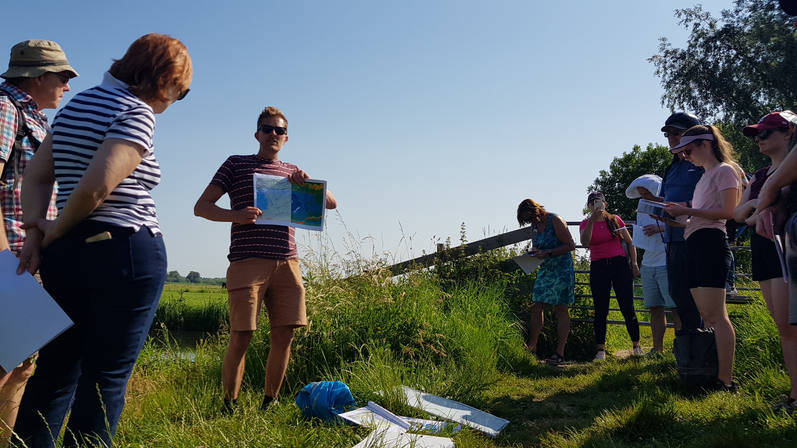
Ve dnech 15.–16. června 2023 proběhla EduChange 2.0 konference pro učitele, studenty a kohokoli, kdo se zajímají o inovativní formu výuky o environmentálních výzvách. Hlavní pozornost se zde soustředila na terénní výuku a aplikace, které je pro ni možné využít. Konference probíhala ve dvou dnech, kdy první byla exkurze na kolech v okolí města Gouda a […]
The post EduChange 2.0 konference v Utrechtu appeared first on GISportal.cz.
EduChange 2.0 konference v Utrechtu
23.6.2023 14:31 GISportal.czVe dnech 15.–16. června 2023 proběhla EduChange 2.0 konference pro učitele, studenty a kohokoli, kdo se zajímají o inovativní formu výuky o environmentálních výzvách. Hlavní pozornost se zde soustředila na terénní výuku a aplikace, které je pro ni možné využít. Konference probíhala ve dvou dnech, kdy první byla exkurze na kolech v okolí města Gouda a […]
The post EduChange 2.0 konference v Utrechtu appeared first on GISportal.cz.
India Joins buildingSMART International as a Developing Chapter
23.6.2023 12:09 buildingSMART.orgLondon, (June 20, 2023) – buildingSMART International is pleased to announce that India has been formally approved as a “Developing Chapter” by the Board at the International Council and Chapter Conference…
The post India Joins buildingSMART International as a Developing Chapter appeared first on buildingSMART International.
India Joins buildingSMART International as a Developing Chapter
23.6.2023 12:09 buildingSMART.orgLondon, (June 20, 2023) – buildingSMART International is pleased to announce that bSI-India under Confederation of Digital Construction Practitioners India (CDCPIndia) has been formally approved as a “Developing Chapter” by…
The post India Joins buildingSMART International as a Developing Chapter appeared first on buildingSMART International.
Earth from Space: Tashkent, Uzbekistan
23.6.2023 10:00 ESA Observing the Earth Image:
The Copernicus Sentinel-2 mission takes us over Tashkent, the capital city of Uzbekistan.
Image:
The Copernicus Sentinel-2 mission takes us over Tashkent, the capital city of Uzbekistan.
Nový 3D skener Trimble X9
23.6.2023 9:50 Geotronics3D laserový skenovací systém Trimble X9. Vybaven skenovacími technologiemi Trimble, které zahrnují automatickou kalibraci přístroje, automatickou horizontaci a laserovou stopu pro georeferencování.
The post Nový 3D skener Trimble X9 first appeared on GEOTRONICS Praha.
Nový 3D skener Trimble MX9
23.6.2023 9:50 Geotronics3D laserový skenovací systém Trimble X9. Vybaven skenovacími technologiemi Trimble, které zahrnují automatickou kalibraci přístroje, automatickou horizontaci a laserovou stopu pro georeferencování.
The post Nový 3D skener Trimble MX9 first appeared on GEOTRONICS Praha.
Nový 3D skener Trimble X9
23.6.2023 9:50 Geotronics3D laserový skenovací systém Trimble X9. Vybaven skenovacími technologiemi Trimble, které zahrnují automatickou kalibraci přístroje, automatickou horizontaci a laserovou stopu pro georeferencování.
The post Nový 3D skener Trimble X9 first appeared on GEOTRONICS Praha.
Nasazení JVF DTM 1.4.2.3 na INT1
22.6.2023 16:24 ČÚZK - předpisy a opatření Český úřad zeměměřický a katastrální v souladu s předchozími informacemi upozorňuje, že nová verze JVF DTM 1.4.2.3 bude v termínu od 1. července 2023 nasazena také na integračním prostředí INT1 IS DMVS. Její dokumentace byla již dříve vystavena do záložky JVF DTM.Otevírací doba v pátek 7.7.2023
22.6.2023 15:05 GEUSware Pá 7.7.2023: ZAVŘENO - z personálních důvodů. Mimo provoz je i technická podpora.20230622 - Změny VFK v nové verzi ISKN 10.0
22.6.2023 14:56 ČÚZK - Výměnný formát ISKN V souvislosti s instalací nové verze ISKN 10.0 dojde ke změně ve struktuře výměnného formátu ISKN. Nová verze ponese označení 6.1. Předpokládaný termín instalace je 25.8.202320230622 - Změny VFK v nové verzi ISKN 10.0
22.6.2023 14:56 ČÚZK - Výměnný formát ISKN V souvislosti s instalací nové verze ISKN 10.0 dojde ke změně ve struktuře výměnného formátu ISKN. Nová verze ponese označení 6.1. Předpokládaný termín instalace je 25.8.202320230622 - Změny VFK v nové verzi ISKN 10.0
22.6.2023 14:56 ČÚZK - předpisy a opatření V souvislosti s instalací nové verze ISKN 10.0 dojde ke změně ve struktuře výměnného formátu ISKN. Nová verze ponese označení 6.1. Předpokládaný termín instalace je 25.8.202320230622 - Změny VFK v nové verzi ISKN 10.0
22.6.2023 14:56 ČÚZK - Výměnný formát ISKN V souvislosti s instalací nové verze ISKN 10.0 dojde ke změně ve struktuře výměnného formátu ISKN. Nová verze ponese označení 6.1. Předpokládaný termín instalace je 25.8.202320230622 - Změny VFK v nové verzi ISKN 10.0
22.6.2023 14:56 ČÚZK - Výměnný formát ISKN V souvislosti s instalací nové verze ISKN 10.0 dojde ke změně ve struktuře výměnného formátu ISKN. Nová verze ponese označení 6.1. Předpokládaný termín instalace je 25.8.202320230622 - Změny VFK v nové verzi ISKN 10.0
22.6.2023 14:56 ČÚZK - Výměnný formát ISKN V souvislosti s instalací nové verze ISKN 10.0 dojde ke změně ve struktuře výměnného formátu ISKN. Nová verze ponese označení 6.1. Předpokládaný termín instalace je 25.8.202320230622 - Změny VFK v nové verzi ISKN 10.0
22.6.2023 14:56 ČÚZK - Výměnný formát ISKN V souvislosti s instalací nové verze ISKN 10.0 dojde ke změně ve struktuře výměnného formátu ISKN. Nová verze ponese označení 6.1. Předpokládaný termín instalace je 25.8.202320230622 - Změny VFK v nové verzi ISKN 10.0
22.6.2023 14:56 ČÚZK - předpisy a opatření V souvislosti s instalací nové verze ISKN 10.0 dojde ke změně ve struktuře výměnného formátu ISKN. Nová verze ponese označení 6.1. Předpokládaný termín instalace je 25.8.2023Změny VFK v nové verzi ISKN 10.0
22.6.2023 14:56 ČÚZK - Výměnný formát ISKN V souvislosti s instalací nové verze ISKN 10.0 dojde ke změně ve struktuře výměnného formátu ISKN. Nová verze ponese označení 6.1. Předpokládaný termín instalace je 25.8.2023Popis změn a ukázkový soubor VFK ve formátu ZIP
Paris Air Show Live – Session on understanding Earth’s water and carbon cycles from space
22.6.2023 13:30 ESA Observing the Earth Video:
01:08:04
Video:
01:08:04
By using concrete examples of the water and carbon cycles, the speakers in this session focus on the grand science questions and how we can turn them into answers and solutions most useful to decision-makers at the front line of the climate crisis. Earth is a highly dynamic system where the transport and exchanges of energy and matter are influenced by a multitude of processes and feedback mechanisms. Untangling these complex processes to better understand how Earth works as a system is a major challenge; a challenge that satellites, with their global view, are ideally positioned to tackle. While each mission gives us unique insights, it is by combining their data that makes scientific findings shine the brightest. This, in turn, puts European and international collaboration at the heart of Earth observation today.
Kartograf/ka
22.6.2023 7:55 ČÚZK /Urady/Zememericky-urad/Uredni-deska/Oznameni-a-jina-uredni-sdeleni/Volna-mista/DMS/Kartograf-kaKartograf/ka
22.6.2023 7:55 Zeměměřický úřad Zeměměřický úřadvypisuje výběrové řízení na místo
Kartograf/ka
Kartograf/ka
22.6.2023 7:55 ČÚZK - volná místa Zeměměřický úřad vypisuje výběrové řízení na místo Kartograf/kaKartograf/ka
22.6.2023 7:55 ČÚZK - předpisy a opatření Zeměměřický úřadvypisuje výběrové řízení na místo
Kartograf/ka
National Institute of Building Sciences and buildingSMART International Sign Agreement to Support Open Standards
21.6.2023 19:46 buildingSMART.orgThe goal is to mutually support the digital transformation of the U.S. and global construction industry (London, June 20, 2023) – The National Institute of Building Sciences (NIBS) and buildingSMART…
The post National Institute of Building Sciences and buildingSMART International Sign Agreement to Support Open Standards appeared first on buildingSMART International.
buildingSMART International completes its first project under the Accelerator Program
21.6.2023 19:05 buildingSMART.orgLondon, U.K. - June 21, 2023 - London, - buildingSMART International (bSI) is delighted to announce the completion of the first "Accelerator Program" project with Mott MacDonald to…
The post buildingSMART International completes its first project under the Accelerator Program appeared first on buildingSMART International.
Přerušení služeb DP a WSDP
21.6.2023 16:13 GEPROVe čtvrtek 22. 6. 2023 v době od 16:30 do cca 18 hodin ČÚZK zcela přeruší provoz Dálkového přístupu a Webových služeb dálkového přístupu. Své aktivity využívající těchto služeb proto přizpůsobte této situaci.
Článek Přerušení služeb DP a WSDP se nejdříve objevil na GEPRO.
30. slovenské geodetické dni
21.6.2023 14:40 Komora geodetů a kartografů SRThe post 30. slovenské geodetické dni appeared first on Komora geodetov a kartografov.
Vedoucí oddělení digitální kartografie II
21.6.2023 14:35 Zeměměřický úřad Zeměměřický úřadvypisuje výběrové řízení na místo
Vedoucí oddělení digitální kartografie II
Vedoucí oddělení digitální kartografie II
21.6.2023 14:35 ČÚZK /Urady/Zememericky-urad/Uredni-deska/Oznameni-a-jina-uredni-sdeleni/Volna-mista/DMS/Vedouci-oddeleni-digitalni-kartografie-IIVedoucí oddělení digitální kartografie II
21.6.2023 14:35 ČÚZK - předpisy a opatření Zeměměřický úřadvypisuje výběrové řízení na místo
Vedoucí oddělení digitální kartografie II
Vedoucí oddělení digitální kartografie II
21.6.2023 14:35 ČÚZK - volná místa Zeměměřický úřad vypisuje výběrové řízení na místo Vedoucí oddělení digitální kartografie IIIndustry invited to bid for low-Earth orbit satnav demo
21.6.2023 14:35 ESA Navigation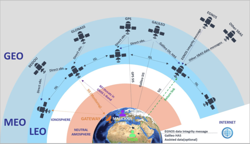
Europe’s Galileo constellation is already the world’s most accurate satellite navigation system, providing metre-level precision to users worldwide. The general expectation is that satnav is going to keep on getting better, in line with increasing user needs and accuracy requirements. But in fact, traditional Global Navigation Satellite Systems (GNSS) in medium Earth orbit are approaching their limits of technical performance.
Industry invited to bid for low-Earth orbit satnav demo
21.6.2023 14:35 ESA Navigation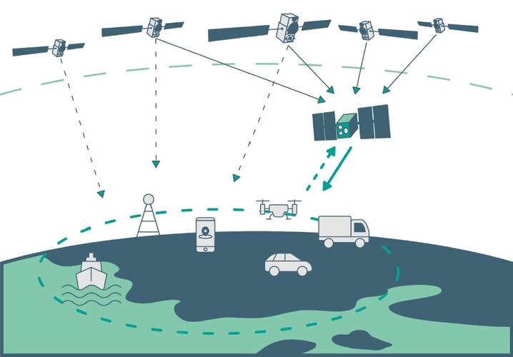
Europe’s Galileo constellation is already the world’s most accurate satellite navigation system, providing metre-level precision to users worldwide. The general expectation is that satnav is going to keep on getting better, in line with increasing user needs and accuracy requirements. But in fact, traditional Global Navigation Satellite Systems (GNSS) in medium Earth orbit are approaching their limits of technical performance.
Paris Air Show live - From Earth science to climate action
21.6.2023 14:15 ESA Observing the EarthParis Air Show live: From Earth science to climate action
22 June at 12:00 CEST: Earth's water and carbon cycles from space
výběrové řízení na KP Jihlava
21.6.2023 12:21 ČÚZK - předpisy a opatření Katastrální úřad pro Vysočinu - Katastrální pracoviště Jihlava zveřejnil novou aktualitu: Oznámení o vyhlášení výběrového řízení na služební místo vrchní referent/rada - oddělení dokumentace KN Katastrálního pracoviště Jihlava na Katastrálním úřadu pro Vysočinu.vrchní referent-rada - dokumentace KN KP Jihlava
21.6.2023 11:57 ČÚZK /Urady/Katastralni-urady/Katastralni-urady/Katastralni-urad-pro-Vysocinu/Uredni-deska/Oznameni-a-jina-uredni-sdeleni/Volna-mista/DMS/vrchni-referent-rada-dokumentace-KN-KP-Jihlavavrchní referent-rada - dokumentace KN KP Jihlava
21.6.2023 11:57 ČÚZK - volná místa Katastrální úřad pro Vysočinu Katastrální pracoviště Jihlava vypisuje výběrové řízení na místo vrchní referent-rada - dokumentace KN KP Jihlavavrchní referent-rada - dokumentace KN KP Jihlava
21.6.2023 11:57 ČÚZK - předpisy a opatření Katastrální úřad pro Vysočinu Katastrální pracoviště Jihlavavypisuje výběrové řízení na místo
vrchní referent-rada - dokumentace KN KP Jihlava
20230621_Odborný / vrchní referent oddělení aktualizace GI KN
21.6.2023 10:56 ČÚZK - předpisy a opatření Katastrální úřad pro Středočeský kraj - Katastrální pracoviště Praha-západ Vyhlášení výběrového řízení: Odborný / vrchní referent oddělení aktualizace GI KN V části "Úřední deska", v sekci "Oznámení a jiná úřední sdělení" bylo vystaveno "Oznámení o vyhlášení výběrového řízení na obsazení služebního místa Odborný / vrchní referent oddělení aktualizace GI KN"20230621_Odborný / vrchní referent oddělení aktualizace GI KN
21.6.2023 10:56 ČÚZK /Urady/Katastralni-urady/Katastralni-urady/Katastralni-urad-pro-Stredocesky-kraj/Katastralni-pracoviste/KP-Praha-zapad/O-uradu/Aktuality/20210922_Odborny-referent-oddeleni-aktualizac-(2)Nedostupnost WSDP na zkoušku 22.6.2023
21.6.2023 10:54 ČÚZK /Aplikace-DP-do-KN/Aplikace-DP-do-KN/Archiv-DP/388933Nedostupnost WSDP na zkoušku 22.6.2023
21.6.2023 10:54 Dálkový přístup k údajům KN ČR Vážení uživatelé,oznamujeme, že dne 22.6.2023 budou v čase od 12 do cca 16:30 nedostupné webové služby dálkového přístupu na zkoušku.
Za komplikace tímto způsobené se omlouváme a děkujeme za pochopení.
Nedostupnost WSDP na zkoušku 22.6.2023
21.6.2023 10:54 ČÚZK - předpisy a opatření Vážení uživatelé,oznamujeme, že dne 22.6.2023 budou v čase od 12 do cca 16:30 nedostupné webové služby dálkového přístupu na zkoušku.
Za komplikace tímto způsobené se omlouváme a děkujeme za pochopení.
20230621_Odborný / vrchní referent oddělení dokumentace KN
21.6.2023 10:00 ČÚZK - předpisy a opatření Katastrální úřad pro Středočeský kraj - Katastrální pracoviště Praha-západ Vyhlášení výběrového řízení: Odborný / vrchní referent oddělení dokumentace KN V části "Úřední deska", v sekci "Oznámení a jiná úřední sdělení" bylo vystaveno "Oznámení o vyhlášení výběrového řízení na obsazení služebního místa Odborný / vrchní referent oddělení dokumentace KN"20230621_Odborný / vrchní referent oddělení dokumentace KN
21.6.2023 10:00 ČÚZK /Urady/Katastralni-urady/Katastralni-urady/Katastralni-urad-pro-Stredocesky-kraj/Katastralni-pracoviste/KP-Praha-zapad/O-uradu/Aktuality/20210922_Odborny-referent-oddeleni-aktualizac-(1)20230621_Odborný referent oddělení aktualizace KN
21.6.2023 9:06 ČÚZK /Urady/Katastralni-urady/Katastralni-urady/Katastralni-urad-pro-Stredocesky-kraj/Katastralni-pracoviste/KP-Benesov/O-uradu/Aktuality/20210922_Odborny-referent-oddeleni-aktualizace-(5)20230621_Odborný referent oddělení aktualizace KN
21.6.2023 9:06 ČÚZK - předpisy a opatření Katastrální úřad pro Středočeský kraj - Katastrální pracoviště Benešov Vyhlášení výběrového řízení: Odborný referent oddělení aktualizace KN V části "Úřední deska", v sekci "Oznámení a jiná úřední sdělení" bylo vystaveno "Oznámení o vyhlášení výběrového řízení na obsazení služebního místa Odborný referent oddělení aktualizace KN"Přerušení provozu DP a WSDP ve čtvrtek 22.6.2023 od 16:30 do cca 18:00.
21.6.2023 6:17 Dálkový přístup k údajům KN ČR Vážení uživatelé,oznamujeme, že ve čtvrtek 22.6.2023 od 16:30 bude z provozních důvodů zcela přerušen provoz Dálkového přístupu i Webových služeb dálkového přístupu. Obnovení provozu předpokládáme v cca 18 hodin. U této verze nedochází ke změnám webových služeb.
Za komplikace tímto způsobené se omlouváme a děkujeme za pochopení.
Přerušení provozu DP a WSDP ve čtvrtek 22.6.2023 od 16:30 do cca 18:00.
21.6.2023 6:17 ČÚZK /Aplikace-DP-do-KN/Aplikace-DP-do-KN/Archiv-DP/388877Přerušení provozu DP a WSDP ve čtvrtek 22.6.2023 od 16:30 do cca 18:00.
21.6.2023 6:17 ČÚZK - předpisy a opatření Vážení uživatelé,oznamujeme, že ve čtvrtek 22.6.2023 od 16:30 bude z provozních důvodů zcela přerušen provoz Dálkového přístupu i Webových služeb dálkového přístupu. Obnovení provozu předpokládáme v cca 18 hodin. U této verze nedochází ke změnám webových služeb.
Za komplikace tímto způsobené se omlouváme a děkujeme za pochopení.
APGEO - Pozvánka na seminář v Pardubicích
21.6.2023 2:00 Asociace podnikatelů v geomatice Seminář k novele zeměměřického zákona, vzniku České komory zeměměřičů a novele katastrální vyhlášky.UK suffers marine heatwave
20.6.2023 15:44 ESA Observing the Earth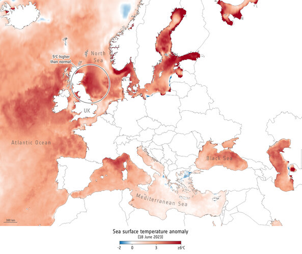 Image:
Some of the most severe marine heat increases on Earth are occurring in the seas surrounding the UK and Ireland. Satellite measurements show that water temperatures in certain areas are above average for this time of year.
Image:
Some of the most severe marine heat increases on Earth are occurring in the seas surrounding the UK and Ireland. Satellite measurements show that water temperatures in certain areas are above average for this time of year.
Oznámení o vyhlášení VŘ na služební místo rada-odborný rada
20.6.2023 14:49 ČÚZK /Urady/Zememericke-a-katastralni-inspektoraty/Zememericke-a-katastralni-inspektoraty/Zememericky-a-katastralni-inspektorat-v-Praze/O-uradu/Aktuality/Oznameni-o-vyhlaseni-VR-na-sluzebni-misto-rada-(2)Oznámení o vyhlášení VŘ na služební místo rada-odborný rada
20.6.2023 14:49 ČÚZK - předpisy a opatření Zeměměřický a katastrální inspektorát v Praze zveřejnil novou aktualitu: Zeměměřický a katastrální inspektorát v Praze vyhlašuje výběrové řízení na služební místo Rada/Odborný rada inspektor (obor služby 55)Rada/odborný rada- inspektor ZKI v Praze (obor služby 55.)
20.6.2023 14:48 ČÚZK /Urady/Zememericke-a-katastralni-inspektoraty/Zememericke-a-katastralni-inspektoraty/Zememericky-a-katastralni-inspektorat-v-Praze/Uredni-deska/Oznameni-a-jina-uredni-sdeleni/Volna-mista/DMS/Rada-odborny-rada-inspektor-ZKI-v-Praze-(obor-(2)Rada/odborný rada- inspektor ZKI v Praze (obor služby 55.)
20.6.2023 14:48 ČÚZK - volná místa Zeměměřický a katastrální inspektorát v Praze vypisuje výběrové řízení na místo Rada/odborný rada- inspektor ZKI v Praze (obor služby 55.)Rada/odborný rada- inspektor ZKI v Praze (obor služby 55.)
20.6.2023 14:48 ČÚZK - předpisy a opatření Zeměměřický a katastrální inspektorát v Prazevypisuje výběrové řízení na místo
Rada/odborný rada- inspektor ZKI v Praze (obor služby 55.)
Úspora spotreby tepla ÚGKK SR po zateplení budovy svojho sídla znížením jej energetickej náročnosti
20.6.2023 13:06
ÚGKK SR
ÚGKK SR zrealizoval obnovu budovy svojho sídla zateplením v priebehu rokov 2021 -2022 tak, aby budova spĺňala minimálne požiadavky na energetickú hospodárnosť budovy podľa zákona č. 555/2005 Z.z. o energetickej hospodárnosti budov, čo v konečnom dôsledku znamenalo nielen úsporu nákladov na energie a zníženie nákladov na prevádzku budovy, ale aj zlepšenie pracovného prostredia zamestnancov. Okrem zlepšenia energetickej hospodárnosti budovy sa obnovou budovy odstránili aj stavebné poruchy budovy a dosiahlo sa aj celkové zlepšenie vzhľadu budovy.
VŘ na prodej nepotřebného majetku
20.6.2023 7:16 ČÚZK /Urady/Katastralni-urady/Katastralni-urady/Katastralni-urad-pro-Liberecky-kraj/Nabidky-majetku/VR-na-prodej-nepotrebneho-majetku-(2)VŘ na prodej nepotřebného majetku
20.6.2023 7:16 ČÚZK - předpisy a opatřeníKatastrální úřad pro Liberecký kraj nabízí nepotřebný majetek k odkupu.
VŘ na prodej nepotřebného majetku
Otevírací doba v červenci a srpnu 2023 [Knihovna geografie, byTopic]
20.6.2023 0:00 Katedra aplikované geoinformatiky a kartografie Přf UK Během prázdnin bude mít knihovna otevřeno každý den pouze od 9 do 11 hodin. Zkrácená otevírací doba souvisí s revizemi, které je knihovna povinna provádět podle knihovního zákona. Děkujeme za pochopení a přejeme příjemné léto!Starostové diskutovali o vodě i suchu. Cílem je uchování vody pro příští generace
19.6.2023 17:03 TopGis Dotace na opatření související se změnou klimatu, hospodaření s omezenými vodními zdroji, ústavní ochrana vody či protipovodňová opatření. To byla některá z témat odborného diskuzního setkání, kterými se v Brně zabývali zástupci Ministerstva životního prostředí ČR, Ministerstva zemědělství ČR, odborných firem, krajů a představitelé měst a obcí. Setkání u kulatého stolu pořádala již tradičně společnost Magnus Regio.Starostové diskutovali o vodě i suchu. Cílem je uchování vody pro příští generace
19.6.2023 15:03 TopGisDotace na opatření související se změnou klimatu, hospodaření s omezenými vodními zdroji, ústavní ochrana vody či protipovodňová opatření. To byla některá z témat odborného diskuzního setkání, kterými se v Brně zabývali zástupci Ministerstva životního prostředí ČR, Ministerstva zemědělství ČR, odborných firem, krajů a představitelé měst a obcí. Setkání u kulatého stolu pořádala již tradičně společnost Magnus ...
Článek Starostové diskutovali o vodě i suchu. Cílem je uchování vody pro příští generace se nejdříve objevil na TopGis, s.r.o..
Starostové diskutovali o vodě i suchu. Cílem je uchování vody pro příští generace
19.6.2023 15:03 TopGisDotace na opatření související se změnou klimatu, hospodaření s omezenými vodními zdroji, ústavní ochrana vody či protipovodňová opatření. To byla některá z témat odborného diskuzního setkání, kterými se v Brně zabývali zástupci Ministerstva životního prostředí ČR, Ministerstva zemědělství ČR, odborných firem, krajů a představitelé měst a obcí. Setkání u kulatého stolu pořádala již tradičně společnost Magnus ...
Článek Starostové diskutovali o vodě i suchu. Cílem je uchování vody pro příští generace se nejdříve objevil na TopGis, s.r.o..
New Space companies join Copernicus
19.6.2023 15:00 ESA Observing the Earth
With commercial companies playing an increasingly important role in creating a dynamic and innovative space industry, nine New Space satellite data suppliers have joined the Copernicus programme as ‘Contributing Missions’. Today, at the Le Bourget Paris Air Show, ESA and the European Commission further embraced the era of New Space by welcoming these nine companies into the fold and celebrating the contribution they will make in monitoring our changing world.
Oznámení o vyhlášení VŘ na služební místo rada-odborný rada
19.6.2023 14:28 ČÚZK - předpisy a opatření Zeměměřický a katastrální inspektorát v Praze zveřejnil novou aktualitu: Zeměměřický a katastrální inspektorát v Praze vyhlašuje výběrové řízení na služební místo Rada/Odborný rada inspektor (obor služby 55)Oznámení o vyhlášení VŘ na služební místo rada-odborný rada
19.6.2023 14:28 ČÚZK /Urady/Zememericke-a-katastralni-inspektoraty/Zememericke-a-katastralni-inspektoraty/Zememericky-a-katastralni-inspektorat-v-Praze/O-uradu/Aktuality/Oznameni-o-vyhlaseni-VR-na-sluzebni-misto-rada-(1)Rada/odborný rada- inspektor ZKI v Praze (obor služby 55.)
19.6.2023 14:27 ČÚZK - volná místa Zeměměřický a katastrální inspektorát v Praze vypisuje výběrové řízení na místo Rada/odborný rada- inspektor ZKI v Praze (obor služby 55.)Rada/odborný rada- inspektor ZKI v Praze (obor služby 55.)
19.6.2023 14:27 ČÚZK - předpisy a opatření Zeměměřický a katastrální inspektorát v Prazevypisuje výběrové řízení na místo
Rada/odborný rada- inspektor ZKI v Praze (obor služby 55.)
Rada/odborný rada- inspektor ZKI v Praze (obor služby 55.)
19.6.2023 14:27 ČÚZK /Urady/Zememericke-a-katastralni-inspektoraty/Zememericke-a-katastralni-inspektoraty/Zememericky-a-katastralni-inspektorat-v-Praze/Uredni-deska/Oznameni-a-jina-uredni-sdeleni/Volna-mista/DMS/Rada-odborny-rada-inspektor-ZKI-v-Praze-(obor-(1)20230619-GaKO
19.6.2023 13:56 ČÚZK - aktuality v resortu Aktuální číslo Geodetického a kartografického obzoru (6/2023) je k dispozici ke stažení.20230619-GaKO
19.6.2023 13:56 ČÚZK - předpisy a opatření Český úřad zeměměřický a katastrální zveřejnil novou aktualitu: Aktuální číslo Geodetického a kartografického obzoru (6/2023) je k dispozici ke stažení.20230619-GaKO
19.6.2023 13:56 ČÚZK - aktuality v resortu Aktuální číslo Geodetického a kartografického obzoru (6/2023) je k dispozici ke stažení.20230619-GaKO
19.6.2023 13:56 ČÚZK - předpisy a opatření Český úřad zeměměřický a katastrální zveřejnil novou aktualitu: Aktuální číslo Geodetického a kartografického obzoru (6/2023) je k dispozici ke stažení.20230718-GaKO
19.6.2023 13:56 ČÚZK - aktuality v resortu Aktuální číslo Geodetického a kartografického obzoru (7/2023) je k dispozici ke stažení.20230718-GaKO
19.6.2023 13:56 ČÚZK - předpisy a opatření Český úřad zeměměřický a katastrální zveřejnil novou aktualitu: Aktuální číslo Geodetického a kartografického obzoru (7/2023) je k dispozici ke stažení.VR do 9.7.2023
19.6.2023 12:59 ČÚZK /Urady/Katastralni-urady/Katastralni-urady/Katastralni-urad-pro-hlavni-mesto-Prahu/O-uradu/Aktuality/VR-do-9-7-2023VR do 9.7.2023
19.6.2023 12:59 ČÚZK - předpisy a opatření Katastrální úřad pro hlavní město Prahu zveřejnil novou aktualitu: Ředitelka úřadu vyhlašuje výběrové řízení na služební místo:Odborný rada - právnik
Odborný rada - právnik
19.6.2023 12:53 ČÚZK - volná místa Katastrální úřad pro hlavní město Prahu vypisuje výběrové řízení na místo Odborný rada - právnikAn update on IFC developments
19.6.2023 12:44 czBIMIFC 4.3.x In an earlier blog I reported that IFC 4.3 – the latest openBIM standard from buildingSMART International – had formally entered the next...
Článek An update on IFC developments se nejdříve objevil na czBIM.
An update on IFC developments
19.6.2023 12:44 czBIMIFC 4.3.x In an earlier blog I reported that IFC 4.3 – the latest openBIM standard from buildingSMART International – had formally entered the next...
Článek An update on IFC developments se nejdříve objevil na czBIM.
An update on IFC developments
19.6.2023 12:44 czBIMIFC 4.3.x In an earlier blog I reported that IFC 4.3 – the latest openBIM standard from buildingSMART International – had formally entered the next...
Článek An update on IFC developments se nejdříve objevil na czBIM.
Odborný rada - právnik
19.6.2023 11:22 ČÚZK /Urady/Katastralni-urady/Katastralni-urady/Katastralni-urad-pro-hlavni-mesto-Prahu/Uredni-deska/Oznameni-a-jina-uredni-sdeleni/Volna-mista/Odborny-rada-pravnikOdborný rada - právnik
19.6.2023 11:22 ČÚZK - předpisy a opatření Katastrální úřad pro hlavní město Prahuvypisuje výběrové řízení na místo
Odborný rada - právnik
GOVSATCOM implementation continues to advance
19.6.2023 10:37 European GNSS Agency
The implementation of GOVSATCOM, Europe’s Governmental Satellite Communications programme, continues to move forward. Most recently, on 30 May 2023, the European Commission adopted three Implementing Acts. These Acts provide the legal foundation for the services that GOVSATCOM, along with IRIS2 (Infrastructure for Resilience, Interconnectivity and Security by Satellite), will offer.
GOVSATCOM, the fourth pillar of the EU Space Programme, will provide secure and cost-efficient communication capabilities to security and safety critical missions and operations managed by the EU and its Member States, including national security actors and EU agencies and institutions. EUSPA has been entrusted with the procurement of GOVSATCOM’s secure operational ground segment (GOVSATCOM Hubs), its operations and the coordination of the user-related aspects of the programme, all in close collaboration with Member States and other involved entities.
Check this: EUSPA is hiring a GOVSATCOM Hub Operations Manager
The IRIS2 satellite constellation will provide secure communication services to the EU and its Member States, as well as broadband connectivity for European citizens, private companies and governmental authorities. The EUSPA Security Accreditation Board (SAB), where Members States take accreditation decisions, will become the IRIS2 security accreditation authority, providing security assurance to users with regards to IRIS2 services and infrastructure.
EUSPA contributes to Implementing Acts
Through the Implementing Acts, the Commission establishes which satellite communications service categories are to be pooled and shared and defines the services IRIS2 will provide. The Acts also outline the GOVSATCOM Hubs’ functionalities and operational aspects, presentation of the pooled capacities to the users through the service portfolio, service selection process and use of GOVSATCOM services by the users.
EUSPA supported the Commission in preparing the Acts, contributing to their drafting and helping assess and integrate comments from the Member States. The Agency also lent their technical expertise and provided input from governmental users, the latter of which came from the EU-funded ENTRUSTED project. The project was established to provide a concrete set of governmental user requirements for GOVSATCOM services.
The full text of the Implementing Acts, as published in the Official Journal of the EU, can be found via the following links:
- Commission Implementing Decision (EU) 2023/1054 of 30 May 2023 laying down rules for the application of Regulation (EU) 2021/696 of the European Parliament and of the Council as regards the service portfolio for the Governmental Satellite Communications services offered by the system established under the Union Space Programme OJ L 141, 31.5.2023, p. 49–56.
- Commission Implementing Decision (EU) 2023/1055 of 30 May 2023 setting out the rules on the sharing and prioritisation of satellite communication capacities, services, and user equipment to fulfil the function referred to in Article 66(2) of Regulation (EU) 2021/696 of the European Parliament and of the Council OJ L 141, 31.5.2023, p. 57–66.
- Commission Implementing Decision (EU) 2023/1053 of 30 May 2023 laying down rules for the application of Regulation (EU) 2023/588 of the European Parliament and of the Council as regards operational requirements for governmental services provided under Union Secure Connectivity Programme and its service portfolio OJ L 141, 31.5.2023, p. 44–48.
Media note: This feature can be republished without charge provided the European Union Agency for the Space Programme (EUSPA) is acknowledged as the source at the top or the bottom of the story. You must request permission before you use any of the photographs on the site. If you republish, we would be grateful if you could link back to the EUSPA website (http://www.euspa.europa.eu).
Upozornění na STOP-STAV
19.6.2023 8:34 ČÚZK /Urady/Katastralni-urady/Katastralni-urady/Katastralni-urad-pro-Liberecky-kraj/Katastralni-pracoviste/KP-Semily/O-uradu/Aktuality/Upozorneni-na-STOP-STAVUpozornění na STOP-STAV
19.6.2023 8:34 ČÚZK - předpisy a opatření Katastrální úřad pro Liberecký kraj - Katastrální pracoviště Semily zveřejnil novou aktualitu: Na části katastrálního území Víchová n. Jiz. byl vyhlášen STOP-STAV pro zápisy do katastru (vklady a záznamy), rezervace ZPMZ a nových parcelních čísel do doby zplatnění obnoveného katastrálního operátu přepracováním.Listiny budou pouze přijaty a zaplombovány.
Geodetickou veřejnost tímto žádáme, aby danému STOP-STAVU přizpůsobili plánované, nebo rozpracované zakázky v tomto katastrálním území.
Nové číslo GaKO
19.6.2023 8:01
ÚGKK SR
Nové číslo časopisu Geodetického a Kartografického Obzoru 06/2023
APGEO - Oznámení ČÚZK pro ÚOZI (AZI)
19.6.2023 2:00 Asociace podnikatelů v geomatice ČÚZK vydal oznámení pro ÚOZI týkající se nově vznikající České komory zeměměřičů.TurboCAD MAC Designer 12 CZ v akční ceně
16.6.2023 18:50 ŠPINAR - softwareVážení zákazníci, dovolujeme si Vám nabídnout program TurboCAD MAC Designer pro 2D kreslení v češtině. v akční ceně do 25.6.2023.
The post TurboCAD MAC Designer 12 CZ v akční ceně appeared first on ŠPINAR – software.
TurboCAD MAC Designer 12 CZ v akční ceně
16.6.2023 18:50 ŠPINAR - softwareVážení zákazníci, dovolujeme si Vám nabídnout program TurboCAD MAC Designer pro 2D kreslení v češtině. v akční ceně do 25.6.2023.
The post TurboCAD MAC Designer 12 CZ v akční ceně appeared first on ŠPINAR – software.
Fundamental Elements Industry Days Workshop: Developing cutting-edge devices for connectivity
16.6.2023 16:00 European GNSS Agency
EUSPA plays a crucial role in supporting the EU Space industry throughout the innovation cycle, providing funding and market intelligence. One of the notable tools that has significantly contributed to the adoption of Galileo is the Fundamental Elements programme. This R&D funding mechanism is specifically designed to support the development of innovative chipset, antenna, and receiver technologies.
By leveraging the Fundamental Elements programme, EUSPA accelerates the integration of Galileo into market-ready devices and solutions.
The objectives can be summarized as follows:
- Facilitate the adoption of EGNSS (European Global Navigation Satellite Systems), leveraging innovative services and differentiators.
- Enhance the competitiveness of the EU industry in the global market.
- Address user needs in critical market segments.
- Maximize the benefits of Galileo for European citizens.
Projects funded through the Fundamental Elements programme play a pivotal role in EUSPA's mission to drive the development and market uptake of Galileo-enabled receivers. These initiatives contribute to the growth and success of the EU Space industry, fostering innovation and ensuring the wide availability of reliable and advanced positioning, navigation, and timing services.
The new call currently open is looking to support the development of a hybrid terminal for connectivity for cutting-edge devices.
Connectivity: Enabling next generation NAV/COM Hybrid Terminal
As the number of connected devices is growing exponentially, the focus has shifted to solution owners locating all assets simultaneously with minimal power drain. It's no longer about individual assets locating themselves, but about efficient, centralized asset tracking solutions. This approach optimizes power consumption while providing real-time visibility and operational efficiency.
In this context, integrating Terrestrial Networks (TN) and Non-Terrestrial Networks (NTN) have the potential of connecting the unconnected and enhancing the user experience for the already-connected devices, with technological and societal implications of the greatest long-term significance.
Objectives:
Development of a unified hybrid user terminal, that shall support (and process):
- From communication perspective: TN and NTN communication signals
- From Navigation perspective: signals from GNSS and LEO for PNT
And optionally can support (and process):
- From communication to navigation perspective (COM2NAV): communication signals to provide localization services according to several wireless communication methods
- From navigation to communication perspective (NAV2COM): (considering GNSS and all other PNT functions) positioning, ranging and time synchronization to improve data acquisition task by channel estimation, beam alignment, medium access control, routing, and network optimization.
Foreseen result:
Unified hybrid user terminal capable to support TN and NTN communication together with GNSS, and Galileo in particular, and LEO satellite signals in order to support joint Data & PNT services, reaching TRL 7.
The maximum budget is set to 3 M€ and the indicative number of projects to be awarded is four.
Deadline for submission: 15 September 2023
More details about this call will be made available during EUSPA’s upcoming Fundamental Elements online Workshop via Webex, to be held on 30 June from 11.00 to 12.30 CEST. The workshop will include in-depth information on the funding programme and the application process. More information is available at this link.
The Fundamental Elements Industry Days Workshop: Developing cutting-edge devices for connectivity, will include in-depth information on the funding programme and the application process as well as insights about the calls.
Join us here
Media note: This feature can be republished without charge provided the European Union Agency for the Space Programme (EUSPA) is acknowledged as the source at the top or the bottom of the story. You must request permission before you use any of the photographs on the site. If you republish, we would be grateful if you could link back to the EUSPA website (http://www.euspa.europa.eu).
What’s in a name?
16.6.2023 14:19 buildingSMART.orgWhat’s in a name? Well, when it comes to the buildingSMART Domains, quite a lot. Domains represent specific areas of the built asset industry, and they have one major thing…
The post What’s in a name? appeared first on buildingSMART International.
Katastrální vyhláška se změnila. Záznam semináře a komentovaná vyhláška
16.6.2023 13:37 ZeměměřičČÚZK na svém webu 6. prosince oznámil, že dne 23. 11. byla ve Sbírce zákonů uveřejněna vyhláška č. 346/2022 Sb., kterou se mění vyhláška č. 357/2013 Sb., o katastru nemovitostí (katastrální vyhláška), ve znění pozdějších předpisů. Účinnost vyhlášky nastává dnem 1. 1. 2023. Přednášejícím na webináři byl Ing. Jan Pěčonka, HD GEO s.r.o., člen Asociace podnikatelů v geomatice (APG). APG měla v rámci pracovní skupiny […]
The post Katastrální vyhláška se změnila. Záznam semináře a komentovaná vyhláška appeared first on Zeměměřič.
20230616-ÚOZI
16.6.2023 12:58 ČÚZK - aktuality v resortu Upozorňujeme úředně oprávněné zeměměřické inženýry, že do 15. 7. 2023 mohou podávat návrhy na složení přípravného výboru České komory zeměměřičů. Více informací ZDE.20230616-ÚOZI
16.6.2023 12:58 ČÚZK - předpisy a opatření Český úřad zeměměřický a katastrální zveřejnil novou aktualitu: Upozorňujeme úředně oprávněné zeměměřické inženýry, že do 15. 7. 2023 mohou podávat návrhy na složení přípravného výboru České komory zeměměřičů. Více informací ZDE.20231606-ÚOZI
16.6.2023 12:58 ČÚZK - předpisy a opatření Český úřad zeměměřický a katastrální zveřejnil novou aktualitu: Upozorňujeme úředně oprávněné zeměměřické inženýry, že do 15. 7. 2023 mohou podávat návrhy na složení přípravného výboru České komory zeměměřičů. Více informací ZDE.20231606-ÚOZI
16.6.2023 12:58 ČÚZK - aktuality v resortu Upozorňujeme úředně oprávněné zeměměřické inženýry, že do 15. 7. 2023 mohou podávat návrhy na složení přípravného výboru České komory zeměměřičů. Více informací ZDE.Earth from Space: Eastern Mediterranean
16.6.2023 10:00 ESA Observing the Earth Image:
Copernicus Sentinel-3’s wide view captures the eastern edge of the Mediterranean and surrounding countries.
Image:
Copernicus Sentinel-3’s wide view captures the eastern edge of the Mediterranean and surrounding countries.
Budoucnost Autodesk EAGLE: Přechod k Fusion 360 Electronics
16.6.2023 9:00 Adeon
Společnost Autodesk, oznámila změny, které se týkají produktu Autodesk EAGLE a Fusion 360. Chtěli bychom se s vámi podělit o […]
The post Budoucnost Autodesk EAGLE: Přechod k Fusion 360 Electronics appeared first on Adeon CZ.
Budoucnost Autodesk EAGLE: Přechod k Fusion 360 Electronics
16.6.2023 9:00 AdeonS nadcházející zářijovou aktualizací produktu Fusion 360 ohlásil Autodesk změnu v prostředí simulací. Všechny simulace budou od 6. Září přesunuty do cloudu.
The post Budoucnost Autodesk EAGLE: Přechod k Fusion 360 Electronics appeared first on Adeon CZ.
Budoucnost Autodesk EAGLE: Přechod k Fusion 360 Electronics
16.6.2023 9:00 AdeonSpolečnost Autodesk, oznámila změny, které se týkají produktu Autodesk EAGLE a Fusion 360. Chtěli bychom se s vámi podělit o […]
The post Budoucnost Autodesk EAGLE: Přechod k Fusion 360 Electronics appeared first on Adeon CZ.
Carbon monoxide from fires in Canada
15.6.2023 14:37 ESA Observing the Earth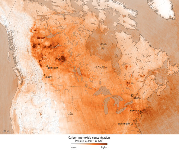 Image:
As climate change increases the risk of wildfires across the globe, the spate of fires that hit Canada in May and June suggest that 2023 is on course to be the country’s worst fire season to date. These fires not only pose a serious threat to human life, wildlife, the environment and property, they also affect air quality.
Image:
As climate change increases the risk of wildfires across the globe, the spate of fires that hit Canada in May and June suggest that 2023 is on course to be the country’s worst fire season to date. These fires not only pose a serious threat to human life, wildlife, the environment and property, they also affect air quality.
ISÚI PROD - systémová chyba opravena
15.6.2023 14:20 ČÚZK /ruian/Editacni-agendovy-system-ISUI/Provozni-informace-a-odstavky/Archiv-PROD/ISUI-PROD-systemova-chyba-opravenaRada / odborný rada – vedoucí oddělení právních vztahů k nemovitostem Katastrálního pracoviště Kromě
15.6.2023 11:55 ČÚZK - volná místa Katastrální úřad pro Zlínský kraj Katastrální pracoviště Kroměříž vypisuje výběrové řízení na místo Rada / odborný rada – vedoucí oddělení právních vztahů k nemovitostem Katastrálního pracoviště KroměRada / odborný rada – vedoucí oddělení právních vztahů k nemovitostem Katastrálního pracoviště Kromě
15.6.2023 11:55 ČÚZK /Urady/Katastralni-urady/Katastralni-urady/Katastralni-urad-pro-Zlinsky-kraj/Uredni-deska/Oznameni-a-jina-uredni-sdeleni/Volna-mista/DMS/Rada-odborny-rada-–-vedouci-oddeleni-pravnich-vztaRada / odborný rada – vedoucí oddělení právních vztahů k nemovitostem Katastrálního pracoviště Kromě
15.6.2023 11:55 ČÚZK - předpisy a opatření Katastrální úřad pro Zlínský kraj Katastrální pracoviště Kroměřížvypisuje výběrové řízení na místo
Rada / odborný rada – vedoucí oddělení právních vztahů k nemovitostem Katastrálního pracoviště Kroměříž
Upozornění na podvodné e-maily
15.6.2023 11:40 GEPROVážení zákazníci, v posledních dnech jsme zaznamenali, že dostáváte PODVODNÉ EMAILY, které vás vyzývají k zaplacení faktur na nové bankovní údaje společnosti GEPRO spol. s r.o. Žádný takový e-mail rozesílám nebyl a společnost GEPRO spol. s r.o. není autorem těchto podvodných zpráv. Vždy si prosím zkontrolujte e‑mailovou adresu odesílatele. Příklad podvodného e-mailu:
Článek Upozornění na podvodné e-maily se nejdříve objevil na GEPRO.