


![]()

zprávy
zdroje zpráv:From First Fix to High Accuracy Service, Galileo scores high
9.3.2023 10:36 European GNSS Agency
"From a historical perspective this was one the greatest achievements of the EU," says EUSPA Executive director Rodrigo da Costa. "Determining a position on the ground using only Galileo was essentially the first step towards shielding our autonomy and sovereignty in space." he highlights.
This first position fix of longitude, latitude and altitude using the Galileo constellation took place at the Navigation Laboratory at ESA’s technical heart ESTEC, in Noordwijk, Netherlands on the morning of 12 March, with a level of accuracy between 10 and 15 metres.
Since then, Galileo has been growing, exceeding performance expectations, and enabling a multitude of applications thanks to the broad range of services it offers.
A significant milestone was marked in 2016 with the declaration of Galileo Initial Services to become available at the end of that year providing guaranteed services to users. As of today, the EU’s positioning system offers a set of services to end users with more currently under development.
With 28 satellites currently in orbit the system offers:
Open Service (OS): Open Service (OS) enables free-of-charge, global ranging, positioning and timing, using the Galileo OS Signal-In-Space (SIS).
Search and Rescue Service (SAR): The Galileo Search and Rescue service allows for the location of people in distress within 10 minutes and a radius below 5km. All you need is a Galileo-enabled Personal Location Beacon (PLB).
High Accuracy Service (HAS): On the basis of this brand new service, declared operational on the 24/01/2024, Galileo becomes the first GNSS system providing, globally and free of charge, corrections to the Galileo and GPS signals to enable a positioning accuracy down to decimetre level (when processed by a Precise Point Positioning (PPP) algorithm by the user).
"The main power of Galileo is felt in the downstream sector, especially if we think that over 4 billion Galileo-enabled smartphones have been sold and that millions of users in many sectors rely on it.” concludes EUSPA Executive Director, Rodrigo da Costa.
Read this: Another step for EU’s positioning system: Nikolina joins the Galileo family!
What’s next?
The Galileo is being continuously improved to ensure seamless, safe and secured service delivery 24/7 to users worldwide. EUSPA is currently working on delivering next-generation services based on Galileo’s precise signals, timing capabilities and robust performance.
Likewise, upon a successful public observation phase ongoing since November 2021, the Galileo OSNMA is expected to become operational within the coming year. The OSNMA is a new, breakthrough feature of Europe’s positioning system that meets a clear user need: improve the trustworthiness of GNSS signals. This service provides an authentication mechanism to allow Open Service users to verify that the navigation data they have received comes directly from Galileo and has not been modified.
Media note: This feature can be republished without charge provided the European Union Agency for the Space Programme (EUSPA) is acknowledged as the source at the top or the bottom of the story. You must request permission before you use any of the photographs on the site. If you republish, we would be grateful if you could link back to the EUSPA website (http://www.euspa.europa.eu).
From First Fix to High Accuracy Service, Galileo scores high
9.3.2023 10:36 European GNSS Agency"From a historical perspective this was one the greatest achievements of the EU," says EUSPA Executive director Rodrigo da Costa. "Determining a position on the ground using only Galileo was essentially the first step towards shielding our autonomy and sovereignty in space." he highlights.
This first position fix of longitude, latitude and altitude using the Galileo constellation took place at the Navigation Laboratory at ESA’s technical heart ESTEC, in Noordwijk, Netherlands on the morning of 12 March 2013, with a level of accuracy between 10 and 15 metres.
Since then, Galileo has been growing, exceeding performance expectations, and enabling a multitude of applications thanks to the broad range of services it offers.
A significant milestone was marked in 2016 with the declaration of Galileo Initial Services to become available at the end of that year providing guaranteed services to users. As of today, the EU’s positioning system offers a set of services to end users with more currently under development.
With 28 satellites currently in orbit the system offers:
Open Service (OS): Open Service (OS) enables free-of-charge, global ranging, positioning and timing, using the Galileo OS Signal-In-Space (SIS).
Search and Rescue Service (SAR): The Galileo Search and Rescue service allows for the location of people in distress within 10 minutes and a radius below 5km. All you need is a Galileo-enabled Personal Location Beacon (PLB).
High Accuracy Service (HAS): On the basis of this brand new service, declared operational on the 24/01/2023, Galileo becomes the first GNSS system providing, globally and free of charge, corrections to the Galileo and GPS signals to enable a positioning accuracy down to decimetre level (when processed by a Precise Point Positioning (PPP) algorithm by the user).
"The main power of Galileo is felt in the downstream sector, especially if we think that over 4 billion Galileo-enabled smartphones have been sold and that millions of users in many sectors rely on it.” concludes EUSPA Executive Director, Rodrigo da Costa.
Read this: Another step for EU’s positioning system: Nikolina joins the Galileo family!
What’s next?
The Galileo is being continuously improved to ensure seamless, safe and secured service delivery 24/7 to users worldwide. EUSPA is currently working on delivering next-generation services based on Galileo’s precise signals, timing capabilities and robust performance.
Likewise, upon a successful public observation phase ongoing since November 2021, the Galileo OSNMA is expected to become operational within the coming year. The OSNMA is a new, breakthrough feature of Europe’s positioning system that meets a clear user need: improve the trustworthiness of GNSS signals. This service provides an authentication mechanism to allow Open Service users to verify that the navigation data they have received comes directly from Galileo and has not been modified.
Media note: This feature can be republished without charge provided the European Union Agency for the Space Programme (EUSPA) is acknowledged as the source at the top or the bottom of the story. You must request permission before you use any of the photographs on the site. If you republish, we would be grateful if you could link back to the EUSPA website (http://www.euspa.europa.eu).
poskytování informací KN a PK, poskytování podkladů, nahlížení do KN
9.3.2023 7:12 ČÚZK - volná místa Katastrální úřad pro Olomoucký kraj vypisuje výběrové řízení na místo poskytování informací KN a PK, poskytování podkladů, nahlížení do KNposkytování informací KN a PK, poskytování podkladů, nahlížení do KN
9.3.2023 7:12 ČÚZK - předpisy a opatření Katastrální úřad pro Olomoucký kraj Katastrální pracoviště Šumperkvypisuje výběrové řízení na místo
poskytování informací KN a PK, poskytování podkladů, nahlížení do KN
poskytování informací KN a PK, poskytování podkladů, nahlížení do KN
9.3.2023 7:12 ČÚZK /Urady/Katastralni-urady/Katastralni-urady/Katastralni-urad-pro-Olomoucky-kraj/Volna-mista/DMS/poskytovani-informaci-KN-a-PK,-poskytovani-podkladposkytování informací KN a PK, poskytování podkladů, nahlížení do KN
9.3.2023 7:12 ČÚZK - předpisy a opatření Katastrální úřad pro Olomoucký krajvypisuje výběrové řízení na místo
poskytování informací KN a PK, poskytování podkladů, nahlížení do KN
poskytování informací KN a PK, poskytování podkladů, nahlížení do KN
9.3.2023 7:12 ČÚZK - volná místa Katastrální úřad pro Olomoucký kraj Katastrální pracoviště Šumperk vypisuje výběrové řízení na místo poskytování informací KN a PK, poskytování podkladů, nahlížení do KNRailway Room Charter
8.3.2023 20:00 buildingSMART.orgPlease follow the link to view the document. Go to document
The post Railway Room Charter appeared first on buildingSMART International.
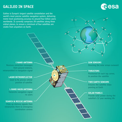 Image:
Galileo in space – infographic
Image:
Galileo in space – infographic
Nová série rovinných laserů CL1
8.3.2023 13:55 3gon S hrdostí oznamujeme, že se nabídka měřicích přístrojů společnosti Nivel System rozšířila o novou řadu rovinných laserů s horizontálním paprskemValné zhromaždenie
8.3.2023 13:43 Komora geodetů a kartografů SRThe post Valné zhromaždenie appeared first on Komora geodetov a kartografov.
Valné zhromaždenie
8.3.2023 13:43 Komora geodetů a kartografů SRThe post Valné zhromaždenie appeared first on Komora geodetov a kartografov.
Navigation Lab exploring Galileo’s future – and beyond
8.3.2023 13:00 ESA Navigation
Would you like to know the future of satellite navigation? Try ESA’s Navigation Laboratory. This is a site where navigation engineers test prototypes of tomorrow's user receivers, using simulated versions of the navigation signals planned for the coming decade, such as set to be transmitted from Galileo’s Second Generation satellites.
Valné zhromaždenie KGK 2023
8.3.2023 12:45 Komora geodetů a kartografů SRThe post Valné zhromaždenie KGK 2023 appeared first on Komora geodetov a kartografov.
Fotogrametrické skenovanie v geodézii
8.3.2023 12:26 Komora geodetů a kartografů SRThe post Fotogrametrické skenovanie v geodézii appeared first on Komora geodetov a kartografov.
Fotogrametrické skenovanie v geodézii
8.3.2023 12:26 Komora geodetů a kartografů SRThe post Fotogrametrické skenovanie v geodézii appeared first on Komora geodetov a kartografov.
Krátka správa č. 14/2023
8.3.2023 12:03 Komora geodetů a kartografů SRThe post Krátka správa č. 14/2023 appeared first on Komora geodetov a kartografov.
Krátka správa č. 13/2023
8.3.2023 11:47 Komora geodetů a kartografů SRThe post Krátka správa č. 13/2023 appeared first on Komora geodetov a kartografov.
Aktualizace harmonogramu IS DMVS
8.3.2023 9:34 ČÚZK - předpisy a opatření V záložce Předpokládané termíny realizace byly aktualizovány milníky projektu DMVS a navázaných DTM krajů a dokument Rámcový harmonogram klíčových kroků při budování IS DMVSPorucha na telefonní ústředně
8.3.2023 9:11 ČÚZK /Urady/Katastralni-urady/Katastralni-urady/Katastralni-urad-pro-Liberecky-kraj/Katastralni-pracoviste/KP-Semily/O-uradu/Aktuality/Porucha-na-telefonni-ustrednePorucha na telefonní ústředně
8.3.2023 9:11 ČÚZK - předpisy a opatření Český úřad zeměměřický a katastrální zveřejnil novou aktualitu: Máme poruchu na telefonní ústředně a nelze se na naše pracoviště dovolat. Za vzniklé problémy seomlouváme.
8.3. 2023
ředitel KP Semily
Ing. Jiří Bekr
Odborný referent v oddělení aktualizace KN na Katastrálním pracovišti Hodonín
8.3.2023 8:52 ČÚZK - předpisy a opatření Katastrální úřad pro Jihomoravský kraj Katastrální pracoviště Hodonínvypisuje výběrové řízení na místo
Odborný referent v oddělení aktualizace KN na Katastrálním pracovišti Hodonín
Odborný referent v oddělení aktualizace KN na Katastrálním pracovišti Hodonín
8.3.2023 8:52 ČÚZK - volná místa Katastrální úřad pro Jihomoravský kraj Katastrální pracoviště Hodonín vypisuje výběrové řízení na místo Odborný referent v oddělení aktualizace KN na Katastrálním pracovišti HodonínOdborný referent v oddělení aktualizace KN na Katastrálním pracovišti Hodonín
8.3.2023 8:52 ČÚZK /Urady/Katastralni-urady/Katastralni-urady/Katastralni-urad-pro-Jihomoravsky-kraj/Uredni-deska/Oznameni-a-jina-uredni-sdeleni/Volna-mista/DMS/Odborny-referent-v-oddeleni-aktualizace-KN-na-Kata20230308_Rada / odborný rada – interní auditor
8.3.2023 8:37 ČÚZK - předpisy a opatření Katastrální úřad pro Středočeský kraj Vyhlášení výběrového řízení: Rada / odborný rada – interní auditor V části "Úřední deska", v sekci "Oznámení a jiná úřední sdělení" bylo vystaveno "Oznámení o vyhlášení výběrového řízení na obsazení služebního místa Rada / odborný rada – interní auditor"20230308_Rada / odborný rada – interní auditor
8.3.2023 8:37 ČÚZK /Urady/Katastralni-urady/Katastralni-urady/Katastralni-urad-pro-Stredocesky-kraj/O-uradu/Aktuality/20210922_Odborny-referent-oddeleni-aktualizac-(12)Konference GIS Esri v ČR 2022 je již na YouTube
8.3.2023 8:18 GISportal.cz
Pokud jste nestihli osobně letošní Konferenci GIS Esri v ČR, tak na YouTube kanále ARCDATA PRAHA naleznete nových 36 videí z této akce.
The post Konference GIS Esri v ČR 2022 je již na YouTube appeared first on GISportal.cz.
Konference GIS Esri v ČR 2022 je již na YouTube
8.3.2023 8:18 GISportal.czPokud jste nestihli osobně letošní Konferenci GIS Esri v ČR, tak na YouTube kanále ARCDATA PRAHA naleznete nových 36 videí z této akce.
The post Konference GIS Esri v ČR 2022 je již na YouTube appeared first on GISportal.cz.
Rozpočet úřadu za rok 2023
8.3.2023 8:09 ČÚZK /Urady/Katastralni-urady/Katastralni-urady/Katastralni-urad-pro-Liberecky-kraj/Rozpocet/Rozpocet-uradu-za-rok-2023Rozpočet úřadu za rok 2023
8.3.2023 8:09 ČÚZK - předpisy a opatření Katastrální úřad pro Liberecký krajvystavuje rozpočet úřadu za rok 2023
2023
20230308_Odborný / vrchní referent oddělení aktualizace PI KN I.
8.3.2023 8:08 ČÚZK - předpisy a opatření Katastrální úřad pro Středočeský kraj - Katastrální pracoviště Praha-východ Vyhlášení výběrového řízení: Odborný / vrchní referent oddělení aktualizace PI KN I. V části "Úřední deska", v sekci "Oznámení a jiná úřední sdělení" bylo vystaveno "Oznámení o vyhlášení výběrového řízení na obsazení služebního místa Odborný / vrchní referent oddělení aktualizace PI KN I."20230308_Odborný / vrchní referent oddělení aktualizace PI KN I.
8.3.2023 8:08 ČÚZK /Urady/Katastralni-urady/Katastralni-urady/Katastralni-urad-pro-Stredocesky-kraj/Katastralni-pracoviste/KP-Praha-vychod/O-uradu/Aktuality/20210922_Odborny-referent-oddeleni-aktualizace-(5)Odborný / vrchní referent oddělení aktualizace PI KN I.
8.3.2023 8:06 ČÚZK /Urady/Katastralni-urady/Katastralni-urady/Katastralni-urad-pro-Stredocesky-kraj/Uredni-deska/Oznameni-a-jina-uredni-sdeleni/Volna-mista/DMS/Odborny-vrchni-referent-oddeleni-aktualizace-PI-KNOdborný / vrchní referent oddělení aktualizace PI KN I.
8.3.2023 8:06 ČÚZK - volná místa Katastrální úřad pro Středočeský kraj Katastrální pracoviště Praha-východ vypisuje výběrové řízení na místo Odborný / vrchní referent oddělení aktualizace PI KN I.Odborný / vrchní referent oddělení aktualizace PI KN I.
8.3.2023 8:06 ČÚZK - předpisy a opatření Katastrální úřad pro Středočeský kraj Katastrální pracoviště Praha-východvypisuje výběrové řízení na místo
Odborný / vrchní referent oddělení aktualizace PI KN I.
20230308 - volné místo – Vrchní referent/rada v OPICT technického odboru na Katastr. úřadu pro ÚK
8.3.2023 6:32 ČÚZK /Urady/Katastralni-urady/Katastralni-urady/Katastralni-urad-pro-Ustecky-kraj/O-uradu/Aktuality/20230308-volne-misto-–-Vrchni-referent-rada-v-OPIC20230308 - volné místo – Vrchní referent/rada v OPICT technického odboru na Katastr. úřadu pro ÚK
8.3.2023 6:32 ČÚZK - předpisy a opatření Katastrální úřad pro Ústecký kraj zveřejnil novou aktualitu: Nabídka volného místa - Vrchní referent / rada v oddělení podpory ICT technického odboru na Katastrálním úřadu pro Ústecký krajVrchní referent / rada v oddělení podpory ICT technického odboru na Katastrálním úřadu pro Ústecký k
8.3.2023 6:28 ČÚZK - volná místa Katastrální úřad pro Ústecký kraj technický odbor vypisuje výběrové řízení na místo Vrchní referent / rada v oddělení podpory ICT technického odboru na Katastrálním úřadu pro Ústecký kVrchní referent / rada v oddělení podpory ICT technického odboru na Katastrálním úřadu pro Ústecký k
8.3.2023 6:28 ČÚZK - předpisy a opatření Katastrální úřad pro Ústecký kraj technický odborvypisuje výběrové řízení na místo
Vrchní referent / rada v oddělení podpory ICT technického odboru na Katastrálním úřadu pro Ústecký kraj
Vrchní referent / rada v oddělení podpory ICT technického odboru na Katastrálním úřadu pro Ústecký k
8.3.2023 6:28 ČÚZK /Urady/Katastralni-urady/Katastralni-urady/Katastralni-urad-pro-Ustecky-kraj/Uredni-deska/Oznameni-a-jina-uredni-sdeleni/Volna-mista/DMS/Vrchni-referent-rada-v-oddeleni-podpory-ICT-techniAPGEO - Senát schválil Českou komoru zeměměřičů
8.3.2023 1:00 Asociace podnikatelů v geomatice Horní komora parlamentu schválila na svém středečním zasedání vznik České komory zeměměřičů.Successful demonstration of GOVSATCOM use cases
7.3.2023 15:20 European GNSS Agency in Rome.")
In a shifting geopolitical landscape, secure and uninterrupted communications are vital for the sovereignty and autonomy of the European Union. In cases of crises, natural disasters, or unavailability of ground-based operators, governmental actors need access to rapidly deployable and robust satellite communications capabilities.
The EU GOVSATCOM, aims to provide initial services within 2024, will ensure the long-term availability of reliable, secure, and cost-effective governmental satellite communications services for EU and national public authorities managing security critical missions and infrastructures. During the first implementation phase running, EU GOVSATCOM will use the capacities and services provided by existing national satcom systems and accredited private operators. Access to these existing infrastructures will be provided through one or several operational Hubs interconnecting the users and the operations centres of the different satcom suppliers in a smart and secure manner.
In 2020, the H2020-funded ENTRUSTED project was set up to provide a concrete set of governmental user requirements for the upcoming GOVSATCOM services under the leadership of the EU Agency for the Space Programme (EUSPA). With over 25 participating entities including EU Member States and agencies, the consortium's partners joined forces to also assess the currently available state-of-the-art for SatCom technologies, analyse the future trends and identify key technological gaps and opportunities, including aspects such as standardisation and interoperability.
On March 2nd, 2023, four operational GOVSATCOM use cases were demonstrated by the ENTRUSTED consortium members during a live event at the headquarters of the Italian Space Agency (ASI) in Rome, Italy. The event was met with great enthusiasm and gathered representatives of the Network of Users, current and prospective users of GOVSATCOM services, national experts and decision-makers. It was also a unique opportunity to discuss different aspects of secure satellite connectivity, share experience and draw attention to more specific user expectations. During the demo phase, attendees experienced real-time satellite connections in an operational environment.
A first scenario was showcased live, demonstrating the access to secure SATCOM services for both a land vehicle via on-the-move technology and a fixed ground terminal in an emergency theatre, pooling together space connectivity from the Italian Athena-Fidus and the Luxembourg national system.
Use Case No. 2 by the Luxembourg Space Agency involved simulations of a natural disaster and an armed conflict and highlighted the secured capabilities of GOVSAT-1 co-owned by SES and the Luxembourg government.
Use case No. 3 by the Hellenic ministries of Digital Governance and Defence showcased a multilateral, highly secured video conference between three Greek EU Delegations and the Ministry of Foreign Affairs. The connection was facilitated by the country’s national operator Hellas SAT, which provides governmental actors with high-throughput and robust data via a set of two geostationary satellites. The system is also used by the Greek armed forces.
Use Case No. 4 by the European Defence Agency presented a pooling and sharing service provision model. Such a model can be used in EU Common Security and Defence Policy (CSDP) military operations. Resilient EU Satcoms will provide operational capacity to deploy civilian and military missions and operations abroad.
GOVSATCOM paving the towards IRIS2
IRIS² combines the benefits offered by Low Earth Orbit (LEO), Geostationary (GEO), and Medium Earth Orbit (MEO) satellites. This new component of the EU Space Programme will put an end to dead zones in Europe as well as the whole of Africa using the constellation's North-South orbits through a resilient and ultra-secure space and ground-based system. It may include the development and launch of up to 170 LEO satellites between 2025 and 2027.
Read this: 5 ways the new IRISS constellations benefits the EU and its citizens
The IRIS² constellation in particular shares many links with the GOVSATCOM component of the European Space Programme. While supporting governments falls in line with the traditional role of GOVSATCOM, IRIS²’s use of new technologies like cryptography, its modular architecture based on multiorbital functionalities, its commercial ambitions, and its goal to further stimulate the competitiveness of the already existing market, showcase its evolution from GOVSATCOM.
The Union Secure Connectivity Programme (including IRIS2) infrastructure should be based upon, integrate and complement the infrastructure developed for the purposes of the of the GOVSATCOM component.
The main function of GOVSATCOM component is to link, in a secure manner, the GOVSATCOM users to the providers of GOVSATCOM capacity and services and thereby optimise the supply and demand at any given moment.
The Union Secure Connectivity Programme governmental services (including IRIS2) shall be accessible to authorized user by GOVSATCOM Hub and integrated into GOVSATCOM Service Portfolio.
The EU Agency for the Space Programme is already actively involved in building secure satellite communication infrastructure for Europe through the coordination of the first phase of GOVSATCOM on which IRIS2 will be based.
Media note: This feature can be republished without charge provided the European Union Agency for the Space Programme (EUSPA) is acknowledged as the source at the top or the bottom of the story. You must request permission before you use any of the photographs on the site. If you republish, we would be grateful if you could link back to the EUSPA website (http://www.euspa.europa.eu).
Referent/ka
7.3.2023 13:21 ČÚZK - volná místa Zeměměřický úřad vypisuje výběrové řízení na místo Referent/kaReferent/ka
7.3.2023 13:21 ČÚZK - předpisy a opatření Zeměměřický úřadvypisuje výběrové řízení na místo
Referent/ka
Referent/ka
7.3.2023 13:21 ČÚZK /Urady/Zememericky-urad/Uredni-deska/Oznameni-a-jina-uredni-sdeleni/Volna-mista/DMS/Referent-kaReferent/ka
7.3.2023 13:21 Zeměměřický úřad Zeměměřický úřadvypisuje výběrové řízení na místo
Referent/ka
Galileo, how you’ve grown
7.3.2023 10:59 ESA Navigation
Today Galileo is the world’s most precise satellite navigation system, delivering metre-level accuracy, and if you are a modern smartphone owner then you – like nearly four billion others around the world – are among its users. This week we are celebrating that almost exactly a decade ago, on 12 March 2013, Europe for the first time ever was able to determine a position on the ground using only its own independent navigation system, Galileo.
Galileo, how you’ve grown!
7.3.2023 10:59 ESA Navigation
Today Galileo is the world’s most precise satellite navigation system, delivering metre-level accuracy, and if you are a modern smartphone owner then you – like nearly four billion others around the world – are among its users. This week we are celebrating that almost exactly a decade ago, on 12 March 2013, Europe for the first time ever was able to determine a position on the ground using only its own independent navigation system, Galileo.
Krátka správa č. 12/2023
7.3.2023 10:38 Komora geodetů a kartografů SRThe post Krátka správa č. 12/2023 appeared first on Komora geodetov a kartografov.
Krátka správa č. 11/2023
7.3.2023 10:32 Komora geodetů a kartografů SRThe post Krátka správa č. 11/2023 appeared first on Komora geodetov a kartografov.
Výběrové řízení na pozici odborný referent v oddělení právních vztahů k nemovitostem Katastrálního p
7.3.2023 6:39 ČÚZK - předpisy a opatření Katastrální úřad pro Královéhradecký kraj Katastrální pracoviště Náchodvypisuje výběrové řízení na místo
Výběrové řízení na pozici odborný referent v oddělení právních vztahů k nemovitostem Katastrálního pracoviště Náchod
Výběrové řízení na pozici odborný referent v oddělení právních vztahů k nemovitostem Katastrálního p
7.3.2023 6:39 ČÚZK - volná místa Katastrální úřad pro Královéhradecký kraj Katastrální pracoviště Náchod vypisuje výběrové řízení na místo Výběrové řízení na pozici odborný referent v oddělení právních vztahů k nemovitostem Katastrálního pSeminář 29. 3. 2023
6.3.2023 15:43 ČÚZK - předpisy a opatření Český úřad zeměměřický a katastrální oznamuje, že dne 29. března 2023 uspořádá třetí odborný seminář pro zástupce vlastníků, správců a provozovatelů dopravní a technické infrastruktury, který bude tentokrát zaměřen na problematiku testování na integračním prostředí Informačního systému digitální mapy veřejné správy. Veškeré podrobnosti (včetně nutné registrace) naleznete v pozvánceHow Galileo works - infographic
6.3.2023 15:01 ESA Navigation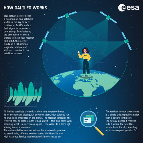 Image:
How Galileo works - infographic
Image:
How Galileo works - infographic
HydroGNSS twice as good
6.3.2023 14:57 ESA Observing the Earth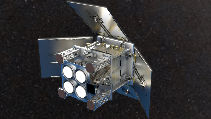
ESA’s HydroGNSS mission will now comprise two identical satellites to halve the time it takes to revisit the same place on Earth’s surface and re-measure various climate variables such soil moisture. Having two satellites in orbit will significantly improve the science that this exciting new Scout mission will yield.
20230306 - Upozornění na tiskovou chybu v publikaci ÚZ č. 1530
6.3.2023 13:55 ČÚZK - předpisy a opatření Český úřad zeměměřický a katastrální zveřejnil novou aktualitu: ČÚZK upozorňuje na tiskovou chybu v publikaci ÚZ č. 1530 „KATASTR NEMOVITOSTÍ, ZEMĚMĚŘICTVÍ, POZEMKOVÉ ÚPRAV A ÚŘADY“ vydané nakladatelstvím Sagit, a.s. s redakční uzávěrkou k 1. 2.2023. V této publikaci jsou nesprávné údaje na stránkách 83 a 88. Správné znění těchto stránek je se svolením nakladatelství k dispozici zde.20230306 - Upozornění na tiskovou chybu v publikaci ÚZ č. 1530
6.3.2023 13:55 ČÚZK /Aktuality-resort/2023/Upozorneni-na-tiskovou-chybu-v-publikaci-UZ-c-153020230306 - Upozornění na tiskovou chybu v publikaci ÚZ č. 1530
6.3.2023 13:55 ČÚZK - aktuality v resortu ČÚZK upozorňuje na tiskovou chybu v publikaci ÚZ č. 1530 „KATASTR NEMOVITOSTÍ, ZEMĚMĚŘICTVÍ, POZEMKOVÉ ÚPRAV A ÚŘADY“ vydané nakladatelstvím Sagit, a.s. s redakční uzávěrkou k 1. 2.2023. V této publikaci jsou nesprávné údaje na stránkách 83 a 88. Správné znění těchto stránek je se svolením nakladatelství k dispozici zde.20230306 - Upozornění na tiskovou chybu v publikaci ÚZ č. 1530
6.3.2023 13:55 ČÚZK - aktuality v resortu ČÚZK upozorňuje na tiskovou chybu v publikaci ÚZ č. 1530 „KATASTR NEMOVITOSTÍ, ZEMĚMĚŘICTVÍ, POZEMKOVÉ ÚPRAV A ÚŘADY“ vydané nakladatelstvím Sagit, a.s. s redakční uzávěrkou k 1. 2.2023. V této publikaci jsou nesprávné údaje na stránkách 83 a 88. Správné znění těchto stránek je se svolením nakladatelství k dispozici zde.Nové verze 16.13
6.3.2023 12:00 GEPROPřipravili jsme pro vás nové verze 16.13 našich produktů. Stahovat je můžete z obvyklého umístění na našem download serveru. Novinky, které jsme pro vás nachystali: KOKEŠ MISYS PROLAND KOKEŠ Geodetické funkce Vytyčovací prvky: do záznamu výpočtu doplněn výpis délky a směrníku měřické přímky. Geometrické plány Export změnových vět VFK: lze exportovat měněné souřadnice polohy u …
Nové verze 16.13 Pokračovat ve čtení »
Článek Nové verze 16.13 se nejdříve objevil na GEPRO.
Nové verze 16.13
6.3.2023 12:00 GEPROPřipravili jsme pro vás nové verze 16.13 našich produktů. Stahovat je můžete z obvyklého umístění na našem download serveru. Novinky, které jsme pro vás nachystali: KOKEŠ MISYS PROLAND KOKEŠ Geodetické funkce Vytyčovací prvky: do záznamu výpočtu doplněn výpis délky a směrníku měřické přímky. Geometrické plány Export změnových vět VFK: lze exportovat měněné souřadnice polohy u …
Nové verze 16.13 Pokračovat ve čtení »
Článek Nové verze 16.13 se nejdříve objevil na GEPRO.
Aktualizace otevřených dat zastávek veřejné dopravy v Jihočeském kraji
6.3.2023 10:53 Jihočeský krajV sekci Doprava a silniční hospodářství byla aktualizována data zastávek veřejné dopravy v Jihočeském kraji k 6.3.2023. Data jsou k dispozici ke stažení pod licencí CC0 nebo pomocí webových služeb (WMS) či k zobrazení v mapové aplikaci.
výběrové řízení na KÚ pro Vysočinu
6.3.2023 10:17 ČÚZK - předpisy a opatření Katastrální úřad pro Vysočinu zveřejnil novou aktualitu: Oznámení o vyhlášení výběrového řízení na služební místo odborný referent/vrchní referent v personálním oddělení Kanceláře ředitele katastrálního úřadu na Katastrálním úřadu pro Vysočinu.TurboCAD Designer 28 CZ – ohromí Vás skvělým poměrem výkonu / ceny.
5.3.2023 18:17 ŠPINAR - softwareTurboCAD Deluxe 28 CZ v akční ceně do 12. 3. 2022,
The post TurboCAD Designer 28 CZ – ohromí Vás skvělým poměrem výkonu / ceny. appeared first on ŠPINAR – software.
TurboCAD Designer 28 CZ – pro kreslení přesných projektů ve 2D
5.3.2023 18:17 ŠPINAR - softwareTurboCAD Designer 28 CZ v akční ceně do 19. 3. 2023,
The post TurboCAD Designer 28 CZ – pro kreslení přesných projektů ve 2D appeared first on ŠPINAR – software.
TurboCAD Designer 28 CZ – pro kreslení přesných projektů ve 2D
5.3.2023 18:17 ŠPINAR - softwareTurboCAD Deluxe 28 CZ v akční ceně do 12. 3. 2022,
The post TurboCAD Designer 28 CZ – pro kreslení přesných projektů ve 2D appeared first on ŠPINAR – software.
OpenBIM for Occupant Movement Analysis Industry Report
3.3.2023 20:00 buildingSMART.orgThe OMA project team – part of the wider project on Fire Safety Engineering – has published an Industry Report on use cases relating to openBIM and OMA. Please click…
The post OpenBIM for Occupant Movement Analysis Industry Report appeared first on buildingSMART International.
Mapová aplikace ÚPD - nové dokumentace
3.3.2023 13:11 Jihočeský krajV mapové aplikaci Územně plánovací dokumentace obcí byla aktualizována ÚPD obcí ORP Trhové Sviny – Trhové Sviny, ORP Prachatice – Stožec, Bohunice, ORP Č. Krumlov – Mirkovice, ORP Třeboň - Halámky.
Earth from Space: Poyang Lake, China
3.3.2023 10:00 ESA Observing the Earth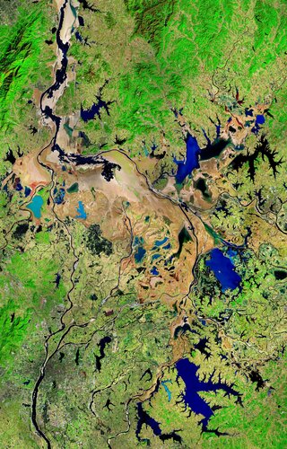 Image:
This Copernicus Sentinel-2 image shows Poyang Lake in China’s Jiangxi Province during winter.
Image:
This Copernicus Sentinel-2 image shows Poyang Lake in China’s Jiangxi Province during winter.
Vrchní referent / rada – správa dokumentace katastru v oddělení dokumentace KN Katastrálního pracovi
2.3.2023 9:32 ČÚZK - volná místa Katastrální úřad pro Zlínský kraj Katastrální pracoviště Zlín vypisuje výběrové řízení na místo Vrchní referent / rada – správa dokumentace katastru v oddělení dokumentace KN Katastrálního pracoviVrchní referent / rada – správa dokumentace katastru v oddělení dokumentace KN Katastrálního pracovi
2.3.2023 9:32 ČÚZK - předpisy a opatření Katastrální úřad pro Zlínský kraj Katastrální pracoviště Zlínvypisuje výběrové řízení na místo
Vrchní referent / rada – správa dokumentace katastru v oddělení dokumentace KN Katastrálního pracoviště Zlín
Vrchní referent / rada – správa dokumentace katastru v oddělení dokumentace KN Katastrálního pracovi
2.3.2023 9:32 ČÚZK /Urady/Katastralni-urady/Katastralni-urady/Katastralni-urad-pro-Zlinsky-kraj/Uredni-deska/Oznameni-a-jina-uredni-sdeleni/Volna-mista/DMS/Vrchni-referent-rada-–-sprava-dokumentace-katastru20230302 - Výroční zpráva
2.3.2023 8:40 ČÚZK - aktuality v resortu Zveřejněna Výroční zpráva Českého úřadu zeměměřického a katastrálního za rok 2022.20230302 - Výroční zpráva
2.3.2023 8:40 ČÚZK - předpisy a opatření Český úřad zeměměřický a katastrální zveřejnil novou aktualitu: Zveřejněna Výroční zpráva Českého úřadu zeměměřického a katastrálního za rok 2022.Výroční souhrnná resortní zpráva za rok 2022
2.3.2023 8:37 ČÚZK - předpisy a opatření Český úřad zeměměřický a katastrálnívydává výroční zprávu úřadu za rok
2022
Rozpočet úřadu za rok 2023
2.3.2023 6:39 ČÚZK - předpisy a opatření Katastrální úřad pro Vysočinuvystavuje rozpočet úřadu za rok
2023
Rozpočet úřadu za rok 2023
2.3.2023 6:39 ČÚZK /Urady/Katastralni-urady/Katastralni-urady/Katastralni-urad-pro-Vysocinu/Rozpocet/Rozpocet-uradu-za-rok-2023TurboCAD Deluxe 28 CZ
1.3.2023 19:36 ŠPINAR - softwareTurboCAD Deluxe 28 CZ v akční ceně do 12. 3. 2022,
The post TurboCAD Deluxe 28 CZ appeared first on ŠPINAR – software.
TurboCAD Deluxe 28 CZ – ohromí skvělým poměrem výkonu / ceny
1.3.2023 19:36 ŠPINAR - softwareTurboCAD Deluxe 28 CZ v akční ceně do 12. 3. 2023,
The post TurboCAD Deluxe 28 CZ – ohromí skvělým poměrem výkonu / ceny appeared first on ŠPINAR – software.
TurboCAD Deluxe 28 CZ v akční ceně!
1.3.2023 19:36 ŠPINAR - softwareTurboCAD Deluxe 28 CZ v akční ceně do 12. 3. 2022,
The post TurboCAD Deluxe 28 CZ v akční ceně! appeared first on ŠPINAR – software.
TurboCAD Deluxe 28 CZ – ohromí skvělým poměrem výkonu / ceny
1.3.2023 19:36 ŠPINAR - software TurboCAD Deluxe 28 CZ v akční ceně do 12. 3. 2023,TurboCAD Deluxe 28 CZ – ohromí skvělým poměrem výkonu / ceny
1.3.2023 19:36 ŠPINAR - softwareTurboCAD Deluxe 28 CZ v akční ceně do 12. 3. 2022,
The post TurboCAD Deluxe 28 CZ – ohromí skvělým poměrem výkonu / ceny appeared first on ŠPINAR – software.
TurboCAD Deluxe 28 CZ v akční ceně!
1.3.2023 19:36 ŠPINAR - softwareTurboCAD Deluxe 28 CZ v akční ceně do 12. 3. 2022,
The post TurboCAD Deluxe 28 CZ v akční ceně! appeared first on ŠPINAR – software.
TurboCAD Designer 28 CZ – kreslení projektů ve 2D – formáty DWG, DXF…
1.3.2023 19:36 ŠPINAR - softwareTurboCAD Deluxe 28 CZ v akční ceně do 12. 3. 2022,
The post TurboCAD Designer 28 CZ – kreslení projektů ve 2D – formáty DWG, DXF… appeared first on ŠPINAR – software.
TurboCAD Deluxe 28 CZ – ohromí Vás skvělým poměrem výkonu / ceny.
1.3.2023 19:36 ŠPINAR - softwareTurboCAD Deluxe 28 CZ v akční ceně do 12. 3. 2022,
The post TurboCAD Deluxe 28 CZ – ohromí Vás skvělým poměrem výkonu / ceny. appeared first on ŠPINAR – software.
VR do 15.3. rada/odborný rada
1.3.2023 15:57 ČÚZK - předpisy a opatření Katastrální úřad pro hlavní město Prahu zveřejnil novou aktualitu: VŘ na služební místo odborný referent/vrchní referent Ředitelka úřadu vyhlašuje výběrové řízení na služební místo:referent/vrchní referent – informační a kontrolní pracovník
VR do 15.5. referent/vrchní referent – informační a kontrolní pracovník
1.3.2023 15:57 ČÚZK - předpisy a opatření Katastrální úřad pro hlavní město Prahu zveřejnil novou aktualitu: VŘ na služební místo odborný referent/vrchní referent Ředitelka úřadu vyhlašuje výběrové řízení na služební místo:referent/vrchní referent – informační a kontrolní pracovník
VR do 15.3. rada/odborný rada
1.3.2023 15:57 ČÚZK - předpisy a opatření Katastrální úřad pro hlavní město Prahu zveřejnil novou aktualitu: VŘ na služební místo odborný referent/vrchní referent Ředitelka úřadu vyhlašuje výběrové řízení na služební místo:referent KN – zápis do protokolu řízení V a Z
VR do 15.5. referent/vrchní referent – informační a kontrolní pracovník
1.3.2023 15:57 ČÚZK /Urady/Katastralni-urady/Katastralni-urady/Katastralni-urad-pro-hlavni-mesto-Prahu/O-uradu/Aktuality/VR-do-15-3-rada-odborny-radaVR do 15.3. rada/odborný rada
1.3.2023 15:57 ČÚZK /Urady/Katastralni-urady/Katastralni-urady/Katastralni-urad-pro-hlavni-mesto-Prahu/O-uradu/Aktuality/VR-do-15-3-rada-odborny-radaVR do 15.5. referent/vrchní referent – informační a kontrolní pracovník
1.3.2023 15:57 ČÚZK - předpisy a opatření Katastrální úřad pro hlavní město Prahu zveřejnil novou aktualitu: VŘ na služební místo odborný referent/vrchní referent Ředitelka úřadu vyhlašuje výběrové řízení na služební místo:referent/vrchní referent – informační a kontrolní
pracovník
referent/vrchní referent
1.3.2023 15:38 ČÚZK - předpisy a opatření Katastrální úřad pro hlavní město Prahuvypisuje výběrové řízení na místo
referent/vrchní referent
referent/vrchní referent
1.3.2023 15:38 ČÚZK - volná místa Katastrální úřad pro hlavní město Prahu vypisuje výběrové řízení na místo referent/vrchní referentreferent/vrchní referent
1.3.2023 15:38 ČÚZK /Urady/Katastralni-urady/Katastralni-urady/Katastralni-urad-pro-hlavni-mesto-Prahu/Uredni-deska/Oznameni-a-jina-uredni-sdeleni/Volna-mista/DMS/referent-vrchni-referentvýběrové řízení na KP Jihlava
1.3.2023 14:06 ČÚZK - předpisy a opatření Katastrální úřad pro Vysočinu - Katastrální pracoviště Jihlava zveřejnil novou aktualitu: Oznámení o vyhlášení výběrového řízení na místo odborný referent v oddělení dokumentace katastru nemovitostí Katastrálního pracoviště Jihlavaodborný-vrchní referent dokumentace KN KP JI
1.3.2023 13:43 ČÚZK /Urady/Katastralni-urady/Katastralni-urady/Katastralni-urad-pro-Vysocinu/Volna-mista/DMS/odborny-vrchni-referent-dokumentace-KN-KP-JIodborný-vrchní referent dokumentace KN KP JI
1.3.2023 13:43 ČÚZK - předpisy a opatření Katastrální úřad pro Vysočinu Katastrální pracoviště Jihlavavypisuje výběrové řízení na místo
odborný-vrchní referent dokumentace KN KP JI
odborný-vrchní referent dokumentace KN KP JI
1.3.2023 13:43 ČÚZK - volná místa Katastrální úřad pro Vysočinu Katastrální pracoviště Jihlava vypisuje výběrové řízení na místo odborný-vrchní referent dokumentace KN KP JIPřerušení provozu DP a WSDP v úterý 7.3.2023 od 18:00 do cca 20:00.
1.3.2023 13:26 ČÚZK /Aplikace-DP-do-KN/Aplikace-DP-do-KN/Archiv-DP/379921Přerušení provozu DP a WSDP v úterý 7.3.2023 od 18:00 do cca 20:00.
1.3.2023 13:26 Dálkový přístup k údajům KN ČR Vážení uživatelé,oznamujeme, že v úterý 7.3.2023 od 18:00 bude z provozních důvodů zcela přerušen provoz Dálkového přístupu i Webových služeb dálkového přístupu. Obnovení provozu předpokládáme v cca 20 hodin. U této verze nedochází ke změnám webových služeb.
Za komplikace tímto způsobené se omlouváme a děkujeme za pochopení.
Přerušení provozu DP a WSDP v úterý 7.3.2023 od 18:00 do cca 20:00.
1.3.2023 13:26 ČÚZK - předpisy a opatření Vážení uživatelé,oznamujeme, že v úterý 7.3.2023 od 18:00 bude z provozních důvodů zcela přerušen provoz Dálkového přístupu i Webových služeb dálkového přístupu. Obnovení provozu předpokládáme v cca 20 hodin. U této verze nedochází ke změnám webových služeb.
Za komplikace tímto způsobené se omlouváme a děkujeme za pochopení.
Omezení provozu
1.3.2023 9:14 ČÚZK - předpisy a opatření Katastrální úřad pro Jihočeský kraj zveřejnil novou aktualitu: Upozorňujeme na omezení provozu 27.3.2023 v důsledku odstávky elektrické energie.Omezení provozu
1.3.2023 9:14 ČÚZK - předpisy a opatření Katastrální úřad pro Jihočeský kraj zveřejnil novou aktualitu: Upozorňujeme na omezení provozu 15. a 27.3.2023 v důsledku odstávky elektrické energie.Omezení provozu
1.3.2023 9:11 ČÚZK /Urady/Katastralni-urady/Katastralni-urady/Katastralni-urad-pro-Jihocesky-kraj/Katastralni-pracoviste/KP-Ceske-Budejovice/O-uradu/Aktuality/Omezeni-provozuOmezení provozu
1.3.2023 9:11 ČÚZK - předpisy a opatření Katastrální úřad pro Jihočeský kraj - Katastrální pracoviště České Budějovice zveřejnil novou aktualitu: Upozorňujeme na omezení provozu 27.3.2023 v důsledku odstávky elektrické energie.Omezení provozu
1.3.2023 9:11 ČÚZK - předpisy a opatření Katastrální úřad pro Jihočeský kraj - Katastrální pracoviště České Budějovice zveřejnil novou aktualitu: Upozorňujeme na omezení provozu 15. a 27.3.2023 v důsledku odstávky elektrické energie.Nedostupné produkční ISÚI a VDP
1.3.2023 6:58 ČÚZK /ruian/Editacni-agendovy-system-ISUI/Provozni-informace-a-odstavky/Archiv-PROD/Nedostupne-produkcni-ISUI-a-VDP-(4)Final workshop for OSNMA Public Observation Test Phase
28.2.2023 12:45 European GNSS Agency
The OSNMA is a new, breakthrough feature of Europe’s positioning system that meets a clear user need: improve the trustworthiness of GNSS signals. This service provides an authentication mechanism to allow Open Service users to verify that the navigation data received come from Galileo and have not been modified in any way.
To acquaint interested receiver manufacturers and application developers with the Galileo OSNMA functionalities, EUSPA and the European Commission have been engaging with users through a Public Observation Test. Over the past two years, manufacturers and integrators in the GNSS industry have had the opportunity to thoroughly test Galileo's OSNMA service through the use of Signal in Space (SiS) in various scenarios tailored to their target use cases. This testing phase has also provided valuable insights and allowed for a productive exchange of views with industry experts, all while assessing the performance of the OSNMA service.
Check this out: Tests of Galileo OSNMA underway
Industry embraces Galileo OSNMA
The Public Observation Final Workshop was welcomed with a great enthusiasm with participants praising the significant value that the service has added and the vast possibilities it is opening up.
During the test phase, the Galileo constellation performed excellently, with signal availability exceeding 90% in urban and 80% in deep urban environments, respectively.
"Through the various consultations we had with the industry, it became evident that robustness and innovation are the main competitive advantages of the service. To date, Galileo is the only GNSS to offer such a feature’’ says Flavio Sbardellati, EUSPA Market Development Technology Officer. "A very important outcome of our interactions was that OSNMA is an ‘’easy to sell’’ service with numerous benefits across various industries.
Several leading receiver manufacturers across the EU now confirm the readiness of the OSNMA with Ublox, TeleOrbit and Fraunhofer IIS preparing to include this new Galileo feature in their platforms. System integrators such as Safran Electronics & Defence (formally Orolia) view the OSNMA as a means to reinforce their unique selling proposition while the Norwegian Metrology Service is considering it for timing and synchronisation purposes.
One of the most promising sectors is undeniably mobility with international mobility service provider Sixt highlighting the importance of OSNMA in ride-hailing and car-sharing applications.
OSNMA can provide added value to smartphone users too. Airbus Defence and Space confirms that mass market chipsets are making steady progress towards enabling the processing of OSNMA data via Android API, presenting a promising opportunity for wider adoption.
A possible solution to bring OSNMA into smartphones has been presented by Qascom, a leading company in GNSS authentication. Through assistance data, it is possible to provide improved performance, simple implementation, and a hot start in any condition.
Read this: One step closer to OSNMA: SIS ICD and Receiver Guidelines just released
OSNMA contributes to European security and resilience
In the last year and in the current geopolitical context, an increasing number of jamming and spoofing incidents have been recorded by the GNSS community. For instance, the European Aviation Safety Agency has reported numerous events of signal outages or distortions in geographical areas surrounding the conflict zone areas.
GNSS signal falsification or denial can have disastrous impacts on applications and market sectors that rely on precise and reliable position, navigation, and timing information. The global economy could suffer tremendous losses in case of GNSS outages caused by various attacks such as spoofing.
"Galileo is an instrumental component of the EU Space Programme and a crucial asset contributing to the autonomy and resilience of the Union as well as the safety of its citizens. Its authentication service, OSNMA, is a real differentiator to position a stronger system worldwide that we, Europeans, achieved together'', says EUSPA Chief Operating Officer, Pascal Claudel.
OSNMA provides a first layer of authentication to GNSS with minimal impact on the receiver side and is completely free for the final users. The Galileo Open Service Navigation Message Authentication is expected to become operational within 2023.
Media note: This feature can be republished without charge provided the European Union Agency for the Space Programme (EUSPA) is acknowledged as the source at the top or the bottom of the story. You must request permission before you use any of the photographs on the site. If you republish, we would be grateful if you could link back to the EUSPA website (http://www.euspa.europa.eu).
Final workshop for OSNMA Public Observation Test Phase
28.2.2023 12:45 European GNSS AgencyThe OSNMA is a new, breakthrough feature of Europe’s positioning system that meets a clear user need: improve the trustworthiness of GNSS signals. This service provides an authentication mechanism to allow Open Service users to verify that the navigation data received come from Galileo and have not been modified in any way.
To acquaint interested receiver manufacturers and application developers with the Galileo OSNMA functionalities, EUSPA and the European Commission have been engaging with users through a Public Observation Test Phase. Over the past two years, manufacturers and integrators in the GNSS industry have had the opportunity to thoroughly test Galileo's OSNMA service through the use of Signal in Space (SiS) in various scenarios tailored to their target use cases. This testing phase has also provided valuable insights and allowed for a productive exchange of views with industry experts, all while assessing the performance of the OSNMA service. The Public Observation Test Phase will continue to be active till the Service Declaration.
Check this out: Tests of Galileo OSNMA underway
Industry embraces Galileo OSNMA
The Public Observation Final Workshop was welcomed with a great enthusiasm with participants praising the significant value that the service has added and the vast possibilities it is opening up.
During the test phase, the Galileo constellation performed excellently, with signal availability exceeding 90% in urban and 80% in deep urban environments, respectively.
"Through the various consultations we had with the industry, it became evident that robustness and innovation are the main competitive advantages of the service. To date, Galileo is the only GNSS to offer such a feature’’ says Flavio Sbardellati, EUSPA Market Development Technology Officer. "A very important outcome of our interactions was that OSNMA is an ‘’easy to sell’’ service with numerous benefits across various industries.
Several leading receiver manufacturers across the EU now confirm the readiness of the OSNMA with Ublox, TeleOrbit and Fraunhofer IIS preparing to include this new Galileo feature in their platforms. System integrators such as Safran Electronics & Defence (formally Orolia) view the OSNMA as a means to reinforce their unique selling proposition while the Norwegian Metrology Service is considering it for timing and synchronisation purposes.
One of the most promising sectors is undeniably mobility with international mobility service provider Sixt highlighting the importance of OSNMA in ride-hailing and car-sharing applications.
OSNMA can provide added value to smartphone users too. Airbus Defence and Space confirms that mass market chipsets are making steady progress towards enabling the processing of OSNMA data via Android API, presenting a promising opportunity for wider adoption.
A possible solution to bring OSNMA into smartphones has been presented by Qascom, a leading company in GNSS authentication. Through assistance data, it is possible to provide improved performance, simple implementation, and a hot start in any condition.
Read this: One step closer to OSNMA: SIS ICD and Receiver Guidelines just released
OSNMA contributes to European security and resilience
In the last year and in the current geopolitical context, an increasing number of jamming and spoofing incidents have been recorded by the GNSS community. For instance, the European Aviation Safety Agency has reported numerous events of signal outages or distortions in geographical areas surrounding the conflict zone areas.
GNSS signal falsification or denial can have disastrous impacts on applications and market sectors that rely on precise and reliable position, navigation, and timing information. The global economy could suffer tremendous losses in case of GNSS outages caused by various attacks such as spoofing.
"Galileo is an instrumental component of the EU Space Programme and a crucial asset contributing to the autonomy and resilience of the Union as well as the safety of its citizens. Its authentication service, OSNMA, is a real differentiator to position a stronger system worldwide that we, Europeans, achieved together'', says EUSPA Chief Operating Officer, Pascal Claudel.
OSNMA provides a first layer of authentication to GNSS with minimal impact on the receiver side and is completely free for the final users. The Galileo Open Service Navigation Message Authentication is expected to become operational within 2023.
Media note: This feature can be republished without charge provided the European Union Agency for the Space Programme (EUSPA) is acknowledged as the source at the top or the bottom of the story. You must request permission before you use any of the photographs on the site. If you republish, we would be grateful if you could link back to the EUSPA website (http://www.euspa.europa.eu).
Krátka správa č. 10/2023
28.2.2023 12:42 Komora geodetů a kartografů SRThe post Krátka správa č. 10/2023 appeared first on Komora geodetov a kartografov.
20230228_Odborný rada oddělení právních vztahů k nemovitostem
28.2.2023 10:56 ČÚZK /Urady/Katastralni-urady/Katastralni-urady/Katastralni-urad-pro-Stredocesky-kraj/Katastralni-pracoviste/KP-Rakovnik/O-uradu/Aktuality/20230111_Odborny-rada-oddeleni-pravnich-vztahu-(2)20230228_Odborný rada oddělení právních vztahů k nemovitostem
28.2.2023 10:56 ČÚZK - předpisy a opatření Katastrální úřad pro Středočeský kraj - Katastrální pracoviště Rakovník Vyhlášení výběrového řízení: odborný rada oddělení právních vztahů k nemovitostem V části "Úřední deska", v sekci "Oznámení a jiná úřední sdělení" bylo vystaveno "Oznámení o vyhlášení výběrového řízení na obsazení služebního místa odborný rada oddělení právních vztahů k nemovitostem"Can we halve the use of pesticides in the EU by 2030?
28.2.2023 10:10 European GNSS Agency
Pesticides and fertilisers can be important tools in modern farming. When used correctly, fertilisers provide essential nutrients for crop growth, while pesticides can help protect those crops from harmful pests and diseases.
The problem is that agriculture has become too dependent on both. Instead of being applied when and where they’re needed, it’s become standard practice to blanket an entire field with fertilisers and pesticides. In fact, it is estimated that farmers worldwide use 5.6 billion pounds of pesticides every year – an overapplication that has wreaked havoc on the environment.
Not only does the unmanaged use of pesticides and fertilisers contaminate soil and water, it threatens biodiversity, food security and even human health. “It’s time to change course on how we use pesticides in the EU,” says Stella Kyriakides, European Commissioner for Health and Food Safety. “We need to reduce the use of chemical pesticides to protect our soils, air, food and, ultimately, the health of our citizens.”
This is why, as part of its Green Deal initiative, the European Commission has proposed to cut the use of pesticides in half by 2030. Today’s farmers are being asked to increase productivity and reduce the environmental impact of their activities, both without compromising on quality,” says EUSPA Executive Director Rodrigo da Costa. “With EU Space technologies, they can achieve these challenges.”
Enabling the variable rate application of pesticides
For SatAgro, striking this balance between productivity and sustainability starts with Copernicus, Europe’s Earth Observation programme. The Polish company offers a far-ranging, automated web-based service for precision agriculture supported by satellite observations.
“SatAgro’s mission is to provide up-to-date information on crop conditions and its variability in space and time so users can optimise their decision making, implement precision and regenerative farming techniques, and become more profitable in the process,” says SatAgro Founder and Chief Development Officer Przemysław Żelazowski.
To do this, the company uses Copernicus Sentinel data to measure soil quality, distinguish between crop types, and monitor the health and maturity of their yields, amongst other uses. Access to such data can help farmers increase yields and productivity while also reducing their environmental impact.
Farmers benefit in multiple ways from the use of Copernicus data. For example, by being able to ‘see’ which crops would benefit most from the use of pesticides, they can apply pesticides to just those crops – resulting in significant costs savings and potential increases in yields.
In agriculture, this is called variable rate application. Instead of the uniform application of chemicals across entire fields, with variable rate application, farmers can apply appropriate amounts of fertilisers and pesticides at a precise time and/or location.
This is where another component of the EU Space Programme comes into play: European GNSS (EGNSS). Whereas Earth Observation shows you where pesticides and fertilisers are needed, the precise positioning provided by Galileo and EGNOS guides your machinery to that exact location.
“The electronic dosage instructions for fertilisers and other agrochemicals compiled by the SatAgro solution are compatible with most of the major EGNSS-enabled precision spreaders and sprayers on the market,” adds Żelazowski.
When less is more
Put Earth Observation and EGNSS together and what you get is a very powerful solution for the variable rate application of fertilisers and pesticides. Copernicus provides differentiated mapping of crops and EGNSS the highly accurate positioning of machinery. Together, they allow farmers to precisely apply fertilisers and pesticides only when and where they are needed most.
Learn more: EU Space for smart farming and sustainable agriculture
But the benefits of EU Space technologies aren’t limited to the sustainable use of fertilisers and pesticides. This same technology can be used to reduce the fuel used by farm equipment, install smart irrigation systems, implement best practices in time management, increase productivity, mitigate the impact of climate change, and optimise yields – all with minimal investments by the farmer.
“Leveraging the synergies created by the tandem use of Earth Observation and EGNSS, a new frontier for agriculture will soon be a reality,” concludes da Costa. “Smart data will enable ‘a less is more’ approach – with less fuel, water and chemicals, agriculture will evolve into a more efficient, profitable and sustainable sector.”
Media note: This feature can be republished without charge provided the European Union Agency for the Space Programme (EUSPA) is acknowledged as the source at the top or the bottom of the story. You must request permission before you use any of the photographs on the site. If you republish, we would be grateful if you could link back to the EUSPA website (http://www.euspa.europa.eu).
Nová verze Holixa T4R v3.4.3 – doplňková sada nástrojů pro Revit
28.2.2023 8:00 Arkance SystemsArkance Systems uvádí novou verzi aplikace Holixa T4R pro Autodesk Revit - nový nástroj Správce podlaží a několik vylepšení.
Zpráva Nová verze Holixa T4R v3.4.3 – doplňková sada nástrojů pro Revit pochází z arkance-systems.cz.
Nová verze Holixa T4R v3.4.3 – doplňková sada nástrojů pro Revit
28.2.2023 8:00 Arkance SystemsUvádíme novou verzi aplikace Holixa T4R pro Autodesk Revit - nový nástroj Správce podlaží a několik vylepšení.
Zpráva Nová verze Holixa T4R v3.4.3 – doplňková sada nástrojů pro Revit pochází z arkance-systems.cz.
84. setkání pražských fotogrammetrů a členů SFDP
27.2.2023 21:23 Společnost pro fotogrammetrii a dálkový průzkum84. setkání pražských fotogrammetrů a členů SFDP proběhlo tentokrát netradičně. Reagovali jsme na nabídku Jardy Pollerta zorganizovat rafting v “Loděnici Troja“ a 9. 8. 2022, od 15,30 jsme si dali sraz v restauraci „Loděnice Troja“. Následovalo zhruba ½ hodinové bezpečnostní školení a také nám byly zapůjčeny: neopren a boty, helma, vesta, pádlo. Rafting probíhal zhruba 2 hod. a byl pro všechny účastníky velkou výzvou plnou náročných překvapení. Po absolvování raftu jsme si v průběhu večeře vzájemně vyměnili nově získané zkušenosti. Moc děkujeme Jardovi za organizaci této zcela mimořádné akce.
The post 84. setkání pražských fotogrammetrů a členů SFDP appeared first on SFDP.