


![]()

zprávy
zdroje zpráv:Prodej nepotřebné měřící techniky
27.10.2022 14:15 ČÚZK - předpisy a opatření Katastrální úřad pro Plzeňský kraj - Katastrální pracoviště Plzeň-město zveřejnil novou aktualitu: nabídka na prodej nepotřebné měřící technikyProdej nepotřebné měřící techniky
27.10.2022 14:11 ČÚZK /Urady/Katastralni-urady/Katastralni-urady/Katastralni-urad-pro-Plzensky-kraj/Nabidky-majetku/Prodej-nepotrebne-merici-technikyProdej nepotřebné měřící techniky
27.10.2022 14:11 ČÚZK - předpisy a opatřeníKatastrální úřad pro Plzeňský kraj - Katastrální pracoviště Plzeň-město nabízí nepotřebný majetek k odkupu. Jedná se o
Prodej nepotřebné měřící techniky
Faster and more robust: three I/NAV improvements to upgrade the Galileo Open Service
27.10.2022 11:51 European GNSS Agency
The Galileo Open Service (OS) is being upgraded with three new features being added to the I/NAV message, which is one of four message types broadcast by Galileo satellites. Collectively referred to simply as I/NAV improvements, these features will be available free of charge to all Open Service users.
“EUSPA is committed to continuously improving the Galileo Open Service,” says Guerric Pont, Galileo Exploitation Programme Manager. “With I/NAV improvements, users can considerably boost their experience when using Galileo OS, thanks, for example, to the improved performance in terms of time to first fix.”
Whilst ensuring full backward compatibility with existing Galileo receivers, the three new features will also improve the robustness of Galileo OS when receiving navigation data, particularly in challenging environments.
Faster positioning
The features will enhance the Open Service’s ability to resolve user clock uncertainty, which will reduce the time it takes to receive Clock and Ephemeris Data (CED). For example, by improving time-to-CED, the Reduced Clock Ephemeris Data (RedCED) and Reed-Solomon Outer Forward Error Correction (RS FEC2) features will reduce the overall Time to First Fix (TTFF).
“In many conditions, the time it takes to receive clock corrections and ephemeris data has a major impact on TTFF,” adds Guerric Pont. “By reducing this time, these features will benefit all applications that require reception of this data from the navigation signals.”
Benefiting applications working in GNSS-assisted mode
The improvements will also benefit applications working in GNSS-assisted mode. In this mode, when navigation data is received from non-GNSS channels and the receiver’s knowledge of the Galileo System Time is affected by a relatively large error, typically in the order of a few seconds, the clock uncertainty must be resolved quickly and stably.
With the I/NAV improvements, receivers will be able to do this via the new Secondary Synchronisation Patterns (SSP) feature.
Deployment plan on going
I/NAV improvements are being gradually implemented into the existing Galileo constellation through satellite software upgrades, which allow individual satellites to be successively upgraded with the new features. After a satellite has been upgraded, the improvements will be openly accessible through the I/NAV message carried by the E1-B signal.
Media note: This feature can be republished without charge provided the European Union Agency for the Space Programme (EUSPA) is acknowledged as the source at the top or the bottom of the story. You must request permission before you use any of the photographs on the site. If you republish, we would be grateful if you could link back to the EUSPA website (http://www.euspa.europa.eu).
Aktualizace otevřených dat zastávek veřejné dopravy v Jihočeském kraji
27.10.2022 10:10 Jihočeský krajV sekci Doprava a silniční hospodářství byla aktualizována data zastávek veřejné dopravy v Jihočeském kraji. Aktualizace dat probíhaly od června do října 2022 na základě terénního průzkumu, kde byl zjišťován stav a umístění označníků zastávek autobusové dopravy, díky kterému byla zpřesněna jejich poloha. Zpřesnění polohy se týká 1016 označníků. Data jsou k dispozici ke stažení pod licencí CC0 nebo pomocí webových služeb (WMS) či k zobrazení v mapové aplikaci.
Hub4Everybody technologie pro dnešek / Map WhiteBoard technologie pro zítřek (pozvánka)
27.10.2022 8:53 GISportal.cz
Hromadí se ve vašem počítači různé digitální mapy? Například výsledky studentských prací, pocitové mapy lokalit, výsledky terénních průzkumů nebo vědeckých experimentů? Chcete výsledky vašich aktivit zveřejnit, propagovat nebo je diskutovat napříč různými cílovými skupinami? V tom případě je zde pro Vás tematický seminář, kde představíme platformu a technologické možnosti zpracování a využití digitálních map, práci […]
The post Hub4Everybody technologie pro dnešek / Map WhiteBoard technologie pro zítřek (pozvánka) appeared first on GISportal.cz.
Hub4Everybody technologie pro dnešek / Map WhiteBoard technologie pro zítřek (pozvánka)
27.10.2022 8:53 GISportal.czHromadí se ve vašem počítači různé digitální mapy? Například výsledky studentských prací, pocitové mapy lokalit, výsledky terénních průzkumů nebo vědeckých experimentů? Chcete výsledky vašich aktivit zveřejnit, propagovat nebo je diskutovat napříč různými cílovými skupinami? V tom případě je zde pro Vás tematický seminář, kde představíme platformu a technologické možnosti zpracování a využití digitálních map, práci […]
The post Hub4Everybody technologie pro dnešek / Map WhiteBoard technologie pro zítřek (pozvánka) appeared first on GISportal.cz.
Přerušení provozu DP a WSDP v pondělí 31.10.2022 od 20:30 do cca 22:00.
27.10.2022 1:44 ČÚZK /Aplikace-DP-do-KN/Aplikace-DP-do-KN/Archiv-DP/369479Přerušení provozu DP a WSDP v pondělí 31.10.2022 od 20:30 do cca 22:00.
27.10.2022 1:44 ČÚZK - předpisy a opatření Vážení uživatelé,oznamujeme, že v pondělí 31.10.2022 od 20:30 bude z provozních důvodů zcela přerušen provoz Dálkového přístupu i Webových služeb dálkového přístupu. Obnovení provozu předpokládáme v cca 22 hodin. U této verze nedochází ke změnám webových služeb.
Za komplikace tímto způsobené se omlouváme a děkujeme za pochopení.
Přerušení provozu DP a WSDP v pondělí 31.10.2022 od 20:30 do cca 22:00.
27.10.2022 1:44 Dálkový přístup k údajům KN ČR Vážení uživatelé,oznamujeme, že v pondělí 31.10.2022 od 20:30 bude z provozních důvodů zcela přerušen provoz Dálkového přístupu i Webových služeb dálkového přístupu. Obnovení provozu předpokládáme v cca 22 hodin. U této verze nedochází ke změnám webových služeb.
Za komplikace tímto způsobené se omlouváme a děkujeme za pochopení.
Prezentácia predsedu ÚGKK SR na 29. ročníku SGD
26.10.2022 13:45
ÚGKK SR
Celoslovenské odborné podujatie 29.Slovenské geodetické dni sa konajú v Žiline v dňoch 26.-27.10.2022 za účasti viac ako 400 geodetov. Odborníci sa dozvedia najnovšie informácie z nášho fachu či z legislatívy, elektronizácie služieb KN, z geodet. základov či GaK činnosti. Množstvo nových veci z činnosti ÚGKK SR, GKÚ a VÚGK z mojej prezentácie na 29.SGD. Robíme pre občanov SR
ESA plans for low-orbiting navigation satellites
26.10.2022 13:21 ESA Navigation
Satellite navigation is headed closer to users. ESA’s Navigation Directorate is planning an in-orbit demonstration with new navigation satellites that will orbit just a few hundred kilometres up in space, supplementing Europe’s 23 222-km-distant Galileo satellites. Operating added-value signals, these novel so-called ‘LEO-PNT’ satellites will investigate a new multi-layer satnav system-of-systems approach to deliver seamless Positioning, Navigation and Timing services that are much more accurate, robust and available everywhere.
odborný referent – zápisy v řízení V a Z
26.10.2022 13:06 ČÚZK - předpisy a opatření Katastrální úřad pro Olomoucký kraj Katastrální pracoviště Jeseníkvypisuje výběrové řízení na místo
odborný referent – zápisy v řízení V a Z
odborný referent – zápisy v řízení V a Z
26.10.2022 13:06 ČÚZK - volná místa Katastrální úřad pro Olomoucký kraj - Katastrální pracoviště Jeseník vypisuje výběrové řízení na místo odborný referent – zápisy v řízení V a Zodborný referent – zápisy v řízení V a Z
26.10.2022 13:06 ČÚZK - volná místa Katastrální úřad pro Olomoucký kraj Katastrální pracoviště Jeseník vypisuje výběrové řízení na místo odborný referent – zápisy v řízení V a Zodborný referent – zápisy v řízení V a Z
26.10.2022 13:06 ČÚZK - předpisy a opatření Katastrální úřad pro Olomoucký kraj - Katastrální pracoviště Jeseníkvypisuje výběrové řízení na místo
odborný referent – zápisy v řízení V a Z
20221027 - volné místo – Vrchní referent/rada v odd.právních vztahů KP Chomutov na KÚ pro ÚK
26.10.2022 12:26 ČÚZK /Urady/Katastralni-urady/Katastralni-urady/Katastralni-urad-pro-Ustecky-kraj/Katastralni-pracoviste/KP-Chomutov/O-uradu/Aktuality/20221027-volne-misto-–-Vrchni-referent-rada-v-od20221027 - volné místo – Vrchní referent/rada v odd.právních vztahů KP Chomutov na KÚ pro ÚK
26.10.2022 12:26 ČÚZK - předpisy a opatření Katastrální úřad pro Ústecký kraj - Katastrální pracoviště Chomutov zveřejnil novou aktualitu: Nabídka volného místa - Vrchní referent / rada v oddělení právních vztahů k nemovitostem Katastrálního pracoviště Chomutov na Katastrálním úřadu pro Ústecký kraj20221027 - volné místo – Vrchní referent/rada v odd.právních vztahů KP Chomutov na KÚ pro ÚK
26.10.2022 12:26 ČÚZK - předpisy a opatření Katastrální úřad pro Ústecký kraj - Katastrální pracoviště Chomutov zveřejnil novou aktualitu: Nabídka volného místa - Vrchní referent / rada v oddělení právních vztahů k nemovitostem Katastrálního pracoviště Chomutov na Katastrálním úřadu pro Ústecký kraj20221027 - volné místo – Vrchní referent/rada v odd.právních vztahů KP Chomutov na KÚ pro ÚK
26.10.2022 12:26 ČÚZK /Urady/Katastralni-urady/Katastralni-urady/Katastralni-urad-pro-Ustecky-kraj/O-uradu/Aktuality/20221027-volne-misto-–-Vrchni-referent-rada-v-odVrchní referent / rada v oddělení právních vztahů k nemovitostem Katastrálního pracoviště Chomutov n
26.10.2022 12:22 ČÚZK /Urady/Katastralni-urady/Katastralni-urady/Katastralni-urad-pro-Ustecky-kraj/Uredni-deska/Oznameni-a-jina-uredni-sdeleni/Volna-mista/DMS/Vrchni-referent-rada-v-oddeleni-pravnich-vztahuVrchní referent / rada v oddělení právních vztahů k nemovitostem Katastrálního pracoviště Chomutov n
26.10.2022 12:22 ČÚZK - předpisy a opatření Katastrální úřad pro Ústecký kraj Katastrální pracoviště Chomutovvypisuje výběrové řízení na místo
Vrchní referent / rada v oddělení právních vztahů k nemovitostem Katastrálního pracoviště Chomutov na Katastrálním úřadu pro Ústecký kraj
Vrchní referent / rada v oddělení právních vztahů k nemovitostem Katastrálního pracoviště Chomutov n
26.10.2022 12:22 ČÚZK - volná místa Katastrální úřad pro Ústecký kraj Katastrální pracoviště Chomutov vypisuje výběrové řízení na místo Vrchní referent / rada v oddělení právních vztahů k nemovitostem Katastrálního pracoviště Chomutov n7. jednání TPS
26.10.2022 12:12 ČÚZK - předpisy a opatření 7. jednání Technické pracovní skupiny Koordinační rady správců DMVS a DTM proběhne v průběhu ledna 2023, termín bude upřesněn.7. jednání TPS
26.10.2022 12:12 ČÚZK - předpisy a opatření Dne 25. ledna 2022 proběhne distančně 7. jednání Technické pracovní skupiny Koordinační rady správců DMVS a DTM.7. jednání TPS
26.10.2022 12:12 ČÚZK - předpisy a opatření Dne 30. listopadu 2022 proběhne distančně 7. jednání Technické pracovní skupiny Koordinační rady správců DMVS a DTM.7. jednání TPS
26.10.2022 12:12 ČÚZK - předpisy a opatření Dne 25. ledna 2023 proběhne distančně 7. jednání Technické pracovní skupiny Koordinační rady správců DMVS a DTM.21. jednání KRS
26.10.2022 12:10 ČÚZK - předpisy a opatření Dne 23. listopadu 2022 proběhne distančně 21. jednání Koordinační rady správců DMVS a DTM.221026-VŘ-ředitel KP Ústí nad Labem
26.10.2022 9:52 ČÚZK /Aktuality-resort/2022/221026-VR-reditel-KP-Usti-nad-Labem221026-VŘ-ředitel KP Ústí nad Labem
26.10.2022 9:52 ČÚZK - aktuality v resortu Oznámení o vyhlášení výběrového řízení na obsazení služebního místa ředitele/ ředitelky Katastrálního pracoviště Ústí nad Labem.221026-VŘ-ředitel KP Ústí nad Labem
26.10.2022 9:52 ČÚZK - předpisy a opatření Český úřad zeměměřický a katastrální zveřejnil novou aktualitu: Oznámení o vyhlášení výběrového řízení na obsazení služebního místa ředitele/ ředitelky Katastrálního pracoviště Ústí nad Labem.221026-VŘ-ředitel KP Ústí nad Labem
26.10.2022 9:52 ČÚZK - předpisy a opatření Český úřad zeměměřický a katastrálnízveřejnil novou aktualitu: Oznámení o vyhlášení výběrového řízení na obsazení služebního místa ředitele/ ředitelky Katastrálního pracoviště Ústí nad Labem.
221026-VŘ-ředitel KP Ústí nad Labem
26.10.2022 9:52 ČÚZK - aktuality v resortu Oznámení o vyhlášení výběrového řízení na obsazení služebního místa ředitele/ ředitelky Katastrálního pracoviště Ústí nad Labem.Japan’s Fukui Computer Partners with Bentley Systems. What Does This Mean?
26.10.2022 8:11 Bentley SystemsCollaboration to increase Bentley’s penetration into Japanese market for infrastructure software
The post Japan’s Fukui Computer Partners with Bentley Systems. What Does This Mean? appeared first on Bentley Systems | Infrastructure Engineering Software Company.Příprava nového SMD
25.10.2022 12:05 ČÚZK - Geoportál Příprava nového SMDNa semináři "Nová řada státního mapového díla Zeměměřického úřadu" byly dne 20. října 2022 představeny nové Základní topografické mapy.
Informace o možnostech otestování připravovaných produktů jsou uvedeny na stránce Testovací data nové řady Základních topografických map
Příprava nového SMD
25.10.2022 12:05 ČÚZK - Geoportál Příprava nového SMDNa semináři "Nová řada státního mapového díla Zeměměřického úřadu" byly dne 20. října 2022 představeny nové Základní topografické mapy.
Informace o možnostech otestování připravovaných produktů jsou uvedeny na stránce Testovací data nové řady Základních topografických map
Nové letecké měřické snímky ČR
25.10.2022 12:00 ČÚZK - Geoportál Nové letecké měřické snímky ČRV aplikaci Archiv si již můžete prohlédnout letecké měřické snímky z nejnovějšího snímkování východní části území ČR v roce 2022.
Dále byly do aplikace přidány nově naskenované archivní snímky z roku 1971
Letecké snímky z uvedených let lze již také objednávat v aplikaci e-shop.
Příprava nového SMD
25.10.2022 11:05 ČÚZK - Geoportál Příprava nového SMDNa semináři "Nová řada státního mapového díla Zeměměřického úřadu" byly dne 20. října 2022 představeny nové Základní topografické mapy.
Informace o možnostech otestování připravovaných produktů jsou uvedeny na stránce Testovací data nové řady Základních topografických map
Nové letecké měřické snímky ČR
25.10.2022 11:00 ČÚZK - Geoportál Nové letecké měřické snímky ČRV aplikaci Archiv si již můžete prohlédnout letecké měřické snímky z nejnovějšího snímkování východní části území ČR v roce 2022.
Dále byly do aplikace přidány nově naskenované archivní snímky z roku 1971
Letecké snímky z uvedených let lze již také objednávat v aplikaci e-shop.
Příprava nového SMD
25.10.2022 11:00 ČÚZK - Geoportál Příprava nového SMDNa semináři Nová řada státního mapového díla Zeměměřického úřadu byly dne 20. října 2022 představeny nové Základní topografické mapy.
Informace o možnostech otestování připravovaných produktů jsou uvedeny na stránce Testovací data nové řady Základních topografických map
Nové letecké měřické snímky ČR
25.10.2022 11:00 ČÚZK - Geoportál Nové letecké měřické snímky ČRV aplikaci Archiv si již můžete prohlédnout letecké měřické snímky z nejnovějšího snímkování východní části území ČR v roce 2022.
Dále byly do aplikace přidány nově naskenované archivní snímky z roku 1971
Letecké snímky z uvedených let lze již také objednávat v aplikaci e-shop.
Nové letecké měřické snímky ČR
25.10.2022 11:00 ČÚZK - Geoportál Nové letecké měřické snímky ČRV aplikaci Archiv si již můžete prohlédnout letecké měřické snímky z nejnovějšího snímkování východní části území ČR v roce 2022.
Dále byly do aplikace přidány nově naskenované archivní snímky z roku 1971
Letecké snímky z uvedených let lze již také objednávat v aplikaci e-shop.
Nové letecké měřické snímky ČR
25.10.2022 11:00 ČÚZK - Geoportál Nové letecké měřické snímky ČRV aplikaci Archiv si již můžete prohlédnout letecké měřické snímky z nejnovějšího snímkování východní části území ČR v roce 2022.
Dále byly do aplikace přidány nově naskenované archivní snímky z roku 1971
Letecké snímky z uvedených let lze již také objednávat v aplikaci e-shop.
Příprava nového SMD
25.10.2022 11:00 ČÚZK - Geoportál Příprava nového SMDNa semináři "Nová řada státního mapového díla Zeměměřického úřadu" byly dne 20. října 2022 představeny nové Základní topografické mapy.
Informace o možnostech otestování připravovaných produktů jsou uvedeny na stránce Testovací data nové řady Základních topografických map.
Nové letecké měřické snímky ČR
25.10.2022 11:00 ČÚZK - Geoportál Nové letecké měřické snímky ČRV aplikaci Archiv si již můžete prohlédnout letecké měřické snímky z nejnovějšího snímkování východní části území ČR v roce 2022.
Dále byly do aplikace přidány nově naskenované archivní snímky z roku 1971
Letecké snímky z uvedených let lze již také objednávat v aplikaci e-shop.
Příprava nového SMD
25.10.2022 11:00 ČÚZK - Geoportál Příprava nového SMDNa semináři Nová řada státního mapového díla Zeměměřického úřadu byly dne 20. října 2022 představeny nové Základní topografické mapy.
Informace o možnostech otestování připravovaných produktů jsou uvedeny na stránce Testovací data nové řady Základních topografických map.
Nové letecké měřické snímky ČR
25.10.2022 11:00 ČÚZK - Geoportál Nové letecké měřické snímky ČRV aplikaci Archiv si již můžete prohlédnout letecké měřické snímky z nejnovějšího snímkování východní části území ČR v roce 2022.
Dále byly do aplikace přidány nově naskenované archivní snímky z roku 1971
Letecké snímky z uvedených let lze již také objednávat v aplikaci e-shop.
Nové letecké měřické snímky ČR
25.10.2022 11:00 ČÚZK - Geoportál Nové letecké měřické snímky ČRV aplikaci Archiv si již můžete prohlédnout letecké měřické snímky z nejnovějšího snímkování východní části území ČR v roce 2022.
Dále byly do aplikace přidány nově naskenované archivní snímky z roku 1971
Letecké snímky z uvedených let lze již také objednávat v aplikaci e-shop.
Příprava nového SMD
25.10.2022 11:00 ČÚZK - Geoportál Příprava nového SMDNa semináři "Nová řada státního mapového díla Zeměměřického úřadu" byly dne 20. října 2022 představeny nové Základní topografické mapy.
Informace o možnostech otestování připravovaných produktů jsou uvedeny na stránce Testovací data nové řady Základních topografických map.
Nové letecké měřické snímky ČR
25.10.2022 11:00 ČÚZK - Geoportál Nové letecké měřické snímky ČRV aplikaci Archiv si již můžete prohlédnout letecké měřické snímky z nejnovějšího snímkování východní části území ČR v roce 2022.
Dále byly do aplikace přidány nově naskenované archivní snímky z roku 1971
Letecké snímky z uvedených let lze již také objednávat v aplikaci e-shop.
Nové letecké měřické snímky ČR
25.10.2022 11:00 ČÚZK - Geoportál Nové letecké měřické snímky ČRV aplikaci Archiv si již můžete prohlédnout letecké měřické snímky z nejnovějšího snímkování východní části území ČR v roce 2022.
Dále byly do aplikace přidány nově naskenované archivní snímky z roku 1971
Letecké snímky z uvedených let lze již také objednávat v aplikaci e-shop.
odborný/vrchní referent v oddělení aktualizace katastru nemovitostí Katastrálního pracoviště Chrudim
25.10.2022 10:43 ČÚZK - předpisy a opatření Katastrální úřad pro Pardubický kraj Katastrální pracoviště Chrudimvypisuje výběrové řízení na místo
odborný/vrchní referent v oddělení aktualizace katastru nemovitostí Katastrálního pracoviště Chrudim
odborný/vrchní referent v oddělení aktualizace katastru nemovitostí Katastrálního pracoviště Chrudim
25.10.2022 10:43 ČÚZK - volná místa Katastrální úřad pro Pardubický kraj Katastrální pracoviště Chrudim vypisuje výběrové řízení na místo odborný/vrchní referent v oddělení aktualizace katastru nemovitostí Katastrálního pracoviště Chrudimodborný/vrchní referent v oddělení aktualizace katastru nemovitostí Katastrálního pracoviště Chrudim
25.10.2022 10:43 ČÚZK /Urady/Katastralni-urady/Katastralni-urady/Katastralni-urad-pro-Pardubicky-kraj/Uredni-deska/Oznameni-a-jina-uredni-sdeleni/Volna-mista/DMS/odborny-vrchni-referent-v-oddeleni-aktualizace-katFrom Rome to Cannes
25.10.2022 8:45 ESA Observing the Earth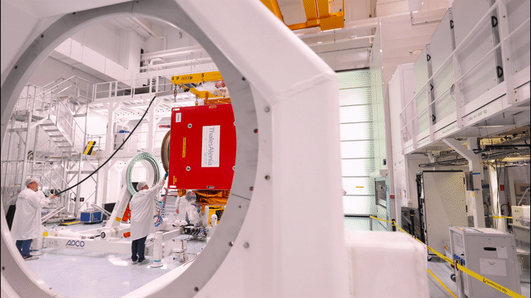
The Copernicus Sentinel-1C satellite is currently in Cannes undergoing a series of demanding tests in preparation for launch in 2023. The third member of the Sentinel-1 radar family, part of Europe’s Copernicus programme, will continue the critical task of delivering key radar imagery of Earth’s surface for a wide range of services and scientific applications.
Aktualizace dat v mapových aplikacích
25.10.2022 8:24 Jihočeský krajData katastru nemovitostí (DKM, KMD, KM-D a ÚKM) byla v mapových aplikacích a výdejním moduli aktualizována k 1.10.2022.
Nearabl Inc. adopts the Bentley iTwin platform to expand infrastructure deployments
24.10.2022 22:52 Bentley SystemsOctober 24, 2022 | Press Announcement Read More
The post Nearabl Inc. adopts the Bentley iTwin platform to expand infrastructure deployments appeared first on Bentley Systems | Infrastructure Engineering Software Company.Guidance for Regulators on using openBIM
24.10.2022 20:00 buildingSMART.orgGuidance for Regulators on using openBIM Activity Proposal is unanimously endorsed. The SC feedback and results for the Regulatory Information Requirements Activity Proposal can be viewed using the following link.…
The post Guidance for Regulators on using openBIM appeared first on buildingSMART International.
registrační formulář do VR
24.10.2022 14:09 ČÚZK - předpisy a opatření Pro registraci subjektů (právnických i fyzických), které se považují za vlastníky, správce a provozovatele dopravní a technické infrastruktury byl do záložky Verifikační registr umístěn odkaz na registrační formulář.20221024_Vrchní referent / rada personálního oddělení
24.10.2022 13:55 ČÚZK - předpisy a opatření Katastrální úřad pro Středočeský kraj Vyhlášení výběrového řízení: Vrchní referent / rada personálního oddělení Katastrálního úřadu V části "Úřední deska", v sekci "Oznámení a jiná úřední sdělení" bylo vystaveno "Oznámení o vyhlášení výběrového řízení na obsazení služebního místa Vrchní referent / rada personálního oddělení"20221024_Vrchní referent / rada personálního oddělení
24.10.2022 13:55 ČÚZK /Urady/Katastralni-urady/Katastralni-urady/Katastralni-urad-pro-Stredocesky-kraj/O-uradu/Aktuality/20210922_Odborny-referent-oddeleni-aktualizace-(1)Boosting Earth science
24.10.2022 13:47 ESA Observing the Earth
With science at the core of the Earth Observation FutureEO programme, ESA has opened a new scientific facility, the Science Hub, which offers new opportunities for collaborative research to further boost the Agency’s and its Member States scientific output.
odborný referent – poskytování informací KN a PK, poskytování podkladů, nahlížení do KN
24.10.2022 12:54 ČÚZK - předpisy a opatření Katastrální úřad pro Olomoucký kraj Katastrální pracoviště Prostějovvypisuje výběrové řízení na místo
odborný referent – poskytování informací KN a PK, poskytování podkladů, nahlížení do KN
odborný referent – poskytování informací KN a PK, poskytování podkladů, nahlížení do KN
24.10.2022 12:54 ČÚZK - volná místa Katastrální úřad pro Olomoucký kraj Katastrální pracoviště Prostějov vypisuje výběrové řízení na místo odborný referent – poskytování informací KN a PK, poskytování podkladů, nahlížení do KNodborný referent/vrchní referent – návrh zápisu v katastru
24.10.2022 12:51 ČÚZK - volná místa Katastrální úřad pro Olomoucký kraj Katastrální pracoviště Šumperk vypisuje výběrové řízení na místo odborný referent/vrchní referent – návrh zápisu v katastruodborný referent/vrchní referent – návrh zápisu v katastru
24.10.2022 12:51 ČÚZK - předpisy a opatření Katastrální úřad pro Olomoucký kraj Katastrální pracoviště Šumperkvypisuje výběrové řízení na místo
odborný referent/vrchní referent – návrh zápisu v katastru
Showcase Geospatial Innovations in Geo Smart 2022
24.10.2022 10:13 Satlab Geosolutions SatLab will be exhibited at booth No.63Showcase Geospatial Innovations in Geo Smart 2022
24.10.2022 10:13 Satlab GeosolutionsSatLab will be exhibited at booth No.63
The post Showcase Geospatial Innovations in Geo Smart 2022 appeared first on Global Satellite Positioning Solutions | SatLab Geosolutions AB.
Výpadek elektrické energie dne 26.10.2022
24.10.2022 10:05 ČÚZK - předpisy a opatření Katastrální úřad pro Středočeský kraj - Katastrální pracoviště Beroun zveřejnil novou aktualitu: Dovolujeme si upozornit, že dne 26.10.2022 mezi 07:30 a 13:00 je na KP Beroun hlášen plánovaný výpadek elektrické energie. Katastrální pracoviště bude v tuto dobu otevřeno pouze v nouzovém režimu, podatelna bude písemnosti pouze přebírat, výpisy budou přijímat pouze objednávky, nebude možná platba platební kartou, nepůjdou telefony a samozřejmě ani žádné osvětlení.Omlouváme se za komplikace
Výpadek elektrické energie dne 26.10.2022
24.10.2022 10:05 ČÚZK /Urady/Katastralni-urady/Katastralni-urady/Katastralni-urad-pro-Stredocesky-kraj/Katastralni-pracoviste/KP-Beroun/O-uradu/Aktuality/Vypadek-elektricke-energie-dne-26-10-2022The scary sound of Earth’s magnetic field
24.10.2022 8:00 ESA Observing the Earth
Despite being essential to life on Earth, the magnetic field isn’t something we can actually see in itself, or ever hear. But, remarkably, scientists at the Technical University of Denmark have taken magnetic signals measured by ESA’s Swarm satellite mission and converted them into sound – and for something that protects us, the result is pretty scary.
20221024 - volné místo - Ředitel/ka KP Ústí nad Labem na Katastrálním úřadu pro Ústecký kraj
24.10.2022 7:38 ČÚZK - předpisy a opatření Katastrální úřad pro Ústecký kraj - Katastrální pracoviště Ústí nad Labem zveřejnil novou aktualitu: Nabídka volného služebního místa představeného - Ředitel / ředitelka Katastrálního pracoviště Ústí nad Labem na Katastrálním úřadu pro Ústecký kraj20221024 - volné místo - Ředitel/ka KP Ústí nad Labem na Katastrálním úřadu pro Ústecký kraj
24.10.2022 7:38 ČÚZK /Urady/Katastralni-urady/Katastralni-urady/Katastralni-urad-pro-Ustecky-kraj/Katastralni-pracoviste/KP-Usti-nad-Labem/O-uradu/Aktuality/20221024-volne-misto-Reditel-ka-KP-Usti-nad-La20221024 - volné místo - Ředitel/ka KP Ústí nad Labem na Katastrálním úřadu pro Ústecký kraj
24.10.2022 7:37 ČÚZK /Urady/Katastralni-urady/Katastralni-urady/Katastralni-urad-pro-Ustecky-kraj/O-uradu/Aktuality/20221024-volne-misto-Reditel-ka-KP-Usti-nad-La20221024 - volné místo - Ředitel/ka KP Ústí nad Labem na Katastrálním úřadu pro Ústecký kraj
24.10.2022 7:37 ČÚZK - předpisy a opatření Katastrální úřad pro Ústecký kraj - Katastrální pracoviště Ústí nad Labem zveřejnil novou aktualitu: Nabídka volného služebního místa představeného - Ředitel / ředitelka Katastrálního pracoviště Ústí nad Labem na Katastrálním úřadu pro Ústecký krajŘeditel / ředitelka Katastrálního pracoviště Ústí nad Labem na Katastrálním úřadu pro Ústecký kraj
24.10.2022 7:35 ČÚZK /Urady/Katastralni-urady/Katastralni-urady/Katastralni-urad-pro-Ustecky-kraj/Uredni-deska/Oznameni-a-jina-uredni-sdeleni/Volna-mista/DMS/Reditel-reditelka-Katastralniho-pracoviste-UstiŘeditel / ředitelka Katastrálního pracoviště Ústí nad Labem na Katastrálním úřadu pro Ústecký kraj
24.10.2022 7:35 ČÚZK - volná místa Katastrální úřad pro Ústecký kraj Katastrální pracoviště Ústí nad Labem vypisuje výběrové řízení na místo Ředitel / ředitelka Katastrálního pracoviště Ústí nad Labem na Katastrálním úřadu pro Ústecký krajŘeditel / ředitelka Katastrálního pracoviště Ústí nad Labem na Katastrálním úřadu pro Ústecký kraj
24.10.2022 7:35 ČÚZK - předpisy a opatření Katastrální úřad pro Ústecký kraj Katastrální pracoviště Ústí nad Labemvypisuje výběrové řízení na místo
Ředitel / ředitelka Katastrálního pracoviště Ústí nad Labem na Katastrálním úřadu pro Ústecký kraj