


![]()

zprávy
zdroje zpráv:20221024 - volné místo - Ředitel/ka KP Ústí nad Labem na Katastrálním úřadu pro Ústecký kraj
24.10.2022 7:38 ČÚZK /Urady/Katastralni-urady/Katastralni-urady/Katastralni-urad-pro-Ustecky-kraj/Katastralni-pracoviste/KP-Usti-nad-Labem/O-uradu/Aktuality/20221024-volne-misto-Reditel-ka-KP-Usti-nad-La20221024 - volné místo - Ředitel/ka KP Ústí nad Labem na Katastrálním úřadu pro Ústecký kraj
24.10.2022 7:37 ČÚZK /Urady/Katastralni-urady/Katastralni-urady/Katastralni-urad-pro-Ustecky-kraj/O-uradu/Aktuality/20221024-volne-misto-Reditel-ka-KP-Usti-nad-La20221024 - volné místo - Ředitel/ka KP Ústí nad Labem na Katastrálním úřadu pro Ústecký kraj
24.10.2022 7:37 ČÚZK - předpisy a opatření Katastrální úřad pro Ústecký kraj - Katastrální pracoviště Ústí nad Labem zveřejnil novou aktualitu: Nabídka volného služebního místa představeného - Ředitel / ředitelka Katastrálního pracoviště Ústí nad Labem na Katastrálním úřadu pro Ústecký krajŘeditel / ředitelka Katastrálního pracoviště Ústí nad Labem na Katastrálním úřadu pro Ústecký kraj
24.10.2022 7:35 ČÚZK /Urady/Katastralni-urady/Katastralni-urady/Katastralni-urad-pro-Ustecky-kraj/Uredni-deska/Oznameni-a-jina-uredni-sdeleni/Volna-mista/DMS/Reditel-reditelka-Katastralniho-pracoviste-UstiŘeditel / ředitelka Katastrálního pracoviště Ústí nad Labem na Katastrálním úřadu pro Ústecký kraj
24.10.2022 7:35 ČÚZK - volná místa Katastrální úřad pro Ústecký kraj Katastrální pracoviště Ústí nad Labem vypisuje výběrové řízení na místo Ředitel / ředitelka Katastrálního pracoviště Ústí nad Labem na Katastrálním úřadu pro Ústecký krajŘeditel / ředitelka Katastrálního pracoviště Ústí nad Labem na Katastrálním úřadu pro Ústecký kraj
24.10.2022 7:35 ČÚZK - předpisy a opatření Katastrální úřad pro Ústecký kraj Katastrální pracoviště Ústí nad Labemvypisuje výběrové řízení na místo
Ředitel / ředitelka Katastrálního pracoviště Ústí nad Labem na Katastrálním úřadu pro Ústecký kraj
20221019 - volné místo - Rada/odb.rada v OMaK kanceláře ředitele KÚ na Katastrálním úřadu pro ÚK
24.10.2022 7:19 ČÚZK /Urady/Katastralni-urady/Katastralni-urady/Katastralni-urad-pro-Ustecky-kraj/O-uradu/Aktuality/20221019-volne-misto-Rada-odb-rada-v-OMaK-kanc20221019 - volné místo - Rada/odb.rada v OMaK kanceláře ředitele KÚ na Katastrálním úřadu pro ÚK
24.10.2022 7:19 ČÚZK - předpisy a opatření Katastrální úřad pro Ústecký kraj zveřejnil novou aktualitu: Nabídka volného místa - Rada / odborný rada v oddělení metodiky a kontroly kanceláře ředitele katastrálního úřadu na Katastrálním úřadu pro Ústecký kraj20221024 - volné místo - Rada/odb.rada v OMaK kanceláře ředitele KÚ na Katastrálním úřadu pro ÚK
24.10.2022 7:19 ČÚZK /Urady/Katastralni-urady/Katastralni-urady/Katastralni-urad-pro-Ustecky-kraj/O-uradu/Aktuality/20221019-volne-misto-Rada-odb-rada-v-OMaK-kanc20221024 - volné místo - Rada/odb.rada v OMaK kanceláře ředitele KÚ na Katastrálním úřadu pro ÚK
24.10.2022 7:19 ČÚZK - předpisy a opatření Katastrální úřad pro Ústecký kraj zveřejnil novou aktualitu: Nabídka volného místa - Rada / odborný rada v oddělení metodiky a kontroly kanceláře ředitele katastrálního úřadu na Katastrálním úřadu pro Ústecký krajRada / odborný rada v oddělení metodiky a kontroly kanceláře ředitele katastrálního úřadu na Katastr
24.10.2022 7:16 ČÚZK - volná místa Katastrální úřad pro Ústecký kraj kancelář ředitele vypisuje výběrové řízení na místo Rada / odborný rada v oddělení metodiky a kontroly kanceláře ředitele katastrálního úřadu na KatastrRada / odborný rada v oddělení metodiky a kontroly kanceláře ředitele katastrálního úřadu na Katastr
24.10.2022 7:16 ČÚZK - předpisy a opatření Katastrální úřad pro Ústecký kraj kancelář ředitelevypisuje výběrové řízení na místo
Rada / odborný rada v oddělení metodiky a kontroly kanceláře ředitele katastrálního úřadu na Katastrálním úřadu pro Ústecký kraj
Rada / odborný rada v oddělení metodiky a kontroly kanceláře ředitele katastrálního úřadu na Katastr
24.10.2022 7:16 ČÚZK /Urady/Katastralni-urady/Katastralni-urady/Katastralni-urad-pro-Ustecky-kraj/Uredni-deska/Oznameni-a-jina-uredni-sdeleni/Volna-mista/DMS/Rada-odborny-rada-v-oddeleni-metodiky-a-kontrolyRoadShow 2022
22.10.2022 10:00 3gon 3gon Positioning s.r.o. Vás zve na letošní ročník RoadShow 2022, který se bude konat v termínech od 11 do 16.11.2022RoadShow 2022
22.10.2022 10:00 3gon 3gon Positioning s.r.o. Vás zve na letošní ročník RoadShow 2022, který se bude konat v týdnu od 11 do 16.11.20223GONTOUR 2022
22.10.2022 10:00 3gon 3gon Positioning s.r.o. Vás zve na letošní ročník RoadShow 2022, který se bude konat v termínech od 11 do 16.11.2022How Bentley Systems’ 3DFT could conquer the infrastructure metaverse
21.10.2022 22:31 Bentley SystemsPublication October 21, 2022 | Press Coverage Read Article
The post How Bentley Systems’ 3DFT could conquer the infrastructure metaverse appeared first on Bentley Systems | Infrastructure Engineering Software Company.Will megaprojects bring Australia’s construction industry to the next level?
21.10.2022 22:29 Bentley SystemsPublication October 21, 2022 | Press Coverage Read Article
The post Will megaprojects bring Australia’s construction industry to the next level? appeared first on Bentley Systems | Infrastructure Engineering Software Company.The Cost-Saving Benefits of Digital Twin: Bentley’s Cecilia Correia joins WF&M Conversations
21.10.2022 22:24 Bentley SystemsPublicationOctober 21, 2022 | Press Coverage Read Article
The post The Cost-Saving Benefits of Digital Twin: Bentley’s Cecilia Correia joins WF&M Conversations appeared first on Bentley Systems | Infrastructure Engineering Software Company.Paul King on digital building tech and where it’s taking us
21.10.2022 22:21 Bentley SystemsPublicationOctober 21, 2022 | Press Coverage Read Article
The post Paul King on digital building tech and where it’s taking us appeared first on Bentley Systems | Infrastructure Engineering Software Company.Paul King on digital building tech and where it’s taking us
21.10.2022 22:21 Bentley SystemsPublication October 21, 2022 | Press Coverage Read More
The post Paul King on digital building tech and where it’s taking us appeared first on Bentley Systems | Infrastructure Engineering Software Company.” … a match made for future-proofing Infrastructure …” Nicholas Cumins, COO Bentley Systems
21.10.2022 22:04 Bentley SystemsPublication October 21, 2022 | Press Coverage Watch Now
The post ” … a match made for future-proofing Infrastructure …” Nicholas Cumins, COO Bentley Systems appeared first on Bentley Systems | Infrastructure Engineering Software Company.Paul King on digital building tech and where it’s taking us
21.10.2022 21:30 Bentley SystemsPublication October 21, 2022 | Press Coverage Read Article
The post Paul King on digital building tech and where it’s taking us appeared first on Bentley Systems | Infrastructure Engineering Software Company.The Cost-Saving Benefits of Digital Twin: Bentley’s Cecilia Correia joins WF&M Conversations
21.10.2022 21:15 Bentley SystemsPublicationOctober 12, 2022 | Press Coverage Read Article
The post The Cost-Saving Benefits of Digital Twin: Bentley’s Cecilia Correia joins WF&M Conversations appeared first on Bentley Systems | Infrastructure Engineering Software Company.We want to hear from end users like you: the EGNOS and Galileo Survey is now open
21.10.2022 17:26 European GNSS Agency
Our mission is to link space to user needs, but to do that, we need to hear from you. The EUSPA Galileo and EGNOS User Satisfaction Survey is your chance to tell us what you think about the two programmes and share your thoughts on how to make the services they provide even better.
“The survey collects a range of valuable information from users like you,” says EUSPA Executive Director Rodrigo da Costa. “From your perception of and expectations for Galileo and EGNOS to suggestions for improvements, this is a unique opportunity to share your thoughts and ideas.”
Addressing specific market segments
The survey is for the first time combining EGNOS and Galileo with harmonised structures for users who want to assess both services.
It addresses a specific market segment, including aviation and drones, maritime and inland waterways, rail, road and automotive, consumer solutions, agriculture, infrastructure – and more. Start by selecting the segment (or segments) most important to you or your company, then answer a few simple questions – that’s all there is to it.
The EGNOS part of the survey also covers all EGNOS services, including the Open Service, Safety of Life Service and EGNOS Data Access Service (EDAS). While the Galileo User part of the survey includes questions about improving the services provided by the European GNSS Service Centre (GSC), the EGNOS part asks about the EGNOS service provider’s management of user's interfaces.
Ready to get started? You can take the User Satisfaction Survey here.
Make a BIG difference in a short time
Although the survey will only take a few minutes of your time, your input will make a big difference in the evolution of the EU Space Programme. “EUSPA looks forward to receiving your feedback, which we will use to improve Galileo and EGNOS to better meet your evolving needs,” adds da Costa.
The survey results will be compiled into reports and made available to the public next year. The results of last year’s surveys can be found in the 2021 Galileo User Satisfaction Survey Report and EGNOS User Satisfaction Report.
Media note: This feature can be republished without charge provided the European Union Agency for the Space Programme (EUSPA) is acknowledged as the source at the top or the bottom of the story. You must request permission before you use any of the photographs on the site. If you republish, we would be grateful if you could link back to the EUSPA website (http://www.euspa.europa.eu).
The buildingSMART openBIM Awards Program 2022 – Winners Announced
21.10.2022 16:28 buildingSMART.orgLondon, (October 21, 2022) buildingSMART International is delighted to announce the full list of winners from the Awards Program 2022. All finalists presented their projects during the buildingSMART International Standards Summit…
The post The buildingSMART openBIM Awards Program 2022 – Winners Announced appeared first on buildingSMART International.
Nová verze TurboCAD Deluxe!
21.10.2022 16:12 ŠPINAR - softwareNová verze TurboCAD Deluxe 28 CZ již v naší nabídce. V akční ceně do 30. 10. 2022,
The post Nová verze TurboCAD Deluxe! appeared first on ŠPINAR – software.
Nová verze TurboCAD Deluxe!
21.10.2022 16:12 ŠPINAR - software Nová verze TurboCAD Deluxe 28 CZ již v naší nabídce. V akční ceně do 30. 10. 2022,Odborný referent v oddělení obnovy katastrálního operátu č.3 na Technické sekci
21.10.2022 10:07 ČÚZK - předpisy a opatření Katastrální úřad pro Jihomoravský kraj technická sekcevypisuje výběrové řízení na místo
Odborný referent v oddělení obnovy katastrálního operátu č.3 na Technické sekci
Odborný referent v oddělení obnovy katastrálního operátu č.3 na Technické sekci
21.10.2022 10:07 ČÚZK - volná místa Katastrální úřad pro Jihomoravský kraj technická sekce vypisuje výběrové řízení na místo Odborný referent v oddělení obnovy katastrálního operátu č.3 na Technické sekciOdborný referent v oddělení obnovy katastrálního operátu č.3 na Technické sekci
21.10.2022 10:07 ČÚZK /Urady/Katastralni-urady/Katastralni-urady/Katastralni-urad-pro-Jihomoravsky-kraj/Uredni-deska/Oznameni-a-jina-uredni-sdeleni/Volna-mista/DMS/Odborny-referent-v-oddeleni-obnovy-katastralni-(1)Earth from Space: Inhambane Bay, Mozambique
21.10.2022 10:00 ESA Observing the Earth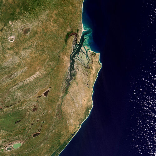
Inhambane Bay, in southeast Mozambique, is featured in this true-colour image captured by the Copernicus Sentinel-2 mission.
Odborný referent v oddělení obnovy katastrálního operátu č.1 na Technicé sekci
21.10.2022 9:53 ČÚZK - volná místa Katastrální úřad pro Jihomoravský kraj technická sekce vypisuje výběrové řízení na místo Odborný referent v oddělení obnovy katastrálního operátu č.1 na Technicé sekciOdborný referent v oddělení obnovy katastrálního operátu č.1 na Technicé sekci
21.10.2022 9:53 ČÚZK - předpisy a opatření Katastrální úřad pro Jihomoravský kraj technická sekcevypisuje výběrové řízení na místo
Odborný referent v oddělení obnovy katastrálního operátu č.1 na Technicé sekci
Odborný referent v oddělení obnovy katastrálního operátu č.1 na Technicé sekci
21.10.2022 9:53 ČÚZK /Urady/Katastralni-urady/Katastralni-urady/Katastralni-urad-pro-Jihomoravsky-kraj/Uredni-deska/Oznameni-a-jina-uredni-sdeleni/Volna-mista/DMS/Odborny-referent-v-oddeleni-obnovy-katastralniho-oSIEMENS CELEBRATES 175 YEARS AND LOOKS FORWARD TO THE INDUSTRIAL METAVERSE
21.10.2022 8:10 Bentley Systems175 Years of Siemens Technology and the Industrial Metaverse
The post SIEMENS CELEBRATES 175 YEARS AND LOOKS FORWARD TO THE INDUSTRIAL METAVERSE appeared first on Bentley Systems | Infrastructure Engineering Software Company.vozidlo FORD FOCUS, typ DA3, RZ 3B1 3786
21.10.2022 6:13 ČÚZK /Urady/Katastralni-urady/Katastralni-urady/Katastralni-urad-pro-Jihomoravsky-kraj/Nabidky-majetku/vozidlo-FORD-FOCUS,-typ-DA3,-RZ-3B1-3786vozidlo FORD FOCUS, typ DA3, RZ 3B1 3786
21.10.2022 6:13 ČÚZK - předpisy a opatřeníKatastrální úřad pro Jihomoravský kraj nabízí nepotřebný majetek k odkupu. Jedná se o
vozidlo FORD FOCUS, typ DA3, RZ 3B1 3786
rada / odborný rada v oddělení právních vztahů k nemovitostem Katastrálního pracoviště Ústí nad Orli
20.10.2022 13:37 ČÚZK - volná místa Katastrální úřad pro Pardubický kraj Katastrální pracoviště Ústí nad Orlicí vypisuje výběrové řízení na místo rada / odborný rada v oddělení právních vztahů k nemovitostem Katastrálního pracoviště Ústí nad Orlirada / odborný rada v oddělení právních vztahů k nemovitostem Katastrálního pracoviště Ústí nad Orli
20.10.2022 13:37 ČÚZK - předpisy a opatření Katastrální úřad pro Pardubický kraj Katastrální pracoviště Ústí nad Orlicívypisuje výběrové řízení na místo
Oznámení o vyhlášení výběrového řízení na služební místo - rada / odborný rada v oddělení právních vztahů k nemovitostem Katastrálního pracoviště Ústí nad Orlicí
rada / odborný rada v oddělení právních vztahů k nemovitostem Katastrálního pracoviště Ústí nad Orli
20.10.2022 13:37 ČÚZK /Urady/Katastralni-urady/Katastralni-urady/Katastralni-urad-pro-Pardubicky-kraj/Uredni-deska/Oznameni-a-jina-uredni-sdeleni/Volna-mista/DMS/rada-odborny-rada-v-oddeleni-pravnich-vztahu-k-nMapping planet Earth for better positioning: ESA’s GENESIS mission
20.10.2022 12:43 ESA Navigation
ESA’s Navigation Directorate is planning a new satellite whose results will enable the generation of an updated global model of Earth – the International Terrestrial Reference Frame, employed for everything from land surveying to measuring sea level rise – with an accuracy down to 1 mm, while tracking ground motion of just 0.1 mm per year. This improvement, at a stroke, will have a major impact in multiple navigation and Earth science applications, including enhancing the precision of the Galileo navigation system. This mission, called GENESIS, is being proposed to ESA’s Council Meeting at Ministerial Level next month.
Mapping planet Earth for better positioning: ESA’s GENESIS mission
20.10.2022 12:43 ESA Navigation
ESA’s Navigation Directorate is planning a new satellite whose results will enable the generation of an updated global model of Earth – the International Terrestrial Reference Frame, employed for everything from land surveying to measuring sea level rise – with an accuracy down to 1 mm, while tracking ground motion of just 0.1 mm per year. This improvement, at a stroke, will have a major impact in multiple navigation and Earth science applications, including enhancing the precision of the Galileo navigation system. This mission, called GENESIS, is being proposed to ESA’s Council Meeting at Ministerial Level next month.
Zemřel RNDr. Jiří Novotný (1931-2022) [Knihovna geografie, byTopic]
20.10.2022 0:00 Katedra aplikované geoinformatiky a kartografie Přf UK Na počátku října zemřel ve věku 91 let RNDr. Jiří Novotný, rodák z Klatov, absolvent oboru fyzické a regionální geografie Přírodovědecké fakulty University Karlovy. Po absolvování nastoupil do Kartografického a reprodukčního ústavu, dnešní Kartografie Praha, a. s. Byl odpovědným redaktorem všeobecně zeměpisných map. K jeho základním dílům patřil unikátní soubor Poznáváme svět a kapesní atlasy světa v české i cizojazyčných mutacích. Jako specialista se věnoval výchově mladých redaktorů. Od roku 1984 byl členem České geografické společnosti. Dlouhodobě podporoval dary Knihovnu geografie PřF UK.Zemřel RNDr. Jiří Novotný (1931-2022) [Knihovna geografie, byTopic]
20.10.2022 0:00 Katedra aplikované geoinformatiky a kartografie Přf UK Na počátku října zemřel ve věku 91 let RNDr. Jiří Novotný, rodák z Klatov, absolvent oboru fyzické a regionální geografie Přírodovědecké fakulty University Karlovy. Po absolvování nastoupil do kartografického a reprodukčního ústavu, dnešní Kartografie Praha, a. s. Byl odpovědným redaktorem všeobecně zeměpisných map. K jeho základním dílům patřil unikátní soubor Poznáváme svět a kapesní atlasy světa v české i cizojazyčných mutacích. Jako specialista se věnoval výchově mladých redaktorů. Od roku 1984 byl členem České geografické společnosti. Dlouhodobě podporoval dary Knihovnu geografie PřF UK.20221019 - volné místo - Referent v OAaD KP Ústí n.L. na Katastrálním úřadu pro Ústecký kraj
19.10.2022 13:06 ČÚZK /Urady/Katastralni-urady/Katastralni-urady/Katastralni-urad-pro-Ustecky-kraj/Katastralni-pracoviste/KP-Usti-nad-Labem/O-uradu/Aktuality/20221019-volne-misto-Referent-v-OAaD-KP-Usti-n20221019 - volné místo - Referent v OAaD KP Ústí n.L. na Katastrálním úřadu pro Ústecký kraj
19.10.2022 13:06 ČÚZK - předpisy a opatření Katastrální úřad pro Ústecký kraj - Katastrální pracoviště Ústí nad Labem zveřejnil novou aktualitu: Nabídka volného místa - Referent v oddělení aktualizace a dokumentace katastru nemovitostí Katastrálního pracoviště Ústí nad Labem na Katastrálním úřadu pro Ústecký kraj20221019 - volné místo - Referent v OAaD KP Ústí n.L. na Katastrálním úřadu pro Ústecký kraj
19.10.2022 13:06 ČÚZK - předpisy a opatření Katastrální úřad pro Ústecký kraj - Katastrální pracoviště Ústí nad Labem zveřejnil novou aktualitu: Nabídka volného místa - Referent v oddělení aktualizace a dokumentace katastru nemovitostí Katastrálního pracoviště Ústí nad Labem na Katastrálním úřadu pro Ústecký kraj20221019 - volné místo - Referent v OAaD KP Ústí n.L. na Katastrálním úřadu pro Ústecký kraj
19.10.2022 13:06 ČÚZK /Urady/Katastralni-urady/Katastralni-urady/Katastralni-urad-pro-Ustecky-kraj/O-uradu/Aktuality/20221019-volne-misto-Referent-v-OAaD-KP-Usti-nReferent v oddělení aktualizace a dokumentace katastru nemovitostí Katastrálního pracoviště Ústí nad
19.10.2022 13:02 ČÚZK - předpisy a opatření Katastrální úřad pro Ústecký kraj Katastrální pracoviště Ústí nad Labemvypisuje výběrové řízení na místo
Referent v oddělení aktualizace a dokumentace katastru nemovitostí Katastrálního pracoviště Ústí nad Labem na Katastrálním úřadu pro Ústecký kraj
Referent v oddělení aktualizace a dokumentace katastru nemovitostí Katastrálního pracoviště Ústí nad
19.10.2022 13:02 ČÚZK - volná místa Katastrální úřad pro Ústecký kraj Katastrální pracoviště Ústí nad Labem vypisuje výběrové řízení na místo Referent v oddělení aktualizace a dokumentace katastru nemovitostí Katastrálního pracoviště Ústí nadReferent v oddělení aktualizace a dokumentace katastru nemovitostí Katastrálního pracoviště Ústí nad
19.10.2022 13:02 ČÚZK /Urady/Katastralni-urady/Katastralni-urady/Katastralni-urad-pro-Ustecky-kraj/Volna-mista/DMS/Referent-v-oddeleni-aktualizace-a-dokumentace-kataKrátka správa č. 48/2022
19.10.2022 7:57 Komora geodetů a kartografů SRThe post Krátka správa č. 48/2022 appeared first on Komora geodetov a kartografov.
Krátka správa č. 47/2022
19.10.2022 7:55 Komora geodetů a kartografů SRThe post Krátka správa č. 47/2022 appeared first on Komora geodetov a kartografov.
Krátka správa č. 46/2022
19.10.2022 7:54 Komora geodetů a kartografů SRThe post Krátka správa č. 46/2022 appeared first on Komora geodetov a kartografov.
Bentley Systems to Announce Third Quarter 2022 Operating Results
18.10.2022 20:35 Bentley SystemsOctober 18, 2022 | Press Announcement Read More
The post Bentley Systems to Announce Third Quarter 2022 Operating Results appeared first on Bentley Systems | Infrastructure Engineering Software Company.KARTOVÝROČÍ 2022 & Mezníky digitální kartografie
18.10.2022 19:58 Česká kartografická společnost Česká kartografická společnost zve své členy i všechny zájemce o mapy a kartografii na seminář KARTOVÝROČÍ 2022 & Mezníky digitální kartografie, který se uskuteční ve čtvrtek 10. listopadu 2022 v prostorách Fakulty stavební ČVUT v Praze, Thákurova 7, Praha 6 (metro Dejvická), místnost C223. Zajímavý program je připraven na celé odpoledne od 13:30 do 17 hodin. […]KARTOVÝROČÍ 2022 & Mezníky digitální kartografie
18.10.2022 19:58 Česká kartografická společnostČeská kartografická společnost zve své členy i všechny zájemce o mapy a kartografii na seminář KARTOVÝROČÍ 2022 & Mezníky digitální kartografie, který se uskuteční ve čtvrtek 10. listopadu 2022 v prostorách Fakulty stavební ČVUT v Praze, Thákurova 7, Praha 6 (metro Dejvická), místnost C223. Zajímavý program je připraven na celé odpoledne od 13:30 do 17 hodin. […]
The post KARTOVÝROČÍ 2022 & Mezníky digitální kartografie first appeared on Česká kartografická společnost.
HLEDÁME DO TÝMU: Obchodní asistentka v geoinformatice
18.10.2022 17:45 TopGis Máš ráda komunikaci se zákazníky? Máš týmového ducha? Baví Tě pracovat s „papírovou“ agendou? Baví Tě spolupracovat s kolegy a společným úsilím dosahovat cíle? Umíš najít a navrhnout jiné řešení? Pokud ano, tak hledáme právě Tebe. Požadujeme: Očekáváme: Nabízíme: Zaujala Vás naše nabídka? Pokud Vás tato pozice zaujala, zašlete nám Váš CV na e-mail: kariera@topgis.cz V případě, žeVýběrové řízení na pozici vrchní referent / rada v oddělení obnovy katastrálního operátu technického
18.10.2022 13:38 ČÚZK - předpisy a opatření Katastrální úřad pro Královéhradecký krajvypisuje výběrové řízení na místo
Výběrové řízení na pozici vrchní referent / rada v oddělení obnovy katastrálního operátu technického útvaru
Výběrové řízení na pozici vrchní referent / rada v oddělení obnovy katastrálního operátu technického
18.10.2022 13:38 ČÚZK - volná místa Katastrální úřad pro Královéhradecký kraj vypisuje výběrové řízení na místo Výběrové řízení na pozici vrchní referent / rada v oddělení obnovy katastrálního operátu technickéhovýběrové řízení na KP Pelhřimov
18.10.2022 12:56 ČÚZK - předpisy a opatření Katastrální úřad pro Vysočinu - Katastrální pracoviště Pelhřimov zveřejnil novou aktualitu: Oznámení o vyhlášení výběrového řízení na služební místo odborný referent/vrchní referent v oddělení právní vztahy k nemovitostem Katastrálního pracoviště Pelhřimov na Katastrálním úřadu pro Vysočinu.odborný referent-právní KP Pelhřimov
18.10.2022 12:06 ČÚZK /Urady/Katastralni-urady/Katastralni-urady/Katastralni-urad-pro-Vysocinu/Uredni-deska/Oznameni-a-jina-uredni-sdeleni/Volna-mista/DMS/odborny-referent-pravni-KP-Pelhrimovodborný referent-právní KP Pelhřimov
18.10.2022 12:06 ČÚZK - předpisy a opatření Katastrální úřad pro Vysočinu Katastrální pracoviště Pelhřimovvypisuje výběrové řízení na místo
odborný referent-právní KP Pelhřimov
odborný referent-právní KP Pelhřimov
18.10.2022 12:06 ČÚZK - volná místa Katastrální úřad pro Vysočinu Katastrální pracoviště Pelhřimov vypisuje výběrové řízení na místo odborný referent-právní KP PelhřimovEurope’s all-new weather satellite arrives at launch site
18.10.2022 10:30 ESA Observing the Earth
After a two-week voyage across the Atlantic Ocean, the ship transporting the first Meteosat Third Generation satellite docked at Pariacabo in French Guiana and the precious cargo unloaded. Now safe and sound in one of the spaceport’s cleanrooms, satellite engineers will ready it for liftoff on an Ariane 5 rocket in December. Once in geostationary orbit, this new satellite, which carries two new extremely sensitive instruments, promises to further bolster Europe's leadership in weather forecasting.
odborný referent/vrchní referent – obnova katastrálního operátu
18.10.2022 7:20 ČÚZK - volná místa Katastrální úřad pro Olomoucký kraj Katastrální pracoviště Prostějov vypisuje výběrové řízení na místo odborný referent/vrchní referent – obnova katastrálního operátuodborný referent/vrchní referent – obnova katastrálního operátu
18.10.2022 7:20 ČÚZK - předpisy a opatření Katastrální úřad pro Olomoucký kraj Katastrální pracoviště Prostějovvypisuje výběrové řízení na místo
odborný referent/vrchní referent – obnova katastrálního operátu
Will megaprojects bring Australia’s construction industry to the next level?
17.10.2022 21:45 Bentley SystemsPublication October 17, 2022 | Press Coverage Read Article
The post Will megaprojects bring Australia’s construction industry to the next level? appeared first on Bentley Systems | Infrastructure Engineering Software Company.oborný referent v oddělení aktualizace KN č. 1 na Katastrálním pracovišti Znojmo
17.10.2022 15:08 ČÚZK /Urady/Katastralni-urady/Katastralni-urady/Katastralni-urad-pro-Jihomoravsky-kraj/Uredni-deska/Oznameni-a-jina-uredni-sdeleni/Volna-mista/DMS/oborny-referent-v-oddeleni-aktualizace-KN-c-1-naoborný referent v oddělení aktualizace KN č. 1 na Katastrálním pracovišti Znojmo
17.10.2022 15:08 ČÚZK - předpisy a opatření Katastrální úřad pro Jihomoravský kraj Katastrální pracoviště Znojmovypisuje výběrové řízení na místo
oborný referent v oddělení aktualizace KN č. 1 na Katastrálním pracovišti Znojmo
oborný referent v oddělení aktualizace KN č. 1 na Katastrálním pracovišti Znojmo
17.10.2022 15:08 ČÚZK - volná místa Katastrální úřad pro Jihomoravský kraj Katastrální pracoviště Znojmo vypisuje výběrové řízení na místo oborný referent v oddělení aktualizace KN č. 1 na Katastrálním pracovišti ZnojmoOznámení o vyhlášení výběrového řízení na služební místo odborný/vrchní referent v oddělení aktualiz
17.10.2022 12:41 ČÚZK - předpisy a opatření Katastrální úřad pro Pardubický kraj Katastrální pracoviště Ústí nad Orlicívypisuje výběrové řízení na místo
Oznámení o vyhlášení výběrového řízení na služební místo odborný/vrchní referent v oddělení aktualizace katastru nemovitostí Katastrálního pracoviště Ústí nad Orlicí
Oznámení o vyhlášení výběrového řízení na služební místo odborný/vrchní referent v oddělení aktualiz
17.10.2022 12:41 ČÚZK - volná místa Katastrální úřad pro Pardubický kraj Katastrální pracoviště Ústí nad Orlicí vypisuje výběrové řízení na místo Oznámení o vyhlášení výběrového řízení na služební místo odborný/vrchní referent v oddělení aktualizOznámení o vyhlášení výběrového řízení na služební místo odborný/vrchní referent v oddělení aktualiz
17.10.2022 12:41 ČÚZK /Urady/Katastralni-urady/Katastralni-urady/Katastralni-urad-pro-Pardubicky-kraj/Uredni-deska/Oznameni-a-jina-uredni-sdeleni/Volna-mista/DMS/Oznameni-o-vyhlaseni-vyberoveho-rizeni-na-sluz-(1)EU Space to play a pivotal role in the European Critical Raw Materials Act
17.10.2022 12:23 European GNSS Agency
If oil and gas were once considered the ‘new gold’, then lithium and rare-earth elements (REE) are the new oil and gas.
Whereas oil and gas boomed thanks to the development of the automobile, global trade and the plastics industry, lithium and REE are key to a wide array of high-tech and climate applications, including solar and wind energy, mobile phones, computers and electric vehicles. “We are experiencing a global race for the supply and recycling of critical raw materials,” confirmed Commissioner Breton.
Furthermore, like oil and gas, if the EU does not take strategic steps to shore up its reserves of lithium and REE today , it risks becoming dependent on supply from other countries – a dependency that could impact the green transition .
“Without secure and sustainable access to the necessary raw materials, our ambition to become the first climate neutral continent is at risk… we will not lead the digital decade and we will not be able to develop our defence capabilities,” said European Commission President Ursula von der Leyen during her state of the European Union address.
In an effort to mitigate the EU’s dependence on the extraction, processing and recycling of critical raw materials, a European Critical Raw Materials Act has been announced. The Act aims to build up reserves where supply is at risk by identifying potential strategic projects along the entire supply chain. The strategic raw materials are essential for the EU economic interest.
As said by the European Commission President “Let's make sure the future of industry is made in Europe.”
Not only made in Europe but also supported by European projects and technology – including the EU Space Programme.
The mining sector was an early adopter of augmented GNSS solutions, using it for everything from surveying mining sites to accessing remote areas and enabling the safe operation of heavy machinery. Now, with many mining activities becoming increasingly automated, GNSS has become a key enabler for the management of mining operations.
The raw materials sector also depends on Earth Observation (EO). For example, companies can use hyperspectral imagery at the exploration stage to assess the abundancy of certain metals and minerals. When the mine site is up and running, high-resolution EO data is used to monitor many aspects of operations, including pit slopes and ground motion effects. Even when a mining site closes, Earth Observation plays an important role in environmental monitoring, rehabilitation and waste management.
The synergistic use of EO and GNSS is a golden opportunity for the raw materials sector
While GNSS and Earth Observation are powerful tools in their own right, the raw materials sector stands to benefit the most when these solutions are used in synergy. That’s why the European Commission is supporting such initiatives as the GOLDENEYE project.
The innovative platform proposed by GOLDENEYE, combines remote sensing and positioning technologies to take advantage of Earth Observation and GNSS data, together with data fusion and processing powered by data analytics and machine learning algorithms. The result is an increase in mine productivity and in a company’s ability to monitor and control an operation’s environmental impact.
With the raw materials sector already leveraging the benefits of GNSS and Earth Observation for it is whole life-cycle from exploration to, operations and closure thus boosting efficiency, automation, safety and environmental management of mining operations, EU Space is well-placed to play a pivotal role in ensuring the battery metals independence envisioned by the European Critical Raw Materials Act.
Media note: This feature can be republished without charge provided the European Union Agency for the Space Programme (EUSPA) is acknowledged as the source at the top or the bottom of the story. You must request permission before you use any of the photographs on the site. If you republish, we would be grateful if you could link back to the EUSPA website (http://www.euspa.europa.eu).
ZABAGED® - aktualizace
17.10.2022 8:00 ČÚZK - Geoportál ZABAGED® - aktualizaceZačátkem října 2022 byly zpřístupněny uživatelům zaktualizované sady těchto typů objektů ZABAGED®: definiční body adresních míst, úřady, pošty, zdravotnická zařízení, nemocnice, bunkry a kótované body. Průběžně byly během celého období aktualizovány definiční čáry ulic podle návrhu obcí současně s definičními body náměstí.
Ve 3. čtvrtletí 2022 byla dokončena plošná aktualizace ZABAGED® na celém území mapových listů Základní topografické mapy ČR 1:50 000: 0105-D, 0106-C, 0205-B, 0302-A, 0307-D, 0308-C, 0308-D, 0405-A, 0405-B, 0407-B, 0408-A, 0408-B, 0704-B, 0704-D, 0709-C, 0808-A, 0808-B, 0809-A a dále byla dokončena na vybraných částech území mapových listů Základní topografické mapy ČR 1:50 000: 0307-C.
Ve 3. čtvrtletí 2022 byly v rámci zpřesňování stavebních objektů v ZABAGED® ® (na podkladě existující kresby v ISKN, Ortofota ČR, výstupů z dat leteckého laserového skenování a dalších dostupných zdrojů) aktualizovány budovy a další stavební objekty v okresech: Blansko, Brno-město, Brno-venkov, Frýdek-Místek, Hl. město Praha, Cheb, Jičín, Karviná, Kladno, Kroměříž, Kutná Hora, Náchod, Plzeň-jih, Plzeň-město, Praha-západ, Prostějov, Přerov, Semily, Strakonice, Svitavy, Vsetín, Zlín, Znojmo.
Více informací o stavu aktualizace je uvedeno v tabulce Informace o produktu, v oddíle Aktualizační cyklus - stav aktualizace.
ZABAGED® - aktualizace
17.10.2022 7:00 ČÚZK - Geoportál ZABAGED® - aktualizaceZačátkem října 2022 byly zpřístupněny uživatelům zaktualizované sady těchto typů objektů ZABAGED®: definiční body adresních míst, úřady, pošty, zdravotnická zařízení, nemocnice, bunkry a kótované body. Průběžně byly během celého období aktualizovány definiční čáry ulic podle návrhu obcí současně s definičními body náměstí.
Ve 3. čtvrtletí 2022 byla dokončena plošná aktualizace ZABAGED® na celém území mapových listů Základní topografické mapy ČR 1:50 000: 0105-D, 0106-C, 0205-B, 0302-A, 0307-D, 0308-C, 0308-D, 0405-A, 0405-B, 0407-B, 0408-A, 0408-B, 0704-B, 0704-D, 0709-C, 0808-A, 0808-B, 0809-A a dále byla dokončena na vybraných částech území mapových listů Základní topografické mapy ČR 1:50 000: 0307-C.
Ve 3. čtvrtletí 2022 byly v rámci zpřesňování stavebních objektů v ZABAGED® ® (na podkladě existující kresby v ISKN, Ortofota ČR, výstupů z dat leteckého laserového skenování a dalších dostupných zdrojů) aktualizovány budovy a další stavební objekty v okresech: Blansko, Brno-město, Brno-venkov, Frýdek-Místek, Hl. město Praha, Cheb, Jičín, Karviná, Kladno, Kroměříž, Kutná Hora, Náchod, Plzeň-jih, Plzeň-město, Praha-západ, Prostějov, Přerov, Semily, Strakonice, Svitavy, Vsetín, Zlín, Znojmo.
Více informací o stavu aktualizace je uvedeno v tabulce Informace o produktu, v oddíle Aktualizační cyklus - stav aktualizace.
Reportáž z JOINT CONFERENCE v Plzni
17.10.2022 6:11 GISportal.cz
Po kovidových letech, kdy byly všechny konference virtuální nebo zrušené se postupně vrací doba prezenčních akcí. Jednou z tradičních podzimních konferencí je i „Geomatika v projektech“ v Plzni. Celým názvem JOINT CONFRENCE, která se skládala z 26. ročníku konference Informačních systémů v zemědělství a lesnictví (ISAF), 15. ročníku Geomatiky v projektech a 7. výroční konference asociace Plan4All. […]
The post Reportáž z JOINT CONFERENCE v Plzni appeared first on GISportal.cz.
Nová verze TurboCAD Platinum!
16.10.2022 18:11 ŠPINAR - softwareNová verze TurboCAD Platinum 28 CZ již v naší nabídce. V akční ceně do 23. 10. 2022,
The post Nová verze TurboCAD Platinum! appeared first on ŠPINAR – software.
Nová verze TurboCAD Platinum!
16.10.2022 18:11 ŠPINAR - softwareNová verze TurboCAD Platinum 28 CZ již v naší nabídce. V akční ceně do 23. 10. 2022,
The post Nová verze TurboCAD Platinum! appeared first on ŠPINAR – software.
Nová verze TurboCAD Platinum!
16.10.2022 18:11 ŠPINAR - software Nová verze TurboCAD Platinum 28 CZ již v naší nabídce. V akční ceně do 23. 10. 2022,
Portál ESKN - prevádzková informácia
16.10.2022 9:43
ÚGKK SR
V dňoch 16.10.2022 od 13:30 hod. do 17.10.2022 do 16:00 hod. budú elektronické služby podaní do katastra nehnuteľností na Portáli ESKN nedostupné vzhľadom na realizáciu potrebných technických zmien. Ostatné služby Portálu ESKN - predovšetkým vyhľadávanie údajov a oznámenia o návrhu na vklad - budú dostupné.
#PortálESKN #od:16.10.2022@13:30 #do:17.10.2022@16:00
EUSPA launches the #myEUspace competition 2022
14.10.2022 14:48 European GNSS Agency
Have an idea for a commercial application that leverages the power of the EU Space Programme? Looking for support to turn that idea into a prototype or to take it to market? Then check out the #myEUspace 2022 competition!
The annual competition, which is organised by the EU Agency for the Space Programme (EUSPA) as part of the European Commission’s CASSINI – Space Entrepreneurship Initiative, challenges innovators and entrepreneurs to create game-changing commercial solutions that use data coming from Galileo, Copernicus or both.
“Space data is at the heart of the technological revolution currently sweeping Europe, and this competition is another example of how EUSPA supports innovative entrepreneurs, start-ups and SMEs from across the EU who are leveraging Copernicus and Galileo data, information and services, during the different steps of their evolution cycle,” says EUSPA Executive Director Rodrigo da Costa.
While ideas can range from mobile applications to hardware-based solutions, all must be tied to one of three targeted innovation areas:
• Space My Life: Consumer solutions like mobile applications, wearables (smart watches, smart glasses, fitness trackers, etc.), drones or robotics that address major societal challenges in focus areas such as health, citizen safety and security, gaming and entertainment, sports and fitness, and tourism.
• Our Green Planet: Innovative solutions addressing environmental challenges and sustainable life and that contribute to the implementation of the European Green Deal, as well as solutions that aid the green transformation of corporations. The proposed solutions must address major societal challenges in focus areas such as the conservation of ecosystems, green mobility, sustainable agriculture and the management of energy and resources.
• Dive in Deep Tech: Innovative solutions that combine EU Space data with deep technologies like artificial intelligence (AI), quantum (quantum computing, sensing, simulation, encryption, etc.), blockchain, the metaverse and extended reality (augmented reality [AR], mixed reality [MR], virtual reality [VR]). The proposed solutions must address major societal challenges in focus areas such as biotech, medtech and fintech.
Ready, set, disrupt!
The #myEUspace competition is open to teams from all EU Member States plus Switzerland, Norway and Iceland and has a total prize purse of nearly EUR 1 million. In addition to the cash prize, the competition provides support to entrepreneurs during the entire innovation cycle, from early-stage start-ups to scale-ups.
“Start-ups and entrepreneurs are particularly enthusiastic about embracing the potential offered by the EU Space Programme and translating it into the innovative solutions that are sure to disrupt a wide range of sectors,” says EUSPA Head of Market, Downstream and Innovation Fiammetta Diani. “The #myEUspace competition can help you turn that enthusiasm into action – and success.”
Depending on the maturity of the solution at the time of submission, entrepreneurs can compete and win in three different prize tracks:
• Best Ideas: for promising theoretical ideas that leverage EU space data and have a high market potential. The best 15 ideas will receive a cash prize of EUR 10K each.
• Best Prototypes: for tested prototypes or beta versions that you want to bring to market. The 10 best prototypes will receive a cash prize of EUR 30K each.
• Best Products: for existing commercial products that are looking to scale-up. The 5 best products will receive a cash prize of EUR 100K each.
Teams who win in one category can take the same award-winning idea or prototype and apply again in another track to compete and win additional prizes!
The details
All applications will be assessed based on their innovativeness, market potential, feasibility, relevance to the EU Space Programme and operational capacity. Awarded teams will be invited to showcase their solutions to the public and investors during the Contest Finals, part of next June’s Entrepreneurship Day.
You can find more information about the contest and how to apply here .
The application platform is now open for all three tracks and the application process is very easy!
The deadline for the Best Ideas track is 30 November 2022, 10 February 2023 for the Best Prototype track, and 23 April 2023 for the Best Products track.
To learn more, join us on 25 October for a webinar where EUSPA experts will provide an overview of the competition and answer all your questions. Register here.
Media note: This feature can be republished without charge provided the European Union Agency for the Space Programme (EUSPA) is acknowledged as the source at the top or the bottom of the story. You must request permission before you use any of the photographs on the site. If you republish, we would be grateful if you could link back to the EUSPA website (http://www.euspa.europa.eu).
Rozpočet úřadu za rok 2022
14.10.2022 11:53 ČÚZK - předpisy a opatření Zeměměřický a katastrální inspektorát v Libercivystavuje rozpočet úřadu za rok
2022
Rozpočet úřadu za rok 2022
14.10.2022 11:53 ČÚZK /Urady/Zememericke-a-katastralni-inspektoraty/Zememericke-a-katastralni-inspektoraty/Zememericky-a-katastralni-inspektorat-v-Liberci/Rozpocet/Rozpocet-uradu-za-rok-2022Rada/odborný rada - vedoucí oddělení aktualizace a dokumentace KN
14.10.2022 11:47 ČÚZK - volná místa Katastrální úřad pro Moravskoslezský kraj Katastrální pracoviště Karviná vypisuje výběrové řízení na místo Rada/odborný rada - vedoucí oddělení aktualizace a dokumentace KNRada/odborný rada - vedoucí oddělení aktualizace a dokumentace KN
14.10.2022 11:47 ČÚZK - předpisy a opatření Katastrální úřad pro Moravskoslezský kraj Katastrální pracoviště Karvinávypisuje výběrové řízení na místo
Rada/odborný rada - vedoucí oddělení aktualizace a dokumentace KN
Rada/odborný rada - vedoucí oddělení aktualizace a dokumentace KN
14.10.2022 11:47 ČÚZK /Urady/Katastralni-urady/Katastralni-urady/Katastralni-urad-pro-Moravskoslezsky-kraj/Uredni-deska/Oznameni-a-jina-uredni-sdeleni/Volna-mista/DMS/Rada-odborny-rada-vedouci-oddeleni-aktualizace-aVrchní referent/rada – obnova katastrálního operátu
14.10.2022 11:43 ČÚZK - předpisy a opatření Katastrální úřad pro Moravskoslezský kraj Katastrální pracoviště Ostravavypisuje výběrové řízení na místo
Vrchní referent/rada – obnova katastrálního operátu
Vrchní referent/rada – obnova katastrálního operátu
14.10.2022 11:43 ČÚZK - volná místa Katastrální úřad pro Moravskoslezský kraj Katastrální pracoviště Ostrava vypisuje výběrové řízení na místo Vrchní referent/rada – obnova katastrálního operátuOborný referent – zápisy v řízení V a Z
14.10.2022 11:38 ČÚZK - volná místa Katastrální úřad pro Moravskoslezský kraj Katastrální pracoviště Ostrava vypisuje výběrové řízení na místo Oborný referent – zápisy v řízení V a ZOborný referent – zápisy v řízení V a Z
14.10.2022 11:38 ČÚZK - předpisy a opatření Katastrální úřad pro Moravskoslezský kraj Katastrální pracoviště Ostravavypisuje výběrové řízení na místo
Oborný referent – zápisy v řízení V a Z
Oborný referent – zápisy v řízení V a Z
14.10.2022 11:38 ČÚZK /Urady/Katastralni-urady/Katastralni-urady/Katastralni-urad-pro-Moravskoslezsky-kraj/Uredni-deska/Oznameni-a-jina-uredni-sdeleni/Volna-mista/DMS/Oborny-referent-–-zapisy-v-rizeni-V-a-ZOdborný referent – poskytování informací KN
14.10.2022 11:31 ČÚZK - volná místa Katastrální úřad pro Moravskoslezský kraj Katastrální pracoviště Frýdek-Místek vypisuje výběrové řízení na místo Odborný referent – poskytování informací KNOdborný referent – poskytování informací KN
14.10.2022 11:31 ČÚZK - předpisy a opatření Katastrální úřad pro Moravskoslezský kraj Katastrální pracoviště Frýdek-Místekvypisuje výběrové řízení na místo
Odborný referent – poskytování informací KN
Odborný referent/vrchní referent – vedení katastrální mapy
14.10.2022 11:24 ČÚZK - volná místa Katastrální úřad pro Moravskoslezský kraj Katastrální pracoviště Frýdek-Místek vypisuje výběrové řízení na místo Odborný referent/vrchní referent – vedení katastrální mapyOdborný referent/vrchní referent – vedení katastrální mapy
14.10.2022 11:24 ČÚZK - předpisy a opatření Katastrální úřad pro Moravskoslezský kraj Katastrální pracoviště Frýdek-Místekvypisuje výběrové řízení na místo
Odborný referent/vrchní referent – vedení katastrální mapy