


![]()

zprávy
zdroje zpráv:Maxar Appoints Thomas Whayne Chief Strategy Officer
2.11.2021 0:50 GISCafe.com Webcasts-Webinars WESTMINSTER, Colo. — (BUSINESS WIRE) — November 1, 2021 —Maxar Technologies (NYSE:MAXR) (TSX:MAXR), a trusted partner and …
Seminář s exkurzí Pozemkové úpravy v okrese Nymburk 2021
2.11.2021 0:00 Státní pozemkový úřad Celostátní síť pro venkov, Ministerstvo zemědělství a Státní zemědělský intervenční fond si Vás ve spolupráci s Místní akční skupinou Svatojiřský les z. s. dovolují pozvat na seminář s exkurzí Pozemkové úpravy v okrese Nymburk 2021 Cílem semináře je přiblížit účastníkům přípravu a realizaci pozemkových úprav a jejich přínos pro obec i krajinu. Seminář a následná exkurze se uskuteční v lokalitách, kde jsou pozemkové úpravy aktuálně realizovány. V rámci semináře budou účastníci seznámeni se zkušenostmi jednotlivých vystupujících s operací 4.3.1 Pozemkové úpravy Programu rozvoje venkova 2014–2020 a s přínosem pozemkových úprav pro obce i zemědělce.Seminář s exkurzí Pozemkové úpravy v okrese Nymburk 2021
2.11.2021 0:00 Státní pozemkový úřad Celostátní síť pro venkov, Ministerstvo zemědělství a Státní zemědělský intervenční fond si Vás ve spolupráci s Místní akční skupinou Svatojiřský les z. s. dovolují pozvat na seminář s exkurzí Pozemkové úpravy v okrese Nymburk 2021 Cílem semináře je přiblížit účastníkům přípravu a realizaci pozemkových úprav a jejich přínos pro obec i krajinu. Seminář a následná exkurze se uskuteční v lokalitách, kde jsou pozemkové úpravy aktuálně realizovány. V rámci semináře budou účastníci seznámeni se zkušenostmi jednotlivých vystupujících s operací 4.3.1 Pozemkové úpravy Programu rozvoje venkova 2014–2020 a s přínosem pozemkových úprav pro obce i zemědělce.Pivní štafeta na studentské Geopárty, která letos bude westernová
1.11.2021 20:12 ZeměměřičStudenti prvního a druhého ročníku oboru Geodézie a kartografie na Stavební fakultě VUT v Brně zvou na svoji Geopárty 2021. Po roční odmlce se pasování do cechu zeměměřického uskuteční 16. listopadu 2021 v kulturním domě Dělňák (Klajdovská 28, Brno – Líšeň). Oficiální zahájení je naplánováno na sedmou hodinu večerní. Z důvodu celosvětové epidemiologické situace se akce loni neuskutečnila, proto se letos […]
The post Pivní štafeta na studentské Geopárty, která letos bude westernová appeared first on Zeměměřič.
Esri Pilots Broadband Solutions with National League of Cities to Reduce Digital Divide
1.11.2021 19:21 GISCafe.com Webcasts-Webinars Partnership with NLC Will Deliver Complementary GIS Tools to City MembersREDLANDS, Calif. — (BUSINESS WIRE) — November 1, 2021 …
Skydio and Axon Launch New Integration of Autonomous Drones with Axon Evidence
1.11.2021 17:36 GISCafe.com Webcasts-Webinars The integration, available via early access, will streamline and simplify evidence management for public safetyREDWOOD CITY, Calif. — …
Push the needle How 6 companies are achieving predictive maintenance success
1.11.2021 16:56 Bentley SystemsPressCoverage
Plant Services, USA
Read the articleDalší ročník festivalu Czech Space Week představí koncept lunárního modulu Luniaq
1.11.2021 16:52 GeoBusinessZatímco předchozí třetí ročník Czech Space Weeku se konal virtuálně, tak ten letošní v pořadí čtvrtý nabízejí organizátoři – agentura CzechInvest a Ministerstvo dopravy – v hybridním režimu. Některé akce se tedy budou konat online a část z nich můžete navštívit v Praze a Brně. Czech Space Week 2021 začne 5. listopadu a potrvá až do 14. listopadu. V pražském Virtuplexu se bude moci projít […]
The post Další ročník festivalu Czech Space Week představí koncept lunárního modulu Luniaq appeared first on GeoBusiness.
Revolutionising upstream design processes with digital twins
1.11.2021 16:45 Bentley SystemsPressCoverage
Smart Utilities, India
Read the articlereferent KN – zápis do protokolu řízení V a Z
1.11.2021 16:41 ČÚZK - volná místa Katastrální úřad pro hlavní město Prahu vypisuje výběrové řízení na místo referent KN – zápis do protokolu řízení V a Zreferent KN – zápis do protokolu řízení V a Z
1.11.2021 16:41 ČÚZK /Urady/Katastralni-urady/Katastralni-urady/Katastralni-urad-pro-hlavni-mesto-Prahu/Uredni-deska/Oznameni-a-jina-uredni-sdeleni/Volna-mista/DMS/referent-KN-–-zapis-do-protokolu-rizeni-V-a-Zreferent KN – zápis do protokolu řízení V a Z
1.11.2021 16:41 ČÚZK - předpisy a opatření Katastrální úřad pro hlavní město Prahuvypisuje výběrové řízení na místo
referent KN – zápis do protokolu řízení V a Z
5 trends transforming business 2021 IoT Signals report
1.11.2021 16:36 Bentley SystemsPressCoverage
Microsoft, USA
Read the articleAttain Insight Solutions Inc. Announces Acquisition of Integeo's Map Intelligence Product Suite
1.11.2021 16:30 GISCafe.com Webcasts-Webinars OTTAWA, ON, Nov. 1, 2021 — (PRNewswire) —OTTAWA, ON, Nov. 1, 2021 /CNW/ - Attain Insight Solutions Inc., a Canadian-based …
RS H Reduces Design Time on Critical Hurricane Evacuation Route in Florida
1.11.2021 16:18 Bentley SystemsPressCoverage
Roads & Bridges, USA
Read the articlePorucha telefonní ústředny
1.11.2021 14:49 ČÚZK - předpisy a opatření Katastrální úřad pro Středočeský kraj - Katastrální pracoviště Mělník zveřejnil novou aktualitu: Dochází k občasným výpadkům telefonní ústředny.V případě, že se nebude možné dovolat na běžná telefonní čísla, prosíme volejte přes +420731128092
Nová aplikace ContractSupport
1.11.2021 14:48 Hrdlička Pomoc při inženýringu staveb a majetkoprávním vypořádání týkajícím se věcných břemen.Omezení úředních hodin
1.11.2021 13:55 ČÚZK - předpisy a opatření Katastrální úřad pro Plzeňský kraj - Katastrální pracoviště Klatovy zveřejnil novou aktualitu: Z personálních důvodů jsou dočasně omezeny úřední hodiny.Omezení úředních hodin
1.11.2021 13:55 ČÚZK /Urady/Katastralni-urady/Katastralni-urady/Katastralni-urad-pro-Plzensky-kraj/Katastralni-pracoviste/KP-Klatovy/O-uradu/Aktuality/Omezeni-urednich-hodinRegistrujte se na webinář Den s INSPIRE (30.11.2021)
1.11.2021 13:54 CENIA - národní geoportál INSPIRE Česká informační agentura životního prostředí vás zve na letošní druhý webinář – Den s INSPIRE, který se uskuteční 30. listopadu od 13:00 do 15:00. Připravili jsme pro Vás ukázku, jak připravit stahovací služby ATOM, dále prezentace k napojení Národního geoportálu INSPIRE na Národní katalog otevřených dat, informaci k ukončeným funkcionalitám geoportálu a ohlédnutí za konferencí Inspirujme se...Rada/Odborný rada – Oddělení obnovy katastrálního operátu 1, Technický odbor
1.11.2021 11:56 ČÚZK - předpisy a opatření Katastrální úřad pro Karlovarský krajvypisuje výběrové řízení na místo
Rada/Odborný rada – Oddělení obnovy katastrálního operátu 1, Technický odbor
Rada/Odborný rada – Oddělení obnovy katastrálního operátu 1, Technický odbor
1.11.2021 11:56 ČÚZK /Urady/Katastralni-urady/Katastralni-urady/Katastralni-urad-pro-Karlovarsky-kraj/Uredni-deska/Oznameni-a-jina-uredni-sdeleni/Volna-mista/DMS/Rada-Odborny-rada-–-Oddeleni-obnovy-katastralnihoRada/Odborný rada – Oddělení obnovy katastrálního operátu 1, Technický odbor
1.11.2021 11:56 ČÚZK - volná místa Katastrální úřad pro Karlovarský kraj vypisuje výběrové řízení na místo Rada/Odborný rada – Oddělení obnovy katastrálního operátu 1, Technický odbor20211101 - zruseni skupiny pro vfk
1.11.2021 11:38 ČÚZK - předpisy a opatření Katastrální úřad pro Karlovarský kraj - Katastrální pracoviště Karlovy Vary zveřejnil novou aktualitu: Oznamujeme vám, že v souladu s pravidly pro vedení spisové služby katastrálních úřadů budou ke dni 1. ledna 2022 zrušeny emailové distribuční skupiny pro součinnost katastrálních pracovišť při vyhotovování geometrických plánů (obvykle ve tvaru: vfk.[KP]@cuzk.cz). Pokud nežádáte o součinnost při poskytování podkladů prostřednictvím WSGP, je třeba nadále podání týkající se součinnosti při vyhotovování geometrických plánů zasílat na adresu elektronické podatelny příslušného katastrálního pracoviště.20211101 - zruseni skupiny pro vfk
1.11.2021 11:38 ČÚZK /Urady/Katastralni-urady/Katastralni-urady/Katastralni-urad-pro-Karlovarsky-kraj/Katastralni-pracoviste/KP-Cheb/O-uradu/Aktuality/20211101-zruseni-skupiny-pro-vfk20211101 - zruseni skupiny pro vfk
1.11.2021 11:37 ČÚZK /Urady/Katastralni-urady/Katastralni-urady/Katastralni-urad-pro-Karlovarsky-kraj/Katastralni-pracoviste/KP-Sokolov/O-uradu/Aktuality/20211101-zruseni-skupiny-pro-vfk20211101 - zruseni skupiny pro vfk
1.11.2021 11:37 ČÚZK - předpisy a opatření Katastrální úřad pro Karlovarský kraj - Katastrální pracoviště Sokolov zveřejnil novou aktualitu: Oznamujeme vám, že v souladu s pravidly pro vedení spisové služby katastrálních úřadů budou ke dni 1. ledna 2022 zrušeny emailové distribuční skupiny pro součinnost katastrálních pracovišť při vyhotovování geometrických plánů (obvykle ve tvaru: vfk.[KP]@cuzk.cz). Pokud nežádáte o součinnost při poskytování podkladů prostřednictvím WSGP, je třeba nadále podání týkající se součinnosti při vyhotovování geometrických plánů zasílat na adresu elektronické podatelny příslušného katastrálního pracoviště.20211101 - zruseni skupiny pro vfk
1.11.2021 11:36 ČÚZK /Urady/Katastralni-urady/Katastralni-urady/Katastralni-urad-pro-Karlovarsky-kraj/Katastralni-pracoviste/KP-Karlovy-Vary/O-uradu/Aktuality/20211101-zruseni-skupiny-pro-vfk20211101 - zruseni skupiny pro vfk
1.11.2021 11:36 ČÚZK - předpisy a opatření Katastrální úřad pro Karlovarský kraj - Katastrální pracoviště Karlovy Vary zveřejnil novou aktualitu: Oznamujeme vám, že v souladu s pravidly pro vedení spisové služby katastrálních úřadů budou ke dni 1. ledna 2022 zrušeny emailové distribuční skupiny pro součinnost katastrálních pracovišť při vyhotovování geometrických plánů (obvykle ve tvaru: vfk.[KP]@cuzk.cz). Pokud nežádáte o součinnost při poskytování podkladů prostřednictvím WSGP, je třeba nadále podání týkající se součinnosti při vyhotovování geometrických plánů zasílat na adresu elektronické podatelny příslušného katastrálního pracoviště.20211102 - volné místo - Odborný/vrchní referent v oddělení AaD KP Chomutov na KÚ pro Ústecký kraj
1.11.2021 11:30 ČÚZK /Urady/Katastralni-urady/Katastralni-urady/Katastralni-urad-pro-Ustecky-kraj/Katastralni-pracoviste/KP-Chomutov/O-uradu/Aktuality/20211102-volne-misto-Odborny-vrchni-referent-v20211102 - volné místo - Odborný/vrchní referent v oddělení AaD KP Chomutov na KÚ pro Ústecký kraj
1.11.2021 11:30 ČÚZK - předpisy a opatření Katastrální úřad pro Ústecký kraj - Katastrální pracoviště Chomutov zveřejnil novou aktualitu: Nabídka volného místa - Odborný referent / vrchní referent v oddělení aktualizace a dokumentace katastru nemovitostí Katastrálního pracoviště Chomutov na Katastrálním úřadu pro Ústecký kraj20211102 - volné místo - Odborný/vrchní referent v oddělení AaD KP Chomutov na KÚ pro Ústecký kraj
1.11.2021 11:30 ČÚZK /Urady/Katastralni-urady/Katastralni-urady/Katastralni-urad-pro-Ustecky-kraj/O-uradu/Aktuality/20211102-volne-misto-Odborny-vrchni-referent-v20211102 - volné místo - Odborný/vrchní referent v oddělení AaD KP Chomutov na KÚ pro Ústecký kraj
1.11.2021 11:30 ČÚZK - předpisy a opatření Katastrální úřad pro Ústecký kraj - Katastrální pracoviště Chomutov zveřejnil novou aktualitu: Nabídka volného místa - Odborný referent / vrchní referent v oddělení aktualizace a dokumentace katastru nemovitostí Katastrálního pracoviště Chomutov na Katastrálním úřadu pro Ústecký krajOdborný referent / vrchní referent v oddělení aktualizace a dokumentace katastru nemovitostí Katastr
1.11.2021 11:26 ČÚZK - předpisy a opatření Katastrální úřad pro Ústecký kraj Katastrální pracoviště Chomutovvypisuje výběrové řízení na místo
Odborný referent / vrchní referent v oddělení aktualizace a dokumentace katastru nemovitostí Katastrálního pracoviště Chomutov na Katastrálním úřadu pro Ústecký kraj
Odborný referent / vrchní referent v oddělení aktualizace a dokumentace katastru nemovitostí Katastr
1.11.2021 11:26 ČÚZK - volná místa Katastrální úřad pro Ústecký kraj Katastrální pracoviště Chomutov vypisuje výběrové řízení na místo Odborný referent / vrchní referent v oddělení aktualizace a dokumentace katastru nemovitostí KatastrOdborný referent / vrchní referent v oddělení aktualizace a dokumentace katastru nemovitostí Katastr
1.11.2021 11:26 ČÚZK /Urady/Katastralni-urady/Katastralni-urady/Katastralni-urad-pro-Ustecky-kraj/Uredni-deska/Oznameni-a-jina-uredni-sdeleni/Volna-mista/DMS/Odborny-referent-vrchni-referent-v oddeleni-aktuZrušení distribučních skupin pro součinnost katastrálních pracovišť při vyhotovování geometrických p
1.11.2021 11:21 ČÚZK /Urady/Katastralni-urady/Katastralni-urady/Katastralni-urad-pro-Moravskoslezsky-kraj/O-uradu/Aktuality/Zruseni-distribucnich-skupin-pro-soucinnost-katastZrušení distribučních skupin pro součinnost katastrálních pracovišť při vyhotovování geometrických p
1.11.2021 11:21 ČÚZK - předpisy a opatření Katastrální úřad pro Moravskoslezský kraj zveřejnil novou aktualitu:1. ledna 2022 zrušeny emailové distribuční skupiny pro součinnost katastrálních pracovišť při vyhotovování geometrických plánů (obvykle ve tvaru:
PodkladyGP.<název KP>@cuzk.cz,
VFK.<název KP>@cuzk.cz).
Pokud nežádáte o součinnost při poskytování podkladů prostřednictvím webových služeb (WSGP), je třeba nadále podání týkající se součinnosti při vyhotovování geometrických plánů zasílat na adresu elektronické podatelny příslušného katastrálního pracoviště.
Zrušení distribučních skupin pro součinnost katastrálních pracovišť při vyhotovování geometrických p
1.11.2021 11:21 ČÚZK - předpisy a opatření Katastrální úřad pro Moravskoslezský kraj zveřejnil novou aktualitu:20211101_Vrchní referent / rada oddělení dokumentace KN
1.11.2021 10:42 ČÚZK - předpisy a opatření Katastrální úřad pro Středočeský kraj - Katastrální pracoviště Praha-západ Vyhlášení výběrového řízení: Vrchní referent / rada oddělení dokumentace KN V části "Úřední deska", v sekci "Oznámení a jiná úřední sdělení" bylo vystaveno "Oznámení o vyhlášení výběrového řízení na obsazení služebního místa Vrchní referent / rada oddělení dokumentace KN"20211101_Vrchní referent / rada oddělení dokumentace KN
1.11.2021 10:42 ČÚZK /Urady/Katastralni-urady/Katastralni-urady/Katastralni-urad-pro-Stredocesky-kraj/Katastralni-pracoviste/KP-Praha-zapad/O-uradu/Aktuality/20210922_Odborny-referent-oddeleni-aktualizace-(2)Vrchní referent / rada oddělení dokumentace KN
1.11.2021 10:40 ČÚZK - předpisy a opatření Katastrální úřad pro Středočeský kraj - Katastrální pracoviště Praha-západvypisuje výběrové řízení na místo Vrchní referent / rada oddělení dokumentace KN
Vrchní referent / rada oddělení dokumentace KN
Vrchní referent / rada oddělení dokumentace KN
1.11.2021 10:40 ČÚZK - volná místa Katastrální úřad pro Středočeský kraj - Katastrální pracoviště Praha-západ vypisuje výběrové řízení na místo Vrchní referent / rada oddělení dokumentace KNzrušení distribučních skupin pro součinnost KP při vyhotovování GP
1.11.2021 10:28 ČÚZK - předpisy a opatření Katastrální úřad pro Vysočinu zveřejnil novou aktualitu: Oznamujeme vám, že v souladu s pravidly pro vedení spisové služby katastrálních úřadů budou ke dni 1. ledna 2022 zrušeny emailové distribuční skupiny pro součinnost katastrálních pracovišť při vyhotovování geometrických plánů (obvykle ve tvaru: vfk.[KP]@cuzk.cz). Pokud nežádáte o součinnost při poskytování podkladů prostřednictvím WSGP, je třeba nadále podání týkající se součinnosti při vyhotovování geometrických plánů zasílat na adresu elektronické podatelny příslušného katastrálního pracoviště.zrušení distribučních skupin pro součinnost KP při vyhotovování GP
1.11.2021 10:28 ČÚZK /Urady/Katastralni-urady/Katastralni-urady/Katastralni-urad-pro-Vysocinu/O-uradu/Aktuality/zruseni-distribucnich-skupin-pro-soucinnost-KP-priZrušení emailových adres pro součinnost při vyhotovování geometrických plánů
1.11.2021 9:48 ČÚZK /Urady/Katastralni-urady/Katastralni-urady/Katastralni-urad-pro-Jihomoravsky-kraj/O-uradu/Aktuality/Zruseni-emailovych-adres-pro-soucinnost-pri-vyhotoZrušení emailových adres pro součinnost při vyhotovování geometrických plánů
1.11.2021 9:48 ČÚZK - předpisy a opatření Katastrální úřad pro Jihomoravský krajzveřejnil novou aktualitu: Oznamujeme vám, že v souladu s pravidly pro vedení spisové služby katastrálních úřadů budou ke dni 1. ledna 2022 zrušeny emailové distribuční skupiny pro součinnost katastrálních pracovišť při vyhotovování geometrických plánů (obvykle ve tvaru: vfk.[KP]@cuzk.cz). Pokud nežádáte o součinnost při poskytování podkladů prostřednictvím WSGP, je třeba nadále podání týkající se součinnosti při vyhotovování geometrických plánů zasílat na adresu elektronické podatelny příslušného katastrálního pracoviště.
Zrušení emailových adres pro součinnost při vyhotovování geometrických plánů
1.11.2021 9:48 ČÚZK - předpisy a opatření Katastrální úřad pro Jihomoravský krajzveřejnil novou aktualitu: Ke dni 1. 11. 2021 byly zrušeny e-mailové adresy pro součinnost katastrálních pracovišť pro vyhotovování geometrických plánů ve tvaru vfk.xxxx@cuzk.cz na stránce Kontakty. Pokud není tato výše uvedená součinnost zprostředkována prostřednictvím webové služby pro vyhotovitele a ověřovatele GP, odesílejte své požadavky, týkající se této součinnosti na e-mailovou adresu podatelny místně příslušného katastrálního pracoviště.
Zrušení e-mailových adres pro součinnost při vyhotovování GP
1.11.2021 9:40 ČÚZK - předpisy a opatření Katastrální úřad pro Jihočeský krajzveřejnil novou aktualitu: Dnem 1. 11. 2021 dochází ke zrušení e-mailových adres pro součinnost katastrálních pracovišť při vyhotovování geometrických plánů ve tvaru vfk.xxxx@cuzk.cz Pokud není tato výše uvedená součinnost zprostředkována prostřednictvím webové služby pro vyhotovitele a ověřovatele GP, odesílejte své požadavky, týkající se této součinnosti na e-mailovou adresu podatelny místně příslušného katastrálního pracoviště.
Zrušení e-mailových adres pro součinnost při vyhotovování GP
1.11.2021 9:40 ČÚZK /Urady/Katastralni-urady/Katastralni-urady/Katastralni-urad-pro-Jihocesky-kraj/O-uradu/Aktuality/Zruseni-e-mailovych-adres-pro-soucinnost-pri-vyhotZrušení distribučních skupin pro součinnost KP při vyhotovování GP
1.11.2021 9:14 ČÚZK /Zememerictvi/Zememericke-cinnosti/Aktuality-pro-zememerice/2021/Zruseni-distribucnich-skupin-pro-soucinnost-KP-priZrušení distribučních skupin pro součinnost KP při vyhotovování GP
1.11.2021 9:14 ČÚZK - předpisy a opatření Český úřad zeměměřický a katastrální zveřejnil novou aktualitu: Oznamujeme vám, že v souladu s pravidly pro vedení spisové služby katastrálních úřadů budou ke dni 1. ledna 2022 zrušeny emailové distribuční skupiny pro součinnost katastrálních pracovišť při vyhotovování geometrických plánů (obvykle ve tvaru: vfk.[KP]@cuzk.cz). Pokud nežádáte o součinnost při poskytování podkladů prostřednictvím WSGP, je třeba nadále podání týkající se součinnosti při vyhotovování geometrických plánů zasílat na adresu elektronické podatelny příslušného katastrálního pracoviště.Zrušení distribučních skupin pro součinnost KP při vyhotovování GP
1.11.2021 9:14 ČÚZK - RSS kanál pro zeměměřiče Oznamujeme vám, že v souladu s pravidly pro vedení spisové služby katastrálních úřadů budou ke dni 1. ledna 2022 zrušeny emailové distribuční skupiny pro součinnost katastrálních pracovišť při vyhotovování geometrických plánů (obvykle ve tvaru: vfk.[KP]@cuzk.cz). Pokud nežádáte o součinnost při poskytování podkladů prostřednictvím WSGP, je třeba nadále podání týkající se součinnosti při vyhotovování geometrických plánů zasílat na adresu elektronické podatelny příslušného katastrálního pracoviště.ESA accelerates space-based climate action at COP26
1.11.2021 9:00 ESA Observing the Earth
ESA is poised to showcase how satellite data underpins global efforts to avert climate catastrophe at pivotal international talks held in the UK.
Referent IS veřejné správy
1.11.2021 8:39 ČÚZK - volná místa Zeměměřický úřad vypisuje výběrové řízení na místo Referent IS veřejné správyReferent IS veřejné správy
1.11.2021 8:39 Zeměměřický úřad Zeměměřický úřadvypisuje výběrové řízení na místo
Referent IS veřejné správy
Referent IS veřejné správy
1.11.2021 8:39 ČÚZK - předpisy a opatření Zeměměřický úřadvypisuje výběrové řízení na místo
Referent IS veřejné správy
Referent IS veřejné správy
1.11.2021 8:39 ČÚZK /Urady/Zememericky-urad/Volna-mista/Referent-IS-verejne-spravyTechnický pracovník na velín
1.11.2021 8:38 ČÚZK - volná místa Zeměměřický úřad vypisuje výběrové řízení na místo Technický pracovník na velínTechnický pracovník na velín
1.11.2021 8:38 ČÚZK - předpisy a opatření Zeměměřický úřadvypisuje výběrové řízení na místo
Technický pracovník na velín
Technický pracovník na velín
1.11.2021 8:38 Zeměměřický úřad Zeměměřický úřadvypisuje výběrové řízení na místo
Technický pracovník na velín
Technický pracovník na velín
1.11.2021 8:38 ČÚZK /Urady/Zememericky-urad/Volna-mista/Technicky-pracovnik-na-velinXXII. Konference pozemkových úprav 12. - 13. 4. 2022
1.11.2021 0:00 Státní pozemkový úřad Dovolte nám Vás pozvat na XXII. ročník Konference pozemkových úprav, která se bude konat 12. - 13. 4.2022 v Harrachově. Konference pozemkových úprav je již tradiční akce, kterou organizuje Státní pozemkový úřad ve spolupráci s Celostátní sítí pro venkov a Českomoravskou komorou pozemkových úprav. Cílem této akce je představit široké veřejnosti proces pozemkových úprav v širších souvislostech a zároveň vyvolat diskuzi mezi zemědělci, projektanty, zhotoviteli, zástupci obcí a dalšími zájemci o pozemkové úpravy.XXII. Konference pozemkových úprav 12. - 13. 4. 2022
1.11.2021 0:00 Státní pozemkový úřad Dovolte nám Vás pozvat na XXII. ročník Konference pozemkových úprav, která se bude konat 12. - 13. 4.2022 v Harrachově. Konference pozemkových úprav je již tradiční akce, kterou organizuje Státní pozemkový úřad ve spolupráci s Celostátní sítí pro venkov a Českomoravskou komorou pozemkových úprav. Cílem této akce je představit široké veřejnosti proces pozemkových úprav v širších souvislostech a zároveň vyvolat diskuzi mezi zemědělci, projektanty, zhotoviteli, zástupci obcí a dalšími zájemci o pozemkové úpravy.Antarctic glacier named Glasgow to mark COP26
31.10.2021 14:30 ESA Observing the Earth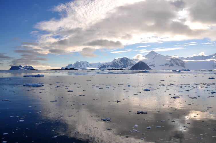
Nine fast-flowing glaciers in West Antarctica have been named after locations of important climate treaties, conferences and reports. One of the glaciers is now called Glasgow Glacier to mark the city hosting the COP26 climate change conference. All the glaciers are in the Getz region, which, using data from satellites, was found recently to have lost more than 300 gigatonnes of ice over the last 25 years.
TurboCADCAM
30.10.2021 18:40 ŠPINAR - softwareVážení zákazníci,
máme pro Vás připravený program TurboCADCAM, který spojuje východy CAD s CAM výstupy pro CNC obrábění.
The post TurboCADCAM appeared first on ŠPINAR – software.
TurboCADCAM
30.10.2021 18:40 ŠPINAR - software Vážení zákazníci,máme pro Vás připravený program TurboCADCAM, který spojuje východy CAD s CAM výstupy pro CNC obrábění.
Přerušení provozu DP a WSDP v pátek 5.11.2021 od 14:30 až do 7.11.2021 do cca 14:00.
29.10.2021 19:49 ČÚZK - předpisy a opatření Vážení uživatelé,oznamujeme, že v pátek 5.11.2021 od 14:30 bude z provozních důvodů zcela přerušen provoz Dálkového přístupu i Webových služeb dálkového přístupu. Obnovení provozu předpokládáme 7.11.2021 cca ve 14 hodin. U této verze nedochází ke změnám webových služeb, bude ukončeno poskytování WSDP verze 2.8 (zůstává tedy pouze verze 2.9).
Za komplikace tímto způsobené se omlouváme a děkujeme za pochopení.
Přerušení provozu DP a WSDP v pátek 5.11.2021 od 14:30 až do 7.11.2021 do cca 14:00.
29.10.2021 19:49 Dálkový přístup k údajům KN ČR Vážení uživatelé,oznamujeme, že v pátek 5.11.2021 od 14:30 bude z provozních důvodů zcela přerušen provoz Dálkového přístupu i Webových služeb dálkového přístupu. Obnovení provozu předpokládáme 7.11.2021 cca ve 14 hodin. U této verze nedochází ke změnám webových služeb, bude ukončeno poskytování WSDP verze 2.8 (zůstává tedy pouze verze 2.9).
Za komplikace tímto způsobené se omlouváme a děkujeme za pochopení.
Přerušení provozu DP a WSDP v pátek 5.11.2021 od 14:30 až do 7.11.2021 do cca 14:00.
29.10.2021 19:49 ČÚZK /Aplikace-DP-do-KN/Aplikace-DP-do-KN/Archiv-DP/337102Velodyne Lidar Showcases Automotive Lidar Solutions at Auto Guangzhou 2021
29.10.2021 17:12 GISCafe.com Webcasts-Webinars SAN JOSE, Calif. — (BUSINESS WIRE) — October 28, 2021 —Velodyne Lidar, Inc. (Nasdaq: VLDR, VLDRW) will demonstrate its innovative …
L3Harris Technologies Reports Third Quarter 2021 Results
29.10.2021 17:12 GISCafe.com Webcasts-Webinars Orders and revenueOrders of $4.5 billion; funded book-to-bill of 1.07
Revenue of $4.2 billion, down 5% versus prior year, and down 1% on an …
senseFly, an AgEagle Company, Named to Blue sUAS 2.0 List of Drone Suppliers by the U.S. Defense Innovation Unit
29.10.2021 17:12 GISCafe.com Webcasts-Webinars WICHITA, Kan. and LAUSANNE, Switzerland, Oct. 29, 2021 (GLOBE NEWSWIRE) -- AgEagle Aerial Systems Inc. (NYSE American: UAVS) (“AgEagle” or …New tethered drone system enables Mavic 2 drone to autonomously take off, follow, and land safely on small vessels
29.10.2021 17:12 GISCafe.com Webcasts-Webinars V-Line Boat Mode consist of hardware and software add-ons to V-Line such that tethered Mavic 2 series can be used autonomously on a boat.SINGAPORE, …
Spytec GPS Partners with Google Maps, Launches Tracking History Feature
29.10.2021 17:12 GISCafe.com Webcasts-Webinars NEW YORK, Oct. 29, 2021 — (PRNewswire) — Spytec GPS today launched Time Machine, a feature providing small businesses a …
Nová verzia ZBGIS
29.10.2021 10:25
ÚGKK SR
GKÚ pre Vás pripravilo novú verziu geoportálu ZBGIS 4.5 s nasadením od 28.10.2021 s množstvom noviniek.
Earth from Space: Glasgow
29.10.2021 10:00 ESA Observing the Earth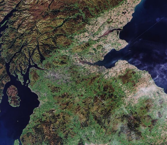
Glasgow, host of the 26th UN Climate Change Conference of Parties (COP26), is featured in this image captured by the Copernicus Sentinel-2 mission.
Interview with Daryl Madden, VP, Textron Systems Geospatial
29.10.2021 9:00 GISCafe.com Webcasts-WebinarsGetech Releases Heat Seeker – a New Paradigm for Geothermal Energy Exploration
29.10.2021 9:00 GISCafe.com Webcasts-Webinars Getech, a provider of geoscience data, knowledge, and software to the energy and strategic minerals industries, has …EuroGeographics contributes to COP26 call for governments to recognise value of location in climate change action
29.10.2021 9:00 GISCafe.com Webcasts-Webinars EuroGeographics pan-European datasets and their role in cross-border climate action are highlighted in a COP26 briefing paper calling on governments …"Intermap Makes Geospatial and Analytical Data Accessible to Everybody" by Susan Smith
29.10.2021 9:00 GISCafe.com Webcasts-WebinarsESA and NASA launch revolutionary open-source platform
29.10.2021 9:00 ESA Observing the Earth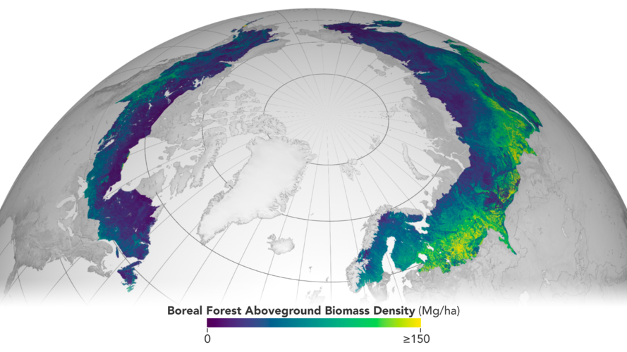
Today, ESA and NASA have publicly released the first globally-harmonised assessment of above ground biomass – information that is vital for managing global climate change. The Multi-Mission Algorithm and Analysis Platform (MAAP) provides seamless access to above ground biomass information from both NASA and ESA Earth observation data. The revolutionary open-science tool is now fully operational and accessible online.
Airbus reports Nine-Month (9m) 2021 results
29.10.2021 0:45 GISCafe.com Webcasts-Webinars 424 commercial aircraft delivered in 9m 20219m financials reflect deliveries as well as efforts on cost containment and competitiveness
Revenues …
Hexagon Interim Report 1 January - 30 September 2021
28.10.2021 19:15 GISCafe.com Webcasts-Webinars NACKA STRAND, Sweden, Oct. 28, 2021 — (PRNewswire) — Third quarter 2021Net sales increased by 15 per cent to 1,077.2 MEUR (939.9). …
Textron Reports Third Quarter 2021 Results; Raises Full Year EPS and Cash Guidance
28.10.2021 19:15 GISCafe.com Webcasts-Webinars EPS from continuing operations of $0.82; Adjusted EPS of $0.85Aviation backlog $3.5 billion at quarter-end, up $1.9 billion year to date
Net …
Ouster Doubles Digital Lidar Processing Power With New L2X Chip
28.10.2021 19:15 GISCafe.com Webcasts-Webinars L2X is designed to improve all-weather performance of Ouster’s scanning digital lidarSAN FRANCISCO — (BUSINESS WIRE) — October 28, …
Dedrone Empowers Ninth U.S. Federal Agency with Drone Detection & Mitigation Technology
28.10.2021 19:15 GISCafe.com Webcasts-Webinars Airspace security market leader enables federal operations to protect U.S. critical assets, soldiers and civilians around the globe from drone …Draganfly Completes Over 300 EMS Drone Delivery Test Flights in Texas
28.10.2021 19:15 GISCafe.com Webcasts-Webinars Draganfly, a global UAV leader, has successfully completed over 300 daytime test flights as it prepares to begin night flight training and testing …FinTech Global Ranks Maptycs Among Most Innovative Insurtech Providers Shaping the Future of the Industry
28.10.2021 19:15 GISCafe.com Webcasts-Webinars Maptycs is among the world's most innovative Insurtech companies that address the digital transformation challenges in insuranceNEW YORK, Oct. 28, …
Interview with Patrick Blott, Chairman and CEO, Intermap
28.10.2021 9:00 GISCafe.com Webcasts-WebinarsFARO Announces Third Quarter 2021 Financial Results
28.10.2021 2:33 GISCafe.com Webcasts-Webinars LAKE MARY, Fla., Oct. 27, 2021 — (PRNewswire) — FARO® (Nasdaq: FARO), a global leader of 3D measurement, imaging, and realization …20211027 - VŘ Vedoucí oddělení správy RÚIAN
27.10.2021 18:25 ČÚZK - aktuality v resortu Oznámení o vyhlášení výběrového řízení na obsazení služebního místa odborný rada - Vedoucí oddělení správy RÚIAN.20211027 - VŘ Vedoucí oddělení správy RÚIAN
27.10.2021 18:25 ČÚZK /Aktuality-resort/2021/20211027-VR-Vedouci-oddeleni-spravy-RUIAN20211027 - VŘ Vedoucí oddělení správy RÚIAN
27.10.2021 18:25 ČÚZK - předpisy a opatření Český úřad zeměměřický a katastrální zveřejnil novou aktualitu: Oznámení o vyhlášení výběrového řízení na obsazení služebního místa odborný rada - Vedoucí oddělení správy RÚIAN.Odborný rada - Vedoucí oddělení správy RÚIAN
27.10.2021 17:55 ČÚZK /Urady/Cesky-urad-zememericky-a-katastralni/Uredni-deska/Oznameni-a-jina-uredni-sdeleni/Volna-mista/DMS/Odborny-rada-Vedouci-oddeleni-spravy-RUIANOdborný rada - Vedoucí oddělení správy RÚIAN
27.10.2021 17:55 ČÚZK - předpisy a opatření Český úřad zeměměřický a katastrálnívypisuje výběrové řízení na místo
Odborný rada - Vedoucí oddělení správy RÚIAN
Odborný rada - Vedoucí oddělení správy RÚIAN
27.10.2021 17:55 ČÚZK - volná místa Český úřad zeměměřický a katastrální vypisuje výběrové řízení na místo Odborný rada - Vedoucí oddělení správy RÚIANDAEX DESIGN Start 22 v akční nabídce
27.10.2021 17:29 ŠPINAR - softwareVážení zákazníci,
v akční nabídce nyní můžete získat program pro navrhování nábytku a interiérů DAEX Start.
The post DAEX DESIGN Start 22 v akční nabídce appeared first on ŠPINAR – software.
DAEX DESIGN Start 22 v akční nabídce
27.10.2021 17:29 ŠPINAR - software Vážení zákazníci,v akční nabídce nyní můžete získat program pro navrhování nábytku a interiérů DAEX Start.
H3 Dynamics Launches World's Most Advanced Drone Charging Station, Targets Automation of the Global Drone Services Industry
27.10.2021 17:24 GISCafe.com Webcasts-Webinars SINGAPORE and PARIS and AUSTIN, Oct. 24, 2021 — (PRNewswire) — H3 Dynamics announces the launch of DBX-G7, a brand new …Teledyne Technologies Reports Third Quarter Results
27.10.2021 17:24 GISCafe.com Webcasts-Webinars THOUSAND OAKS, Calif. — (BUSINESS WIRE) — October 27, 2021 —Teledyne Technologies Incorporated (NYSE:TDY)
Record sales of …
Perrone Robotics Selects Ouster as a Preferred Lidar Supplier to Scale Autonomous Vehicle Deployments
27.10.2021 17:24 GISCafe.com Webcasts-Webinars Ouster to deliver hundreds of OS digital lidar sensors for Perrone’s autonomous vehicle kitSAN FRANCISCO — (BUSINESS WIRE) — October …
Intermap Signs New Master Services Agreement with Dewberry Under the $850 Million U.S. Geological Survey Geospatial Products and Services Contract
27.10.2021 17:23 GISCafe.com Webcasts-Webinars DENVER, Oct. 27, 2021 — (PRNewswire) — Intermap Technologies (TSX: IMP) (OTCQX: ITMSF) ("Intermap" or the "Company"), a global …CoreLogic Reports a 37.2% National Year-Over-Year Increase in Mortgage Fraud Risk in Second Quarter of 2021
27.10.2021 17:23 GISCafe.com Webcasts-Webinars An estimated 0.83% of all mortgage applications contained fraud, about 1 in 120 applicationsInvestment properties accounted for the highest-risk …
Planet Celebrates One Year of the NICFI Satellite Data Program, Providing High-Resolution Data for Tropical Forest Management
27.10.2021 17:23 GISCafe.com Webcasts-Webinars SAN FRANCISCO — (BUSINESS WIRE) — October 27, 2021 —Planet, a leading provider of daily data and insights about earth, is …
Nedostupné produkční prostředí ISÚI
27.10.2021 14:06 ČÚZK /ruian/Editacni-agendovy-system-ISUI/Provozni-informace-a-odstavky/Archiv-PROD/Nedostupne-produkcni-prostredi-ISUI-(27)20211027_Odborný rada – metodik katastru nemovitostí v oddělení metodiky a kontroly
27.10.2021 13:38 ČÚZK /Urady/Katastralni-urady/Katastralni-urady/Katastralni-urad-pro-Stredocesky-kraj/O-uradu/Aktuality/20210113_odborny-rada,-reditel-Katastralniho-(1)20211027_Odborný rada – metodik katastru nemovitostí v oddělení metodiky a kontroly
27.10.2021 13:38 ČÚZK - předpisy a opatření Katastrální úřad pro Středočeský kraj Vyhlášení výběrového řízení:Odborný rada – metodik katastru nemovitostí v oddělení metodiky a kontroly V části "Úřední deska", v sekci "Oznámení a jiná úřední sdělení" bylo vystaveno "Oznámení o vyhlášení výběrového řízení na obsazení systemizovaného místa Odborný rada – metodik katastru nemovitostí v oddělení metodiky a kontroly"Odborný rada – metodik katastru nemovitostí v oddělení metodiky a kontroly
27.10.2021 13:37 ČÚZK - volná místa Katastrální úřad pro Středočeský kraj vypisuje výběrové řízení na místo Odborný rada – metodik katastru nemovitostí v oddělení metodiky a kontrolyOdborný rada – metodik katastru nemovitostí v oddělení metodiky a kontroly
27.10.2021 13:37 ČÚZK /Urady/Katastralni-urady/Katastralni-urady/Katastralni-urad-pro-Stredocesky-kraj/Uredni-deska/Oznameni-a-jina-uredni-sdeleni/Volna-mista/Odborny-rada-–-metodik-katastru-nemovitosti-v-(1)Odborný rada – metodik katastru nemovitostí v oddělení metodiky a kontroly
27.10.2021 13:37 ČÚZK - předpisy a opatření Katastrální úřad pro Středočeský krajvypisuje výběrové řízení na místo Odborný rada – metodik katastru nemovitostí v oddělení metodiky a kontroly
Odborný rada – metodik katastru nemovitostí v oddělení metodiky a kontroly
Oznam pre geodetov
27.10.2021 13:20
ÚGKK SR
Od 27.10.2021 je spustená nová služba pre všetkých držiteľov preukazu geodeta, ktorá upozorňuje na blížiaci sa koniec platnosti preukazu
20211027_Rada / odborný rada – interní auditor Katastrálního úřadu pro Středočeský kraj
27.10.2021 13:10 ČÚZK /Urady/Katastralni-urady/Katastralni-urady/Katastralni-urad-pro-Stredocesky-kraj/O-uradu/Aktuality/20210113_odborny-rada,-reditel-Katastralniho-(10)20211027_Rada / odborný rada – interní auditor Katastrálního úřadu pro Středočeský kraj
27.10.2021 13:10 ČÚZK - předpisy a opatření Katastrální úřad pro Středočeský kraj Vyhlášení výběrového řízení:Rada / odborný rada – interní auditor Katastrálního úřadu pro Středočeský kraj V části "Úřední deska", v sekci "Oznámení a jiná úřední sdělení" bylo vystaveno "Oznámení o vyhlášení výběrového řízení na obsazení systemizovaného místa Rada / odborný rada – interní auditor Katastrálního úřadu pro Středočeský kraj"Rada / odborný rada – interní auditor Katastrálního úřadu pro Středočeský kraj
27.10.2021 13:09 ČÚZK - předpisy a opatření Katastrální úřad pro Středočeský krajvypisuje výběrové řízení na místo Rada / odborný rada – interní auditor Katastrálního úřadu pro Středočeský kraj
Rada / odborný rada – interní auditor Katastrálního úřadu pro Středočeský kraj