


![]()

zprávy
zdroje zpráv:Vedoucí oddělení metodiky a kontroly – odborný rada Katastrálního úřadu pro Středočeský kraj
14.1.2021 11:32 ČÚZK /Urady/Katastralni-urady/Katastralni-urady/Katastralni-urad-pro-Stredocesky-kraj/Uredni-deska/Oznameni-a-jina-uredni-sdeleni/Volna-mista/Vedouci-oddeleni-metodiky-a-kontroly-–-odborny-radRada/Odborný rada – Oddělení obnovy katastrálního operátu 1
14.1.2021 10:25 ČÚZK - volná místa Katastrální úřad pro Karlovarský kraj vypisuje výběrové řízení na místo Rada/Odborný rada – Oddělení obnovy katastrálního operátu 1Rada/Odborný rada – Oddělení obnovy katastrálního operátu 1
14.1.2021 10:25 ČÚZK /Urady/Katastralni-urady/Katastralni-urady/Katastralni-urad-pro-Karlovarsky-kraj/Uredni-deska/Oznameni-a-jina-uredni-sdeleni/Volna-mista/DMS/Rada-Odborny-rada-–-Oddeleni-obnovy-katastralnihoRada/Odborný rada – Oddělení obnovy katastrálního operátu 1
14.1.2021 10:25 ČÚZK - předpisy a opatření Katastrální úřad pro Karlovarský krajvypisuje výběrové řízení na místo
Rada/Odborný rada – Oddělení obnovy katastrálního operátu 1
Unicorn společně s CETIN začal budovat Webový geografický informační systém
14.1.2021 10:07 Unicorn Po zhruba 10 letech přistoupil CETIN ke generační obměně lehkého klienta GIS. S tím se pojí i zásadní změna technologie, konkrétně přechod na platformu Esri. Společně s Unicorn začal CETIN budovat systém, který zajistí přehlednou prezentaci síťové infrastruktury nad mapou.20210114_vrchní referent/ rada v oddělení právních vztahů k nemovitostem
14.1.2021 7:52 ČÚZK - předpisy a opatření Katastrální úřad pro Středočeský kraj - Katastrální pracoviště Beroun Vyhlášení výběrového řízení: odborný referent v oddělení dokumentace KN V části "Úřední deska", v sekci "Oznámení a jiná úřední sdělení" bylo vystaveno "Oznámení o vyhlášení výběrového řízení na obsazení služebního místa vrchní referent/ rada v oddělení právních vztahů k nemovitostem "20210113_odborný referent v oddělení dokumentace KN
14.1.2021 7:52 ČÚZK /Urady/Katastralni-urady/Katastralni-urady/Katastralni-urad-pro-Stredocesky-kraj/Katastralni-pracoviste/KP-Beroun/O-uradu/Aktuality/20210113_odborny-rada,-reditel-Katastralniho-praco20210114_vrchní referent/ rada v oddělení právních vztahů k nemovitostem
14.1.2021 7:52 ČÚZK /Urady/Katastralni-urady/Katastralni-urady/Katastralni-urad-pro-Stredocesky-kraj/Katastralni-pracoviste/KP-Beroun/O-uradu/Aktuality/20210113_odborny-rada,-reditel-Katastralniho-pracovrchní referent/ rada v oddělení právních vztahů k nemovitostem
14.1.2021 7:51 ČÚZK /Urady/Katastralni-urady/Katastralni-urady/Katastralni-urad-pro-Stredocesky-kraj/Uredni-deska/Oznameni-a-jina-uredni-sdeleni/Volna-mista/vrchni-referent-rada-v-oddeleni-pravnich-vztahu-kvrchní referent/ rada v oddělení právních vztahů k nemovitostem
14.1.2021 7:51 ČÚZK - předpisy a opatření Katastrální úřad pro Středočeský kraj - Katastrální pracoviště Berounvypisuje výběrové řízení na místo vrchní referent/ rada v oddělení právních vztahů k nemovitostem
vrchní referent/ rada v oddělení právních vztahů k nemovitostem
vrchní referent/ rada v oddělení právních vztahů k nemovitostem
14.1.2021 7:51 ČÚZK - volná místa Katastrální úřad pro Středočeský kraj - Katastrální pracoviště Beroun vypisuje výběrové řízení na místo vrchní referent/ rada v oddělení právních vztahů k nemovitostem20210113_odborný referent v oddělení dokumentace KN
14.1.2021 7:31 ČÚZK /Urady/Katastralni-urady/Katastralni-urady/Katastralni-urad-pro-Stredocesky-kraj/Katastralni-pracoviste/KP-Rakovnik/O-uradu/Aktuality/20210113_odborny-rada,-reditel-Katastralniho-praco20210113_odborný referent v oddělení dokumentace KN
14.1.2021 7:31 ČÚZK - předpisy a opatření Katastrální úřad pro Středočeský kraj - Katastrální pracoviště Rakovník Vyhlášení výběrového řízení: odborný referent v oddělení dokumentace KN V části "Úřední deska", v sekci "Oznámení a jiná úřední sdělení" bylo vystaveno "Oznámení o vyhlášení výběrového řízení na obsazení služebního místa odborný referent v oddělení dokumentace KN"odborný referent v oddělení dokumentace KN
14.1.2021 7:29 ČÚZK - předpisy a opatření Katastrální úřad pro Středočeský kraj - Katastrální pracoviště Rakovníkvypisuje výběrové řízení na místo odborný referent v oddělení dokumentace KN
odborný referent v oddělení dokumentace KN
odborný referent v oddělení dokumentace KN
14.1.2021 7:29 ČÚZK /Urady/Katastralni-urady/Katastralni-urady/Katastralni-urad-pro-Stredocesky-kraj/Uredni-deska/Oznameni-a-jina-uredni-sdeleni/Volna-mista/odborny-referent-v-oddeleni-dokumentace-KNodborný referent v oddělení dokumentace KN
14.1.2021 7:29 ČÚZK - volná místa Katastrální úřad pro Středočeský kraj - Katastrální pracoviště Rakovník vypisuje výběrové řízení na místo odborný referent v oddělení dokumentace KNNaše produkty dávají zákazníkům smysl, těší technického ředitele Ing. Davida Nováka.
14.1.2021 1:00 VARS.cz
Naše produkty dávají zákazníkům smysl, těší technického ředitele Ing. Davida Nováka
14.1.2021 1:00 VARS.cz
AeroVironment to Acquire Arcturus UAV, Expanding Product Portfolio and Reach into Group 2 and 3 Unmanned Aircraft Systems Segments
14.1.2021 0:37 GISCafe.com Webcasts-Webinars Total transaction value of $405 million in cash and stockArcturus UAV’s complementary capabilities provide program diversification, increase …
: Public comment sought on update to the work of the CDB Standards Working Group, providing location in modeling, simulation, and gaming
14.1.2021 0:14 GISCafe.com Webcasts-Webinars
The CDB SWG plans minor and major revisions to the CDB standard used for storage, access, and modification of synthetic …
Cortex, T-REX & GeoFutures to Collaborate on National Geospatial Speaker Series
13.1.2021 23:58 GISCafe.com Webcasts-Webinars Launch of “GeoInnovation National Speaker Series” to shine a monthly spotlight on St. Louis’ rapidly emerging geospatial …CETIN bude pro prezentaci své síťové infrastruktury používat software Esri
13.1.2021 23:19 GeoBusinessPo zhruba deseti letech přistoupila firma CETIN ke generační obměně lehkého klienta GIS. S tím se pojí i zásadní změna technologie, konkrétně přechod na platformu Esri. Společně s firmou Unicorn začal CETIN budovat systém, který zajistí přehlednou prezentaci síťové infrastruktury nad mapou. Webový geografický informační systém (WGIS) umožňuje zefektivnit plánování FTTx sítě či poskytování telekomunikačních […]
The post CETIN bude pro prezentaci své síťové infrastruktury používat software Esri appeared first on GeoBusiness.
WISeKey develops WISeToken utility token, a blockchain-based asset for drones and robots to secure IoT interactions (drone-to-drone or people-to-drone), recognize and trust each other
13.1.2021 21:52 GISCafe.com Webcasts-Webinars WISeKey develops WISeToken utility token, a blockchain-based asset for drones and robots to secure IoT interactions (drone-to-drone or …RoboSense Announces The SOP Version Of Automotive-Grade, High-Performance, Solid-State LiDAR At CES2021
13.1.2021 21:52 GISCafe.com Webcasts-Webinars The RS-LiDAR-M1 Is Expected To Be Mass Produced In Q2 2021SHENZHEN, China — (BUSINESS WIRE) — January 13, 2021 —
RoboSense …
Zveřejnění obsahu informací poskytnutých na žádost dle zákona č. 106/1999 Sb. za rok 2021
13.1.2021 17:34 ČÚZK /Urady/Katastralni-urady/Katastralni-urady/Katastralni-urad-pro-Moravskoslezsky-kraj/Casto-hledane-informace/Poskytovani-informaci-106-1999-Sb/Zverejneni-obsahu-informaci-poskytnutych-na-za-(1)/Zverejneni-obsahu-informaci-poskytnutych-na-za-(3)Zveřejnění obsahu informací poskytnutých na žádost dle zákona č. 106/1999 Sb. za rok 2021
13.1.2021 17:34 ČÚZK - předpisy a opatření Katastrální úřad pro Moravskoslezský krajzveřejňuje obsah informace poskytnutých na žádost dle zákona č. 106/1999 Sb. za rok
2021
Ředitel/ka Ekonomického odboru
13.1.2021 17:05 Zeměměřický úřad Zeměměřický úřadvypisuje výběrové řízení na místo
Ředitel/ka Ekonomického odboru
Ředitel/ka Ekonomického odboru
13.1.2021 17:05 ČÚZK - předpisy a opatření Zeměměřický úřadvypisuje výběrové řízení na místo
Ředitel/ka Ekonomického odboru
Ředitel/ka Ekonomického odboru
13.1.2021 17:05 ČÚZK - volná místa Zeměměřický úřad vypisuje výběrové řízení na místo Ředitel/ka Ekonomického odboruŘeditel/ka Ekonomického odboru
13.1.2021 17:05 ČÚZK /Urady/Zememericky-urad/Uredni-deska/Oznameni-a-jina-uredni-sdeleni/Volna-mista/Reditel-ka-Ekonomickeho-odboru-(2)Annual TomTom Traffic Index Looks Back on the Year that Could Change Traffic Forever: One Fifth (19%) Less Congestion Globally*
13.1.2021 16:20 GISCafe.com Webcasts-Webinars Tenth edition provides detailed insights on traffic congestion levels in 416 cities in 57 countriesGlobal congestion levels down by average 26% …Sagetech Avionics Receives AFWERX Contract from the U.S. Air Force
13.1.2021 16:20 GISCafe.com Webcasts-Webinars Under the contract, Sagetech will develop certifiable component solutions for future detect-and-avoid systemsWHITE SALMON, Wash., Jan. 13, 2021 …
Rozpočet úřadu za rok 2021
13.1.2021 15:25 ČÚZK /Urady/Cesky-urad-zememericky-a-katastralni/Rozpocty/Rozpocet-uradu-za-rok-2021Rozpočet úřadu za rok 2021
13.1.2021 15:25 ČÚZK - předpisy a opatření Český úřad zeměměřický a katastrálnívystavuje rozpočet úřadu za rok
2021
Volná místa - do 05.3.2021
13.1.2021 14:40 ČÚZK /Urady/Katastralni-urady/Katastralni-urady/Katastralni-urad-pro-hlavni-mesto-Prahu/O-uradu/Aktuality/Volna-mista-do-23-1-2020-(1)Volná místa - do 05.3.2021
13.1.2021 14:40 ČÚZK - předpisy a opatření Katastrální úřad pro hlavní město Prahu - Katastrální pracoviště Praha zveřejnil novou aktualitu: Ředitel úřadu vyhlašuje výběrové řízení na služební místo:- rada/odborný rada - právník
- rada/odborný rada - vedoucí ekonomicko-správního oddělení
Volná místa - do 23.1.2020
13.1.2021 14:40 ČÚZK /Urady/Katastralni-urady/Katastralni-urady/Katastralni-urad-pro-hlavni-mesto-Prahu/O-uradu/Aktuality/Volna-mista-do-23-1-2020-(1)Volná místa - do 23.1.2020
13.1.2021 14:40 ČÚZK - předpisy a opatření Katastrální úřad pro hlavní město Prahu - Katastrální pracoviště Praha zveřejnil novou aktualitu: Ředitel úřadu vyhlašuje výběrové řízení na služební místo:referent KN – návrh zápisu, kontrola a zplatnění v PO VI.
referent KN – návrh zápisu, kontrola a zplatnění v PO VI.
13.1.2021 14:36 ČÚZK /Urady/Katastralni-urady/Katastralni-urady/Katastralni-urad-pro-hlavni-mesto-Prahu/Uredni-deska/Oznameni-a-jina-uredni-sdeleni/Volna-mista/DMS/Inzerat_PP-na-referent-zplatneni-v-PT11-do-PO-VIInzerát_PP na referent-zplatnění v PT11 do PO VI
13.1.2021 14:36 ČÚZK - volná místa Katastrální úřad pro hlavní město Prahu - Katastrální pracoviště Praha vypisuje výběrové řízení na místo Inzerát_PP na referent-zplatnění v PT11 do PO VIInzerát_PP na referent-zplatnění v PT11 do PO VI
13.1.2021 14:36 ČÚZK - předpisy a opatření Katastrální úřad pro hlavní město Prahu - Katastrální pracoviště Prahavypisuje výběrové řízení na místo
Inzerát_PP na referent-zplatnění v PT11 do PO VI
referent KN – návrh zápisu, kontrola a zplatnění v PO VI.
13.1.2021 14:36 ČÚZK - volná místa Katastrální úřad pro hlavní město Prahu - Katastrální pracoviště Praha vypisuje výběrové řízení na místo referent KN – návrh zápisu, kontrola a zplatnění v PO VI.referent KN – návrh zápisu, kontrola a zplatnění v PO VI.
13.1.2021 14:36 ČÚZK - předpisy a opatření Katastrální úřad pro hlavní město Prahu - Katastrální pracoviště Prahavypisuje výběrové řízení na místo
referent KN – návrh zápisu, kontrola a zplatnění v PO VI.
Inzerát_PP na referent-zplatnění v PT11 do PO VI
13.1.2021 14:36 ČÚZK /Urady/Katastralni-urady/Katastralni-urady/Katastralni-urad-pro-hlavni-mesto-Prahu/Uredni-deska/Oznameni-a-jina-uredni-sdeleni/Volna-mista/DMS/Inzerat_PP-na-referent-zplatneni-v-PT11-do-PO-VIInformace o výsledcích kontrol dle § 26 zákona č. 255/2012 Sb. za rok 2020
13.1.2021 13:39 ČÚZK - předpisy a opatření Zeměměřický a katastrální inspektorát v Prazevydává informace o výsledcích kontrol dle § 26 zákona č. 255/2012 Sb. za rok 2020
2020
20210113_odborný rada, ředitel Katastrálního pracoviště
13.1.2021 12:03 ČÚZK - předpisy a opatření Katastrální úřad pro Středočeský kraj - Katastrální pracoviště Benešov Vyhlášení výběrového řízení: odborný rada, ředitel Katastrálního pracoviště V části "Úřední deska", v sekci "Oznámení a jiná úřední sdělení" bylo vystaveno "Oznámení o vyhlášení výběrového řízení na obsazení služebního místa odborný rada, ředitel Katastrálního pracoviště"20210113_odborný rada, ředitel Katastrálního pracoviště
13.1.2021 12:03 ČÚZK /Urady/Katastralni-urady/Katastralni-urady/Katastralni-urad-pro-Stredocesky-kraj/O-uradu/Aktuality/20210113_odborny-rada,-reditel-Katastralniho-praco20210113_odborný rada, ředitel Katastrálního pracoviště
13.1.2021 12:01 ČÚZK /Urady/Katastralni-urady/Katastralni-urady/Katastralni-urad-pro-Stredocesky-kraj/Katastralni-pracoviste/KP-Benesov/O-uradu/Aktuality/20210113_odborny-rada,-reditel-Katastralniho-praco20210113_odborný rada, ředitel Katastrálního pracoviště
13.1.2021 12:01 ČÚZK - předpisy a opatření Katastrální úřad pro Středočeský kraj - Katastrální pracoviště Benešov Vyhlášení výběrového řízení: odborný rada, ředitel Katastrálního pracoviště V části "Úřední deska", v sekci "Oznámení a jiná úřední sdělení" bylo vystaveno "Oznámení o vyhlášení výběrového řízení na obsazení služebního místa odborný rada, ředitel Katastrálního pracoviště"odborný rada - ředitel Katastrálního pracoviště
13.1.2021 11:58 ČÚZK /Urady/Katastralni-urady/Katastralni-urady/Katastralni-urad-pro-Stredocesky-kraj/Uredni-deska/Oznameni-a-jina-uredni-sdeleni/Volna-mista/odborny-rada-reditel-Katastralniho-pracovisteodborný rada - ředitel Katastrálního pracoviště
13.1.2021 11:58 ČÚZK - volná místa Katastrální úřad pro Středočeský kraj - Katastrální pracoviště Benešov vypisuje výběrové řízení na místo odborný rada - ředitel Katastrálního pracovištěodborný rada - ředitel Katastrálního pracoviště
13.1.2021 11:58 ČÚZK - předpisy a opatření Katastrální úřad pro Středočeský kraj - Katastrální pracoviště Benešovvypisuje výběrové řízení na místo odborný rada - ředitel Katastrálního pracoviště
odborný rada - ředitel Katastrálního pracoviště
Spain’s chilly blanket
13.1.2021 11:54 ESA Observing the Earth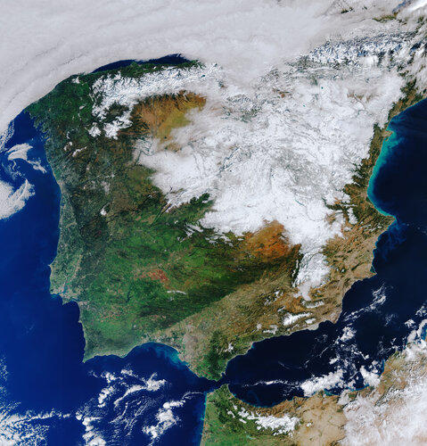 Image:
The heavy snowfall that hit Spain a few days ago still lies heavy across much of the country as this Copernicus Sentinel-3 satellite image shows.
Image:
The heavy snowfall that hit Spain a few days ago still lies heavy across much of the country as this Copernicus Sentinel-3 satellite image shows.
Upozornění: Ukončení přístupu k obsahu ArcGIS Online pro aplikace v API pro Flex a Silverlight
13.1.2021 11:15 ARCDATAV souvislosti s koncem životnosti technologií Flash a Silverlight plánuje společnost Esri během roku 2021 ukončit přístup aplikací vytvořených pomocí API pro Flex a Silverlight k obsahu a službám ArcGIS Online.
Přístup API pro Flex k ArcGIS Online bude ukončen k datu 26. 1. 2021. API pro Silverlight bude mít přístup do podzimu 2021, ukončení je plánováno k datu 12. 10. 2021.
Po uplynutí této doby již nebude možné přistupovat k obsahu a službám ArcGIS Online.
Kladno, Kuřim či Brno řeší využití fotovoltaiky na městských střechách. Pomáhá jim analýza oslunění z leteckých snímků (TZ)
13.1.2021 10:06 GISportal.cz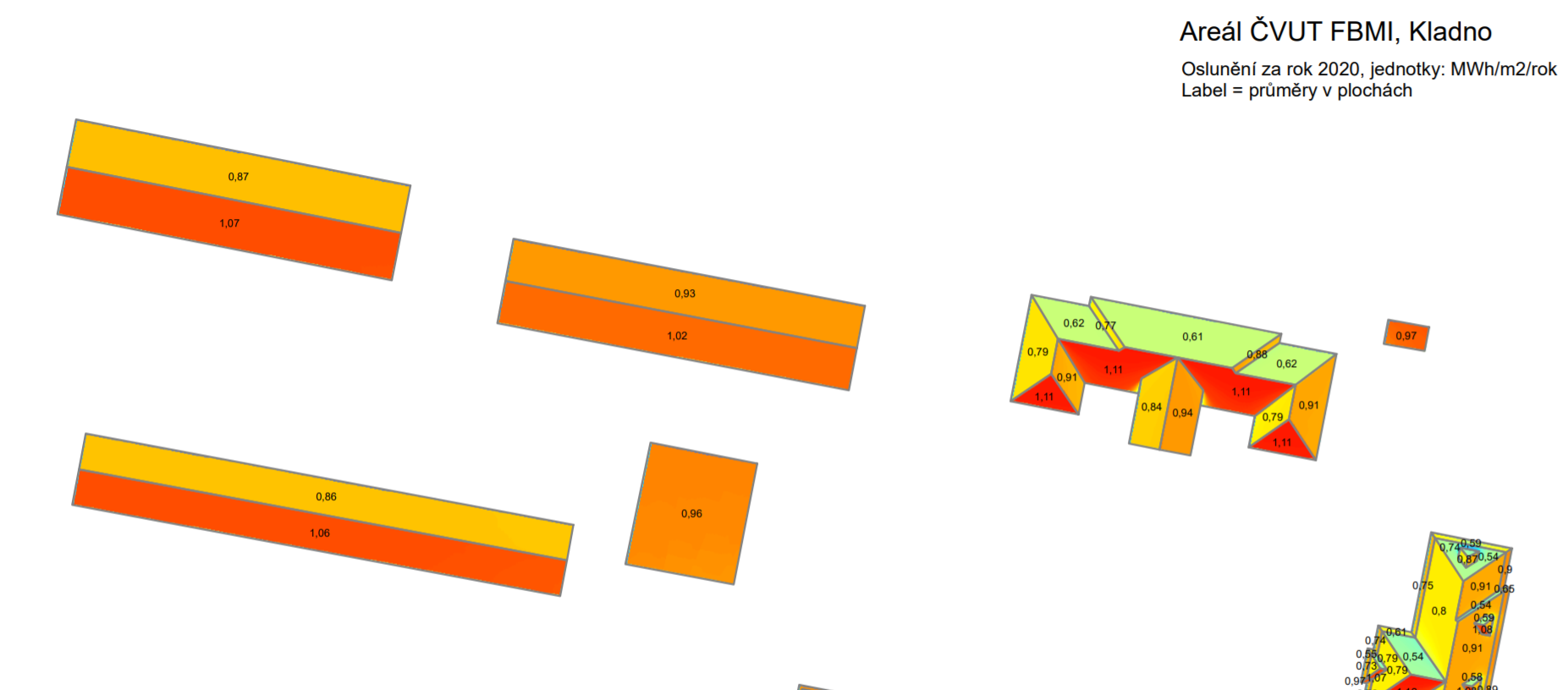
Větší podíl elektrické energie z obnovitelných zdrojů. Tímto tématem se v poslední době zabývá stále více obcí a měst v České republice. V Kladně, Kuřimi či v Brně si v nedávné době nechali zpracovat analýzu oslunění z leteckých snímků. Ta jim pomůže vybrat střechy budov, které jsou pro instalaci solárních panelů nejvhodnější. Vedení Kuřimi si v loňském roce nechalo provést analýzu oslunění u […]
The post Kladno, Kuřim či Brno řeší využití fotovoltaiky na městských střechách. Pomáhá jim analýza oslunění z leteckých snímků (TZ) appeared first on GISportal.cz.
Autonomous driving on intelligent road at Europe’s edge
13.1.2021 9:41 ESA Navigation
An ESA-supported effort put an intelligent road up in Finnish Lapland through its paces, assessing its suitability for testing autonomous vehicles in some of Europe’s most challenging driving conditions.
Mapová aplikace ÚPD - nové dokumentace
13.1.2021 9:40 Jihočeský kraj V mapové aplikaci Územně plánovací dokumentace obcí byla aktualizována ÚPD obcí ORP Vodňany – Krašlovice, ORP Strakonice – Volyně, ORP České Budějovice – Srubec, Lišov, České Budějovice, Staré Hodějovice20210113 – volné místo - Rada/odborný rada v OMaK kanceláře ředitele KÚ na Katastrálním úřadu pro ÚK
13.1.2021 8:20 ČÚZK /Urady/Katastralni-urady/Katastralni-urady/Katastralni-urad-pro-Ustecky-kraj/O-uradu/Aktuality/20210113-–-volne-misto-Rada-odborny-rada-v-OMaK20210113 – volné místo - Rada/odborný rada v OMaK kanceláře ředitele KÚ na Katastrálním úřadu pro ÚK
13.1.2021 8:20 ČÚZK - předpisy a opatření Katastrální úřad pro Ústecký kraj zveřejnil novou aktualitu: Nabídka volného pracovního místa - Rada/odborný rada v oddělení metodiky a kontroly kanceláře ředitele katastrálního úřadu na KÚ pro Ústecký krajRada/odborný rada v oddělení metodiky a kontroly kanceláře ředitele katastrálního úřadu na KÚ pro Ús
13.1.2021 8:13 ČÚZK /Urady/Katastralni-urady/Katastralni-urady/Katastralni-urad-pro-Ustecky-kraj/Uredni-deska/Oznameni-a-jina-uredni-sdeleni/Volna-mista/DMS/Rada-odborny-rada-v-oddeleni-metodiky-a-kontroly-kRada/odborný rada v oddělení metodiky a kontroly kanceláře ředitele katastrálního úřadu na KÚ pro Ús
13.1.2021 8:13 ČÚZK - volná místa Katastrální úřad pro Ústecký kraj kancelář ředitele vypisuje výběrové řízení na místo Rada/odborný rada v oddělení metodiky a kontroly kanceláře ředitele katastrálního úřadu na KÚ pro ÚsRada/odborný rada v oddělení metodiky a kontroly kanceláře ředitele katastrálního úřadu na KÚ pro Ús
13.1.2021 8:13 ČÚZK - předpisy a opatření Katastrální úřad pro Ústecký kraj kancelář ředitelevypisuje výběrové řízení na místo
Rada/odborný rada v oddělení metodiky a kontroly kanceláře ředitele katastrálního úřadu na KÚ pro Ústecký kraj
Video: Tvorba mapových podkladů pro variabilní aplikace v precizním zemědělství pomocí webového nástroje
13.1.2021 1:03 GeoBusinessV rámci série webinářů Otevřené jaro se uskutečnilo první setkání, věnované tvorbě mapových podkladů pro variabilní aplikace v precizním zemědělství pomocí webového nástroje. Pro čtenáře, co se nestihli přihlásit nebo přišli až po webináři, organizátoři připravili video záznam setkání.
The post Video: Tvorba mapových podkladů pro variabilní aplikace v precizním zemědělství pomocí webového nástroje appeared first on GeoBusiness.
ShadowBreak Intl and Axelspace Corporation Sign Partnership Agreement
12.1.2021 20:05 GISCafe.com Webcasts-Webinars January 12, 2021 -- London, United Kingdom -- Axelspace Corporation and ShadowBreak Intl have signed a partnership agreement enabling close …Orbbec Debuts New 3D Cameras for Wide Range of Uses, Including Pitch Black Environments, at CES 2021
12.1.2021 19:01 GISCafe.com Webcasts-Webinars Worldwide Leader in 3D Imaging Innovation Expands Product Line with Multiple New Products That Focus on Real-Time Industrial 3D Imaging and Time of …Odborný rada - Právník / Právnička
12.1.2021 17:14 ČÚZK /Urady/Cesky-urad-zememericky-a-katastralni/Uredni-deska/Oznameni-a-jina-uredni-sdeleni/Volna-mista/DMS/Odborny-rada-Pravnik-PravnickaOdborný rada - Právník / Právnička
12.1.2021 17:14 ČÚZK - volná místa Český úřad zeměměřický a katastrální vypisuje výběrové řízení na místo Odborný rada - Právník / PrávničkaOdborný rada - Právník / Právnička
12.1.2021 17:14 ČÚZK - předpisy a opatření Český úřad zeměměřický a katastrálnívypisuje výběrové řízení na místo
Odborný rada - Právník / Právnička
Cepton Introduces the World’s Smallest Wide Field of View Lidar Sensor for Near-Range Applications
12.1.2021 16:59 GISCafe.com Webcasts-Webinars Cepton’s miniature Nova lidar is easy to embed anywhere and costs less than $100 in high automotive volumesSAN JOSE, Calif. — (BUSINESS …
SOSLAB’s LiDAR ‘ML’ for Automotive Wins CES Innovation Award
12.1.2021 16:59 GISCafe.com Webcasts-Webinars Fish-eye Solid-state LiDAR released at CES 2021.GWANGJU, South Korea — (BUSINESS WIRE) — January 12, 2021 —
SOSLAB that …
Leveling Off: Mortgage Delinquencies Continue to Rise but Pace Moderating in October, CoreLogic Reports
12.1.2021 16:59 GISCafe.com Webcasts-Webinars Overall delinquency remains elevated compared to 2019, but is down from SeptemberLake Charles, Louisiana, continues with highest delinquency rates …
AgEagle Aerial Systems Announces State of Iowa Chooses HempOverview for Managing Registration and Oversight of Hemp Crops
12.1.2021 16:59 GISCafe.com Webcasts-Webinars WICHITA, Kan., Jan. 12, 2021 (GLOBE NEWSWIRE) -- AgEagle Aerial Systems Inc. (NYSE American: UAVS) (“AgEagle” or the “Company”), an …Leia Inc., Continental and HERE Technologies to pave the way in bringing freshest 3D maps to vehicles
12.1.2021 16:59 GISCafe.com Webcasts-Webinars HERE, Leia and Continental are bringing a cutting-edge navigation experience to automotive OEMs Leia’s Lightfield software allows for the …HERE releases 3D city models for industries to build reality-based applications and simulations
12.1.2021 16:59 GISCafe.com Webcasts-Webinars Precise geospatial data utilized in transportation, logistics, urban planning and government operations, filmmaking, videogame development and AR/VR …HERE offers privacy tools for enterprises to anonymize personal data and manage user consent globally
12.1.2021 16:59 GISCafe.com Webcasts-Webinars Technology currently used to deliver GDPR-compliant data services to connected vehicles CES 2021 – HERE Technologies, the leading location data …CES 2021 Taiwanese startup STO's indoor map bridges the gap of Google Maps
12.1.2021 16:59 GISCafe.com Webcasts-Webinars TAIPEI, Jan. 12, 2021 — (PRNewswire) — Spatial Topology Technology (STO) is the only indoor map platform embedded with both indoor …VYHLÁŠENÍ VÝBĚROVÉHO ŘÍZENÍ – vedoucí oddělení informací z KN
12.1.2021 15:13 ČÚZK - předpisy a opatření Katastrální úřad pro hlavní město Prahu zveřejnil novou aktualitu: Výběrové řízení – vedoucí oddělení informací z KN Ředitel Katastrálního úřadu pro hlavní město Prahu, jako služební orgán příslušný podle § 10odst. 1 písm. f) zákona č. 234/2014 Sb., o státní službě, ve znění pozdějších předpisů (dále
jen „zákon“), vyhlašuje výběrové řízení na služební místo:
rada/odborný rada – vedoucí
oddělení informací z KN a veřejných knih v odboru geodetických informací KN v oboru
služby Zeměměřictví a katastr nemovitostí se služebním působištěm Praha.
VYHLÁŠENÍ VÝBĚROVÉHO ŘÍZENÍ – vedoucí oddělení informací z KN
12.1.2021 15:13 ČÚZK - předpisy a opatření Katastrální úřad pro hlavní město Prahu - Katastrální pracoviště Praha zveřejnil novou aktualitu: Výběrové řízení – vedoucí oddělení informací z KN Ředitel úřadu vyhlašuje výběrové řízení na služební místo:rada/odborný rada – vedoucí oddělení informací z KN a veřejných knih
VYHLÁŠENÍ VÝBĚROVÉHO ŘÍZENÍ – vedoucí oddělení informací z KN
12.1.2021 15:13 ČÚZK /Urady/Katastralni-urady/Katastralni-urady/Katastralni-urad-pro-hlavni-mesto-Prahu/O-uradu/Aktuality/VYHLASENI-VYBEROVEHO-RIZENI-–-vedouci-oddeleni-infVYHLÁŠENÍ VÝBĚROVÉHO ŘÍZENÍ – vedoucí oddělení informací z KN
12.1.2021 15:13 ČÚZK - předpisy a opatření Katastrální úřad pro hlavní město Prahu zveřejnil novou aktualitu: Výběrové řízení – vedoucí oddělení informací z KN Ředitel úřadu vyhlašuje výběrové řízení na služební místo:rada/odborný rada – vedoucí oddělení informací z KN a veřejných knih
KÚ-00209-2020-100-01001 86-Oznameni_o_vyhlaseni_VŘ-představený-poz_kniha2_signed
12.1.2021 14:52 ČÚZK - volná místa Katastrální úřad pro hlavní město Prahu vypisuje výběrové řízení na místo KÚ-00209-2020-100-01001 86-Oznameni_o_vyhlaseni_VŘ-představený-poz_kniha2_signedrada/odborný rada – vedoucí oddělení informací z KN a veřejných knih
12.1.2021 14:52 ČÚZK - předpisy a opatření Katastrální úřad pro hlavní město Prahu - Katastrální pracoviště Prahavypisuje výběrové řízení na místo
rada/odborný rada – vedoucí oddělení informací z KN a veřejných knih
rada/odborný rada – vedoucí oddělení informací z KN a veřejných knih
12.1.2021 14:52 ČÚZK /Urady/Katastralni-urady/Katastralni-urady/Katastralni-urad-pro-hlavni-mesto-Prahu/Uredni-deska/Oznameni-a-jina-uredni-sdeleni/Volna-mista/DMS/KU-00209-2020-100-01001-86-Oznameni_o_vyhlaseni_VRKÚ-00209-2020-100-01001 86-Oznameni_o_vyhlaseni_VŘ-představený-poz_kniha2_signed
12.1.2021 14:52 ČÚZK - předpisy a opatření Katastrální úřad pro hlavní město Prahuvypisuje výběrové řízení na místo
KÚ-00209-2020-100-01001 86-Oznameni_o_vyhlaseni_VŘ-představený-poz_kniha2_signed
rada/odborný rada – vedoucí oddělení informací z KN a veřejných knih
12.1.2021 14:52 ČÚZK - volná místa Katastrální úřad pro hlavní město Prahu - Katastrální pracoviště Praha vypisuje výběrové řízení na místo rada/odborný rada – vedoucí oddělení informací z KN a veřejných knihKÚ-00209-2020-100-01001 86-Oznameni_o_vyhlaseni_VŘ-představený-poz_kniha2_signed
12.1.2021 14:52 ČÚZK /Urady/Katastralni-urady/Katastralni-urady/Katastralni-urad-pro-hlavni-mesto-Prahu/Uredni-deska/Oznameni-a-jina-uredni-sdeleni/Volna-mista/DMS/KU-00209-2020-100-01001-86-Oznameni_o_vyhlaseni_VRODSTÁVKA MAPOVÝCH SLUŽEB
12.1.2021 14:10 Plzeňský kraj Od úterý 12.01.2021 dojde k odstávce interaktivních mapových aplikací v technologii Flash. Mapy budou postupně upravovány. Za vzniklé potíže se omlouváme.ODSTÁVKA MAPOVÝCH SLUŽEB
12.1.2021 14:10 Plzeňský kraj Od úterý 12.01.2021 dojde k odstávce interaktivních mapových aplikací v technologii Adobe Flash. Mapy budou postupně upravovány. Za vzniklé potíže se omlouváme.odborný referent v oddělení obnovy katastrálního operátu č. 3 na Technické sekci
12.1.2021 13:43 ČÚZK /Urady/Katastralni-urady/Katastralni-urady/Katastralni-urad-pro-Jihomoravsky-kraj/Uredni-deska/Oznameni-a-jina-uredni-sdeleni/Volna-mista/DMS/odborny-referent-v-oddeleni-obnovy-katastralniho-oodborný referent v oddělení obnovy katastrálního operátu č. 3 na Technické sekci
12.1.2021 13:43 ČÚZK - předpisy a opatření Katastrální úřad pro Jihomoravský kraj technická sekcevypisuje výběrové řízení na místo
odborný referent v oddělení obnovy katastrálního operátu č. 3 na Technické sekci
odborný referent v oddělení obnovy katastrálního operátu č. 3 na Technické sekci
12.1.2021 13:43 ČÚZK - volná místa Katastrální úřad pro Jihomoravský kraj technická sekce vypisuje výběrové řízení na místo odborný referent v oddělení obnovy katastrálního operátu č. 3 na Technické sekciMadrid snowbound
12.1.2021 13:35 ESA Observing the Earth Image:
This Copernicus Sentinel-2 image of Madrid in Spain appears to have been taken in black and white. In fact, it is a true-colour image – but the heaviest snowfall in 50 years has blanketed the region, turning the landscape white.
Image:
This Copernicus Sentinel-2 image of Madrid in Spain appears to have been taken in black and white. In fact, it is a true-colour image – but the heaviest snowfall in 50 years has blanketed the region, turning the landscape white.
Výroční zpráva dle zákona č. 106/1999 Sb. za rok 2020
12.1.2021 10:23 ČÚZK /Urady/Katastralni-urady/Katastralni-urady/Katastralni-urad-pro-Karlovarsky-kraj/Vyrocni-zpravy/Vyrocni-zprava-dle-zakona-c-106-1999-Sb-za-rok-(3)Výroční zpráva dle zákona č. 106/1999 Sb. za rok 2020
12.1.2021 10:23 ČÚZK - předpisy a opatření Katastrální úřad pro Karlovarský krajvydává výroční zprávu úřadu za rok
2020
Energy from solar wind favours the north
12.1.2021 9:40 ESA Observing the Earth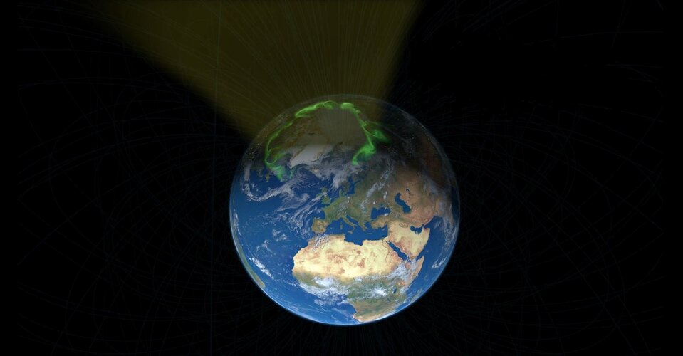
Using information from ESA’s Swarm satellite constellation, scientists have made a discovery about how energy generated by electrically-charged particles in the solar wind flows into Earth’s atmosphere – surprisingly, more of it heads towards the magnetic north pole than towards the magnetic south pole.
Rozpočet úřadu za rok 2021
12.1.2021 9:02 ČÚZK /Urady/Katastralni-urady/Katastralni-urady/Katastralni-urad-pro-Ustecky-kraj/Rozpocet/Rozpocet-uradu-za-rok-2021Rozpočet úřadu za rok 2021
12.1.2021 9:02 ČÚZK - předpisy a opatření Katastrální úřad pro Ústecký krajvystavuje rozpočet úřadu za rok
2021
Satlab Introduces the New Range of GNSS Receivers
12.1.2021 4:38 Satlab GeosolutionsSweden, 12 October 2018 Satlab Geosolutions released the next generation Global Navigation Satellite System (GNSS) receivers (SL700, SL800 and SL900) for real-time network applications. Powered by NovAtel OEM729 GNSS engine, the Continuously Operating Reference Station (CORS) receiver provides users and operators with access to multiple constellations and signals as well as 555 channel tracking capabilities. […]
The post Satlab Introduces the New Range of GNSS Receivers appeared first on SatLab – Global Satellite Positioning Solutions.
Ušetřete 33 % na CAD/CAM/CAE aplikaci Autodesk Fusion 360
12.1.2021 1:00 CAD Studio K nejpopulárnějším a nejvyužívanějším nástrojům pro moderní strojírenskou konstrukci patří CAD/CAM/CAE aplikace Autodesk Fusion 360. Pro usnadnění přechodu konstruktérů na její komerční licenci proto nyní vyhlašujeme krátkodobou slevu 33 % - kompletní ...Uzavření pobočky Česká Lípa
12.1.2021 0:00 Státní pozemkový úřad Dovolujeme si Vám oznámit, že z provozně technických důvodů je pro veřejnost uzavřena pobočka Česká Lípa. Veškerá vaše podání budou vyřizována elektronicky. Omezení platí do odvolání. O znovuotevření pobočky vás budeme neprodleně informovat. Děkujeme za pochopení.Využíjte novoroční akci
12.1.2021 0:00 Adeon Využíjte novoroční akci na licence Fusion 360 a získejte nové licence se slevou 33%.
Uzavření pobočky Česká Lípa
12.1.2021 0:00 Státní pozemkový úřad Dovolujeme si Vám oznámit, že z provozně technických důvodů je pro veřejnost uzavřena pobočka Česká Lípa. Veškerá vaše podání budou vyřizována elektronicky. Omezení platí do odvolání. O znovuotevření pobočky vás budeme neprodleně informovat. Děkujeme za pochopení.Ministerstvo vnitra spustilo svůj mapový rozcestník. Běží na ArcGIS Online
11.1.2021 23:31 GeoBusinessMinisterstva vnitra představilo svůj mapový portál s datovými vizualizacemi české veřejné správy. Spuštěn byl začátkem roku 2021 a celé řešení běží na webové platformě ArcGIS Online firmy Esri. Portál je k nahlédnutí na adrese https://portal-vnitro.hub.arcgis.com/ Hlavní mapové aplikace vizualizují údaje o obyvatelstvu, financování výkonu přenesené působnosti nebo vydávání osobních dokladů. Na portálu jsou k využití […]
The post Ministerstvo vnitra spustilo svůj mapový rozcestník. Běží na ArcGIS Online appeared first on GeoBusiness.
Společnost ENVIPARTNER, s.r.o. hledá nové kolegy
11.1.2021 20:51 Geografický ústav MUBrněnská společnost ENVIPARTNER, s.r.o. hledá nové kolegy na pozici zpracovatele vodohospodářských a krajinných projektů.
Více informací zde.
Updated Galileo OS SIS ICD now available
11.1.2021 18:19 European GNSS Agency
We are pleased to announce the release of the new Galileo Open Service Signal in Space Interface Control Document (OS SIS ICD v2.0). This second issue of the document is available for download in the Programme Reference Documents section of the European GNSS Service Centre (GSC) web portal.
The OS SIS ICD is geared towards Galileo receiver manufacturers and it specifies the interface between the Galileo Space Segment and the Galileo User Segment.
What’s new?
This new issue of the OS SIS ICD introduces major updates for all Galileo Open Service users. In particular, three new features are introduced to the I/NAV message transmitted on the Galileo E1-B signal component:
- Reduced Clock and Ephemeris Data (RedCED);
- Reed-Solomon Outer Forward Error Correction Data (FEC2); and
- Secondary Synchronization Pattern (SSP).
These new features represent a major evolution of the Galileo Open Service signals, which will provide all users with a more robust and faster retrieval of the Clock and Ephemeris Data, particularly for users in challenging environments, while at the same time allowing for a faster reconstruction of the Galileo System Time (GST).
This will result in a faster Time to First Fix for users whose receivers are able to exploit the new solutions. The new solutions are fully backward compatible, as they take advantage of parts of the I/NAV message previously marked as spare or reserved. This means that there will be no impact on legacy users and receivers that do not process these spare/reserved fields.
Advance preparation
Although these modified signals are not yet being broadcast by the Galileo satellites, this document will allow receiver manufacturers to prepare in advance. The Galileo Programme intends to support receiver manufacturers with the implementation of the new I/NAV capabilities, including by means of dedicated testing campaigns to be carried out in 2021-2022. The Galileo system is set to begin transmitting the new I/NAV capabilities by 2023.
The GSA will communicate with users through the usual channels about these possibilities in due time. For more details, please contact the Galileo Help Desk. Moreover, if you wish to receive NAGUs and notifications about new Galileo publications, please register on the GSC web portal and subscribe to our Newsletters.
Media note: This feature can be republished without charge provided the European GNSS Agency (GSA) is acknowledged as the source at the top or the bottom of the story. You must request permission before you use any of the photographs on the site. If you republish, we would be grateful if you could link back to the GSA website (http://www.gsa.europa.eu).
NV5 Geospatial Gains Momentum in Canada with Series of Topobathymetric Lidar and Aerial Imagery Wins in 2020
11.1.2021 15:55 GISCafe.com Webcasts-Webinars Projects Include Largest Survey of Major Waterways in Montreal and Extensive Aerial Imagery Surveys of Rail Corridors in Northern AlbertaHOLLYWOOD, …
Oddělení sběru dat Plzeň (ZÚ) hledá kolegu/kolegyni na pozici GEOGRAF/GEOGRAFKA
11.1.2021 15:34 Blogující geomatici - FAV ZČUMáme zde další nabídku na pracovní pozici, tentokrát od Zeměměřického úřadu, Oddělení sběru dat Plzeň, který hledá kolegu/kolegyni na pozici GEOGRAF/GEOGRAFKA.
Podrobné informace jsou uvedeny níže:
aktualizace digitálního geografického modelu ČR – ZABAGED®
pracoviště Zeměměřického úřadu v Plzni (Radobyčická 12)
Co je požadováno?
středoškolské vzdělání (ideálně geodetického nebo stavebního směru s povědomím o GIS a KN)
pečlivost, spolehlivost, samostatnost a odpovědnost
občanská bezúhonnost
Co je nabízeno?
zajímavá tvůrčí práci
přátelský kolektiv
pružná pracovní doba
systém zaměstnaneckých a sociálních výhod
Co byste ještě měli vědět?
Předpokládaný termín nástupu: 01. 02. 2021 (nebo dle dohody)
Smlouva: na dobu určitou (zástup za dlouhodobě nemocného kolegu)
Typ pracovního vztahu: dle vzájemné dohody (může být plný i částečný úvazek)
Kontakt:
Mgr. Jan Koubek
Zeměměřický úřad, Oddělení sběru dat Plzeň
tel. 377 162 122, 731 150 732