


![]()

zprávy
zdroje zpráv:Omezení úředních hodin 26.-30.10.2020
23.10.2020 10:24 ČÚZK /Urady/Katastralni-urady/Katastralni-urady/Katastralni-urad-pro-Pardubicky-kraj/O-uradu/Aktuality/Omezeni-urednich-hodin-26-30-10-2020Omezení úředních hodin 26.-30.10.2020
23.10.2020 10:24 ČÚZK - předpisy a opatření Katastrální úřad pro Pardubický kraj zveřejnil novou aktualitu: Omezení úředních hodin 26.-30.10.2020 Vážení klienti,v pondělí dne 26.10.2020 budou úřední hodiny v době od 8:00 do 17:00 hodin.
Ve středu 28.10.je státní svátek.
O dalších případných úpravách budete včas informováni.
Děkujeme za pochopení.
Earth from Space: Ganges Delta
23.10.2020 10:00 ESA Observing the Earth Video:
00:04:24
Video:
00:04:24
In this week's edition of the Earth from Space programme, we explore the Ganges Delta – the world’s largest river delta - with Copernicus Sentinel-3.
See also Ganges Delta to download the image.
Ganges Delta
23.10.2020 10:00 ESA Observing the Earth Image:
The Copernicus Sentinel-3 mission takes us over the Ganges Delta – the world’s largest river delta.
Image:
The Copernicus Sentinel-3 mission takes us over the Ganges Delta – the world’s largest river delta.
Úřední hodiny v týdnu 26. 10. až 30. 10. 2020
23.10.2020 9:19 ČÚZK /Urady/Katastralni-urady/Katastralni-urady/Katastralni-urad-pro-Liberecky-kraj/Katastralni-pracoviste/KP-Ceska-Lipa/O-uradu/Aktuality/Uredni-hodiny-v-tydnu-26-10-az-30-10-2020Úřední hodiny v týdnu 26. 10. až 30. 10. 2020
23.10.2020 9:19 ČÚZK - předpisy a opatření Katastrální úřad pro Liberecký kraj - Katastrální pracoviště Česká Lípa zveřejnil novou aktualitu:V souladu s výše citovaným usnesením Vlády České republiky je upřednostňován písemný, elektronický či telefonický kontakt před kontaktem osobním. Za uvedeným účelem žádáme klienty o upřednostnění kontaktu na dálku s využitím datové schránky, e-mailu, telefonu a zejména prostřednictvím sběrného boxu (podrobnosti níže v Aktualitách pracoviště).
Kontakty katastrálního pracoviště jsou zveřjněny na úvodní stránce. Kontakty na zaměstnance pracoviště jsou na adrese: https://www.cuzk.cz/Urady/Katastralni-urady/Katastralni-urady/Katastralni-urad-pro-Liberecky-kraj/Katastralni-pracoviste/KP-Ceska-Lipa/O-uradu/Kontakty.aspx
Děkujeme za pochopení.
New head of EuroGeographics aims to put official geospatial data on the map in the heart of Europe
23.10.2020 9:00 GISCafe.com Webcasts-Webinars EuroGeographics today (22 October 2020) announced European affairs advisor Léa Bodossian as its new Secretary General and Executive …Hera use Geospatial AI to prioritise its network to improve leakage detection and maintenance
23.10.2020 9:00 GISCafe.com Webcasts-Webinars Italian multi-utility, Hera Group, can increase productivity and reduce leakage thanks to the stellar combination of ISOIL Industria services and …EOFactory.ai - Disrupting traditional Earth Observation business models
23.10.2020 9:00 GISCafe.com Webcasts-Webinars We started EOfactory with a bold vision " To democratize EO intelligence towards a sustainable future"At EOfactory, our mission is to make EO data …Powerful analytics paired with robust satellite imagery: Aspectum and Planet enter into a partnership
23.10.2020 9:00 GISCafe.com Webcasts-Webinars New partnership that allows Aspectum users to access Planets high-resolution satellite imagery and rich geospatial dataAspectum and Planet have …
Avenza Releases Geographic Imager 6.2 for Adobe Photoshop
23.10.2020 9:00 GISCafe.com Webcasts-Webinars Includes Adobe Photoshop 2021 support Toronto, ON, October 21, 2020 - Avenza Systems Inc., producers of the Avenza Maps® app for mobile …
SBG Systems to release the virtual base station feature in Qinertia, its in-house post-processing software
23.10.2020 9:00 GISCafe.com Webcasts-Webinars Carrières-sur-seine, October 20th, 2020 – SBG Systems releases the Virtual Base Station feature in its in-house post-processing software …Aktualizace údajů
23.10.2020 8:41 Ústecký kraj V Geoportálu ÚAP Ústeckého kraje byla provedena aktualizace údajů pro poskytovatele Telco Pro Services, a. s.– jev 82a, ČEZ Distribuce, a. s. – jev 72, 73, 82a, České Radiokomunikace a.s. – jev 82a a Ústav pro hospodářskou úpravu lesů – jev 37a, B32.Porovnání funkcí v softwarech ArcGIS, QGIS a GRASS
23.10.2020 8:17 GeoBusinessTim Sutton (@timlinux) v roce 2017 založil otevřenou tabulku, ve které jsou vedle sebe srovnané funkce v softwarech Esri ArcGIS, QGIS a GRASS. Nově je také doplněn ArcGIS Pro, ale záleží na uživatelím, jak jej v tabulce doplní. Funkcí je hodně a tři softwary jsou mezi sebou velmi srovnatelné, ostatně podívejte se do tabulky. (Případně […]
The post Porovnání funkcí v softwarech ArcGIS, QGIS a GRASS appeared first on GeoBusiness.
rada / odborný rada – v oddělení aktualizace a dokumentace KN
23.10.2020 7:59 ČÚZK /Urady/Katastralni-urady/Katastralni-urady/Katastralni-urad-pro-Liberecky-kraj/Uredni-deska/Oznameni-a-jina-uredni-sdeleni/Volna-mista/rada-odborny-rada-–-v-oddeleni-aktualizace-a-drada / odborný rada – v oddělení aktualizace a dokumentace KN
23.10.2020 7:59 ČÚZK - předpisy a opatření Katastrální úřad pro Liberecký kraj - Katastrální pracoviště Jablonec nad Nisouvypisuje výběrové řízení na místo
rada / odborný rada – v oddělení aktualizace a dokumentace KN
rada / odborný rada – v oddělení aktualizace a dokumentace KN
23.10.2020 7:59 ČÚZK - volná místa Katastrální úřad pro Liberecký kraj - Katastrální pracoviště Jablonec nad Nisou vypisuje výběrové řízení na místo rada / odborný rada – v oddělení aktualizace a dokumentace KNBentley Systems to Announce Third Quarter 2020 Earnings; Presenting at an Upcoming Investor Conference
23.10.2020 4:55 Bentley SystemsEXTON, Pa.--(BUSINESS WIRE)--Bentley Systems, Incorporated (Nasdaq: BSY) (“Bentley Systems” or the “Company”) today announced the date for the release of its third quarter 2020 earnings and its presentation at an upcoming investor conference.
Third Quarter 2020 Financial Results
Bentley Systems will release third quarter 2020 earnings before the market opens on November 10, 2020.
A live Zoom Video Webinar of the event can be accessed at 8:30 a.m. Eastern Time that same day through a direct registration link at https://zoom.us/webinar/register/WN_MIBAJ7xHTN-cmp5KHRA-Fg. Alternatively, the event can be accessed from the Events & Presentations page on Bentley Systems’ Investor Relations website at https://investors.bentley.com. A replay and transcript will be available after the conclusion of the live event on Bentley Systems’ Investor Relations website.
Upcoming Investor Conference
Greg Bentley, Bentley Systems’ chief executive officer, will present at the Baird Global Industrial Virtual Conference at 7:05 a.m. Eastern Time on Wednesday, November 11, 2020. If you wish the access the live presentation, please email Baird Conference Services at bairdconferences@rwbaird.com. A replay of the presentation will be available through Bentley Systems’ Investor Relations website following the live event.
About Bentley Systems
Bentley Systems (Nasdaq: BSY) is the infrastructure engineering software company. We provide innovative software to advance the world’s infrastructure – sustaining both the global economy and environment. Our industry-leading software solutions are used by professionals, and organizations of every size, for the design, construction, and operations of roads and bridges, rail and transit, water and wastewater, public works and utilities, buildings and campuses, and industrial facilities. Our offerings include MicroStation-based applications for modeling and simulation, ProjectWise for project delivery, AssetWise for asset and network performance, and the iTwin platform for infrastructure digital twins. Bentley Systems employs more than 4,000 colleagues and generates annual revenues of more than $700 million, in 172 countries. www.bentley.com.
Contacts
Investors:
Carey Mann
Vice President, Investor Relations
ir@bentley.com
1-610-458-2777
Media:
Robin Robertson
Robin.Robertson@bentley.com
1-610-458-2985
CoreLogic Delivers Record Quarterly Revenue and Strong Double Digit Growth in Operating Income, Margins and Cash Flow
23.10.2020 1:32 GISCafe.com Webcasts-Webinars Double-Digit Revenue Growth Fueled by Housing Market Activity, Competitive Wins and Share GainsSignificant Increases in Profits and Margin Reflect …
O městě, krajině, umění
22.10.2020 20:59 Katedra geoinformatiky UP OlomoucMuzeum umění Olomouc právě virtuálně otevřelo novou výstavu O městě, krajině, umění. V úvodním videu se objevuje i mapa olomouckých památek, kterou pro muzeum sestavili naši studenti Radek Barvíř a Kuba Pospíšil Mapa doprovází knižní publikaci Meditace o městě, krajině, umění, která se brzy objeví na e-shopu. Jednotlivé exponáty pak budou prezentovány na Facebooku muzea. http://muo.cz/vystavu-o-meste-krajine-umeni-dnes-zahaji-virtualni-vernisaz–3543/?fbclid=IwAR13WRwGQ9FDMbf6hynpZ3HGzG9gsDZZKhBnf0G-N8mhC-9iw3f_ES0cGGc
The post O městě, krajině, umění appeared first on Katedra geoinformatiky.
30 tisíc korun pro vítěze v každé kategorii soutěže Společně otevíráme data
22.10.2020 20:05 GeoBusinessV osmém ročníku soutěže Společně otevíráme, pořádané Nadací OSF, data mohou o nejlepší aplikace soutěžit zájemci z řad veřejnosti, neziskových organizací, veřejných institucí, studentů i firem. Smyslem soutěže je rozvoj a zkvalitnění neziskových a občanských služeb pro společnost a zviditelnění přínosu práce s daty, specificky pak otevřených dat a open-source technologií prostřednictvím příkladů dobré praxe. […]
The post 30 tisíc korun pro vítěze v každé kategorii soutěže Společně otevíráme data appeared first on GeoBusiness.
Huawei Selects TomTom to Power Petal Maps
22.10.2020 20:00 GISCafe.com Webcasts-Webinars AMSTERDAM, Oct. 22, 2020 (GLOBE NEWSWIRE) -- TomTom (TOM2), the location technology specialist, today announced that Huawei has selected TomTom to …Prius Intelli Offers Free Access to* Aerial Imagery and GIS Services to Help Companies Make Business Decisions
22.10.2020 20:00 GISCafe.com Webcasts-Webinars FT. WORTH, Texas, Oct. 22, 2020 (GLOBE NEWSWIRE) -- Challenging times require extra measures for companies to succeed, and COVID-19 has indeed …LexisNexis Risk Solutions and Arturo Team Up to Deliver the Next Generation of Advanced Analytics-Powered Roof Solutions for U.S. Home Insurers
22.10.2020 20:00 GISCafe.com Webcasts-Webinars ATLANTA, Oct. 22, 2020 — (PRNewswire) — LexisNexis® Risk Solutions, a leading provider of data, advanced analytics and technology …Ware Raises Funding to Advance Warehouse Innovation, Drone Technology
22.10.2020 20:00 GISCafe.com Webcasts-Webinars Warehouse growth in 2020, plus increased e-commerce shopping, accelerates need for fast, accurate, automated inventory countsSAN FRANCISCO, Oct. 22, …
Videozáznam závěrečného webináře projektu EUXDAT, zaměřeného na extrémní datovou analytiku
22.10.2020 19:42 GeoBusinessTříletý projekt EUXDAT, financovanou Evropskou komisí, koncem letošního října končí. EUXDAT je zkratka pro European e-Infrastructure for Extreme Data Analytics in Sustainable Development. Projekt se zaměřoval na navržení digitální infrastruktury, zaměřené na zemědělství, monitorování půdy a energetickou účinnost pro udržitelný rozvoj, jako způsob podpory plánovacích politik. Pokud jste webinář z časových důvodů nestihli naživo, můžete […]
The post Videozáznam závěrečného webináře projektu EUXDAT, zaměřeného na extrémní datovou analytiku appeared first on GeoBusiness.
HazardHub launches an industry-first Catastrophic Flood Model
22.10.2020 18:46 GISCafe.com Webcasts-Webinars For the first time, you can determine the risk of a property from both maximum expected and catastrophic precipitation levels.SAN DIEGO, Oct. 22, …
BAE Systems Selected to Develop Attritable Air Vehicle Systems Under the U.S. Air Force Skyborg Program
22.10.2020 17:07 GISCafe.com Webcasts-Webinars ENDICOTT, N.Y. — (BUSINESS WIRE) — October 22, 2020 —BAE Systems has been awarded an indefinite delivery/indefinite quantity …
HERE integrates what3words into in-car navigation feature
22.10.2020 17:07 GISCafe.com Webcasts-Webinars Drivers will now be able to enter what3words addresses directly into their in-car systems, allowing them to navigate to any destination October 22, …Hivemapper Builds Global Decentralized Mapping Network, Offers Cash for Aerial and Ground-Level 3D Video
22.10.2020 17:06 GISCafe.com Webcasts-Webinars Hivemapper Studio provides easy, safe way to set up a side-hustle for your drone and driveBURLINGAME, Calif. — (BUSINESS WIRE) — October …
SEOSAT-Ingenio: fully loaded
22.10.2020 17:00 ESA Observing the Earth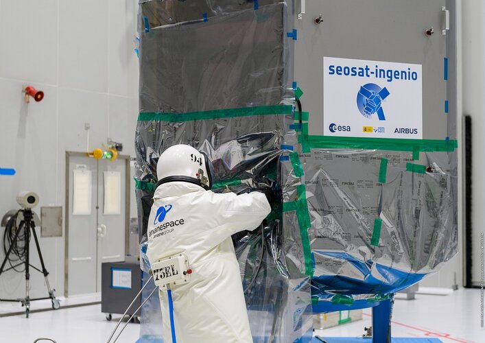
Preparations are well on track for the upcoming launch of SEOSAT-Ingenio – the Spanish high-resolution land imaging mission – scheduled to launch from Europe’s spaceport in French Guiana next month.
SEOSAT-Ingenio: fully loaded
22.10.2020 17:00 ESA Observing the Earth
Preparations are well on track for the upcoming launch of SEOSAT-Ingenio – the Spanish high-resolution land imaging mission – scheduled to launch from Europe’s spaceport in French Guiana next month.
Aktualizace dat ÚAP poskytovatelů ČEPRO a.s., ČEZ Distribuce a.s., ČEZ ICT Services a.s., NET4GAS s.r.o., Ředitelství silnic a dálnic a Telco Pro Services a.s.
22.10.2020 17:00 Plzeňský kraj V datech územně analytických podkladů Plzeňského kraje byla provedena kompletní aktualizace dat ve správě poskytovatelů ČEPRO a.s., ČEZ Distribuce a.s., ČEZ ICT Services a.s., NET4GAS s.r.o., Ředitelství silnic a dálnic a Telco Pro Services a.s.International Charter for disasters 20 years on
22.10.2020 14:49 ESA Observing the Earth
This week marks the 20th anniversary of the International Charter Space and Major Disasters. Founded by ESA, France’s CNES French Space Agency and the Canadian Space Agency, the Charter has been activated 680 times (as of 19 October 2020) to help to respond to disasters in 126 countries, including the earthquake and tsunami in the Indian Ocean in 2004, the earthquake in Haiti in 2010, Typhoon Haiyan in the South East Asia in 2013, and the explosion in Lebanon in 2020.
Změna úředních hodin
22.10.2020 14:48 ČÚZK - předpisy a opatření Katastrální úřad pro Jihomoravský kraj - Katastrální pracoviště Znojmo zveřejnil novou aktualitu: Z důvodu vyhlášených krizových opatření se v týdnu od 26.10.2020 omezují úřední hodiny katastrálních pracovišť Katastrálního úřadu pro Jihomoravský kraj na pondělí od 8:00 do 17:00Změna úředních hodin
22.10.2020 14:48 ČÚZK /Urady/Katastralni-urady/Katastralni-urady/Katastralni-urad-pro-Jihomoravsky-kraj/Katastralni-pracoviste/KP-Znojmo/O-uradu/Aktuality/Zmena-urednich-hodin-(1)Změna úředních hodin
22.10.2020 14:45 ČÚZK - předpisy a opatření Katastrální úřad pro Jihomoravský kraj - Katastrální pracoviště Vyškov zveřejnil novou aktualitu: Z důvodu vyhlášených krizových opatření se v týdnu od 26.10.2020 omezují úřední hodiny katastrálních pracovišť Katastrálního úřadu pro Jihomoravský kraj na pondělí od 8:00 do 17:00Změna úředních hodin
22.10.2020 14:45 ČÚZK /Urady/Katastralni-urady/Katastralni-urady/Katastralni-urad-pro-Jihomoravsky-kraj/Katastralni-pracoviste/KP-Vyskov/O-uradu/Aktuality/Zmena-urednich-hodin-(1)Změna úředních hodin
22.10.2020 14:42 ČÚZK - předpisy a opatření Katastrální úřad pro Jihomoravský kraj - Katastrální pracoviště Kyjov zveřejnil novou aktualitu: Z důvodu vyhlášených krizových opatření se v týdnu od 26.10.2020 omezují úřední hodiny katastrálních pracovišť Katastrálního úřadu pro Jihomoravský kraj na pondělí od 8:00 do 17:00Změna úředních hodin
22.10.2020 14:42 ČÚZK /Urady/Katastralni-urady/Katastralni-urady/Katastralni-urad-pro-Jihomoravsky-kraj/Katastralni-pracoviste/KP-Kyjov/O-uradu/Aktuality/Zmena-urednich-hodin-(1)20201023-Návštěvy katastrálních pracovišť v době pandemie
22.10.2020 14:35 ČÚZK /Aktuality-resort/2020/20201023-Navstevy-katastralnich-pracovist-v-dobe-p20201023-Návštěvy katastrálních pracovišť v době pandemie
22.10.2020 14:35 ČÚZK - předpisy a opatření Český úřad zeměměřický a katastrální zveřejnil novou aktualitu: S ohledem na vývoj pandemické situace v ČR Vás prosíme, abyste katastrální pracoviště navštěvovali jen v nejnutnějších případech a dali přednost zaslání podání elektronicky nebo poštou. Výpis z katastru v elektronické podobě je možno získat v e-shopu Nahlížení do katastru. V souladu s usnesením vlády ČR č. 1080 ze dne 21. října 2020 budou mít všechny katastrální úřady v týdnu od 26. října úřední den pouze v pondělí 26. října 2020, před návštěvou si prosím ověřte přesný rozsah úředních hodin na www stránkách příslušných katastrálních úřadů. Děkujeme za pochopení.20201030-Návštěvy katastrálních pracovišť v době pandemie
22.10.2020 14:35 ČÚZK /Aktuality-resort/2020/20201023-Navstevy-katastralnich-pracovist-v-dobe-p20201030-Návštěvy katastrálních pracovišť v době pandemie
22.10.2020 14:35 ČÚZK - předpisy a opatření Český úřad zeměměřický a katastrální zveřejnil novou aktualitu: S ohledem na vývoj pandemické situace v ČR Vás prosíme, abyste katastrální pracoviště navštěvovali jen v nejnutnějších případech a dali přednost zaslání podání elektronicky nebo poštou. Výpis z katastru v elektronické podobě je možno získat v e-shopu Nahlížení do katastru. V souladu s usnesením vlády ČR č. 1080 ze dne 21. října 2020 budou mít všechny katastrální úřady od 2. listopadu 2020 úřední dny pouze v pondělí a ve středu, před návštěvou si prosím ověřte přesný rozsah úředních hodin na www stránkách příslušných katastrálních úřadů. Děkujeme za pochopení.Změna úředních hodin
22.10.2020 14:30 ČÚZK /Urady/Katastralni-urady/Katastralni-urady/Katastralni-urad-pro-Jihomoravsky-kraj/Katastralni-pracoviste/KP-Hustopece/O-uradu/Aktuality/Zmena-urednich-hodin-(1)Změna úředních hodin
22.10.2020 14:30 ČÚZK - předpisy a opatření Katastrální úřad pro Jihomoravský kraj - Katastrální pracoviště Hustopeče zveřejnil novou aktualitu: Z důvodu vyhlášených krizových opatření se v týdnu od 26.10.2020 omezují úřední hodiny Katastrálního pracoviště Hustopeče na pondělí od 8:00 do 13:00Změna úředních hodin
22.10.2020 14:26 ČÚZK /Urady/Katastralni-urady/Katastralni-urady/Katastralni-urad-pro-Jihomoravsky-kraj/Katastralni-pracoviste/KP-Hodonin/O-uradu/Aktuality/Zmena-urednich-hodin-(1)Změna úředních hodin
22.10.2020 14:26 ČÚZK - předpisy a opatření Katastrální úřad pro Jihomoravský kraj - Katastrální pracoviště Hodonín zveřejnil novou aktualitu: Z důvodu vyhlášených krizových opatření se v týdnu od 26.10.2020 omezují úřední hodiny katastrálních pracovišť Katastrálního úřadu pro Jihomoravský kraj na pondělí od 8:00 do 17:00Změna úředních hodin
22.10.2020 14:22 ČÚZK - předpisy a opatření Katastrální úřad pro Jihomoravský kraj - Katastrální pracoviště Břeclav zveřejnil novou aktualitu: Z důvodu vyhlášených krizových opatření se v týdnu od 26.10.2020 omezují úřední hodiny katastrálních pracovišť Katastrálního úřadu pro Jihomoravský kraj na pondělí od 8:00 do 17:00Po dobu nouzového stavu bude kontaktní místo u Městského úřadu v Mikulově uzavřeno
Změna úředních hodin
22.10.2020 14:22 ČÚZK /Urady/Katastralni-urady/Katastralni-urady/Katastralni-urad-pro-Jihomoravsky-kraj/Katastralni-pracoviste/KP-Breclav/O-uradu/Aktuality/Zmena-urednich-hodin-(1)Změna úředních hodin
22.10.2020 14:17 ČÚZK - předpisy a opatření Katastrální úřad pro Jihomoravský kraj - Katastrální pracoviště Brno-venkov zveřejnil novou aktualitu: Z důvodu vyhlášených krizových opatření se v týdnu od 26.10.2020 omezují úřední hodiny katastrálních pracovišť Katastrálního úřadu pro Jihomoravský kraj na pondělí od 8:00 do 17:00Změna úředních hodin
22.10.2020 14:17 ČÚZK /Urady/Katastralni-urady/Katastralni-urady/Katastralni-urad-pro-Jihomoravsky-kraj/Katastralni-pracoviste/KP-Brno-venkov/O-uradu/Aktuality/Zmena-urednich-hodin-(1)Změna úředních hodin
22.10.2020 14:14 ČÚZK - předpisy a opatření Katastrální úřad pro Jihomoravský kraj - Katastrální pracoviště Brno-město zveřejnil novou aktualitu: Z důvodu vyhlášených krizových opatření se v týdnu od 26.10.2020 omezují úřední hodiny katastrálních pracovišť Katastrálního úřadu pro Jihomoravský kraj na pondělí od 8:00 do 17:00Změna úředních hodin
22.10.2020 14:14 ČÚZK /Urady/Katastralni-urady/Katastralni-urady/Katastralni-urad-pro-Jihomoravsky-kraj/Katastralni-pracoviste/KP-Brno-mesto/O-uradu/Aktuality/Zmena-urednich-hodin-(1)Změna úředních hodin
22.10.2020 14:11 ČÚZK - předpisy a opatření Katastrální úřad pro Jihomoravský kraj - Katastrální pracoviště Boskovice zveřejnil novou aktualitu: Z důvodu vyhlášených krizových opatření se v týdnu od 26.10.2020 omezují úřední hodiny katastrálních pracovišť Katastrálního úřadu pro Jihomoravský kraj na pondělí od 8:00 do 17:00Změna úředních hodin
22.10.2020 14:11 ČÚZK /Urady/Katastralni-urady/Katastralni-urady/Katastralni-urad-pro-Jihomoravsky-kraj/Katastralni-pracoviste/KP-Boskovice/O-uradu/Aktuality/Zmena-urednich-hodin-(1)Změna úředních hodin
22.10.2020 14:08 ČÚZK /Urady/Katastralni-urady/Katastralni-urady/Katastralni-urad-pro-Jihomoravsky-kraj/Katastralni-pracoviste/KP-Blansko/O-uradu/Aktuality/Zmena-urednich-hodin-(1)Změna úředních hodin
22.10.2020 14:08 ČÚZK - předpisy a opatření Katastrální úřad pro Jihomoravský kraj - Katastrální pracoviště Blansko zveřejnil novou aktualitu: Z důvodu vyhlášených krizových opatření se v týdnu od 26.10.2020 omezují úřední hodiny katastrálních pracovišť Katastrálního úřadu pro Jihomoravský kraj na pondělí od 8:00 do 17:00Omezení úředních hodin
22.10.2020 13:50 ČÚZK /Urady/Zememericke-a-katastralni-inspektoraty/Zememericke-a-katastralni-inspektoraty/Zememericky-a-katastralni-inspektorat-v-Liberci/O-uradu/Aktuality/Omezeni-urednich-hodin-(1)Omezení úředních hodin
22.10.2020 13:50 ČÚZK - předpisy a opatření Zeměměřický a katastrální inspektorát v Liberci zveřejnil novou aktualitu: Důležité upozornění!V návaznosti na usnesení vlády ČR ze dne 21. října 2020 č. 1080, o přijetí krizového opatření, se v době od 2. listopadu 2020 omezuje rozsah úředních hodin pro podatelnu i veřejnost takto: pondělí 8:00 - 13:00 hod. a středa 12:00 - 17:00 hod. Mimo tyto úřední hodiny lze vhodit podání v zalepené obálce do sběrného boxu Katastrálního úřadu pro Liberecký kraj, zpřístupněného u vstupu do budovy v běžných úředních hodinách. Žádáme klienty, aby přednostně využívali písemný, elektronický (e-mail, datová schránka) či telefonický kontakt.
Omezení úředních hodin
22.10.2020 13:50 ČÚZK - předpisy a opatření Zeměměřický a katastrální inspektorát v Liberci zveřejnil novou aktualitu: Důležité upozornění!V návaznosti na usnesení vlády ČR ze dne 21. října 2020 č. 1080, o přijetí krizového opatření, se v době od 22. října 2020 do 3. listopadu 2020 omezuje rozsah úředních hodin pro podatelnu i veřejnost takto: pondělí a středa 8:00 - 10:30 a 14:30 - 17:00 hodin. Mimo tyto úřední hodiny lze vhodit podání v zalepené obálce do sběrného boxu Katastrálního úřadu pro Liberecký kraj, zpřístupněného u vstupu do budovy v běžných úředních hodinách. Žádáme klienty, aby přednostně využívali písemný, elektronický (e-mail, datová schránka) či telefonický kontakt.
Změna úředních hodin
22.10.2020 13:22 ČÚZK /Urady/Katastralni-urady/Katastralni-urady/Katastralni-urad-pro-Jihomoravsky-kraj/O-uradu/Aktuality/Zmena-urednich-hodin-(2)Změna úředních hodin
22.10.2020 13:22 ČÚZK - předpisy a opatření Katastrální úřad pro Jihomoravský kraj zveřejnil novou aktualitu: Z důvodu vyhlášených krizových opatření se v týdnu od 26.10.2020 omezují úřední hodiny katastrálních pracovišť Katastrálního úřadu pro Jihomoravský kraj na pondělí od 8:00 do 17:00(s výjimkou Katastrálního pracoviště Hustopeče - pondělí od 8:00 do 13:00)
ÚPRAVA ÚŘEDNÍCH HODIN od 22.10.
22.10.2020 13:15 ČÚZK /Urady/Katastralni-urady/Katastralni-urady/Katastralni-urad-pro-Olomoucky-kraj/O-uradu/Aktuality/UPRAVA-UREDNICH-HODIN-od-22-10ÚPRAVA ÚŘEDNÍCH HODIN od 22.10.
22.10.2020 13:15 ČÚZK - předpisy a opatření Katastrální úřad pro Olomoucký kraj zveřejnil novou aktualitu: ÚPRAVA ÚŘEDNÍCH HODINS ohledem na opatření přijatá usnesením vlády ČR č. 1080 ze dne 21. října 2020
upravujeme úřední hodiny na všech katastrálních pracovištích v působnosti KÚ pro Olomoucký kraj
s platností do pátku 30. října 2020 na pondělí a středu 8:00 až 13:00 hodin.
Podrobné informace jsou uvedeny v přiloženém dokumentu (PDF).
Děkujeme za pochopení.
Odborný referent v oddělení obnovy katastrálního operátu č. 3
22.10.2020 12:53 ČÚZK /Urady/Katastralni-urady/Katastralni-urady/Katastralni-urad-pro-Jihomoravsky-kraj/Uredni-deska/Oznameni-a-jina-uredni-sdeleni/Volna-mista/DMS/Odborny-referent-v-oddeleni-obnovy-katastralniho-oOdborný referent v oddělení obnovy katastrálního operátu č. 3
22.10.2020 12:53 ČÚZK - předpisy a opatření Katastrální úřad pro Jihomoravský kraj technická sekcevypisuje výběrové řízení na místo
Odborný referent v oddělení obnovy katastrálního operátu č. 3
Odborný referent v oddělení obnovy katastrálního operátu č. 3
22.10.2020 12:53 ČÚZK - volná místa Katastrální úřad pro Jihomoravský kraj technická sekce vypisuje výběrové řízení na místo Odborný referent v oddělení obnovy katastrálního operátu č. 3Přijetí krizových opatření
22.10.2020 12:48 ČÚZK - předpisy a opatření Katastrální úřad pro Královéhradecký kraj zveřejnil novou aktualitu:Přijetí krizových opatření:
v návaznosti na Usnesení vlády ČR ze dne 21. 10. 2020 č. 1080 o přijetí krizového opatření oznamuje úpravu úředních hodin na katastrálních pracovištích takto:
Hradec Králové, Náchod, Rychnov nad Kněžnou a Trutnov:
pondělí a středa od 8:00 - 13:00
Jičín:
pondělí 9:00 - 14:00
středa 10:00 - 15:00
Více podrobností v oznámení.
Přijetí krizových opatření
22.10.2020 12:48 ČÚZK - předpisy a opatření Český úřad zeměměřický a katastrální zveřejnil novou aktualitu: Katastrální úřad pro Královéhradecký krajv návaznosti na Usnesení vlády ČR ze dne 21. 10. 2020 č. 1080 o přijetí krizového opatření oznamuje:
Všechna katastrální pracoviště v územní působnosti Katastrálního úřadu pro Královéhradecký kraj mají nadále omezeny služby vyžadující přímý kontakt s veřejností.
Na Katastrálních pracovištích Hradec Králové, Náchod, Rychnov nad Kněžnou a Trutnov jsou úřední hodiny od 22. 10. 2020 stanoveny takto: pondělí a středa od 8:00 do 13:00, na Katastrálním pracovišti Jičín: pondělí od 9:00 do 14:00 a středa od 10:00 do 15:00.
Pro příjem podání a poskytování údajů se upřednostňuje písemný, elektronický či telefonický kontakt před osobním kontaktem ve všech případech, kdy je to možné.
Návrhy na vklad práv i ostatní podání je možné činit prostřednictvím provozovatele poštovních služeb nebo elektronicky (e-mailem nebo prostřednictvím datových schránek). Podrobnosti o elektronických podáních a parametrech přijímaných datových zpráv zde: https://www.cuzk.cz/Katastr-nemovitosti/Zapisy-do-KN/Informace-o-elektronickem-podani.aspx. Účastníci řízení o povolení vkladu budou v těchto případech vyzváni k úhradě správního poplatku, který lze uhradit převodem na účet.
Údaje katastru nemovitostí lze získat i prostřednictvím aplikace Nahlížení do katastru https://nahlizenidokn.cuzk.cz/, kde je možné prostřednictvím e-shopu získat i úplný výpis z katastru nemovitostí v elektronické podobě, prostřednictvím aplikace Dálkový přístup https://www.cuzk.cz/aplikace-dp pro registrované uživatele, nebo na kontaktních místech státní správy Czech POINT.
Ing. Jaroslav Bačina v. r.
ředitel
V Hradci Králové dne 22. 10. 2020
Přijetí krizových opatření
22.10.2020 12:48 ČÚZK /Urady/Katastralni-urady/Katastralni-urady/Katastralni-urad-pro-Kralovehradecky-kraj/O-uradu/Aktuality/Prijeti-krizovych-opatreniPřijetí krizových opatření
22.10.2020 12:48 ČÚZK - předpisy a opatření Katastrální úřad pro Královéhradecký kraj zveřejnil novou aktualitu:Přijetí krizových opatření:
v návaznosti na Usnesení vlády ČR ze dne 21. 10. 2020 č. 1080 o přijetí krizového opatření oznamuje úpravu úředních hodin na katastrálních pracovištích takto:
Hradec Králové, Náchod, Rychnov nad Kněžnou a Trutnov:
pondělí a středa od 8:00–13:00
Jičín:
pondělí 9:00–14:00
středa 10:00–15:00
Více podrobností v oznámení.
Přijetí krizových opatření
22.10.2020 12:48 ČÚZK - předpisy a opatření Český úřad zeměměřický a katastrální zveřejnil novou aktualitu: Katastrální úřad pro Královéhradecký krajv návaznosti na Usnesení vlády ČR ze dne 21. 10. 2020 č. 1080 o přijetí krizového opatření oznamuje:
Všechna katastrální pracoviště v územní působnosti Katastrálního úřadu pro Královéhradecký kraj mají nadále omezeny služby vyžadující přímý kontakt s veřejností.
Na Katastrálních pracovištích Hradec Králové, Náchod, Rychnov nad Kněžnou a Trutnov jsou úřední hodiny od 22. 10. 2020 stanoveny takto: pondělí a středa od 8:00 do 17:00, na Katastrálním pracovišti Jičín: pondělí od 9:00 do 14:00 a středa od 10:00 do 15:00.
Pro příjem podání a poskytování údajů se upřednostňuje písemný, elektronický či telefonický kontakt před osobním kontaktem ve všech případech, kdy je to možné.
Návrhy na vklad práv i ostatní podání je možné činit prostřednictvím provozovatele poštovních služeb nebo elektronicky (e-mailem nebo prostřednictvím datových schránek). Podrobnosti o elektronických podáních a parametrech přijímaných datových zpráv zde: https://www.cuzk.cz/Katastr-nemovitosti/Zapisy-do-KN/Informace-o-elektronickem-podani.aspx. Účastníci řízení o povolení vkladu budou v těchto případech vyzváni k úhradě správního poplatku, který lze uhradit převodem na účet.
Údaje katastru nemovitostí lze získat i prostřednictvím aplikace Nahlížení do katastru https://nahlizenidokn.cuzk.cz/, kde je možné prostřednictvím e-shopu získat i úplný výpis z katastru nemovitostí v elektronické podobě, prostřednictvím aplikace Dálkový přístup https://www.cuzk.cz/aplikace-dp pro registrované uživatele, nebo na kontaktních místech státní správy Czech POINT.
Ing. Jaroslav Bačina v. r.
ředitel
V Hradci Králové dne 22. 10. 2020
Přijetí krizových opatření
22.10.2020 12:48 ČÚZK - předpisy a opatření Katastrální úřad pro Královéhradecký kraj zveřejnil novou aktualitu:V návaznosti na Usnesení vlády ČR ze dne 21. 10. 2020 č. 1080 o přijetí krizového opatření oznamuje úpravu úředních hodin na katastrálních pracovištích takto:
Hradec Králové, Náchod, Rychnov nad Kněžnou a Trutnov: pondělí a středa od 8:00 - 13:00
Jičín: pondělí 9:00 - 14:00 a středa 10:00 - 15:00
Více podrobností v oznámení.
rada / odborný rada – operátor informačních a komunikačních technologií v oddělení podpory ICT
22.10.2020 12:48 ČÚZK - volná místa Katastrální úřad pro Liberecký kraj vypisuje výběrové řízení na místo rada / odborný rada – operátor informačních a komunikačních technologií v oddělení podpory ICTodborný referent v oddělení právních vztahů k nemovitostem
22.10.2020 12:48 ČÚZK - předpisy a opatření Katastrální úřad pro Liberecký kraj - Katastrální pracoviště Liberecvypisuje výběrové řízení na místo
odborný referent v oddělení právních vztahů k nemovitostem
rada / odborný rada – operátor informačních a komunikačních technologií v oddělení podpory ICT
22.10.2020 12:48 ČÚZK /Urady/Katastralni-urady/Katastralni-urady/Katastralni-urad-pro-Liberecky-kraj/Uredni-deska/Oznameni-a-jina-uredni-sdeleni/Volna-mista/odborny-referent-v-oddeleni-pravnich-vztahu-k-(1)rada / odborný rada – operátor informačních a komunikačních technologií v oddělení podpory ICT
22.10.2020 12:48 ČÚZK - předpisy a opatření Katastrální úřad pro Liberecký krajvypisuje výběrové řízení na místo
rada / odborný rada – operátor informačních a komunikačních technologií v oddělení podpory ICT
rada / odborný rada – operátor informačních a komunikačních technologií v oddělení podpory ICT
22.10.2020 12:48 ČÚZK - předpisy a opatření Katastrální úřad pro Liberecký kraj - Katastrální pracoviště Liberecvypisuje výběrové řízení na místo
rada / odborný rada – operátor informačních a komunikačních technologií v oddělení podpory ICT
rada / odborný rada – operátor informačních a komunikačních technologií v oddělení podpory ICT
22.10.2020 12:48 ČÚZK - volná místa Katastrální úřad pro Liberecký kraj - Katastrální pracoviště Liberec vypisuje výběrové řízení na místo rada / odborný rada – operátor informačních a komunikačních technologií v oddělení podpory ICTrada / odborný rada v oddělení právních vztahů k nemovitostem
22.10.2020 12:38 ČÚZK /Urady/Katastralni-urady/Katastralni-urady/Katastralni-urad-pro-Liberecky-kraj/Uredni-deska/Oznameni-a-jina-uredni-sdeleni/Volna-mista/rada-odborny-rada-v-oddeleni-pravnich-vztahurada / odborný rada v oddělení právních vztahů k nemovitostem
22.10.2020 12:38 ČÚZK - předpisy a opatření Katastrální úřad pro Liberecký kraj - Katastrální pracoviště Liberecvypisuje výběrové řízení na místo
rada / odborný rada v oddělení právních vztahů k nemovitostem
rada / odborný rada v oddělení právních vztahů k nemovitostem
22.10.2020 12:38 ČÚZK - volná místa Katastrální úřad pro Liberecký kraj - Katastrální pracoviště Liberec vypisuje výběrové řízení na místo rada / odborný rada v oddělení právních vztahů k nemovitostemrada / odborný rada v oddělení právních vztahů
22.10.2020 12:38 ČÚZK /Urady/Katastralni-urady/Katastralni-urady/Katastralni-urad-pro-Liberecky-kraj/Uredni-deska/Oznameni-a-jina-uredni-sdeleni/Volna-mista/rada-odborny-rada-v-oddeleni-pravnich-vztahuSpace for climate
22.10.2020 11:30 ESA Observing the Earth Video:
00:01:16
Video:
00:01:16
The scientific evidence of global climate change is irrefutable. The consequences of a warming climate are far-reaching – affecting fresh water resources, global food production, sea level and triggering an increase in extreme-weather events.
In order to tackle climate change, scientists and governments need reliable data in order to understand how our planet is changing. ESA is a world-leader in Earth observation and remains dedicated to developing cutting-edge spaceborne technology to further understand the planet, improve daily lives, support effect policy-making for a more sustainable future, and benefit businesses and the economy.
Learn more about ESA’s role in understanding climate change here.
Space for climate
22.10.2020 11:30 ESA Observing the Earth Video:
00:01:16
Video:
00:01:16
The scientific evidence of global climate change is irrefutable. The consequences of a warming climate are far-reaching – affecting fresh water resources, global food production, sea level and triggering an increase in extreme-weather events.
In order to tackle climate change, scientists and governments need reliable data in order to understand how our planet is changing. ESA is a world-leader in Earth observation and remains dedicated to developing cutting-edge spaceborne technology to further understand the planet, improve daily lives, support effect policy-making for a more sustainable future, and benefit businesses and the economy.
Learn more about ESA’s role in understanding climate change here.
provoz_ZU
22.10.2020 11:06 Zeměměřický úřad Zeměměřický úřad zveřejnil novou aktualitu: Informace o provozu ZÚNa základě Usnesení Vlády České republiky ze dne 21. října 2020 č. 1080, o přijetí krizového opatření, je nucen Zeměměřický úřad, omezit provoz vyplývající z nouzového stavu, a to ode dne 22. října 2020 od 06:00 hod. do dne 3. listopadu 2020 do 23:59 hod. Badatelna Ústředního archivu zeměměřictví a katastru a prodejna map jsou převedeny do režimu s minimálním stykem s veřejností a tedy bez návštěv. Je nutné upřednostnit jiné způsoby komunikace, např. e-mail, datová zpráva, popř. telefon. Služby Geoportálu ČÚZK včetně CZEPOS a dalších geodetických aplikací pro potřeby zeměměřičů jsou provozovány bez omezení.
provoz_ZU
22.10.2020 11:06 ČÚZK - předpisy a opatření Zeměměřický úřad zveřejnil novou aktualitu: Informace o provozu ZÚNa základě Usnesení Vlády České republiky ze dne 21. října 2020 č. 1080, o přijetí krizového opatření, je nucen Zeměměřický úřad, omezit provoz vyplývající z nouzového stavu, a to ode dne 22. října 2020 od 06:00 hod. do dne 3. listopadu 2020 do 23:59 hod. Badatelna Ústředního archivu zeměměřictví a katastru a prodejna map jsou převedeny do režimu s minimálním stykem s veřejností a tedy bez návštěv. Je nutné upřednostnit jiné způsoby komunikace, např. e-mail, datová zpráva, popř. telefon. Služby Geoportálu ČÚZK včetně CZEPOS a dalších geodetických aplikací pro potřeby zeměměřičů jsou provozovány bez omezení.
Volná místa - do 08.1.2021
22.10.2020 10:09 ČÚZK - předpisy a opatření Katastrální úřad pro hlavní město Prahu - Katastrální pracoviště Praha zveřejnil novou aktualitu: Ředitel úřadu vyhlašuje výběrové řízení na služební místo:rada/odborný rada – vedoucí oddělení informací z KN a veřejných knih
Volná místa - do 11.11.2020
22.10.2020 10:09 ČÚZK - předpisy a opatření Katastrální úřad pro hlavní město Prahu - Katastrální pracoviště Praha zveřejnil novou aktualitu: Ředitel úřadu vyhlašuje výběrové řízení na služební místo:odborný referent/vrchní referent – návrh zápisu v katastru
Volná místa - do 11.11.2020
22.10.2020 10:09 ČÚZK /Urady/Katastralni-urady/Katastralni-urady/Katastralni-urad-pro-hlavni-mesto-Prahu/O-uradu/Aktuality/Volna-mista-do-11-11-2020Volná místa - do 08.1.2021
22.10.2020 10:09 ČÚZK /Urady/Katastralni-urady/Katastralni-urady/Katastralni-urad-pro-hlavni-mesto-Prahu/O-uradu/Aktuality/Volna-mista-do-11-11-2020odborný referent/vrchní referent – návrh zápisu v katastru
22.10.2020 9:51 ČÚZK - volná místa Katastrální úřad pro hlavní město Prahu Katastrální pracoviště Praha vypisuje výběrové řízení na místo odborný referent/vrchní referent – návrh zápisu v katastruodborný referent/vrchní referent – návrh zápisu v katastru
22.10.2020 9:51 ČÚZK - předpisy a opatření Katastrální úřad pro hlavní město Prahu Katastrální pracoviště Prahavypisuje výběrové řízení na místo
odborný referent/vrchní referent – návrh zápisu v katastru
Starým budovám v majetcích měst a krajů často chybí přesná dokumentace. Nemocnici v Hustopečích pomohl komplexní pasport (TZ)
22.10.2020 9:35 GISportal.cz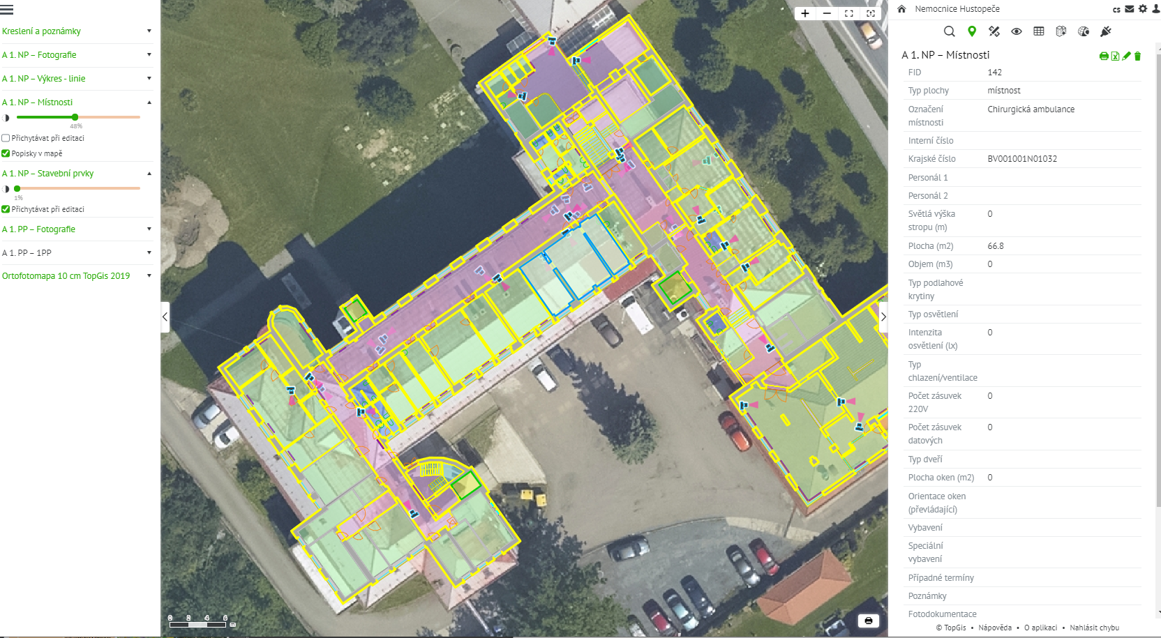
Budovy nemocnic, škol, ale třeba i krajských úřadů v Česku jsou v provozu často desítky let. Za tu dobu některé z nich doznaly řady změn a stavebních úprav, k nimž ale chybí správně vedená dokumentace, což správcům těchto areálů komplikuje údržbu i případné rekonstrukce. To je případ i hustopečské nemocnice, u které si Jihomoravský kraj nechal v letošním roce zpracovat komplexní […]
The post Starým budovám v majetcích měst a krajů často chybí přesná dokumentace. Nemocnici v Hustopečích pomohl komplexní pasport (TZ) appeared first on GISportal.cz.
Doctoral Position in Geoinformatics / Cartography at ETH Zurich
22.10.2020 9:26 The Institute of Cartography and Geoinformation at ETH Zurich is searching for a highly motivated doctoral student for the interdisciplinary project EMPHASES. The research topic will focus on the extraction and vectorization of features from historical maps by utilizing/improving Deep Learning/Computer Vision techniques. Detailed information can be found at https://jobs.ethz.ch/job/view/JOPG_ethz_FmFxlyrC4uEwKRVEaR Please, forward the offer to suitable […]Kratos Introduces OpenSpace™ Virtual Network Functions for Earth Observation Satellite Missions
22.10.2020 9:00 GISCafe.com Webcasts-Webinars SAN DIEGO, Oct. 20, 2020 (GLOBE NEWSWIRE) -- Kratos Defense & Security Solutions, Inc. (Nasdaq: KTOS), a leading National Security Solutions …MGISS Helps Northumbrian Water Mitigate Risk from Trees
22.10.2020 9:00 GISCafe.com Webcasts-Webinars Liverpool, UK, 20 October 2020 – Northumbrian Water, UK, is using satellite positioning and mobile mapping technology to manage safety risks …Acer představil nové modely podnikových notebooků TravelMate s matným displejem
22.10.2020 5:00 GeoBusinessTravelMate je oblíbená řada firemních notebooků značky Acer a současnou řadu rozšiřují tři nové modely využívající nejnovější procesory Intel Core 11. generace s grafikou Iris X a dedikovanými grafikami až NVIDIA GeForce MX350. První z nových modelů se jmenuje TravelMate Spin P4, což je konvertibilní notebook s dotykovou obrazovkou. TravelMate P4 je notebook pro ty, […]
The post Acer představil nové modely podnikových notebooků TravelMate s matným displejem appeared first on GeoBusiness.
ZRUŠENO - Zkoušky odborné způsobilosti k projektování pozemkových úprav
22.10.2020 0:00 Státní pozemkový úřadBentley Systems Announces Winners of Year in Infrastructure 2020 Awards
21.10.2020 23:38 GISCafe.com Webcasts-Webinars EXTON, Pa. — (BUSINESS WIRE) — October 21, 2020 —Bentley Systems, Incorporated, (Nasdaq: BSY), the infrastructure engineering …
VISTA Drone by Door Robotics Takes Flight on Kickstarter With a Fully Integrated 360-degree Camera
21.10.2020 23:38 GISCafe.com Webcasts-Webinars VISTA Drone is raising the standard with autonomous navigation and "invisible drone" capability providing the perfect shot, every time.COLLEGE PARK, …
GfK releases updated maps for all European countries
21.10.2020 21:20 GISCafe.com Webcasts-Webinars Bruchsal, Germany, October 21, 2020 – GfK has released its Europe Map Edition 2020/2021, which includes thousands of changes to Europe’s …Další miliarda na vznik a rozvoj digitálních technických map
21.10.2020 21:05 ZeměměřičAgentura pro podnikání a inovace, zprostředkující subjekt Operačního programu Podnikání a inovace pro konkurenceschopnost (OP PIK), zahájila 17. října 2020 příjem žádostí o dotace ve „Výzvě III programu podpory Vysokorychlostní internet“. Výzva je zaměřena na vznik a rozvoj digitálních technických map veřejnoprávních subjektů. O finanční podporu mohou žádat veřejnoprávní subjekty, které vlastní či spravují liniové stavby státu. Žadatelé mohou získat na jeden […]
The post Další miliarda na vznik a rozvoj digitálních technických map appeared first on Zeměměřič.
GHGSat Launches Pulse - a free and unique high-resolution methane map
21.10.2020 18:27 GISCafe.com Webcasts-Webinars MONTREAL, Oct. 21, 2020 — (PRNewswire) — GHGSat, the global leader in high-resolution greenhouse gas monitoring from space, today …Bentley Systems Announces Winners of Year in Infrastructure 2020 Awards
21.10.2020 17:40 Bentley SystemsEXTON, Pa. – October 21, 2020 – Bentley Systems, Incorporated, (Nasdaq: BSY), the infrastructure engineering software company, has announced the winners of the Year in Infrastructure 2020 Awards. The annual awards program honors the extraordinary work of Bentley users advancing design, construction, and operations of infrastructure throughout the world.
Sixteen independent jury panels selected the 57 finalists from over 400 nominations submitted by more than 330 organizations from more than 60 countries.
Bentley Systems acknowledged 19 Year in Infrastructure 2020 Awards winners and 14 Special Recognition awardees on October 21 during the Year in Infrastructure 2020 Conference, held virtually for the first time. To see the Year in Infrastructure 2020 Awards finalists present their projects, click here.
The Year in Infrastructure 2020 Special Recognition awardees are:
Advancing Project and Asset Longevity
HDR
Marc Basnight Bridge
Dare County, North Carolina, United States
Advancing Bridge Asset Performance Modeling
Ulsan National Institute of Science and Technology (UNIST)
A Smartwatch on the Bridge
Ulsan, Ulju-gun, South Korea
Advancing Industrial Asset Performance Modeling
The Institute of Engineering and Ocean Technology/Oil and Natural Gas Corporation Limited
Challenges in Addressing Life Extension of Ageing Platforms in Western Offshore of India
Mumbai, India
Comprehensiveness in Industrial Digital Twins
Volgogradnefteproekt, LLC
Ethane-Containing Gas Processing Complex Construction Support
Ust-Luga, St. Petersburg, Russia
Comprehensiveness in Transportation Digital Twins
PT. WASKITA Karya (Persero) Tbk
Railway Facility for Manggarai to Jatinegara: Package A - Phase II ( Main Line II )
South Jakarta, Jakarta, Indonesia
Comprehensiveness in Urban Digital Twins
JSTI Group Co., Ltd.
Hengjiang Avenue Rapid Transformation Project
Nanjing, Jiangsu, China
Comprehensiveness in a Connected Data Environment
Roads & Transport Authority (RTA)
Collaborative Information System Implementation - Whole Lifecycle Common Data Environment
Dubai, United Arab Emirates
Advancing Virtualization through Digital Twins
Network Rail
Overcoming Challenges Under COVID-19 Lockdown
Wales and Western Region, United Kingdom
Advancing Model-based Delivery through Digital Twins
NYS Department of Transportation
Model Based Contracting - NYS RT 28 over the Esopus
Mount Tremper, New York, United States
Advancing Mixed-Reality Workflows
Liaoning Water Conservancy and Hydropower Survey and Design Research Institute Co., Ltd.
Chaoyang Underground Pumping Station Project of the LXB Water Supply Project Phase II
Chaoyang, Liaoning, China
Advancing Sustainability Digital Twins
Shanghai Institute of Mechanical and Electrical Engineering Co., Ltd.
Shanghai Electric Environmental Protection Group Technology Renovation and Expansion Project for Nantong Thermoelectric Waste Incineration
Nantong, Jiangsu, China
Advancing Sustainable Architecture
Swatch Ltd., Shigeru Ban, Itten+Brechbühl AG
Swatch Headquarters
Biel, Bern, Switzerland
Advancing Sustainable Energy
Guangdong Hydropower Planning & Design Institute
Guangdong Yangjiang Pumped Storage Power Station
Yangjiang, Guangdong, China
Advancing Sustainable Water
Jacobs
San Jose Headworks
San Jose, California, United States
The winners of the Year in Infrastructure 2020 Awards for going digital advancements in infrastructure are:
4D Digital Construction
DPR Construction
2019 LSM DS Tech Upgrade
Durham, North Carolina, United States
Bridges
Chongqing Communications Planning, Survey & Design Institute Co., Ltd.,
Guizhou Communications Construction Group Co., Ltd.,
Guizhou Bridge Construction Group Co., Ltd.
Digital Design and Construction of Taihong Yangtze River Bridge
Chongqing, China
Buildings and Campuses
Voyants Solutions Private Limited
Bangladesh Regional Waterway Transport Project 1 – Shasanghat (New Dhaka) IWT Terminal
Dhaka-Shasanghat, Narayanganj, Chandpur, and Barisal; Bangladesh
Digital Cities
City of Helsinki
Digital City of Synergy
Helsinki, Finland
Geotechnical Engineering
Golder Associates Hong Kong Ltd.
Tuen Mun-Chek Lap Kok Link Tunnel, Southern Landfall
Hong Kong
Land and Site Development
AAEngineering Group
Dzhamgyr Mine - Project Implementation in Extreme Conditions
Talas Region, Kyrgyzstan
Manufacturing
MCC Capital Engineering & Research Incorporation Ltd.
BIM Technology-Based Construction of Digital Plant for Iron & Steel Base in Lingang, Laoting of HBIS Group Co., Ltd.
Tangshan, Hebei, China
Mining and Offshore Engineering
AAEngineering Group
Digital Twin of AKSU Plant: From Concept to Startup
Aksu, Akmola Region, Kazakhstan
Power Generation
Shanghai Institute of Mechanical and Electrical Engineering Co., Ltd.
Shanghai Electric Environmental Protection Group Technology Renovation and Expansion Project for Nantong Thermoelectric Waste Incineration
Nantong, Jiangsu, China
Project Delivery
Sweco
Sweco | Digitalisation with BIM
United Kingdom
Rail and Transit
POWERCHINA Huadong Engineering Corporation Limited
Innovative Application of Digital Engineering Technology in Shaoxing Rail and Transit Construction
Shaoxing, Zhejiang, China
Reality Modeling
Khatib & Alami
Geo-enabling Reality Model Tips and Tricks
Muscat, Oman
Road and Rail Asset Performance
Roads and Transport Authority (RTA)
Collaborative Information System Implementation - Whole Lifecycle Common Data Environment
Dubai, United Arab Emirates
Roads and Highways
Sichuan Road & Bridge (Group) Co., Ltd.
BIM Technology Application on Chengdu-Yibin Expressway
Chengdu, Sichuan, China
Structural Engineering
WSP
WSP Overcomes Complex Challenges with Bentley’s Technology to Deliver Principal Tower
London, England, United Kingdom
Utilities and Communications
Sterlite Power Transmission Limited
Sterlite BIM
Tripura, India
Utilities and Industrial Asset Performance
Shell’s QGC business
Evolution of Engineering Data, Documents and Information Management
Brisbane, Queensland, Australia
Water and Wastewater Treatment Plants
Hatch
Ashbridges Bay Treatment Plant Outfall
Toronto, Ontario, Canada
Water, Wastewater, and Stormwater Networks
DTK Hydronet Solutions
Digital Water Network Engineering & Asset Management of Dibrugarh Water Supply Project
Dibrugarh, Assam, India
All awards finalists and winners
Detailed descriptions of all nominated projects are in the print and digital versions of Bentley’s 2020 Infrastructure Yearbook, which will be published in early 2021. To review the past editions of this publication, access Bentley’s Infrastructure Yearbooks.
About Bentley Systems
Bentley Systems (Nasdaq: BSY) is the infrastructure engineering software company. We provide innovative software to advance the world’s infrastructure – sustaining both the global economy and environment. Our industry-leading software solutions are used by professionals, and organizations of every size, for the design, construction, and operations of roads and bridges, rail and transit, water and wastewater, public works and utilities, buildings and campuses, and industrial facilities. Our offerings include MicroStation-based applications for modeling and simulation, ProjectWise for project delivery, AssetWise for asset and network performance, and the iTwin platform for infrastructure digital twins. Bentley Systems employs more than 4,000 colleagues and generates annual revenues of more than $700 million, in 172 countries. www.bentley.com
© 2020 Bentley Systems, Incorporated. Bentley, the Bentley logo, AssetWise, iTwin, MicroStation, and ProjectWise are either registered or unregistered trademarks or service marks of Bentley Systems, Incorporated or one of its direct or indirect wholly owned subsidiaries. All other brands and product names are trademarks of their respective owners.
Konference GIS Esri v ČR zdarma pro studenty
21.10.2020 17:17 Katedra geoinformatiky UP OlomoucKonference uživatelů GIS Esri v ČR letos proběhne sice jenom virtuálně, ale má rozhodně nabitý a zajímavý program. Můžete se jí účastnit i vy, jako studenti katedry geoinformatiky. Při registraci stačí použít váš univerzitní email a odkázat referenci na katedru. Přihlaste se prosím nejpozději do pátku 30. 10. 2020. Víc informací naleznete https://www.arcdata.cz/zpravy-a-akce/akce/konference
The post Konference GIS Esri v ČR zdarma pro studenty appeared first on Katedra geoinformatiky.
Liaoning accelerates the construction of aviation fire emergency rescue system
21.10.2020 17:01 GISCafe.com Webcasts-Webinars SHENYANG, China, Oct. 21, 2020 — (PRNewswire) — At the 9th Shenyang Faku International Flight Conference, which opened on the 17th, a …FSF, International Relief Organizations Partner to Accelerate Drone Use in Humanitarian Missions
21.10.2020 17:01 GISCafe.com Webcasts-Webinars BRUSSELS, Oct. 21, 2020 — (PRNewswire) — Flight Safety Foundation announced a collaborative initiative to work with several …Teledyne Technologies Reports Third Quarter Results
21.10.2020 16:58 GISCafe.com Webcasts-Webinars THOUSAND OAKS, Calif. — (BUSINESS WIRE) — October 21, 2020 —Teledyne Technologies Incorporated (NYSE:TDY):
Sales of $749.0 …
Unmatched Accuracy, Confidence and Reliability: CoreLogic Launches New Automated Valuation Model
21.10.2020 16:58 GISCafe.com Webcasts-Webinars The new single model eliminates need for multiple AVMs and increases home valuation accuracyIRVINE, Calif. — (BUSINESS WIRE) — October …
Easy Aerial Integrates infiniDome GPSdome Technology to Ensure Continuous UAS Operations in GPS-Denied Environments
21.10.2020 16:58 GISCafe.com Webcasts-Webinars - GPS Signal Protection Vital to Ensure Safe Commercial and Defense BVLOS operations -BROOKLYN, N.Y. & CAESAREA, Israel — (BUSINESS WIRE) …
AUVSI and SAE International Announce Keynote Speakers for Business of Automated Mobility Forum
21.10.2020 16:58 GISCafe.com Webcasts-Webinars From drone delivery to driverless cars, industry experts to share insights on the opportunities and challenges of automated mobilityWARRENDALE, Pa., …
Quantum Spatial Completes Data Collection for NOAA's Largest Coastal Mapping Project
21.10.2020 16:57 GISCafe.com Webcasts-Webinars Unique Combination of Sensors Used to Gather High Resolution Topographic and Bathymetric Lidar Data Along 12,000 Square Miles of Eastern Seaboard and …New website puts climate in your hands
21.10.2020 16:55 ESA Observing the Earth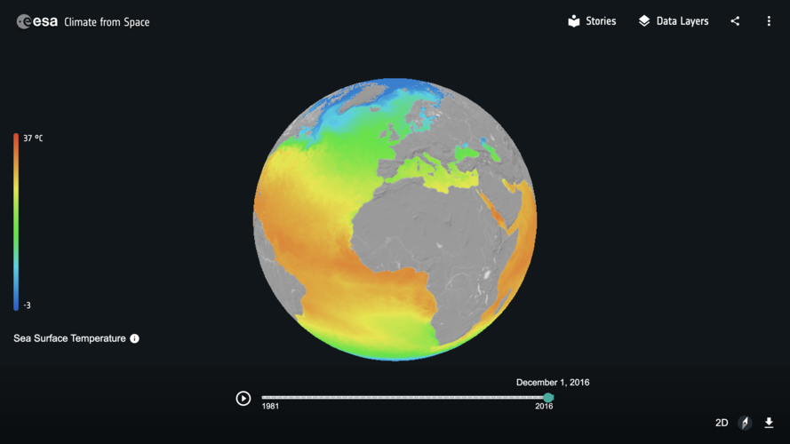
Witness the changing planet through the eye of Earth-orbiting satellites with ‘Climate from Space,’ a new interactive website developed by ESA.
Bentley Systems spouští iTwin Platform pro tzv. digitální dvojčata
21.10.2020 15:19 GeoBusinessFirma Bentley Systems, která v předchozích dnech uspořádala virtuální konference Year In Infrastructure, informovala o spuštění iTwin Platform. iTwin Platform navazuje na dosavadní pracovní postupy, spojené s digitálními dvojčaty, Design Review a Design Validation. Viceprezident pro iTwin Platform, Adam Klatzkin popisuje ve zprávě, co se povedlo vytvořit. Launching iTwin Platform This is a brand-new platform-as-a-service […]
The post Bentley Systems spouští iTwin Platform pro tzv. digitální dvojčata appeared first on GeoBusiness.