


![]()

zprávy
zdroje zpráv:Odborný referent v oddělení obnovy katastrálního operátu č. 3
22.10.2020 12:53 ČÚZK /Urady/Katastralni-urady/Katastralni-urady/Katastralni-urad-pro-Jihomoravsky-kraj/Uredni-deska/Oznameni-a-jina-uredni-sdeleni/Volna-mista/DMS/Odborny-referent-v-oddeleni-obnovy-katastralniho-oOdborný referent v oddělení obnovy katastrálního operátu č. 3
22.10.2020 12:53 ČÚZK - předpisy a opatření Katastrální úřad pro Jihomoravský kraj technická sekcevypisuje výběrové řízení na místo
Odborný referent v oddělení obnovy katastrálního operátu č. 3
Odborný referent v oddělení obnovy katastrálního operátu č. 3
22.10.2020 12:53 ČÚZK - volná místa Katastrální úřad pro Jihomoravský kraj technická sekce vypisuje výběrové řízení na místo Odborný referent v oddělení obnovy katastrálního operátu č. 3Přijetí krizových opatření
22.10.2020 12:48 ČÚZK - předpisy a opatření Katastrální úřad pro Královéhradecký kraj zveřejnil novou aktualitu:Přijetí krizových opatření:
v návaznosti na Usnesení vlády ČR ze dne 21. 10. 2020 č. 1080 o přijetí krizového opatření oznamuje úpravu úředních hodin na katastrálních pracovištích takto:
Hradec Králové, Náchod, Rychnov nad Kněžnou a Trutnov:
pondělí a středa od 8:00 - 13:00
Jičín:
pondělí 9:00 - 14:00
středa 10:00 - 15:00
Více podrobností v oznámení.
Přijetí krizových opatření
22.10.2020 12:48 ČÚZK - předpisy a opatření Český úřad zeměměřický a katastrální zveřejnil novou aktualitu: Katastrální úřad pro Královéhradecký krajv návaznosti na Usnesení vlády ČR ze dne 21. 10. 2020 č. 1080 o přijetí krizového opatření oznamuje:
Všechna katastrální pracoviště v územní působnosti Katastrálního úřadu pro Královéhradecký kraj mají nadále omezeny služby vyžadující přímý kontakt s veřejností.
Na Katastrálních pracovištích Hradec Králové, Náchod, Rychnov nad Kněžnou a Trutnov jsou úřední hodiny od 22. 10. 2020 stanoveny takto: pondělí a středa od 8:00 do 13:00, na Katastrálním pracovišti Jičín: pondělí od 9:00 do 14:00 a středa od 10:00 do 15:00.
Pro příjem podání a poskytování údajů se upřednostňuje písemný, elektronický či telefonický kontakt před osobním kontaktem ve všech případech, kdy je to možné.
Návrhy na vklad práv i ostatní podání je možné činit prostřednictvím provozovatele poštovních služeb nebo elektronicky (e-mailem nebo prostřednictvím datových schránek). Podrobnosti o elektronických podáních a parametrech přijímaných datových zpráv zde: https://www.cuzk.cz/Katastr-nemovitosti/Zapisy-do-KN/Informace-o-elektronickem-podani.aspx. Účastníci řízení o povolení vkladu budou v těchto případech vyzváni k úhradě správního poplatku, který lze uhradit převodem na účet.
Údaje katastru nemovitostí lze získat i prostřednictvím aplikace Nahlížení do katastru https://nahlizenidokn.cuzk.cz/, kde je možné prostřednictvím e-shopu získat i úplný výpis z katastru nemovitostí v elektronické podobě, prostřednictvím aplikace Dálkový přístup https://www.cuzk.cz/aplikace-dp pro registrované uživatele, nebo na kontaktních místech státní správy Czech POINT.
Ing. Jaroslav Bačina v. r.
ředitel
V Hradci Králové dne 22. 10. 2020
Přijetí krizových opatření
22.10.2020 12:48 ČÚZK /Urady/Katastralni-urady/Katastralni-urady/Katastralni-urad-pro-Kralovehradecky-kraj/O-uradu/Aktuality/Prijeti-krizovych-opatreniPřijetí krizových opatření
22.10.2020 12:48 ČÚZK - předpisy a opatření Katastrální úřad pro Královéhradecký kraj zveřejnil novou aktualitu:Přijetí krizových opatření:
v návaznosti na Usnesení vlády ČR ze dne 21. 10. 2020 č. 1080 o přijetí krizového opatření oznamuje úpravu úředních hodin na katastrálních pracovištích takto:
Hradec Králové, Náchod, Rychnov nad Kněžnou a Trutnov:
pondělí a středa od 8:00–13:00
Jičín:
pondělí 9:00–14:00
středa 10:00–15:00
Více podrobností v oznámení.
Přijetí krizových opatření
22.10.2020 12:48 ČÚZK - předpisy a opatření Český úřad zeměměřický a katastrální zveřejnil novou aktualitu: Katastrální úřad pro Královéhradecký krajv návaznosti na Usnesení vlády ČR ze dne 21. 10. 2020 č. 1080 o přijetí krizového opatření oznamuje:
Všechna katastrální pracoviště v územní působnosti Katastrálního úřadu pro Královéhradecký kraj mají nadále omezeny služby vyžadující přímý kontakt s veřejností.
Na Katastrálních pracovištích Hradec Králové, Náchod, Rychnov nad Kněžnou a Trutnov jsou úřední hodiny od 22. 10. 2020 stanoveny takto: pondělí a středa od 8:00 do 17:00, na Katastrálním pracovišti Jičín: pondělí od 9:00 do 14:00 a středa od 10:00 do 15:00.
Pro příjem podání a poskytování údajů se upřednostňuje písemný, elektronický či telefonický kontakt před osobním kontaktem ve všech případech, kdy je to možné.
Návrhy na vklad práv i ostatní podání je možné činit prostřednictvím provozovatele poštovních služeb nebo elektronicky (e-mailem nebo prostřednictvím datových schránek). Podrobnosti o elektronických podáních a parametrech přijímaných datových zpráv zde: https://www.cuzk.cz/Katastr-nemovitosti/Zapisy-do-KN/Informace-o-elektronickem-podani.aspx. Účastníci řízení o povolení vkladu budou v těchto případech vyzváni k úhradě správního poplatku, který lze uhradit převodem na účet.
Údaje katastru nemovitostí lze získat i prostřednictvím aplikace Nahlížení do katastru https://nahlizenidokn.cuzk.cz/, kde je možné prostřednictvím e-shopu získat i úplný výpis z katastru nemovitostí v elektronické podobě, prostřednictvím aplikace Dálkový přístup https://www.cuzk.cz/aplikace-dp pro registrované uživatele, nebo na kontaktních místech státní správy Czech POINT.
Ing. Jaroslav Bačina v. r.
ředitel
V Hradci Králové dne 22. 10. 2020
Přijetí krizových opatření
22.10.2020 12:48 ČÚZK - předpisy a opatření Katastrální úřad pro Královéhradecký kraj zveřejnil novou aktualitu:V návaznosti na Usnesení vlády ČR ze dne 21. 10. 2020 č. 1080 o přijetí krizového opatření oznamuje úpravu úředních hodin na katastrálních pracovištích takto:
Hradec Králové, Náchod, Rychnov nad Kněžnou a Trutnov: pondělí a středa od 8:00 - 13:00
Jičín: pondělí 9:00 - 14:00 a středa 10:00 - 15:00
Více podrobností v oznámení.
rada / odborný rada – operátor informačních a komunikačních technologií v oddělení podpory ICT
22.10.2020 12:48 ČÚZK - volná místa Katastrální úřad pro Liberecký kraj vypisuje výběrové řízení na místo rada / odborný rada – operátor informačních a komunikačních technologií v oddělení podpory ICTodborný referent v oddělení právních vztahů k nemovitostem
22.10.2020 12:48 ČÚZK - předpisy a opatření Katastrální úřad pro Liberecký kraj - Katastrální pracoviště Liberecvypisuje výběrové řízení na místo
odborný referent v oddělení právních vztahů k nemovitostem
rada / odborný rada – operátor informačních a komunikačních technologií v oddělení podpory ICT
22.10.2020 12:48 ČÚZK /Urady/Katastralni-urady/Katastralni-urady/Katastralni-urad-pro-Liberecky-kraj/Uredni-deska/Oznameni-a-jina-uredni-sdeleni/Volna-mista/odborny-referent-v-oddeleni-pravnich-vztahu-k-(1)rada / odborný rada – operátor informačních a komunikačních technologií v oddělení podpory ICT
22.10.2020 12:48 ČÚZK - předpisy a opatření Katastrální úřad pro Liberecký krajvypisuje výběrové řízení na místo
rada / odborný rada – operátor informačních a komunikačních technologií v oddělení podpory ICT
rada / odborný rada – operátor informačních a komunikačních technologií v oddělení podpory ICT
22.10.2020 12:48 ČÚZK - předpisy a opatření Katastrální úřad pro Liberecký kraj - Katastrální pracoviště Liberecvypisuje výběrové řízení na místo
rada / odborný rada – operátor informačních a komunikačních technologií v oddělení podpory ICT
rada / odborný rada – operátor informačních a komunikačních technologií v oddělení podpory ICT
22.10.2020 12:48 ČÚZK - volná místa Katastrální úřad pro Liberecký kraj - Katastrální pracoviště Liberec vypisuje výběrové řízení na místo rada / odborný rada – operátor informačních a komunikačních technologií v oddělení podpory ICTrada / odborný rada v oddělení právních vztahů k nemovitostem
22.10.2020 12:38 ČÚZK /Urady/Katastralni-urady/Katastralni-urady/Katastralni-urad-pro-Liberecky-kraj/Uredni-deska/Oznameni-a-jina-uredni-sdeleni/Volna-mista/rada-odborny-rada-v-oddeleni-pravnich-vztahurada / odborný rada v oddělení právních vztahů k nemovitostem
22.10.2020 12:38 ČÚZK - předpisy a opatření Katastrální úřad pro Liberecký kraj - Katastrální pracoviště Liberecvypisuje výběrové řízení na místo
rada / odborný rada v oddělení právních vztahů k nemovitostem
rada / odborný rada v oddělení právních vztahů k nemovitostem
22.10.2020 12:38 ČÚZK - volná místa Katastrální úřad pro Liberecký kraj - Katastrální pracoviště Liberec vypisuje výběrové řízení na místo rada / odborný rada v oddělení právních vztahů k nemovitostemrada / odborný rada v oddělení právních vztahů
22.10.2020 12:38 ČÚZK /Urady/Katastralni-urady/Katastralni-urady/Katastralni-urad-pro-Liberecky-kraj/Uredni-deska/Oznameni-a-jina-uredni-sdeleni/Volna-mista/rada-odborny-rada-v-oddeleni-pravnich-vztahuSpace for climate
22.10.2020 11:30 ESA Observing the Earth Video:
00:01:16
Video:
00:01:16
The scientific evidence of global climate change is irrefutable. The consequences of a warming climate are far-reaching – affecting fresh water resources, global food production, sea level and triggering an increase in extreme-weather events.
In order to tackle climate change, scientists and governments need reliable data in order to understand how our planet is changing. ESA is a world-leader in Earth observation and remains dedicated to developing cutting-edge spaceborne technology to further understand the planet, improve daily lives, support effect policy-making for a more sustainable future, and benefit businesses and the economy.
Learn more about ESA’s role in understanding climate change here.
Space for climate
22.10.2020 11:30 ESA Observing the Earth Video:
00:01:16
Video:
00:01:16
The scientific evidence of global climate change is irrefutable. The consequences of a warming climate are far-reaching – affecting fresh water resources, global food production, sea level and triggering an increase in extreme-weather events.
In order to tackle climate change, scientists and governments need reliable data in order to understand how our planet is changing. ESA is a world-leader in Earth observation and remains dedicated to developing cutting-edge spaceborne technology to further understand the planet, improve daily lives, support effect policy-making for a more sustainable future, and benefit businesses and the economy.
Learn more about ESA’s role in understanding climate change here.
provoz_ZU
22.10.2020 11:06 Zeměměřický úřad Zeměměřický úřad zveřejnil novou aktualitu: Informace o provozu ZÚNa základě Usnesení Vlády České republiky ze dne 21. října 2020 č. 1080, o přijetí krizového opatření, je nucen Zeměměřický úřad, omezit provoz vyplývající z nouzového stavu, a to ode dne 22. října 2020 od 06:00 hod. do dne 3. listopadu 2020 do 23:59 hod. Badatelna Ústředního archivu zeměměřictví a katastru a prodejna map jsou převedeny do režimu s minimálním stykem s veřejností a tedy bez návštěv. Je nutné upřednostnit jiné způsoby komunikace, např. e-mail, datová zpráva, popř. telefon. Služby Geoportálu ČÚZK včetně CZEPOS a dalších geodetických aplikací pro potřeby zeměměřičů jsou provozovány bez omezení.
provoz_ZU
22.10.2020 11:06 ČÚZK - předpisy a opatření Zeměměřický úřad zveřejnil novou aktualitu: Informace o provozu ZÚNa základě Usnesení Vlády České republiky ze dne 21. října 2020 č. 1080, o přijetí krizového opatření, je nucen Zeměměřický úřad, omezit provoz vyplývající z nouzového stavu, a to ode dne 22. října 2020 od 06:00 hod. do dne 3. listopadu 2020 do 23:59 hod. Badatelna Ústředního archivu zeměměřictví a katastru a prodejna map jsou převedeny do režimu s minimálním stykem s veřejností a tedy bez návštěv. Je nutné upřednostnit jiné způsoby komunikace, např. e-mail, datová zpráva, popř. telefon. Služby Geoportálu ČÚZK včetně CZEPOS a dalších geodetických aplikací pro potřeby zeměměřičů jsou provozovány bez omezení.
Volná místa - do 08.1.2021
22.10.2020 10:09 ČÚZK - předpisy a opatření Katastrální úřad pro hlavní město Prahu - Katastrální pracoviště Praha zveřejnil novou aktualitu: Ředitel úřadu vyhlašuje výběrové řízení na služební místo:rada/odborný rada – vedoucí oddělení informací z KN a veřejných knih
Volná místa - do 11.11.2020
22.10.2020 10:09 ČÚZK - předpisy a opatření Katastrální úřad pro hlavní město Prahu - Katastrální pracoviště Praha zveřejnil novou aktualitu: Ředitel úřadu vyhlašuje výběrové řízení na služební místo:odborný referent/vrchní referent – návrh zápisu v katastru
Volná místa - do 11.11.2020
22.10.2020 10:09 ČÚZK /Urady/Katastralni-urady/Katastralni-urady/Katastralni-urad-pro-hlavni-mesto-Prahu/O-uradu/Aktuality/Volna-mista-do-11-11-2020Volná místa - do 08.1.2021
22.10.2020 10:09 ČÚZK /Urady/Katastralni-urady/Katastralni-urady/Katastralni-urad-pro-hlavni-mesto-Prahu/O-uradu/Aktuality/Volna-mista-do-11-11-2020odborný referent/vrchní referent – návrh zápisu v katastru
22.10.2020 9:51 ČÚZK - volná místa Katastrální úřad pro hlavní město Prahu Katastrální pracoviště Praha vypisuje výběrové řízení na místo odborný referent/vrchní referent – návrh zápisu v katastruodborný referent/vrchní referent – návrh zápisu v katastru
22.10.2020 9:51 ČÚZK - předpisy a opatření Katastrální úřad pro hlavní město Prahu Katastrální pracoviště Prahavypisuje výběrové řízení na místo
odborný referent/vrchní referent – návrh zápisu v katastru
Starým budovám v majetcích měst a krajů často chybí přesná dokumentace. Nemocnici v Hustopečích pomohl komplexní pasport (TZ)
22.10.2020 9:35 GISportal.cz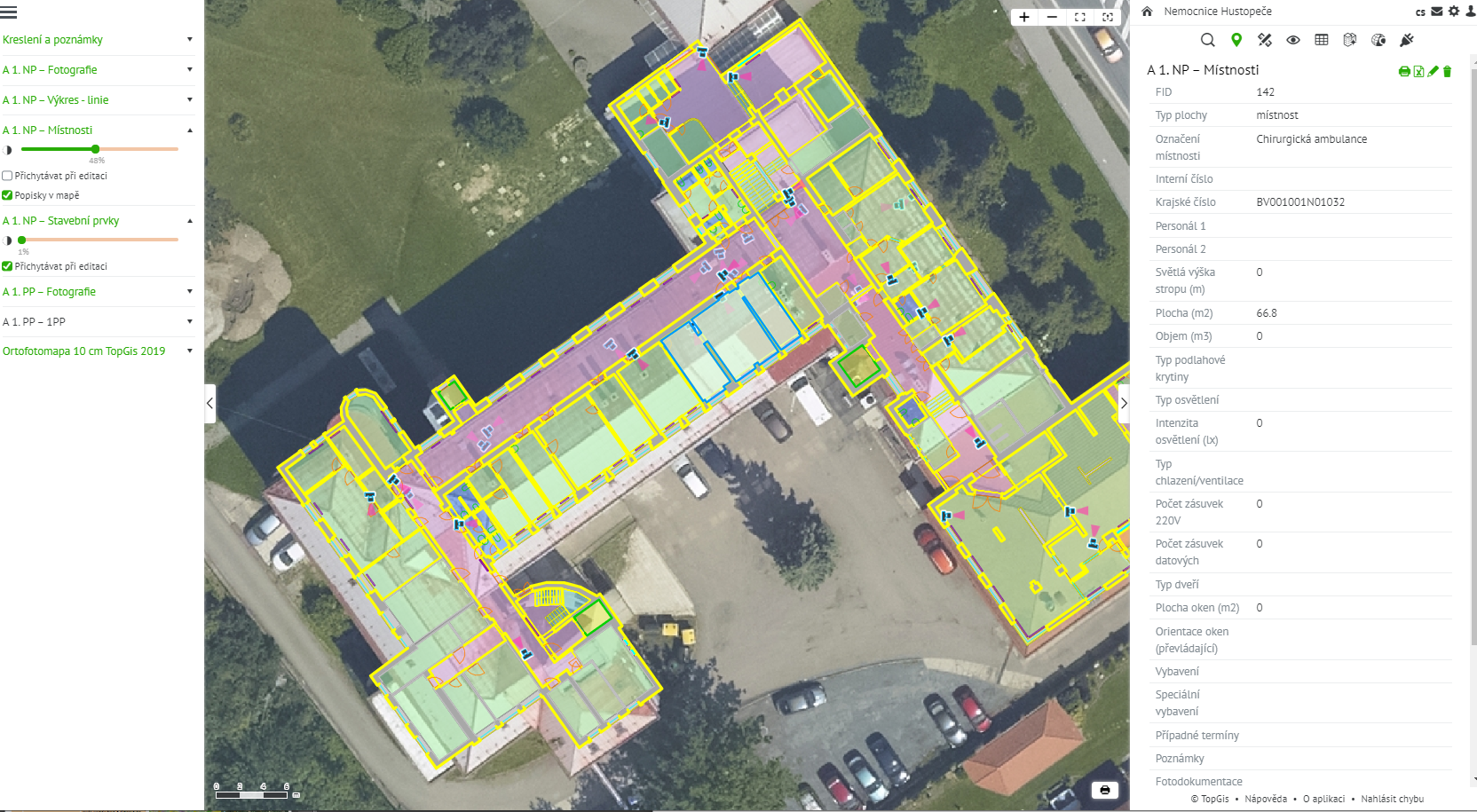
Budovy nemocnic, škol, ale třeba i krajských úřadů v Česku jsou v provozu často desítky let. Za tu dobu některé z nich doznaly řady změn a stavebních úprav, k nimž ale chybí správně vedená dokumentace, což správcům těchto areálů komplikuje údržbu i případné rekonstrukce. To je případ i hustopečské nemocnice, u které si Jihomoravský kraj nechal v letošním roce zpracovat komplexní […]
The post Starým budovám v majetcích měst a krajů často chybí přesná dokumentace. Nemocnici v Hustopečích pomohl komplexní pasport (TZ) appeared first on GISportal.cz.
Doctoral Position in Geoinformatics / Cartography at ETH Zurich
22.10.2020 9:26 The Institute of Cartography and Geoinformation at ETH Zurich is searching for a highly motivated doctoral student for the interdisciplinary project EMPHASES. The research topic will focus on the extraction and vectorization of features from historical maps by utilizing/improving Deep Learning/Computer Vision techniques. Detailed information can be found at https://jobs.ethz.ch/job/view/JOPG_ethz_FmFxlyrC4uEwKRVEaR Please, forward the offer to suitable […]Kratos Introduces OpenSpace™ Virtual Network Functions for Earth Observation Satellite Missions
22.10.2020 9:00 GISCafe.com Webcasts-Webinars SAN DIEGO, Oct. 20, 2020 (GLOBE NEWSWIRE) -- Kratos Defense & Security Solutions, Inc. (Nasdaq: KTOS), a leading National Security Solutions …MGISS Helps Northumbrian Water Mitigate Risk from Trees
22.10.2020 9:00 GISCafe.com Webcasts-Webinars Liverpool, UK, 20 October 2020 – Northumbrian Water, UK, is using satellite positioning and mobile mapping technology to manage safety risks …Acer představil nové modely podnikových notebooků TravelMate s matným displejem
22.10.2020 5:00 GeoBusinessTravelMate je oblíbená řada firemních notebooků značky Acer a současnou řadu rozšiřují tři nové modely využívající nejnovější procesory Intel Core 11. generace s grafikou Iris X a dedikovanými grafikami až NVIDIA GeForce MX350. První z nových modelů se jmenuje TravelMate Spin P4, což je konvertibilní notebook s dotykovou obrazovkou. TravelMate P4 je notebook pro ty, […]
The post Acer představil nové modely podnikových notebooků TravelMate s matným displejem appeared first on GeoBusiness.
ZRUŠENO - Zkoušky odborné způsobilosti k projektování pozemkových úprav
22.10.2020 0:00 Státní pozemkový úřadBentley Systems Announces Winners of Year in Infrastructure 2020 Awards
21.10.2020 23:38 GISCafe.com Webcasts-Webinars EXTON, Pa. — (BUSINESS WIRE) — October 21, 2020 —Bentley Systems, Incorporated, (Nasdaq: BSY), the infrastructure engineering …
VISTA Drone by Door Robotics Takes Flight on Kickstarter With a Fully Integrated 360-degree Camera
21.10.2020 23:38 GISCafe.com Webcasts-Webinars VISTA Drone is raising the standard with autonomous navigation and "invisible drone" capability providing the perfect shot, every time.COLLEGE PARK, …
GfK releases updated maps for all European countries
21.10.2020 21:20 GISCafe.com Webcasts-Webinars Bruchsal, Germany, October 21, 2020 – GfK has released its Europe Map Edition 2020/2021, which includes thousands of changes to Europe’s …Další miliarda na vznik a rozvoj digitálních technických map
21.10.2020 21:05 ZeměměřičAgentura pro podnikání a inovace, zprostředkující subjekt Operačního programu Podnikání a inovace pro konkurenceschopnost (OP PIK), zahájila 17. října 2020 příjem žádostí o dotace ve „Výzvě III programu podpory Vysokorychlostní internet“. Výzva je zaměřena na vznik a rozvoj digitálních technických map veřejnoprávních subjektů. O finanční podporu mohou žádat veřejnoprávní subjekty, které vlastní či spravují liniové stavby státu. Žadatelé mohou získat na jeden […]
The post Další miliarda na vznik a rozvoj digitálních technických map appeared first on Zeměměřič.
GHGSat Launches Pulse - a free and unique high-resolution methane map
21.10.2020 18:27 GISCafe.com Webcasts-Webinars MONTREAL, Oct. 21, 2020 — (PRNewswire) — GHGSat, the global leader in high-resolution greenhouse gas monitoring from space, today …Bentley Systems Announces Winners of Year in Infrastructure 2020 Awards
21.10.2020 17:40 Bentley SystemsEXTON, Pa. – October 21, 2020 – Bentley Systems, Incorporated, (Nasdaq: BSY), the infrastructure engineering software company, has announced the winners of the Year in Infrastructure 2020 Awards. The annual awards program honors the extraordinary work of Bentley users advancing design, construction, and operations of infrastructure throughout the world.
Sixteen independent jury panels selected the 57 finalists from over 400 nominations submitted by more than 330 organizations from more than 60 countries.
Bentley Systems acknowledged 19 Year in Infrastructure 2020 Awards winners and 14 Special Recognition awardees on October 21 during the Year in Infrastructure 2020 Conference, held virtually for the first time. To see the Year in Infrastructure 2020 Awards finalists present their projects, click here.
The Year in Infrastructure 2020 Special Recognition awardees are:
Advancing Project and Asset Longevity
HDR
Marc Basnight Bridge
Dare County, North Carolina, United States
Advancing Bridge Asset Performance Modeling
Ulsan National Institute of Science and Technology (UNIST)
A Smartwatch on the Bridge
Ulsan, Ulju-gun, South Korea
Advancing Industrial Asset Performance Modeling
The Institute of Engineering and Ocean Technology/Oil and Natural Gas Corporation Limited
Challenges in Addressing Life Extension of Ageing Platforms in Western Offshore of India
Mumbai, India
Comprehensiveness in Industrial Digital Twins
Volgogradnefteproekt, LLC
Ethane-Containing Gas Processing Complex Construction Support
Ust-Luga, St. Petersburg, Russia
Comprehensiveness in Transportation Digital Twins
PT. WASKITA Karya (Persero) Tbk
Railway Facility for Manggarai to Jatinegara: Package A - Phase II ( Main Line II )
South Jakarta, Jakarta, Indonesia
Comprehensiveness in Urban Digital Twins
JSTI Group Co., Ltd.
Hengjiang Avenue Rapid Transformation Project
Nanjing, Jiangsu, China
Comprehensiveness in a Connected Data Environment
Roads & Transport Authority (RTA)
Collaborative Information System Implementation - Whole Lifecycle Common Data Environment
Dubai, United Arab Emirates
Advancing Virtualization through Digital Twins
Network Rail
Overcoming Challenges Under COVID-19 Lockdown
Wales and Western Region, United Kingdom
Advancing Model-based Delivery through Digital Twins
NYS Department of Transportation
Model Based Contracting - NYS RT 28 over the Esopus
Mount Tremper, New York, United States
Advancing Mixed-Reality Workflows
Liaoning Water Conservancy and Hydropower Survey and Design Research Institute Co., Ltd.
Chaoyang Underground Pumping Station Project of the LXB Water Supply Project Phase II
Chaoyang, Liaoning, China
Advancing Sustainability Digital Twins
Shanghai Institute of Mechanical and Electrical Engineering Co., Ltd.
Shanghai Electric Environmental Protection Group Technology Renovation and Expansion Project for Nantong Thermoelectric Waste Incineration
Nantong, Jiangsu, China
Advancing Sustainable Architecture
Swatch Ltd., Shigeru Ban, Itten+Brechbühl AG
Swatch Headquarters
Biel, Bern, Switzerland
Advancing Sustainable Energy
Guangdong Hydropower Planning & Design Institute
Guangdong Yangjiang Pumped Storage Power Station
Yangjiang, Guangdong, China
Advancing Sustainable Water
Jacobs
San Jose Headworks
San Jose, California, United States
The winners of the Year in Infrastructure 2020 Awards for going digital advancements in infrastructure are:
4D Digital Construction
DPR Construction
2019 LSM DS Tech Upgrade
Durham, North Carolina, United States
Bridges
Chongqing Communications Planning, Survey & Design Institute Co., Ltd.,
Guizhou Communications Construction Group Co., Ltd.,
Guizhou Bridge Construction Group Co., Ltd.
Digital Design and Construction of Taihong Yangtze River Bridge
Chongqing, China
Buildings and Campuses
Voyants Solutions Private Limited
Bangladesh Regional Waterway Transport Project 1 – Shasanghat (New Dhaka) IWT Terminal
Dhaka-Shasanghat, Narayanganj, Chandpur, and Barisal; Bangladesh
Digital Cities
City of Helsinki
Digital City of Synergy
Helsinki, Finland
Geotechnical Engineering
Golder Associates Hong Kong Ltd.
Tuen Mun-Chek Lap Kok Link Tunnel, Southern Landfall
Hong Kong
Land and Site Development
AAEngineering Group
Dzhamgyr Mine - Project Implementation in Extreme Conditions
Talas Region, Kyrgyzstan
Manufacturing
MCC Capital Engineering & Research Incorporation Ltd.
BIM Technology-Based Construction of Digital Plant for Iron & Steel Base in Lingang, Laoting of HBIS Group Co., Ltd.
Tangshan, Hebei, China
Mining and Offshore Engineering
AAEngineering Group
Digital Twin of AKSU Plant: From Concept to Startup
Aksu, Akmola Region, Kazakhstan
Power Generation
Shanghai Institute of Mechanical and Electrical Engineering Co., Ltd.
Shanghai Electric Environmental Protection Group Technology Renovation and Expansion Project for Nantong Thermoelectric Waste Incineration
Nantong, Jiangsu, China
Project Delivery
Sweco
Sweco | Digitalisation with BIM
United Kingdom
Rail and Transit
POWERCHINA Huadong Engineering Corporation Limited
Innovative Application of Digital Engineering Technology in Shaoxing Rail and Transit Construction
Shaoxing, Zhejiang, China
Reality Modeling
Khatib & Alami
Geo-enabling Reality Model Tips and Tricks
Muscat, Oman
Road and Rail Asset Performance
Roads and Transport Authority (RTA)
Collaborative Information System Implementation - Whole Lifecycle Common Data Environment
Dubai, United Arab Emirates
Roads and Highways
Sichuan Road & Bridge (Group) Co., Ltd.
BIM Technology Application on Chengdu-Yibin Expressway
Chengdu, Sichuan, China
Structural Engineering
WSP
WSP Overcomes Complex Challenges with Bentley’s Technology to Deliver Principal Tower
London, England, United Kingdom
Utilities and Communications
Sterlite Power Transmission Limited
Sterlite BIM
Tripura, India
Utilities and Industrial Asset Performance
Shell’s QGC business
Evolution of Engineering Data, Documents and Information Management
Brisbane, Queensland, Australia
Water and Wastewater Treatment Plants
Hatch
Ashbridges Bay Treatment Plant Outfall
Toronto, Ontario, Canada
Water, Wastewater, and Stormwater Networks
DTK Hydronet Solutions
Digital Water Network Engineering & Asset Management of Dibrugarh Water Supply Project
Dibrugarh, Assam, India
All awards finalists and winners
Detailed descriptions of all nominated projects are in the print and digital versions of Bentley’s 2020 Infrastructure Yearbook, which will be published in early 2021. To review the past editions of this publication, access Bentley’s Infrastructure Yearbooks.
About Bentley Systems
Bentley Systems (Nasdaq: BSY) is the infrastructure engineering software company. We provide innovative software to advance the world’s infrastructure – sustaining both the global economy and environment. Our industry-leading software solutions are used by professionals, and organizations of every size, for the design, construction, and operations of roads and bridges, rail and transit, water and wastewater, public works and utilities, buildings and campuses, and industrial facilities. Our offerings include MicroStation-based applications for modeling and simulation, ProjectWise for project delivery, AssetWise for asset and network performance, and the iTwin platform for infrastructure digital twins. Bentley Systems employs more than 4,000 colleagues and generates annual revenues of more than $700 million, in 172 countries. www.bentley.com
© 2020 Bentley Systems, Incorporated. Bentley, the Bentley logo, AssetWise, iTwin, MicroStation, and ProjectWise are either registered or unregistered trademarks or service marks of Bentley Systems, Incorporated or one of its direct or indirect wholly owned subsidiaries. All other brands and product names are trademarks of their respective owners.
Konference GIS Esri v ČR zdarma pro studenty
21.10.2020 17:17 Katedra geoinformatiky UP OlomoucKonference uživatelů GIS Esri v ČR letos proběhne sice jenom virtuálně, ale má rozhodně nabitý a zajímavý program. Můžete se jí účastnit i vy, jako studenti katedry geoinformatiky. Při registraci stačí použít váš univerzitní email a odkázat referenci na katedru. Přihlaste se prosím nejpozději do pátku 30. 10. 2020. Víc informací naleznete https://www.arcdata.cz/zpravy-a-akce/akce/konference
The post Konference GIS Esri v ČR zdarma pro studenty appeared first on Katedra geoinformatiky.
Liaoning accelerates the construction of aviation fire emergency rescue system
21.10.2020 17:01 GISCafe.com Webcasts-Webinars SHENYANG, China, Oct. 21, 2020 — (PRNewswire) — At the 9th Shenyang Faku International Flight Conference, which opened on the 17th, a …FSF, International Relief Organizations Partner to Accelerate Drone Use in Humanitarian Missions
21.10.2020 17:01 GISCafe.com Webcasts-Webinars BRUSSELS, Oct. 21, 2020 — (PRNewswire) — Flight Safety Foundation announced a collaborative initiative to work with several …Teledyne Technologies Reports Third Quarter Results
21.10.2020 16:58 GISCafe.com Webcasts-Webinars THOUSAND OAKS, Calif. — (BUSINESS WIRE) — October 21, 2020 —Teledyne Technologies Incorporated (NYSE:TDY):
Sales of $749.0 …
Unmatched Accuracy, Confidence and Reliability: CoreLogic Launches New Automated Valuation Model
21.10.2020 16:58 GISCafe.com Webcasts-Webinars The new single model eliminates need for multiple AVMs and increases home valuation accuracyIRVINE, Calif. — (BUSINESS WIRE) — October …
Easy Aerial Integrates infiniDome GPSdome Technology to Ensure Continuous UAS Operations in GPS-Denied Environments
21.10.2020 16:58 GISCafe.com Webcasts-Webinars - GPS Signal Protection Vital to Ensure Safe Commercial and Defense BVLOS operations -BROOKLYN, N.Y. & CAESAREA, Israel — (BUSINESS WIRE) …
AUVSI and SAE International Announce Keynote Speakers for Business of Automated Mobility Forum
21.10.2020 16:58 GISCafe.com Webcasts-Webinars From drone delivery to driverless cars, industry experts to share insights on the opportunities and challenges of automated mobilityWARRENDALE, Pa., …
Quantum Spatial Completes Data Collection for NOAA's Largest Coastal Mapping Project
21.10.2020 16:57 GISCafe.com Webcasts-Webinars Unique Combination of Sensors Used to Gather High Resolution Topographic and Bathymetric Lidar Data Along 12,000 Square Miles of Eastern Seaboard and …New website puts climate in your hands
21.10.2020 16:55 ESA Observing the Earth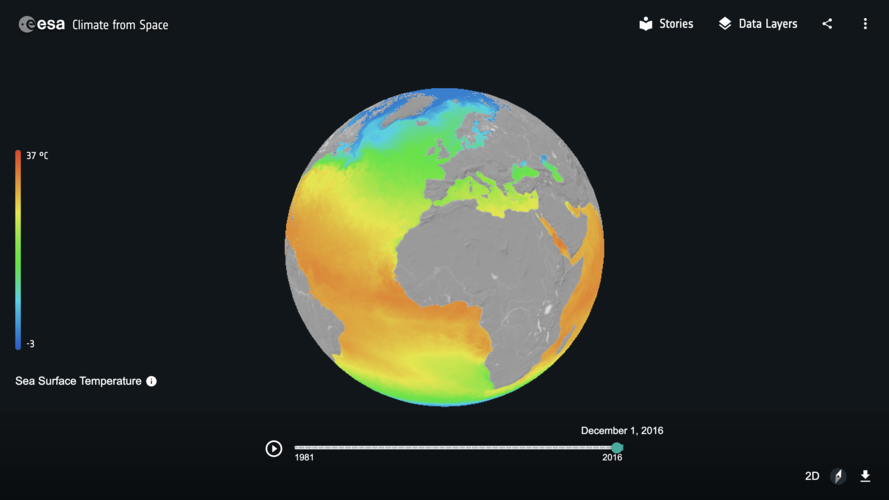
Witness the changing planet through the eye of Earth-orbiting satellites with ‘Climate from Space,’ a new interactive website developed by ESA.
Bentley Systems spouští iTwin Platform pro tzv. digitální dvojčata
21.10.2020 15:19 GeoBusinessFirma Bentley Systems, která v předchozích dnech uspořádala virtuální konference Year In Infrastructure, informovala o spuštění iTwin Platform. iTwin Platform navazuje na dosavadní pracovní postupy, spojené s digitálními dvojčaty, Design Review a Design Validation. Viceprezident pro iTwin Platform, Adam Klatzkin popisuje ve zprávě, co se povedlo vytvořit. Launching iTwin Platform This is a brand-new platform-as-a-service […]
The post Bentley Systems spouští iTwin Platform pro tzv. digitální dvojčata appeared first on GeoBusiness.
Verze 14.75 reaguje na změny ČÚZK
21.10.2020 15:17 GEPROPublikovali jsme verze 14.75 našich produktů MISYS, MISYS-WEB – licenční server, KOKEŠ, Geoportál GEPRO i PROLAND.… >>
GSA vydává technologickou zprávu o vývoji GNSS
21.10.2020 14:42 GeoBusinessEvropská agentura pro GNSS (GSA) vydala svoji třetí GNSS Technology Report 2020 – zpráva obsahuje analýzu a nejnovější trendy ve vývoji GNSS technogií. GNSS průmysl se postupně dostává do mainstreamu. Na trhu je celá řada multifrekvenčních přijímačů, které mohou získávat signál ze čtyř globálních navigačních družicových systémů (Global Navigation Satellite System, GNSS) s více než […]
The post GSA vydává technologickou zprávu o vývoji GNSS appeared first on GeoBusiness.
výběrového řízení na služební místo odborný referent KP Havlíčkův Brod
21.10.2020 13:34 ČÚZK - předpisy a opatření Katastrální úřad pro Vysočinu zveřejnil novou aktualitu: Oznámení o vyhlášení výběrového řízení na služební místo odborný referent v oddělení dokumentace KN Katastrálního pracoviště Havlíčkův Brod.výběrového řízení na služební místo odborný referent KP Havlíčkův Brod
21.10.2020 13:34 ČÚZK /Urady/Katastralni-urady/Katastralni-urady/Katastralni-urad-pro-Vysocinu/O-uradu/Aktuality/vyberoveho-rizeni-na-sluzebni-misto-odborny-refereodborný referent - dokumentace KN KP Havlíčkův Brod
21.10.2020 12:41 ČÚZK - volná místa Katastrální úřad pro Vysočinu Katastrální pracoviště Havlíčkův Brod vypisuje výběrové řízení na místo odborný referent - dokumentace KN KP Havlíčkův Brododborný referent - dokumentace KN KP Havlíčkův Brod
21.10.2020 12:41 ČÚZK /Urady/Katastralni-urady/Katastralni-urady/Katastralni-urad-pro-Vysocinu/Uredni-deska/Oznameni-a-jina-uredni-sdeleni/Volna-mista/DMS/odborny-referent-dokumentace-KN-KP-Havlickuv-Broodborný referent - dokumentace KN KP Havlíčkův Brod
21.10.2020 12:41 ČÚZK - předpisy a opatření Katastrální úřad pro Vysočinu Katastrální pracoviště Havlíčkův Brodvypisuje výběrové řízení na místo
odborný referent - dokumentace KN KP Havlíčkův Brod
From #EUSpace to farm to fork: the journey from space applications, to smart farming, and down to your plate
21.10.2020 12:32 European GNSS Agency
#EUSpace is closer than you think. By relying on the powerful synergies of Galileo, EGNOS and Copernicus, EU farmers can increase crop productivity, optimize resources and reduce their environmental footprint. The food on your plate relies on EUspace services.
Grassland and cropland together make up 39 % of Europe's land cover. Today’s agricultural landscape is facing the challenge of producing enough food to respond to a rapid world population growth, while reducing its environmental footprint in terms of emissions, soil degradation, utilisation of water, fertilizers and pesticides.
To tackle these challenges more and more farmers and agriculturists across the European Union resort to precision agriculture. Dutch precision farmer, Jacob Van den Borne took us on a virtual tour of his farm where he explained why space is a true enabler in the sector.
The Van den Borne potato farm, just off the Belgian-Dutch borders, is one of the most technologically advanced farms in the EU. Jacob Van den Borne firstly ventured into the field of precision farming in 2006 and ever since he has not stopped investing in new technologies enabling him to sustainably cultivate his land. The state-of-the-art potato farm utilizes Galileo, EGNOS and Copernicus (Sentinel satellites data) as well as aerial footage from drones and big data on daily basis in order to optimize water and fertilizer usage and increase crop yield.
'According to our calculations there’s always around 10-15% fertilizer/pesticide overlap during spraying. With the accurate guidance of EGNSS we are able to minimize this overlap down to 1%' said Van den Borne.
With around 70% of new GNSS tractors using Galileo and another 97% using EGNOS, the EU space technology is becoming the preferred technology for precision farming in Europe. Galileo’s capability of combining signals from other constellations (GPS, GLONASS) and with corrections coming from EGNOS, signal interruptions caused by foliage are reduced to almost zero.
'Some years ago, when seeding the field with my tractor my signal would get interrupted especially in areas with trees. The antennas I was using back then were only GPS + GLONASS enabled. Now with the additional Galileo satellites I have full signal reception even under the trees,' commented Van den Borne when asked about Galileo’s signal robustness.
GSA H2020 Funded Projects: GREENPATROL and GALIRUMI
The virtual farm visit was also an opportunity to showcase the innovative character of H2020 funded Galirumi and Green Patrol projects and the added value they bring to the agribusiness sector.
GREENPATROL is a European precision farming project aiming at developing an innovative and efficient robotic solution for Integrated Pest Management in Greenhouses. The robot uses the most sophisticated signals of satellites especially the multiple-frequencies E1, E5 of Galileo.
The EU project GALIRUMI is aiming to deliver robot weeding for herbicide-free weed control in dairy farming. Robotic weeding will reduce the environmental impact of dairy farming by eliminating herbicide use and thus reducing exposure of farm workers to herbicides. It will also help dairy farmers to switch to organic production, thereby contributing to an increase in production of organically produced milk and better incomes for farmers.
Secretary General of CEMA Jerome Bandry as well as Max Schulman chair of Central Union of Agricultural Producers and Forest Owners also joined the visit and the discussion, stressing the importance of raising awareness about the available resources and make it accessible to all farmers across the EU.
With eyes fixed on the EU Green Deal, the European Commission has set out policies and legislations such as the Farm to Fork Strategy to support Member States in achieving food sustainability. Synergies between the EU satellite systems can support precision farming and lead to a sustainable EU agriculture, mitigating the environmental footprint and enabling the digitisation of agri-governmental controls within the Common Agricultural Policy (CAP).
GSA is linking the benefits of EUSpace to a wide range of applications and sectors, to tackle current and future challenges such as a sustainable farming system that is able to provide food while reducing it environmental footprint. While space is an invisible infrastructure, it does have an impact on your plate.
Here’s a recap of the virtual visit.
Media note: This feature can be republished without charge provided the European GNSS Agency (GSA) is acknowledged as the source at the top or the bottom of the story. You must request permission before you use any of the photographs on the site. If you republish, we would be grateful if you could link back to the GSA website (http://www.gsa.europa.eu).
From #EUSpace to Farm to fork: the journey from space applications, to smart farming, and down to your plate.
21.10.2020 12:32 European GNSS Agency#EUSpace is closer than you think. By relying on the powerful synergies of Galileo, EGNOS and Copernicus, EU farmers can increase crop productivity, optimize resources and reduce their environmental footprint. The food on your plate relies on EUspace services.
Grassland and cropland together make up 39 % of Europe's land cover. Today’s agricultural landscape is facing the challenge of producing enough food to respond to a rapid world population growth, while reducing its environmental footprint in terms of emissions, soil degradation, utilisation of water, fertilizers and pesticides.
To tackle these challenges more and more farmers and agriculturists across the European Union resort to precision agriculture. Dutch precision farmer, Jacob Van den Borne took us on a virtual tour of his farm on 3 September 2020 where he explained why space is a true enabler in the sector.
The Van den Borne potato farm, just off the Belgian-Dutch borders, is one of the most technologically advanced potato farms in the EU. Jacob Van den Borne firstly ventured into the field of precision farming in 2006 and ever since he has not stopped investing in new technologies enabling him to sustainably cultivate his land. The state-of-the-art potato farm utilizes Galileo, EGNOS and Copernicus (Sentinel satellites data) as well as aerial footage from drones and big data on daily basis in order to optimize water and fertilizer consumption and increase crop yield.
'According to our calculations there’s always around 10-15% fertilizer/pesticide overlap during spraying. With the accurate guidance of EGNSS we are able to minimize this overlap down to 1%' said Van den Borne.
With around 70% of new GNSS tractors using Galileo and another 97% using EGNOS, the EU space technology is becoming the preferred low-cost entry technology for precision farming in Europe. Galileo’s capability of combining signals from other constellations (GPS, GLONASS) and with corrections coming from EGNOS, signal interruptions caused by foliage are reduced to almost zero.
'Some years ago, when seeding the field with my tractor my signal would get interrupted especially in areas with increased forestry. The antennas I was using back then were only GPS + GLONASS enabled. Now with the additional Galileo satellites I have full signal reception even under the trees,' commented Van den Borne when asked about Galileo’s signal robustness.
GSA H2020 Funded Projects: GREENPATROL and GALIRUMI
The virtual farm visit was also an opportunity to showcase the innovative character of H2020 funded Galirumi and Green Patrol projects and the added value they bring to the agribusiness sector.
GREENPATROL is a European precision farming project aiming at developing an innovative and efficient robotic solution for Integrated Pest Management in Greenhouses. The robot uses the most sophisticated signals of satellites especially the multiple-frequencies E1, E5 and E6 by Galileo.
The EU project GALIRUMI is aiming to deliver robot weeding for herbicide-free weed control in dairy farming. Robotic weeding will reduce the environmental impact of dairy farming by eliminating herbicide use and reducing exposure of farm workers to herbicides. It will also help dairy farmers to switch to organic production, thereby contributing to an increase in production of organically produced milk and better incomes for farmers.
Secretary General of CEMA Jerome Bandry as well as Max Schulman chair of Central Union of Agricultural Producers and Forest Owners also joined the visit and the discussion, stressing the importance of raising awareness about the available resources and make it accessible to all farmers across the EU.
With eyes fixed on the EU Green Deal, the European Commission has set out policies and legislations such as the Farm to Fork Strategy to support Member States in achieving food sustainability. Synergies between the EU satellite systems can support precision farming and lead to a sustainable EU agriculture, mitigating the environmental footprint and enabling the digitisation of agri-governmental controls within the Common Agricultural Policy (CAP).
GSA is linking the benefits of EUSpace to a wide range of applications and sectors, to tackle current and future challenges such as a sustainable farming system that is able to provide food while reducing it environmental footprint. While space is an invisible infrastructure, it does have an impact on your plate.
Here’s a recap of the virtual visit.
Media note: This feature can be republished without charge provided the European GNSS Agency (GSA) is acknowledged as the source at the top or the bottom of the story. You must request permission before you use any of the photographs on the site. If you republish, we would be grateful if you could link back to the GSA website (http://www.gsa.europa.eu).
From #EUSpace to farm to fork: the journey from space applications, to smart farming, and down to your plate
21.10.2020 12:32 European GNSS Agency#EUSpace is closer than you think. By relying on the powerful synergies of Galileo, EGNOS and Copernicus, EU farmers can increase crop productivity, optimize resources and reduce their environmental footprint. The food on your plate relies on EUspace services.
Grassland and cropland together make up 39 % of Europe's land cover. Today’s agricultural landscape is facing the challenge of producing enough food to respond to a rapid world population growth, while reducing its environmental footprint in terms of emissions, soil degradation, utilisation of water, fertilizers and pesticides.
To tackle these challenges more and more farmers and agriculturists across the European Union resort to precision agriculture. Dutch precision farmer, Jacob Van den Borne took us on a virtual tour of his farm where he explained why space is a true enabler in the sector.
The Van den Borne farm, just off the Belgian-Dutch borders, is one of the most technologically advanced farms in the EU. Jacob Van den Borne firstly ventured into the field of precision farming in 2006 and ever since he has not stopped investing in new technologies enabling him to sustainably cultivate his land. The state-of-the-art potato farm utilizes Galileo, EGNOS and Copernicus (Sentinel satellites data) as well as aerial footage from drones and big data on daily basis in order to optimize water and fertilizer usage and increase crop yield.
'According to our calculations there’s always around 10-15% fertilizer/pesticide overlap during spraying. With the accurate guidance of EGNSS we are able to minimize this overlap down to 1%' said Van den Borne.
With around 70% of new GNSS tractors using Galileo and another 97% using EGNOS, the EU space technology is becoming the preferred technology for precision farming in Europe. Galileo’s capability of combining signals from other constellations (GPS, GLONASS) and with corrections coming from EGNOS, service provision becomes as seamless than ever.
'Some years ago, when seeding the field with my tractor my signal would get interrupted especially in areas with trees. The antennas I was using back then were only GPS + GLONASS enabled. Now with the additional Galileo satellites I have full signal reception even under the trees,' commented Van den Borne when asked about Galileo’s signal robustness.
GSA H2020 Funded Projects: GREENPATROL and GALIRUMI
The virtual farm visit was also an opportunity to showcase the innovative character of H2020 funded Galirumi and Green Patrol projects and the added value they bring to the agribusiness sector.
GREENPATROL is a European precision farming project aiming at developing an innovative and efficient robotic solution for Integrated Pest Management in Greenhouses. The robot uses the most sophisticated signals of satellites especially the multiple-frequencies E1, E5 of Galileo.
The EU project GALIRUMI is aiming to deliver robot weeding for herbicide-free weed control in dairy farming. Robotic weeding will reduce the environmental impact of dairy farming by eliminating herbicide use and thus reducing exposure of farm workers to herbicides. It will also help dairy farmers to switch to organic production, thereby contributing to an increase in production of organically produced milk and better incomes for farmers.
Secretary General of CEMA Jerome Bandry as well as Max Schulman chair of Central Union of Agricultural Producers and Forest Owners also joined the visit and the discussion, stressing the importance of raising awareness about the available resources and make it accessible to all farmers across the EU.
With eyes fixed on the EU Green Deal, the European Commission has set out policies and legislations such as the Farm to Fork Strategy to support Member States in achieving food sustainability. Synergies between the EU satellite systems can support precision farming and lead to a sustainable EU agriculture, mitigating the environmental footprint and enabling the digitisation of agri-governmental controls within the Common Agricultural Policy (CAP).
GSA is linking the benefits of EUSpace to a wide range of applications and sectors, to tackle current and future challenges such as a sustainable farming system that is able to provide food while reducing it environmental footprint. While space is an invisible infrastructure, it does have an impact on your plate.
Here’s a recap of the virtual visit.
Media note: This feature can be republished without charge provided the European GNSS Agency (GSA) is acknowledged as the source at the top or the bottom of the story. You must request permission before you use any of the photographs on the site. If you republish, we would be grateful if you could link back to the GSA website (http://www.gsa.europa.eu).
From #EUSpace to Farm to fork: the journey from space applications, to smart farming, and down to your plate.
21.10.2020 12:32 European GNSS Agency
#EUSpace is closer than you think. By relying on the powerful synergies of Galileo, EGNOS and Copernicus, EU farmers can increase crop productivity, optimize resources and reduce their environmental footprint. The food on your plate relies on EUspace services.
Grassland and cropland together make up 39 % of Europe's land cover. Today’s agricultural landscape is facing the challenge of producing enough food to respond to a rapid world population growth, while reducing its environmental footprint in terms of emissions, soil degradation, utilisation of water, fertilizers and pesticides.
To tackle these challenges more and more farmers and agriculturists across the European Union resort to precision agriculture. Dutch precision farmer, Jacob Van den Borne took us on a virtual tour of his farm on 3 September 2020 where he explained why space is a true enabler in the sector.
The Van den Borne potato farm, just off the Belgian-Dutch borders, is one of the most technologically advanced potato farms in the EU. Jacob Van den Borne firstly ventured into the field of precision farming in 2006 and ever since he has not stopped investing in new technologies enabling him to sustainably cultivate his land. The state-of-the-art potato farm utilizes Galileo, EGNOS and Copernicus (Sentinel satellites data) as well as aerial footage from drones and big data on daily basis in order to optimize water and fertilizer consumption and increase crop yield.
'According to our calculations there’s always around 10-15% fertilizer/pesticide overlap during spraying. With the accurate guidance of EGNSS we are able to minimize this overlap down to 1%' said Van den Borne.
With around 70% of new GNSS tractors using Galileo and another 97% using EGNOS, the EU space technology is becoming the preferred low-cost entry technology for precision farming in Europe. Galileo’s capability of combining signals from other constellations (GPS, GLONASS) and with corrections coming from EGNOS, signal interruptions caused by foliage are reduced to almost zero.
'Some years ago, when seeding the field with my tractor my signal would get interrupted especially in areas with increased forestry. The antennas I was using back then were only GPS + GLONASS enabled. Now with the additional Galileo satellites I have full signal reception even under the trees,' commented Van den Borne when asked about Galileo’s signal robustness.
GSA H2020 Funded Projects: GREENPATROL and GALIRUMI
The virtual farm visit was also an opportunity to showcase the innovative character of H2020 funded Galirumi and Green Patrol projects and the added value they bring to the agribusiness sector.
GREENPATROL is a European precision farming project aiming at developing an innovative and efficient robotic solution for Integrated Pest Management in Greenhouses. The robot uses the most sophisticated signals of satellites especially the multiple-frequencies E1, E5 and E6 by Galileo.
The EU project GALIRUMI is aiming to deliver robot weeding for herbicide-free weed control in dairy farming. Robotic weeding will reduce the environmental impact of dairy farming by eliminating herbicide use and reducing exposure of farm workers to herbicides. It will also help dairy farmers to switch to organic production, thereby contributing to an increase in production of organically produced milk and better incomes for farmers.
Secretary General of CEMA Jerome Bandry as well as Max Schulman chair of Central Union of Agricultural Producers and Forest Owners also joined the visit and the discussion, stressing the importance of raising awareness about the available resources and make it accessible to all farmers across the EU.
With eyes fixed on the EU Green Deal, the European Commission has set out policies and legislations such as the Farm to Fork Strategy to support Member States in achieving food sustainability. Synergies between the EU satellite systems can support precision farming and lead to a sustainable EU agriculture, mitigating the environmental footprint and enabling the digitisation of agri-governmental controls within the Common Agricultural Policy (CAP).
GSA is linking the benefits of EUSpace to a wide range of applications and sectors, to tackle current and future challenges such as a sustainable farming system that is able to provide food while reducing it environmental footprint. While space is an invisible infrastructure, it does have an impact on your plate.
Here’s a recap of the virtual visit.
Media note: This feature can be republished without charge provided the European GNSS Agency (GSA) is acknowledged as the source at the top or the bottom of the story. You must request permission before you use any of the photographs on the site. If you republish, we would be grateful if you could link back to the GSA website (http://www.gsa.europa.eu).
Vrchní referent/rada v oddělení aktualizace GI KN na Katastrálním pracovišti Brno - město
21.10.2020 12:16 ČÚZK - volná místa Katastrální úřad pro Jihomoravský kraj Katastrální pracoviště Brno-město vypisuje výběrové řízení na místo Vrchní referent/rada v oddělení aktualizace GI KN na Katastrálním pracovišti Brno - městoVrchní referent/rada v oddělení aktualizace GI KN na Katastrálním pracovišti Brno - město
21.10.2020 12:16 ČÚZK /Urady/Katastralni-urady/Katastralni-urady/Katastralni-urad-pro-Jihomoravsky-kraj/Uredni-deska/Oznameni-a-jina-uredni-sdeleni/Volna-mista/DMS/Vrchni-referent-rada-v-oddeleni-aktualizace-GI-KNVrchní referent/rada v oddělení aktualizace GI KN na Katastrálním pracovišti Brno - město
21.10.2020 12:16 ČÚZK - předpisy a opatření Katastrální úřad pro Jihomoravský kraj Katastrální pracoviště Brno-městovypisuje výběrové řízení na místo
Vrchní referent/rada v oddělení aktualizace GI KN na Katastrálním pracovišti Brno - město
Odborný referent v oddělení právním č.2 na Katastrálním pracovišti Brno - město
21.10.2020 12:14 ČÚZK /Urady/Katastralni-urady/Katastralni-urady/Katastralni-urad-pro-Jihomoravsky-kraj/Uredni-deska/Oznameni-a-jina-uredni-sdeleni/Volna-mista/DMS/Odborny-referent-v-oddeleni-pravnim-c-2-na-KatastrOdborný referent v oddělení dokumentace KN na Katastrálním pracovišti Brno - město
21.10.2020 12:14 ČÚZK - volná místa Katastrální úřad pro Jihomoravský kraj vypisuje výběrové řízení na místo Odborný referent v oddělení dokumentace KN na Katastrálním pracovišti Brno - městoOdborný referent v oddělení právním č.2 na Katastrálním pracovišti Brno - město
21.10.2020 12:14 ČÚZK - předpisy a opatření Katastrální úřad pro Jihomoravský kraj Katastrální pracoviště Brno-městovypisuje výběrové řízení na místo
Odborný referent v oddělení právním č.2 na Katastrálním pracovišti Brno - město
Odborný referent v oddělení právním č.2 na Katastrálním pracovišti Brno - město
21.10.2020 12:14 ČÚZK - volná místa Katastrální úřad pro Jihomoravský kraj Katastrální pracoviště Brno-město vypisuje výběrové řízení na místo Odborný referent v oddělení právním č.2 na Katastrálním pracovišti Brno - městoOdborný referent v oddělení dokumentace KN na Katastrálním pracovišti Brno - město
21.10.2020 12:14 ČÚZK /Urady/Katastralni-urady/Katastralni-urady/Katastralni-urad-pro-Jihomoravsky-kraj/Uredni-deska/Oznameni-a-jina-uredni-sdeleni/Volna-mista/DMS/Odborny-referent-v-oddeleni-pravnim-c-2-na-KatastrOdborný referent v oddělení dokumentace KN na Katastrálním pracovišti Brno - město
21.10.2020 12:14 ČÚZK - předpisy a opatření Katastrální úřad pro Jihomoravský krajvypisuje výběrové řízení na místo
Odborný referent v oddělení dokumentace KN na Katastrálním pracovišti Brno - město
Rada/odborný rada v oddělení právním č.1 na katastrálním pracovišti Brno - město
21.10.2020 12:11 ČÚZK - volná místa Katastrální úřad pro Jihomoravský kraj Katastrální pracoviště Brno-město vypisuje výběrové řízení na místo Rada/odborný rada v oddělení právním č.1 na katastrálním pracovišti Brno - městoRada/odborný rada v oddělení právním č.1 na katastrálním pracovišti Brno - město
21.10.2020 12:11 ČÚZK /Urady/Katastralni-urady/Katastralni-urady/Katastralni-urad-pro-Jihomoravsky-kraj/Uredni-deska/Oznameni-a-jina-uredni-sdeleni/Volna-mista/DMS/Rada-odborny-rada-v-oddeleni-pravnim-c-1-na-katastRada/odborný rada v oddělení právním č.1 na katastrálním pracovišti Brno - město
21.10.2020 12:11 ČÚZK - předpisy a opatření Katastrální úřad pro Jihomoravský kraj Katastrální pracoviště Brno-městovypisuje výběrové řízení na místo
Rada/odborný rada v oddělení právním č.1 na katastrálním pracovišti Brno - město
Odborný referent v oddělení aktualizace PI KN č.2 na Katastrálním pracovišti Brno - venkov
21.10.2020 12:07 ČÚZK - volná místa Katastrální úřad pro Jihomoravský kraj Katastrální pracoviště Brno-venkov vypisuje výběrové řízení na místo Odborný referent v oddělení aktualizace PI KN č.2 na Katastrálním pracovišti Brno - venkovOdborný referent v oddělení aktualizace PI KN č.2 na Katastrálním pracovišti Brno - venkov
21.10.2020 12:07 ČÚZK /Urady/Katastralni-urady/Katastralni-urady/Katastralni-urad-pro-Jihomoravsky-kraj/Uredni-deska/Oznameni-a-jina-uredni-sdeleni/Volna-mista/DMS/Odborny-referent-v-oddeleni-aktualizace-PI-KN-c-2Odborný referent v oddělení aktualizace PI KN č.2 na Katastrálním pracovišti Brno - venkov
21.10.2020 12:07 ČÚZK - předpisy a opatření Katastrální úřad pro Jihomoravský kraj Katastrální pracoviště Brno-venkovvypisuje výběrové řízení na místo
Odborný referent v oddělení aktualizace PI KN č.2 na Katastrálním pracovišti Brno - venkov
Odborný referent v oddělení právním na Katastrálním pracovišti Brno - venkov
21.10.2020 12:05 ČÚZK /Urady/Katastralni-urady/Katastralni-urady/Katastralni-urad-pro-Jihomoravsky-kraj/Uredni-deska/Oznameni-a-jina-uredni-sdeleni/Volna-mista/DMS/Odborny-referent-v-oddeleni-pravnim-na-KatastralniOdborný referent v oddělení právním na Katastrálním pracovišti Brno - venkov
21.10.2020 12:05 ČÚZK - volná místa Katastrální úřad pro Jihomoravský kraj Katastrální pracoviště Brno-venkov vypisuje výběrové řízení na místo Odborný referent v oddělení právním na Katastrálním pracovišti Brno - venkovOdborný referent v oddělení právním na Katastrálním pracovišti Brno - venkov
21.10.2020 12:05 ČÚZK - předpisy a opatření Katastrální úřad pro Jihomoravský kraj Katastrální pracoviště Brno-venkovvypisuje výběrové řízení na místo
Odborný referent v oddělení právním na Katastrálním pracovišti Brno - venkov
Odborný referent v oddělení právních vztahů k nemovitostem na Katastrálním pracovišti Vyškov
21.10.2020 11:58 ČÚZK /Urady/Katastralni-urady/Katastralni-urady/Katastralni-urad-pro-Jihomoravsky-kraj/Uredni-deska/Oznameni-a-jina-uredni-sdeleni/Volna-mista/DMS/Odborny-referent-v-oddeleni-pravnich-vztahu-k-nemoOdborný referent v oddělení právních vztahů k nemovitostem na Katastrálním pracovišti Vyškov
21.10.2020 11:58 ČÚZK - volná místa Katastrální úřad pro Jihomoravský kraj Katastrální pracoviště Vyškov vypisuje výběrové řízení na místo Odborný referent v oddělení právních vztahů k nemovitostem na Katastrálním pracovišti VyškovOdborný referent v oddělení právních vztahů k nemovitostem na Katastrálním pracovišti Vyškov
21.10.2020 11:58 ČÚZK - předpisy a opatření Katastrální úřad pro Jihomoravský kraj Katastrální pracoviště Vyškovvypisuje výběrové řízení na místo
Odborný referent v oddělení právních vztahů k nemovitostem na Katastrálním pracovišti Vyškov
Rada/odborný rada v oddělení aktualizace KN na Katastrálním pracovišti Vyškov
21.10.2020 11:54 ČÚZK - volná místa Katastrální úřad pro Jihomoravský kraj Katastrální pracoviště Vyškov vypisuje výběrové řízení na místo Rada/odborný rada v oddělení aktualizace KN na Katastrálním pracovišti VyškovRada/odborný rada v oddělení aktualizace KN na Katastrálním pracovišti Vyškov
21.10.2020 11:54 ČÚZK - předpisy a opatření Katastrální úřad pro Jihomoravský kraj Katastrální pracoviště Vyškovvypisuje výběrové řízení na místo
Rada/odborný rada v oddělení aktualizace KN na Katastrálním pracovišti Vyškov
Rada/odborný rada v oddělení aktualizace KN na Katastrálním pracovišti Vyškov
21.10.2020 11:54 ČÚZK /Urady/Katastralni-urady/Katastralni-urady/Katastralni-urad-pro-Jihomoravsky-kraj/Uredni-deska/Oznameni-a-jina-uredni-sdeleni/Volna-mista/DMS/Rada-odborny-rada-v-oddeleni-aktualizace-KN-na-KatRada/odborný rada-vedoucí oddělení právních vztahů k nemovitostem na Katastrálním pracovišti Vyškov
21.10.2020 11:27 ČÚZK /Urady/Katastralni-urady/Katastralni-urady/Katastralni-urad-pro-Jihomoravsky-kraj/Uredni-deska/Oznameni-a-jina-uredni-sdeleni/Volna-mista/DMS/Rada-odborny-rada-vedouci-oddeleni-pravnich-vztahuRada/odborný rada-vedoucí oddělení právních vztahů k nemovitostem na Katastrálním pracovišti Vyškov
21.10.2020 11:27 ČÚZK - volná místa Katastrální úřad pro Jihomoravský kraj Katastrální pracoviště Vyškov vypisuje výběrové řízení na místo Rada/odborný rada-vedoucí oddělení právních vztahů k nemovitostem na Katastrálním pracovišti VyškovRada/odborný rada-vedoucí oddělení právních vztahů k nemovitostem na Katastrálním pracovišti Vyškov
21.10.2020 11:27 ČÚZK - předpisy a opatření Katastrální úřad pro Jihomoravský kraj Katastrální pracoviště Vyškovvypisuje výběrové řízení na místo
Rada/odborný rada-vedoucí oddělení právních vztahů k nemovitostem na Katastrálním pracovišti Vyškov
Rada/odborný rada – správce informačních a komunikačních technologií v technickém odboru Katastrální
21.10.2020 10:43 ČÚZK - volná místa Katastrální úřad pro Moravskoslezský kraj technický odbor vypisuje výběrové řízení na místo Rada/odborný rada – správce informačních a komunikačních technologií v technickém odboru KatastrálníRada/odborný rada – správce informačních a komunikačních technologií v technickém odboru Katastrální
21.10.2020 10:43 ČÚZK /Urady/Katastralni-urady/Katastralni-urady/Katastralni-urad-pro-Moravskoslezsky-kraj/Uredni-deska/Oznameni-a-jina-uredni-sdeleni/Volna-mista/DMS/Rada-odborny-rada-–-spravce-informacnich-a-komunikRada/odborný rada – správce informačních a komunikačních technologií v technickém odboru Katastrální
21.10.2020 10:43 ČÚZK - předpisy a opatření Katastrální úřad pro Moravskoslezský kraj technický odborvypisuje výběrové řízení na místo
Rada/odborný rada – správce informačních a komunikačních technologií v technickém odboru Katastrálního úřadu pro Moravskoslezský kraj
Odborný referent/vrchní referent – obnova katastrálního operátu na Katastrálním pracovišti Opava
21.10.2020 10:38 ČÚZK - volná místa Katastrální úřad pro Moravskoslezský kraj Katastrální pracoviště Opava vypisuje výběrové řízení na místo Odborný referent/vrchní referent – obnova katastrálního operátu na Katastrálním pracovišti OpavaOdborný referent/vrchní referent – obnova katastrálního operátu na Katastrálním pracovišti Opava
21.10.2020 10:38 ČÚZK - předpisy a opatření Katastrální úřad pro Moravskoslezský kraj Katastrální pracoviště Opavavypisuje výběrové řízení na místo
Odborný referent/vrchní referent – obnova katastrálního operátu na Katastrálním pracovišti Opava
Odborný referent/vrchní referent – obnova katastrálního operátu na Katastrálním pracovišti Opava
21.10.2020 10:38 ČÚZK /Urady/Katastralni-urady/Katastralni-urady/Katastralni-urad-pro-Moravskoslezsky-kraj/Uredni-deska/Oznameni-a-jina-uredni-sdeleni/Volna-mista/DMS/Odborny-referent-vrchni-referent-–-obnova-katastraVrchní referent/rada – řízení o opravě chyby v SPI
21.10.2020 10:34 ČÚZK - volná místa Katastrální úřad pro Moravskoslezský kraj Katastrální pracoviště Frýdek-Místek vypisuje výběrové řízení na místo Vrchní referent/rada – řízení o opravě chyby v SPIVrchní referent/rada – řízení o opravě chyby v SPI
21.10.2020 10:34 ČÚZK - předpisy a opatření Katastrální úřad pro Moravskoslezský kraj Katastrální pracoviště Frýdek-Místekvypisuje výběrové řízení na místo
Vrchní referent/rada – řízení o opravě chyby v SPI
Vrchní referent/rada – řízení o opravě chyby v SPI
21.10.2020 10:34 ČÚZK /Urady/Katastralni-urady/Katastralni-urady/Katastralni-urad-pro-Moravskoslezsky-kraj/Uredni-deska/Oznameni-a-jina-uredni-sdeleni/Volna-mista/DMS/Vrchni-referent-rada-–-rizeni-o-oprave-chyby-v-SPIvrchní referent/rada – obnova katastrálního operátu na Katastrálním pracovišti Bruntál
21.10.2020 10:29 ČÚZK - volná místa Katastrální úřad pro Moravskoslezský kraj Katastrální pracoviště Bruntál vypisuje výběrové řízení na místo vrchní referent/rada – obnova katastrálního operátu na Katastrálním pracovišti Bruntálvrchní referent/rada – obnova katastrálního operátu na Katastrálním pracovišti Bruntál
21.10.2020 10:29 ČÚZK - předpisy a opatření Katastrální úřad pro Moravskoslezský kraj Katastrální pracoviště Bruntálvypisuje výběrové řízení na místo
vrchní referent/rada – obnova katastrálního operátu na Katastrálním pracovišti Bruntál
vrchní referent/rada – obnova katastrálního operátu na Katastrálním pracovišti Bruntál
21.10.2020 10:29 ČÚZK /Urady/Katastralni-urady/Katastralni-urady/Katastralni-urad-pro-Moravskoslezsky-kraj/Uredni-deska/Oznameni-a-jina-uredni-sdeleni/Volna-mista/DMS/vrchni-referent-rada-–-obnova-katastralniho-operatJak se měří vysokorychlostní železnice
21.10.2020 9:23 Hrdlička Dvoucentimetrový pixel usnadňuje geodetické práce na budoucích vysokorychlostních tratíchKnihovna uzavřena! [Knihovna geografie, byTopic]
21.10.2020 0:00 Katedra aplikované geoinformatiky a kartografie Přf UK Z důvodu usnesení vlády z 21. 10. 2020 o přijetí krizového opatření v souvislosti s šířením onemocnění koronaviru COVID-19 bylo rozhodnuto o uzavření Knihovny geografie od 21. 10. 2020 do odvolání. Zaměstnanci i studenti mají možnost se dohodnout s knihovníky e-mailem na (výjimečných) výpůjčkách dokumentů. Ty budou poskytnuty mimo knihovny (v předsálí, v podatelně nebo u vrátnice). Výpůjčky končící mezi 22.10. až 3.11. budou prodlouženy do 18.11. 2020.Byl uvolněn SolidCAM 2020 SP3
21.10.2020 0:00 SolidVision Byl uvolněn SolidCAM 2020 SP3 HF2. Uživatelé s aktivní předplacenou údržbou si mohou nejaktuálnější verzi stáhnout na stránkách SolidCAM.ZRUŠENO - Nové veřejné nabídky pozemků pro oprávněné osoby podle zákona č. 229/1991 Sb.
21.10.2020 0:00 Státní pozemkový úřadKnihovna uzavřena! [Knihovna geografie, byTopic]
21.10.2020 0:00 Katedra aplikované geoinformatiky a kartografie Přf UK Z důvodu usnesení vlády z 21. 10. 2020 o přijetí krizového opatření v souvislosti s šířením onemocnění koronaviru COVID-19 bylo rozhodnuto o uzavření Knihovny geografie od 21. 10. 2020 do odvolání. Zaměstnanci i studenti mají možnost se dohodnout s knihovníky e-mailem na výjimečných výpůjčkách dokumentů. Ty budou poskytnuty mimo knihovny (v předsálí, v podatelně nebo u vrátnice). Výpůjčky končící mezi 22.10. až 3.11. budou prodlouženy do 18.11. 2020.ZRUŠENO - Nové veřejné nabídky pozemků pro oprávněné osoby podle zákona č. 229/1991 Sb.
21.10.2020 0:00 Státní pozemkový úřadByl uvolněn SolidCAM 2020 SP3
21.10.2020 0:00 SolidVision Byl uvolněn SolidCAM 2020 SP3 HF2. Uživatelé s aktivní předplacenou údržbou si mohou nejaktuálnější verzi stáhnout na stránkách SolidCAM.East West Aeronautical Expansion Leads to $200M Investment Offer
20.10.2020 20:18 GISCafe.com Webcasts-Webinars EWA gains momentum in air the cargo logistics business in partnership with Indonesian InvestorsBOSTON, Oct. 20, 2020 — (PRNewswire) — …
Kratos Introduces OpenSpace™ Platform Supporting Dynamic, Software-Defined Satellite Ground Systems
20.10.2020 20:18 GISCafe.com Webcasts-Webinars SAN DIEGO, Oct. 20, 2020 (GLOBE NEWSWIRE) -- Kratos Defense & Security Solutions, Inc. (Nasdaq: KTOS), a leading National Security Solutions …Volansi Launches Commercial Drone Delivery Program To Deliver Cold Chain Medicines In Rural North Carolina
20.10.2020 20:18 GISCafe.com Webcasts-Webinars SAN FRANCISCO, Oct. 20, 2020 — (PRNewswire) — Volansi, Inc., the leader in vertical take-off and landing (VTOL), middle-mile drone …uAvionix Files FAA TSO Application for World’s First Certified Drone Transponder
20.10.2020 17:42 GISCafe.com Webcasts-Webinars BIGFORK, Mont. — (BUSINESS WIRE) — October 20, 2020 —Today, uAvionix Corporation announced it has filed a Technical Standard …
Velodyne Lidar Calls for Action to Improve Pedestrian Safety
20.10.2020 17:42 GISCafe.com Webcasts-Webinars New Velodyne White Paper Shows How Advanced Driver Assistance Systems (ADAS) Can be Improved to Reduce Nighttime Dangers to PedestriansSAN JOSE, …
Discovery International Geophysics Selects Draganfly to Integrate Multi-Rotor Magnetic Field Surveying Systems
20.10.2020 17:42 GISCafe.com Webcasts-Webinars Saskatoon, Saskatchewan, Oct. 20, 2020 (GLOBE NEWSWIRE) -- Draganfly Inc. (OTCQB: DFLYF) (CSE: DFLY) (FSE: 3U8) (“Draganfly” or the …Novara GeoSolutions is Now CHA Integrated Solutions
20.10.2020 17:41 GISCafe.com Webcasts-Webinars Asset Management and Geospatial-based Software Firm RebrandsALBANY, N.Y., Oct. 20, 2020 — (PRNewswire) — Novara GeoSolutions, a …
Digital Twin Consortium Announces Liaison with buildingSMART
20.10.2020 17:41 GISCafe.com Webcasts-Webinars Advancing digital twin technologies in infrastructure and building industriesBOSTON, Oct. 20, 2020 — (PRNewswire) —
BOSTON, Oct. 20, …
AI Startup EarthDefine Announces Expansion of its Building Footprint Geocoding and On-Demand Property Information
20.10.2020 17:41 GISCafe.com Webcasts-Webinars "Latest Expansion will Improve Quoting Accuracy, Risk Rating and Claims Response for Commercial and Residential Property Insurers"REDMOND, Wash., …
Bluestone Portfolio Company, Continental Mapping Consultants, LLC, Announces Acquisition of TSG Solutions, Inc.
20.10.2020 17:41 GISCafe.com Webcasts-Webinars - Enhances company's National Security capabilities and intellectual property portfolioMCLEAN, Va., Oct. 20, 2020 — (PRNewswire) — …