


![]()

zprávy
zdroje zpráv:Sběný box
20.10.2020 12:02 ČÚZK /Urady/Katastralni-urady/Katastralni-urady/Katastralni-urad-pro-Jihomoravsky-kraj/Katastralni-pracoviste/KP-Znojmo/O-uradu/Aktuality/Sbeny-boxRozdíl leteckého snímku, nepravého ortofota a pravého ortofota
20.10.2020 11:38 Hrdlička Při využívání leteckých dat je třeba rozlišovat jednotlivé způsoby zpracování dat.obnova katstrálního operátu v oddělení aktualizace KN Katastrálního pracoviště Strakonice
20.10.2020 11:31 ČÚZK - předpisy a opatření Katastrální úřad pro Jihočeský kraj Katastrální pracoviště Strakonicevypisuje výběrové řízení na místo
obnova katstrálního operátu v oddělení aktualizace KN Katastrálního pracoviště Strakonice
obnova katstrálního operátu v oddělení aktualizace KN Katastrálního pracoviště Strakonice
20.10.2020 11:31 ČÚZK /Urady/Katastralni-urady/Katastralni-urady/Katastralni-urad-pro-Jihocesky-kraj/Uredni-deska/Oznameni-a-jina-uredni-sdeleni/Volna-mista/DMS/obnova-katstralniho-operatu-v-oddeleni-aktualizaceobnova katstrálního operátu v oddělení aktualizace KN Katastrálního pracoviště Strakonice
20.10.2020 11:31 ČÚZK - volná místa Katastrální úřad pro Jihočeský kraj Katastrální pracoviště Strakonice vypisuje výběrové řízení na místo obnova katstrálního operátu v oddělení aktualizace KN Katastrálního pracoviště StrakoniceNabídka prodeje movitého majetku PC a monitory
20.10.2020 8:26 ČÚZK /Urady/Katastralni-urady/Katastralni-urady/Katastralni-urad-pro-Pardubicky-kraj/Nabidky-majetku/Nabidka-prodeje-moviteho-majetku-PC-a-monitoryNabídka prodeje movitého majetku PC a monitory
20.10.2020 8:26 ČÚZK - předpisy a opatřeníKatastrální úřad pro Pardubický kraj nabízí nepotřebný majetek k odkupu. Jedná se o PC, monitory LCD
Nabídka prodeje movitého majetku PC a monitory
Odborný referent v oddělení právních vztahů k nemovitostem Katastrálního pracoviště Ústí nad Labem n
20.10.2020 8:24 ČÚZK /Urady/Katastralni-urady/Katastralni-urady/Katastralni-urad-pro-Ustecky-kraj/Uredni-deska/Oznameni-a-jina-uredni-sdeleni/Volna-mista/DMS/oznameni_o_vyhlaseni_vyberoveho_rizeni-56000295Odborný referent v oddělení právních vztahů k nemovitostem Katastrálního pracoviště Ústí nad Labem n
20.10.2020 8:24 ČÚZK - volná místa Katastrální úřad pro Ústecký kraj vypisuje výběrové řízení na místo Odborný referent v oddělení právních vztahů k nemovitostem Katastrálního pracoviště Ústí nad Labem nOdborný referent v oddělení právních vztahů k nemovitostem Katastrálního pracoviště Ústí nad Labem n
20.10.2020 8:24 ČÚZK - předpisy a opatření Katastrální úřad pro Ústecký krajvypisuje výběrové řízení na místo
Odborný referent v oddělení právních vztahů k nemovitostem Katastrálního pracoviště Ústí nad Labem na Katastrálním úřadu pro Ústecký kraj
odborný referent v oddělení právních vztahů k nemovitostem
20.10.2020 6:38 ČÚZK - předpisy a opatření Katastrální úřad pro Liberecký kraj - Katastrální pracoviště Jablonec nad Nisouvypisuje výběrové řízení na místo
odborný referent v oddělení právních vztahů k nemovitostem
odborný referent v oddělení právních vztahů k nemovitostem
20.10.2020 6:38 ČÚZK /Urady/Katastralni-urady/Katastralni-urady/Katastralni-urad-pro-Liberecky-kraj/Uredni-deska/Oznameni-a-jina-uredni-sdeleni/Volna-mista/odborny-referent-v-oddeleni-pravnich-vztahu-k-nemodborný referent v oddělení právních vztahů k nemovitostem
20.10.2020 6:38 ČÚZK - volná místa Katastrální úřad pro Liberecký kraj - Katastrální pracoviště Jablonec nad Nisou vypisuje výběrové řízení na místo odborný referent v oddělení právních vztahů k nemovitostemDATAMARK Selected to Support Alabama 9-1-1 Board's NG9-1-1 GIS Needs
20.10.2020 0:57 GISCafe.com Webcasts-Webinars Firm to Aggregate Public Safety GIS data from 85 Emergency Communication DistrictsMONTGOMERY, Ala., Oct. 19, 2020 — (PRNewswire) — …
USGIF Path to Industry Certification: High School Industry Geospatial Intelligence Credentialing
19.10.2020 22:31 GISCafe.com Webcasts-Webinars The USGIF High School Industry Geospatial Intelligence Credentialing initiative encourages high school students to pursue a GEOINT industry …Open Geospatial Consortium considering Apple’s Indoor Mapping Data Format as Community Standard
19.10.2020 22:29 GISCafe.com Webcasts-Webinars IMDF targets indoor mapping and provides a mobile-friendly, compact, and human-readable data model for any indoor space, providing a basis for …Whiteboard – budoucí formát pro sdílené mapy na webu. Výzva #5 Covid-19 INSPIRE hackathonu
19.10.2020 22:26 GeoBusinessPátou výzvou v rámci probíhajícího Covid-19 INSPIRE hackathonu je oveření technologického konceptu tzv. mapové tabule (map whiteboard) v různých prostředích a s různými skupinami uživatelů. Mentory této výzvy jsou Karel Charvát, Runar Bergheim a Raitis Berzins. V předchozích téměř 25 letech vývoje map na webu bylo velké úsilí věnováno sdílení dat, publikování map a decentralizovanému […]
The post Whiteboard – budoucí formát pro sdílené mapy na webu. Výzva #5 Covid-19 INSPIRE hackathonu appeared first on GeoBusiness.
UMD is Helping PG County to Create Safer Roadways Through Data Visualization of High Risk Crash Locations
19.10.2020 22:21 GISCafe.com Webcasts-Webinars The Prince George’s County Department of Public Works and Transportation, in collaboration with the University of Maryland College of …OGC membership approves new standard: Symbology Conceptual Model: Core Part
19.10.2020 22:19 GISCafe.com Webcasts-Webinars The “SymCore” standard will increase consistency between different maps by defining agreed upon symbology rules.
15 October …
Aquiline Drones Signs Exclusive Manufacturing and Distribution License Agreement with World's Top Drone and Sensor Company, Drone Volt
19.10.2020 20:03 GISCafe.com Webcasts-Webinars -Solidifies Company Goal of Creating "Made in the USA" Drone Products-HARTFORD, Conn., Oct. 19, 2020 — (PRNewswire) —
HARTFORD, …
Bentley Systems expands alliance with Microsoft to accelerate infrastructure digital twin innovations
19.10.2020 20:03 GISCafe.com Webcasts-Webinars Companies will deliver and scale advancements for urban planning and smart citiesREDMOND, Wash. and EXTON, Penn., Oct. 19, 2020 — (PRNewswire) …
20201019 - Zveřejnění nových XSD služeb RUIAN/ISUI a pro VFR
19.10.2020 17:33 ČÚZK - předpisy a opatření Na stránce Dopady zákona č. 51/2020 Sb., o územně správním členění státu do RÚIAN (účinnost od 1.1.2021) v sekci 2. Poskytování údajů ISÚI/RÚIAN/VDP byly zveřejněny nové XSD upravených služeb RUIAN/ISUI a XSD pro soubory VFR (viz Novinka z 1.6.2020).Zveřejněno: 19. 10. 2020
20201019 - Zveřejnění nových XSD služeb RUIAN/ISUI a pro VFR
19.10.2020 17:33 ČÚZK /Uvod/Produkty-a-sluzby/RUIAN/2-Poskytovani-udaju-RUIAN-ISUI-VDP/Vymenny-format-RUIAN/Archiv-novinek-VFR/20201019-Zverejneni-novych-XSD-sluzeb-RUIAN-ISUIFutureOn Secures Investment from the Bentley Acceleration Fund for Oil & Gas Digitalization
19.10.2020 17:02 GISCafe.com Webcasts-Webinars Gains commitment from global infrastructure software developer to advance next generation of digital twin solutionsOSLO, Norway — (BUSINESS …
Cepton to Feature State-of-the-art, Intelligent Lidar Solutions for Automotive and Smart Mobility in Japan
19.10.2020 17:02 GISCafe.com Webcasts-Webinars SAN JOSE, Calif. — (BUSINESS WIRE) — October 19, 2020 —Cepton Technologies, Inc., a leading provider of high performance lidars …
Bentley Systems announces Executive Appointments of Nicholas Cumins (Chief Product Officer), Katriona Lord-Levins (Chief Success Officer), and Chris Bradshaw (Chief Marketing Officer)
19.10.2020 17:02 GISCafe.com Webcasts-Webinars External Recruitment Adds Deep Public-company ExperienceEXTON, Pa. — (BUSINESS WIRE) — October 19, 2020 —
Bentley Systems, …
U.S. Autonomous Drone Maker Skydio Expands Footprint to Japan
19.10.2020 17:02 GISCafe.com Webcasts-Webinars Opens new Tokyo office to support growing demand in AsiaREDWOOD CITY, Calif. — (BUSINESS WIRE) — October 19, 2020 —
Skydio, the …
Antarctic ozone hole is one of the largest and deepest in recent years
19.10.2020 16:35 ESA Observing the Earth
Measurements from the Copernicus Sentinel-5P satellite show that this year’s ozone hole over the Antarctic is one of the largest and deepest in recent years. A detailed analyses from the German Aerospace Center indicates that the hole has now reached its maximum size.
20201019 - Zveřejnění nových XSD služeb RUIAN/ISUI a pro VFR
19.10.2020 16:25 ČÚZK /Uvod/Produkty-a-sluzby/RUIAN/RUIAN-novinky/2020/20201019-Zverejneni-novych-XSD-sluzeb-RUIAN-ISUI20201019 - Zveřejnění nových XSD služeb RUIAN/ISUI a pro VFR
19.10.2020 16:25 ČÚZK - předpisy a opatření Na stránce Dopady zákona č. 51/2020 Sb., o územně správním členění státu do RÚIAN (účinnost od 1.1.2021) v sekci 2. Poskytování údajů ISÚI/RÚIAN/VDP byly zveřejněny nové XSD upravených služeb RUIAN/ISUI a XSD pro soubory VFR (viz Novinka z 29.7.2020).RS Fire 2020: THE REMOTE SENSING & WILDLAND FIRE SYMPOSIUM SERIES
19.10.2020 16:09 GISCafe.com Webcasts-Webinars The Pacific Southwest Region of the American Society for Photogrammetry and Remote Sensing announces its 1st annual symposium on remote sensing and …Vrchní referent / rada – kontrola listin určených k záznamu v oddělení právních vztahů k nemovitoste
19.10.2020 15:16 ČÚZK /Urady/Katastralni-urady/Katastralni-urady/Katastralni-urad-pro-Zlinsky-kraj/Uredni-deska/Oznameni-a-jina-uredni-sdeleni/Volna-mista/DMS/Vrchni-referent-rada-–-kontrola-listin-urcenychVrchní referent / rada – kontrola listin určených k záznamu v oddělení právních vztahů k nemovitoste
19.10.2020 15:16 ČÚZK - předpisy a opatření Katastrální úřad pro Zlínský kraj Katastrální pracoviště Valašské Meziříčívypisuje výběrové řízení na místo
Vrchní referent / rada – kontrola listin určených k záznamu v oddělení právních vztahů k nemovitostem Katastrálního pracoviště Valašské Meziříčí
Vrchní referent / rada – kontrola listin určených k záznamu v oddělení právních vztahů k nemovitoste
19.10.2020 15:16 ČÚZK - volná místa Katastrální úřad pro Zlínský kraj Katastrální pracoviště Valašské Meziříčí vypisuje výběrové řízení na místo Vrchní referent / rada – kontrola listin určených k záznamu v oddělení právních vztahů k nemovitosteRamping up to launch sea-level charting satellite
19.10.2020 13:20 ESA Observing the Earth
With less than a month to go before a SpaceX Falcon 9 takes Copernicus Sentinel-6 Michael Freilich into orbit to chart sea-level rise, preparations are forging ahead at the launch site.
Carlson Layout je nový software nejen pro sběr dat v terénu
19.10.2020 10:50 ZeměměřičCarlson Layout je nová aplikace pro geodézii, stavebnictví a obecně pro všechny, co používají přijímače GNSS RTK, manuální i robotické totální stanice. Aplikace je vytvořena pro operační systém Android. Ovládání této polní aplikace je velmi snadné s přehledným rozhraním v českém jazyce. Carlson Layout splňuje požadavky pro naprostou většinu prací v terénu. Díky rozsáhlé knihovně ovladačů lze tento software používat […]
The post Carlson Layout je nový software nejen pro sběr dat v terénu appeared first on Zeměměřič.
The European GNSS Agency (GSA) releases the 3rd GNSS User Technology Report
19.10.2020 10:46 European GNSS Agency
The European GNSS Agency (GSA) has just released its latest GNSS User Technology Report, providing a comprehensive analysis of latest GNSS trends and developments. With four Global Navigation Satellite Systems (GNSS) available and more than 100 satellites in operation broadcasting multiple frequencies, the GNSS industry is shifting towards the wide adoption of multifrequency receivers across market segments to meet the diverging user needs of emerging applications.
The Report counts on contributions from leading GNSS receiver, chipset manufacturers and service providers, and serves as a valuable tool to support planning and decision-making with regards to developing, purchasing and using GNSS technology. Published biennially since 2016, the User Technology Report has become a point of reference for the GNSS industry, research and policy-makers.
With four Global Navigation Satellite Systems (GNSS) available and more than 100 satellites in operation broadcasting multiple frequencies, the GNSS industry is witnessing a shift towards the wide adoption of multifrequency receivers across market segments to meet the diverging user needs of emerging applications.
‘’The GNSS industry is evolving at a rapid pace and is shaped by the dynamics of emerging applications and user needs as well as the upgrade of existing and new GNSS and Satellite Based Augmentation Systems (SBASs). The industry has understood the potential of Galileo’s unique features,” said Rodrigo da Costa, GSA Executive Director.
The third edition of the report begins with a chapter devoted to technology trends common to all segments, be it on the receiver design, position processing or signal processing side. It also discusses protection measures against GNSS jamming and spoofing, such as authentication, including what 5G and other technologies and sensors can do, in combination with GNSS. With multi-constellation now being the norm, the industry is moving towards the wide adoption of multifrequency receivers even for usually power- and cost-constrained consumer solutions. The Galileo E5 is becoming the preferred frequency with about 20% of all receiver models in the market already using it.
The report is built around four macrosegments defined on the basis of commonalities from a technology point of view:
- high volume,
- safety- and liability-critical,
- high-accuracy, and,
- new-entry in this edition, timing devices and solutions.
Each chapter starts with the macrosegment characteristics and receiver capabilities, depicts the industry landscape and typical receiver form factor, it then delves into the key current and future drivers and trends, and finishes with the added value of the EGNSS, Galileo and EGNOS, for the macrosegment at stake.
This year Editor’s special “Space Data for Europe” sheds light on the role that Copernicus and Galileo play within the European Space Programme in the data management and use, now and in the future. It also provides a vision of major transformations underway within our society and our economy and the benefits expected from this digital transformation, paving the way towards the European Data Strategy and Green Deal.
“Today, Galileo and EGNOS already provide increased capabilities which are being used across a broad range of applications, and are already igniting the next generation of location-based applications. In the future, new services such as the Galileo High Accuracy Service (HAS), Galileo Open Service Navigation Message Authentication (OS-NMA) and Commercial Augmentation Service (CAS), will raise the accuracy and reliability bar even higher, and dramatically enhance positioning, navigation and timing solutions for businesses and citizens. By bringing insight and understanding into the evolutions of GNSS technology, we are creating opportunities for innovation,” concluded da Costa.
The full GNSS User Technology Report 2020 is available for download here.
Media note: This feature can be republished without charge provided the European GNSS Agency (GSA) is acknowledged as the source at the top or the bottom of the story. You must request permission before you use any of the photographs on the site. If you republish, we would be grateful if you could link back to the GSA website (http://www.gsa.europa.eu).
The European GNSS Agency (GSA) releases the 3rd GNSS User Technology Report
19.10.2020 10:46 European GNSS AgencyThe European GNSS Agency (GSA) has just released its latest GNSS User Technology Report, providing a comprehensive analysis of latest GNSS trends and developments. With four Global Navigation Satellite Systems (GNSS) available and more than 100 satellites in operation broadcasting multiple frequencies, the GNSS industry is shifting towards the wide adoption of multifrequency receivers across market segments to meet the diverging user needs of emerging applications.
The Report counts on contributions from leading GNSS receiver, chipset manufacturers and service providers, and serves as a valuable tool to support planning and decision-making with regards to developing, purchasing and using GNSS technology. Published biennially since 2016, the User Technology Report has become a point of reference for the GNSS industry, research and policy-makers.
With four Global Navigation Satellite Systems (GNSS) available and more than 100 satellites in operation broadcasting multiple frequencies, the GNSS industry is witnessing a shift towards the wide adoption of multifrequency receivers across market segments to meet the diverging user needs of emerging applications.
‘’The GNSS industry is evolving at a rapid pace and is shaped by the dynamics of emerging applications and user needs as well as the upgrade of existing and new GNSS and Satellite Based Augmentation Systems (SBASs). The industry has understood the potential of Galileo’s unique features,” said Rodrigo da Costa, GSA Executive Director.
The third edition of the report begins with a chapter devoted to technology trends common to all segments, be it on the receiver design, position processing or signal processing side. It also discusses protection measures against GNSS jamming and spoofing, such as authentication, including what – in combination with GNSS– 5G and other technologies and sensors can do. With multi-constellation now being the norm, the industry is moving towards the wide adoption of multifrequency receivers even for usually power- and cost-constrained consumer solutions. The Galileo E5 is becoming the preferred frequency with about 20% of all receiver models in the market already using it.
The report is built around four macrosegments defined on the basis of commonalities from a technology point of view:
- high volume,
- safety- and liability-critical,
- high-accuracy, and,
- new-entry in this edition, timing devices and solutions.
Each chapter starts with the macrosegment characteristics and receiver capabilities, depicts the industry landscape and typical receiver form factor, it then delves into the key current and future drivers and trends, and finishes with the added value of the EGNSS, Galileo and EGNOS, for the macrosegment at stake.
This year Editor’s special “Space Data for Europe” sheds light on the role that Copernicus and Galileo play within the European Space Programme in the data management and use, now and in the future. It also provides a vision of major transformations underway within our society and our economy and the benefits expected from this digital transformation, paving the way towards the European Data Strategy and Green Deal.
“Today, Galileo and EGNOS already provide increased capabilities which are being used across a broad range of applications, and are already igniting the next generation of location-based applications. In the future, new services such as the Galileo High Accuracy Service (HAS), Galileo Open Service Navigation Message Authentication (OS-NMA) and Commercial Augmentation Service (CAS), will raise the accuracy and reliability bar even higher, and dramatically enhance positioning, navigation and timing solutions for businesses and citizens. By bringing insight and understanding into the evolutions of GNSS technology, we are creating opportunities for innovation,” concluded da Costa.
The full GNSS User Technology Report 2020 is available for download here.
Media note: This feature can be republished without charge provided the European GNSS Agency (GSA) is acknowledged as the source at the top or the bottom of the story. You must request permission before you use any of the photographs on the site. If you republish, we would be grateful if you could link back to the GSA website (http://www.gsa.europa.eu).
Webináře projektu EUXDAT, který přináší extrémní datovou analytiku do zemědělství
19.10.2020 10:04 GeoBusinessProjekt EUXDAT (European e-Infrastructure for Extreme Data Analytics in Sustainable Development) míří do finále. V říjnu 2020 tento tříletý výzkumný projekt, financovaný Evropskou komisí, končí. EUXDAT byl zacílen na navržení digitální infrastruktury, zaměřené na zemědělství, monitorování půdy a energetickou účinnost pro udržitelný rozvoj, jako způsob podpory plánovacích politik. Dne 23. října se koná druhý závěrečný […]
The post Webináře projektu EUXDAT, který přináší extrémní datovou analytiku do zemědělství appeared first on GeoBusiness.
Říjnový online mapathon
19.10.2020 8:44 GISportal.cz
Podpořte práci Lékařů bez hranic a humanitární pomoc tím, že pomůžete zmapovat místa, která jsou nejvíce ohrožena krizemi. Říjnový online mapathon bude probíhat 27. října od 18:00 do 20:00. 18:01 – přivítání, nastínění jak to bude probíhat, úvod k Missing Maps a představení úkolu k mapování 18:15 – rozdělení do skupin ve virtuálních místnostech do […]
The post Říjnový online mapathon appeared first on GISportal.cz.
Shell’s QGC Business Is at the Forefront of Using Digital Technologies to Improve Efficiency for its Operations
19.10.2020 2:00 Bentley Systems
- The immense size of this project covers an area greater than that of the UK
- A single portal provides engineering data with consistent informational integrity to all maintenance, operations, and engineering personnel
- The project scope includes increasing the productivity and quality of the maintenance crews that utilize the documents in the CMMS
- Engineering has strengthened collaboration with contractors and enhanced transparency, reusing original designs and reducing project time, while introducing efficiencies
Project Overview
Shell’s QGC business is located in Queensland in Eastern Australia. They are one of Australia’s leading natural gas producers, focused on developing Queensland’s world-class onshore gas reserves. Shell’s QGC business produces natural gas to supply the Australian domestic market and for export as LNG via our two-train LNG liquefaction plant on Curtis Island in Queensland. QGC produces natural gas from the Surat Basin of southern Queensland and supplies domestic and international markets.
Every day there are around 1,400 people safely going about their work in our business – maintaining over 7,000 kilometers of gathering pipelines and 25 processing facilities, inspecting more than 3,160 wells. Therefore, it is imperative that team members arrive on the site equipped with the right parts and the right information to carry out their work.
Challenge
To send personnel into the field with the right information so their time is not wasted, critical and relevant engineering information, typically held across many different systems, needs to be quickly and easily accessible. The information also needs to be up to date and accurate, with any changes managed and tracked.
Breakthrough
To make their information readily accessible, Shell’s QGC business implemented Bentley’s AssetWise ALIM as an engineering data warehouse establishing a master tag registry to maintain data integrity and initially storing more than 20 million data points. Later, in order to provide online access while out in the field and support the growing information needs of the business, they moved their ALIM implementation to the Azure cloud, providing a single portal of engineering data with consistent informational integrity. Now, Shell’s QGC business is doubling the number of documents and model files (and the associated data points) in AssetWise migrating project documentation from an EPC-based system to their digital twin environment.
Outcome
Shell’s QGC business maintenance crews drive over 1 million kilometers per month and arrive on site with the right information to do the work saving time and money. Their operations have also improved efficiency with less data search time and fewer application licenses, and they have increased the accuracy of their information.
Collaboration with their many engineering contractors has been strengthened with enhanced transparency between the design and engineering functions. Information updates are scheduled and delivered to Shell by contractors with minimal manual intervention. The system has enabled the re-use of original engineering design on Brownfield projects reducing design time and costs.
# #
© 2020 Bentley Systems, Incorporated. Bentley, the Bentley logo, AssetWise, and AssetWise ALIM are either registered or unregistered trademarks or service marks of Bentley Systems, Incorporated or one of its direct or indirect wholly owned subsidiaries. All other brands and product names are trademarks of their respective owners.
PT. WASKITA Karya Revitalizes Jakarta’s Manggarai Station Using 4D Construction Modeling, Transforming Delivery of Future Projects in Indonesia
19.10.2020 2:00 Bentley Systems
- Jakarta metropolitan area is expected to become the world’s largest city by 2030
- Jakarta’s Manggarai Station will replace Gambir Station as the terminus for long-distance trains serving the city in late 2021
- PT. WASKITA Karya (Persero) Tbk, in a joint venture with PT. Pijar Utama, was appointed as a contractor for phase II of the railway facility for Manggarai to Jatinegara
- PT. WASKITA Karya (Persero) Tbk’s success was predicated on the three main objectives of quality compliance, cost, and time efficiency, demanding both timely and accurate decision-making
Project Overview
The Jakarta metropolitan area, known locally as Jabodetabek, is expected to become the world’s largest city by 2030. As it is home to 35.5 million people, it is already one of the most congested cities in the world.
The city’s commuter rail system is under extreme pressure, causing Indonesia’s national rail operator Kereta Api to invest in improvements to increase capacity, provide greater reliability, and deliver a better experience for the over 1 million daily users across its network.
The city’s Manggarai Station is currently a transit station on the Commuterline Jabodetabek and Soekarno–Hatta Airport Rail Link. Due to its future potential to cater for increased capacity, it will replace Gambir Station as the terminus for long-distance trains serving the city in late 2021.
To achieve this goal, Indonesia’s Ministry of Transportation appointed PT. WASKITA Karya (Persero) Tbk (WASKITA), in a joint venture with PT. Pijar Utama, as a contractor on Phase II of the project.
Challenge
WASKITA made it their goal to construct a new bridge connecting the second floor of the station’s main building with the existing mainline at grade, together with new track panels above and below the bridge. However, they faced many challenges on the project. In addition to construction, their client required them to take on the design review of the existing contract drawings due to discrepancies with current standards and existing conditions.
As a result of the high amounts of train traffic in Manggarai Station, the team faced constraints on the method of construction that they could use, running the risk of incurring additional time on their contract. Any software that they implemented would need to help streamline their processes.
WASKITA also needed to pay particular attention to the prestressed concrete beam bridge segment, which accounted for 30% of the contract’s value.
The project’s success hinged on three main objectives: quality compliance, cost, and time efficiency. Therefore, WASKITA needed software that would help make every decision throughout the 720-calendar-day contract period was both timely and accurate. As a result, WASKITA decided to adopt BIM workflows and a digital twins approach using Bentley technology.
Breakthrough
Core to WASKITA successfully overcoming many of the engineering challenges faced on the Manggarai Station project was their creation of a multidiscipline BIM coordination model using Bentley technology.
Using OpenRail Designer, OpenBridge Designer, and ContextCapture, they transformed their traditional 2D paper-based processes into 3D clash detection and resolution digital workflows, enabling engineers to measure true distances between designed structures and existing assets to ensure adequate clearance and right-first-time construction.
Geometry control capabilities in OpenBridge Designer enabled them to calculate accurate geometry and coordinate information for each bridge segment, then export the data directly to the manufacturer. This practice helped mitigate against the significant risks associated with ordering segments of the wrong size or number.
With significant constraints that included the need to keep lines on the existing railway operational throughout the construction schedule, and due to their ability to visualize and clearly communicate planned activities to other team members and stakeholders, WASKITA adopted SYNCHRO to perform 4D construction modeling on the Manggarai Station project.
“Setting up a digital twin with Bentley’s technology is very convenient,” said Marsa Achadian Tyarpratama, BIM junior expert at WASKITA. “When the client urged us to give options concerning what outcome that they wanted to achieve in this project and how much it will cost, there was no better way to point those options out than visualizing it with the digital twin.”
Outcome
Combining design information for tracks, civils, bridges, and structures, with a 3D reality mesh of the existing ground, WASKITA’s BIM coordination model has helped the organization and different stakeholders on the project make better, more informed decisions.
Having helped identify budget shortages within the design review, WASKITA’s coordination model allows them to clearly visualize different alternatives in terms of project scope and cost. It is proving to be a critical part of the organization’s ongoing work and negotiations with its client for project amendments.
The use of OpenBridge Designer, OpenRail Designer, and ContextCapture for clash detection and resolution on the project has meant that WASKITA has avoided issues that might not have been discovered until construction commenced. As a result of identifying potential problems earlier in the process, WASKITA avoided additional time and cost overheads of approximately 0.3% per month. WASKITA’s use of geometry control functionality in OpenBridge Designer has helped mitigate the risks and avoid the unnecessary cost and delays associated with incorrectly cast bridge spans.
In response to demands for more clarity on construction sequences, WASKITA’s use of SYNCHRO helped shorten the construction schedule by optimizing the resources available. Adoption of this digital workflow enabled right-first-time construction, as well as provided valuable insight for WASKITA and other stakeholders on the project.
# #
© 2020 Bentley Systems, Incorporated. Bentley, the Bentley logo, ContextCapture, MicroStation, OpenBridge, OpenRail Designer, and SYNCHRO are either registered or unregistered trademarks or service marks of Bentley Systems, Incorporated or one of its direct or indirect wholly owned subsidiaries. All other brands and product names are trademarks of their respective owners.
POWERCHINA Huadong Engineering Uses BIM to Provide the Foundation of a Digital Twin and Transform the Ancient Chinese City of Shaoxing
19.10.2020 2:00 Bentley Systems
- POWERCHINA Huadong Engineering Corporation Limited (HDEC) is responsible for the digital engineering of Shaoxing’s new Urban Rail Transit Line 1
- Construction of the 34.1-kilometer line in the Zhejiang province is planned to finish in June 2021, with railway operations scheduled to commence in 2022
- Real-time analysis and processing of data from multiple sources in a connected data environment is helping HDEC improve decision-making across its entire business
- Digital workflows are enabling HDEC to increase productivity, improve quality, mitigate risk, and lay the foundations of a digital twin of the railway for use in operations and maintenance
Project Overview
The ancient city Shaoxing, situated south of the Yangtze River in the Zhejiang province of China, has a history of more than 2,500 years. Famed for its abundant rainfall and with numerous lakes and rivers covering a 21-square-kilometer area, the city has earned the reputation of being the “Oriental Venice.”
Shaoxing’s new Urban Rail Transit Line 1 is the largest infrastructure project in the city’s history, and is of great significance due to its part in linking the cities of Hangzhou and its Metro Line 5, with Shaoxing via the Hangzhou-Shaoxing Intercity Railway.
Shaoxing Rail Transit Group entrusted Huadong Engineering Corporation Limited (HDEC) to digitally engineer the entire Line 1—including project management, overall consultation, survey, design, construction, and handover to operations and maintenance—at approximately CNY 24 billion.
However, HDEC required software that would help streamline this complex construction project. Construction of the 34.1-kilometer line is mainly underground and includes 24 stations, 25 sections, one depot, a parking lot, two main substations, and a control center. Construction commenced in 2017 and is expected to take 54 months to complete, with operations estimated to start in 2022.
Challenge
HDEC needed to overcome the issues of limited underground space and complex environmental conditions, numerous technical interfaces between the multiple disciplines involved during design and construction, and governmental cooperation between departments and units from the cities of Hangzhou and Shaoxing.
They faced complex hydrogeological conditions along the line’s corridor, where soft soil is relatively thick, meaning that they had to pay particular attention to the safety of foundation pits, long-term settlement, and water leakage during design and construction.
They also needed software to help overcome significant project planning and traffic organization challenges. The existing infrastructure conditions were complex because the railway passes through Shaoxing’s old town, featuring narrow roads with large traffic flows, river courses, 26 bridges, two railways, and cultural and historical protection zones.
Due to Shaoxing Rail Transit Line 1’s dual-function of serving commuter passengers within the city and connecting with the city of Hangzhou via the Hangzhou-Shaoxing inter-city line, technology standards and interface protocols—such as vehicle selection, operation organization, power supply division, communication networks, and signal systems—needed to cover the entire line.
Breakthrough
Facing tight deadlines and a high level of complexity on the project, HDEC realized that it was critical for them to consider ways of improving both the efficiency and quality of design, construction, commissioning, and handover of the rail line to operations.
They knew that their previous, traditional IT consulting processes would not be enough. They needed to adopt advanced digital workflows, and a digital twins approach, applying Bentley’s open and collaborative design applications plus iTwin technology on the project.
At the outset, HDEC leveraged aerial photography within ContextCapture to create a 3D reality mesh that truly reflected the existing conditions of the city’s landscape, architecture, and road network.
They developed their own 3D geology software called GeoStation® based on Bentley technology, using it along with the subsurface utility engineering functionality within OpenRoads to create an integrated BIM model of the railway’s route. They were able to leverage the insight that they gained for many tasks, including the complex design and engineering of subway crossings, as well as modeling of existing sub-surface pipelines.
Where the railway line passes through or is adjacent to key buildings and structures, HDEC used Bentley’s iModel technology to integrate BIM models created by each of the many different disciplines involved, often including data generated by other non-Bentley software.
During construction, Bentley’s iTwin technology enabled them to consume dynamic and static data in their digital construction management platform. Enabling each participating unit to contribute to and collaborate on a unified 3D view meant that HDEC could improve many construction management activities, including component-level project schedule management, quality management, safety management, and cost management.
“To improve the information and digital management for this project, we deployed Bentley’s 3D design, engineering, and collaboration platform,” said Yexing Zhang, executive general manager, Zhejiang Huadong Engineering Digital Technology Co., Ltd., POWERCHINA Huadong Engineering Corporation Limited. “This innovative approach, which included the use of Bentley’s open applications, a connected data environment, and iTwin technology, meant that we had greater control of all elements within the project, and is helping ensure that our high-quality design transfers to a greater standard of construction and will ultimately result in improved levels of operation upon the railway’s completion.”
Outcome
Integrating survey, geology, and pipeline models, along with the 3D design of the railway planning models, reduced more than 800 hours of field data collection time in the areas of site survey, and geological and pipeline exploration, saving an investment of over CNY 3 million in resource hours.
The ability to manage urban spatial data and planning data of the subway’s surroundings in a single unified environment helped them complete route exploration, station location, and civil construction planning in ways that reduced the impact of subway construction on the citizens of Shaoxing.
Combining BIM data with automated monitoring technology means the impact of construction on the surrounding environment can be analyzed in real time. To date, the team has dealt with over 100 abnormal data events that previously could have negatively impacted construction or the cultural heritage of the city.
The use of digital workflows during the design phase has resulted in the removal of many traditional processes altogether, enabling design productivity across disciplines to increase by a factor of two, as well as design review efficiency by a factor of three.
Using digital workflows during drawing production, HDEC eliminated many low-level problems, and produced higher quality deliverables, and shortened the entire cycle by 20%, resulting in a saving of CNY 10 million.
By implementing real-time analysis, processing of data from multiple sources—including BIM, GIS, big data, and the Internet of Things (IoT)—and leveraging cloud computing, artificial intelligence (AI) augmented and virtual reality (AR and VR) in a connected data environment, HDEC is realizing the full value and potential of their data to support improved decision-making across their business.
Moreover, with the seamless transfer of digital assets throughout the entire process, they are laying solid foundation for a digital twin of the railway to be used in the latter stages of project delivery, and onward into operations and maintenance.
# #
© 2020 Bentley Systems, Incorporated. Bentley, the Bentley logo, ContextCapture, iModel, iTwin, MicroStation, OpenRail Designer, and OpenRoads are either registered or unregistered trademarks or service marks of Bentley Systems, Incorporated or one of its direct or indirect wholly owned subsidiaries. All other brands and product names are trademarks of their respective owners.
Arup Improves ROI by 25% Using 3D Modeling on a Bridge Design as Part of a New Cherrywood Town Center Development in Dublin
19.10.2020 2:00 Bentley Systems
- Arup was retained to design Cherrywood Grand Parade Bridge as a sustainable transport system, forming a central part of a new town center development in Dublin, Ireland
- The design needed to incorporate landscape and structural architectural features, as well as provide a safe environment for all users of the bridge
- 3D modeling and a connected data environment optimized constructability and coordination with third parties and enabled the project to be delivered by a much smaller team
- Using Bentley software shortened the modeling process by half and improved ROI by 25%
Project Overview
Cherrywood Grand Parade Bridge is part of a new town center development in Dublin, Ireland that includes a combination of residential, retail, parks, and office space, making this developing suburb an important residential and employment settlement to the south of Ireland’s capital city. The bridge will tie into an existing light rail bridge and will include two bicycle paths and a pedestrian walkway. The design also needed to provide a connection within the town center on either side of Wyattville Link Road and seamlessly integrate with the urban environment by incorporating trees and soft landscaped elements for shelter and visual amenities. The structure has two spans, each one measuring 22.5 meters in length, consisting of composite steel girders with an in-situ reinforced concrete deck slab, varying in width for 13.4 meters to 16.4 meters. It is a complicated project, as the scope of the work includes constructing the spine road network, including Grand Parade Road, and extending the viaduct for the light rail system.
Challenge
Hines, the main developer on the project, appointed Arup to undertake the design of the Grand Parade Bridge over Wyattville Link Road. They realized that they needed to optimize constructability and coordination among third parties, and that traditional 2D drawings were not going to achieve their goals. Therefore, Arup chose 3D modeling delivery, as they determined it to be the best solution to mitigate errors during construction and tender cost evaluation. However, choosing to fully model in 3D presented numerous challenges for the design team, including a software learning curve, which was compounded by complex road geometry and bridge interfaces amid a tight timeline.
Breakthrough
Arup selected Bentley’s OpenBridge and ProStructures to provide the flexibility to detail all project elements, including foundations, abutments and piers, substructure, steel beam composite with concrete deck, and the façade superstructure. The applications helped them perform accurate 3D bridge modeling and detailing for the entire project. OpenBridge Modeler helped to fast-track parametric bridge geometry modeling and offset the additional time needed to expand Arup’s skillset. The support from Bentley’s product team to upskill the design team in ProConcrete and ProSteel improved the efficiency of delivering 3D models of reinforcement and steelwork, as well as of producing 2D drawings. The bridge geometry was easy to manipulate in OpenBridge during the coordination process between Arup, the architect, and outside consultants.
Having used ProjectWise on other projects, Arup was comfortable switching to that platform. They used the platform as a single database for design data, which proved to be the best choice to implement the standard schemes. iTwin Services were used to deliver review sessions of both the stand-alone bridge model and the coordinated version, which had all stakeholders’ reference models embedded. The iTwin Design Review web-based platform allowed for remote review, commenting, and measurement on items that required additional confirmation and designer response.
Arup ensured full integrity of project data through the collaborative connected data environment, using ProjectWise, for the multidiscipline design team. Bentley’s connected data environment established a robust platform for project control of all multidiscipline digital content, drawings, reports, and information exchanged from outside consultants and architects. The flexibility of ProjectWise enabled them to easily access project coordination models during internal design team technical meetings and external meetings with the client or third parties.
LumenRT enabled Arup to develop high-resolution images and videos (in both 2D and 3D), as well as virtual reality models that allowed the client and stakeholders to provide feedback throughout the design process. The process increased client satisfaction, enhanced the approval process, and delivered a high-quality, accurate representation of the new bridge.
“The Bentley Systems workflow streamlined the design process for the Cherrywood Grand Parade Bridge, enhancing communication and productivity for the team,” said Pawel Ogonowski, senior bridges engineer/project manager at Arup. “The intelligent parametric modeling and seamless link between OpenBridge, OpenRoads, and ProStructures enabled this project to be delivered according to a tight program. With ProjectWise in place and using iTwin Design Review, the project was shared and collaborated on by stakeholders in a controlled manner. The outcome presented via high-resolution images, videos, and virtual reality—rendered in LumenRT—provided added value to the client.”
Outcome
By using ProjectWise, Arup streamlined workflows and improved the quality and efficiency of the project team. The intelligent and interactive use of the digital workflows involving OpenRoads, OpenBridge, and ProStructures enabled them to reduce risks and mitigate errors. Moreover, the data collaboration, communication, and management processes allowed them to deliver the project within the agreed budget and timeline.
Using the workflows in Bentley software provided multiple benefits on this project, covering all stages of the tender and detail design process. Using OpenBridge shortened the modeling process by half, compared to using alternative solutions, and improved ROI in the design by roughly 25%.
The level of detail achieved in the 3D models and integration with visualization software enabled stakeholders to provide feedback on an accurate depiction of the bridge design. The changes made as a result of this feedback helped to ensure that the bridge design met the needs of the community, including providing accessible and safe pedestrian and bicycle paths, and linking with the sustainable transport network in Dublin.
# #
© 2020 Bentley Systems, Incorporated. Bentley, the Bentley logo, iTwin, LumenRT, OpenBridge, OpenBridge Modeler, OpenRoads, ProConcrete, ProjectWise, ProSteel, and ProStructures are either registered or unregistered trademarks or service marks of Bentley Systems, Incorporated or one of its direct or indirect wholly owned subsidiaries. All other brands and product names are trademarks of their respective owners.
Bentley Systems expands alliance with Microsoft to accelerate infrastructure digital twin innovations
19.10.2020 2:00 Bentley Systems
Companies will deliver and scale advancements for urban planning and smart cities
REDMOND, Wash., and EXTON, Penn. — Oct. 19, 2020 — Bentley Systems (Nasdaq: BSY) and Microsoft Corp. (Nasdaq: MSFT) on Monday announced an expansion of a strategic alliance focused on advancing infrastructure for smart city urban planning and smart construction. The alliance will combine Microsoft’s Azure IoT Digital Twins and Azure Maps with Bentley Systems’ iTwins platform, enabling engineers, architects, constructors and city planners to work within a comprehensive city-scale digital twin, empowering better decision-making, optimizing operational efficiency, reducing costs and improving collaboration.
Microsoft and Bentley Systems, a leader in engineering software for professionals to design, build, operate and maintain critical infrastructure such as road and rail networks, and public works and utilities, will collaborate to develop new smart city solutions. The companies will explore opportunities for digital twins in urban planning and citizen engagement for cities around the world. The collaboration will enable improved decision-making and increased productivity through Microsoft Teams for infrastructure engineers.
“At Bentley we believe that infrastructure digital twins can empower engineers, constructors and owner-operators to design, build and operate infrastructure assets that are more cost-effective, more resilient and more sustainable,” said Greg Bentley, CEO, Bentley Systems. “With Azure as the foundation of our cloud services, our offerings are more broadly scaled and differentiated by the further integrations of Microsoft technologies. We are excited to extend our partnership to bring new digital twin advances to infrastructure engineering organizations and their constituents.”
“With Azure IoT, Azure Digital Twins and Bentley’s iTwins platform, the world’s infrastructure — vital to our economies and environment — stands to gain so much by enabling people to create comprehensive digital models of an entire environment,” said Casey McGee, vice president Partner Development, US One Commercial Partner, Microsoft. “Our expanded strategic alliance with Bentley Systems opens up new opportunities for innovation and will accelerate the benefits of digital twins for infrastructure engineering organizations and, more broadly, society at large.”
City planning and managing professional football club complex projects
The capital city of Dublin, Ireland, with a population of more than 1.2 million, is working with Bentley Systems to develop a large-scale digital twin as part of the city’s planning efforts. “To overcome the challenges of getting public review and comment for new development projects in Dublin during the pandemic, we turned to Microsoft and Bentley to create an interactive virtual environment to ensure our citizens could provide their input from the safety of their homes and keep the development projects on track,” said Jamie Cudden, smart city program manager at Dublin City Council. “The impact of the pandemic has forced cities like Dublin to accelerate their digital transformation journeys. Working with Microsoft and Bentley we are reimagining how interactive virtual environments and digital twins can support citizens to engage from the safety of their own home on new development projects in their local communities. Working with these technology partners, we are building an adaptable and scalable solution based on Microsoft Teams and Bentley’s OpenCities Planner that will set the standard for the future of planning and public engagement in cities.”
In addition to sustaining infrastructure development in smart cities, project digital twins are facilitating industrial construction. Bentley Systems was recognized by Microsoft as the 2020 MSUS Partner Award winner for the Industry-Automotive category, in which an automotive factory uses the HoloLens 2 with Bentley’s SYNCHRO 4D construction-modeling software.
Similarly, FC Barcelona, one of the oldest football clubs in Europe, is partnering with Bentley as part of the club’s renovation of Barcelona’s Camp Nou stadium, the largest in Europe, currently under construction amid the pandemic. The project will upgrade streets in the neighborhood and increase capacity at the stadium to revitalize an aging stadium and for the club to compete with other top European cities.
“Bentley has been working with FC Barcelona on the Espai Barça Project for over three years, helping the architects, the construction team and the club complete an extraordinary challenge — delivering a major renovation of the stadium while it continues to host matches,” said William T. Mannarelli, director of Real Estate & Espai Barça. “With Bentley’s SYNCHRO 4D construction-modeling software running on the Azure cloud, we can apply cutting-edge techniques to manage the complex and precise scheduling required to keep the stadium open during construction.”
Bentley’s ProjectWise, in conjunction with Microsoft Azure and Microsoft Teams, has empowered Bentley’s users to work from home safely while collaborating virtually on projects anywhere in the world.
The companies will further combine Bentley’s infrastructure digital twins expertise with Microsoft’s cloud technologies for:
- ProjectWise 365, an instant-on, 100% Azure cloud-based solution that increases the speed and quality of infrastructure design collaboration, which will be available through Microsoft’s commercial marketplace.
- Bentley’s iTwins platform to leverage Microsoft’s Azure Digital Twins, Azure IoT Hub, Azure Time Series Insights and other Microsoft cloud services, for users to rapidly store and process operational data.
On Oct. 20, at Bentley’s Year in Infrastructure Conference, Microsoft CEO Satya Nadella will join Greg Bentley for a discussion of the companies’ new infrastructure digital twin alliance priorities. Register at Year in Infrastructure 2020.
About Bentley Systems
Bentley Systems (Nasdaq: BSY) is the infrastructure engineering software company. We provide innovative software to advance the world’s infrastructure – sustaining both the global economy and environment. Our industry-leading software solutions are used by professionals, and organizations of every size, for the design, construction, and operations of roads and bridges, rail and transit, water and wastewater, public works and utilities, buildings and campuses, and industrial facilities. Our offerings include MicroStation-based applications for modeling and simulation, ProjectWise for project delivery, AssetWise for asset and network performance, and the iTwin platform for infrastructure digital twins. Bentley Systems employs more than 4,000 colleagues and generates annual revenues of more than $700 million, in 172 countries. www.bentley.com
About Microsoft
Microsoft (Nasdaq “MSFT” @microsoft) enables digital transformation for the era of an intelligent cloud and an intelligent edge. Its mission is to empower every person and every organization on the planet to achieve more.
For more information, press only:
Microsoft Media Relations, WE Communications for Microsoft, (425) 638-7777, rrt@we-worldwide.com
Christine Byrne, (203) 805-0432, Christine.Byrne@bentley.com
Note to editors: For more information, news and perspectives from Microsoft, please visit the Microsoft News Center at http://news.microsoft.com. Web links, telephone numbers and titles were correct at time of publication, but may have changed. For additional assistance, journalists and analysts may contact Microsoft’s Rapid Response Team or other appropriate contacts listed at https://news.microsoft.com/microsoft-public-relations-contacts.
© 2020 Bentley, the Bentley logo, AssetWise, MicroStation, ProjectWise, iTwins, SYNCHRO 4D, and SYNCHRO XR are either registered or unregistered trademarks or service marks of Bentley Systems, Incorporated or one of its direct or indirect wholly owned subsidiaries. All other brands and product names are trademarks of their respective owners.
KCI Technologies Sets New Industry Standard for Utility Asset Management with Mapping and Modeling Innovation to Improve Safety of Natural Gas Distribution System
19.10.2020 2:00 Bentley Systems
- KCI Technologies assisted Baltimore Gas and Electric (BGE) with a gate and regulator station mapping project to improve utility asset management
- The project focused on locating and verifying entire footprints of both active and abandoned gas lines at four facilities
- Bentley’s mapping and collaboration software enabled KCI to develop and implement innovative solutions to identify and manage BGE’s complex infrastructure network
- KCI set new standards for utility asset management to improve operational safety
Project Overview
Safety is a major concern for utility companies like Baltimore Gas and Electric (BGE) who are responsible for a vast and complex network that carries electricity and natural gas to homes and businesses throughout major metropolitan and rural areas. Many of these companies rely on paper maps and field records, which can often become outdated once repairs or upgrades are completed.
Conflicts with unmapped or abandoned utilities and substructures can be dangerous to field crews and the public. Inaccurate data can lead to significant issues with abandoned infrastructure or unexpected field conditions, causing construction delays and budget overruns, impacting the ability to meet customer demand, and resulting in unsafe conditions with potentially devastating consequences. This challenging project focuses on locating and verifying the entire footprint of several natural gas facilities in Baltimore, Maryland. Natural gas distribution systems require large clusters of equipment and a complex network of pipes with related control systems and other infrastructure.
When planning construction activities, relocation of infrastructure is often required. It is therefore critical for BGE to locate these assets so that records related to these facilities accurately reflected existing conditions.
Challenge
BGE realized that they needed a solution that could accurately map and create 2D drawings, as well as 3D models representing existing conditions at four sites. A gas over-pressurization incident that occurred elsewhere in the country prompted many utilities to reevaluate their asset management systems and the accuracy of their record maps. This incident occurred when an unmapped section of an abandoned gas main that contained pressure sensing lines was disconnected in error, and regulators sensed low downstream pressure and opened to full flow. Over-pressurization of the system led to a catastrophic explosion.
Breakthrough
BGE contracted KCI Technologies Inc. to map two gate stations at a point where natural gas changes ownership from a major transmission company to the local distributor and their network. KCI was also charged with mapping two regulator stations that reduce pressure in the lines that deliver natural gas to area homes. To perform the work, they completed survey-grade LiDAR and unmanned aerial vehicle mapping to create an accurate 3D building information model (BIM) of each facility. For aboveground features and inside sewer hole vaults, KCI completed high-resolution 3D LiDAR scans. They compiled dozens of separate scans into 3D point clouds containing millions of individual measurements with +/- 0.1-foot accuracy. KCI also piloted the use of an AM Gradiometer (AMG) technology to detect and help model and visualize existing underground infrastructure. The patented nondestructive AMG uses AM-band transmissions from radio station towers to illuminate underground objects and anomalies. “KCI's innovative approaches to identifying underground assets offer our clients the appropriate resources to ultimately manage their complex infrastructure,” said KCI’s Practice Leader Charbel Khoury.
Engineers then integrated traditional subsurface utility location data, AMG findings, the LiDAR point cloud, and high-resolution drone survey grade mapping to accurately depict both aboveground and underground infrastructure. The complex 3D models were created so that they could be deployed using a Microsoft HoloLens headset to allow BGE personnel to complete virtual walkthroughs that are tied to the actual geospatial location and asset management data for each site.
KCI used Bentley’s robust ProjectWise collaboration platform to coordinate the multidiscipline technical team. ProjectWise functioned as a hub for all survey, subsurface utility engineering, geophysical survey data, modeling and document preparation efforts, allowing both the modelers and engineers to access the same measurements and field data. They then used Bentley’s MicroStation to generate the detailed 2D drawings, BGE’s top priority, for each of the four sites.
“Three-dimensional models have become great reference documentation for construction plan development, but we’re looking to take that to the next level,” said project manager Ron Dove. “Clients are beginning to look at technology enhancements, such as digital twins, to optimize operational performance, predict maintenance, and ultimately identify problems before they occur. This situation, along with the benefits of accurate as-builts for existing infrastructure, provides our clients with the ability to operate their infrastructure more safely.”
Outcome
By efficiently coordinating the multidiscipline design team piloting these innovative technologies and approaches, KCI established and employed a new, more efficient, and more accurate approach to mapping aboveground and belowground facilities. Overall, at the four sites, KCI surveyed, modeled, and/or created construction documents for:
- 80,000+ square feet of sites, including topography, fence lines, building slabs, buildings, gas transmission piping, and associated equipment and valving
- 5,000+ unique elements
- 6,000+ linear feet of piping, including aboveground and underground bulk gas transmissions lines (some as small as ¼-inch sensing lines)
- 5,000+ linear feet of conduit for power and controls
- 300+ different valves for running gas utility systems
As a successful pilot, the BGE gate and regulator station mapping projects offer utility owners a unique and innovative approach to identifying and managing their complex infrastructure network. KCI’s fundamental commitment to test and deploy multiple cutting-edge technologies combined with the quality, accuracy, and usability of the deliverables sets a new standard for managing utility assets.
“As an engineer at BGE, we have been challenged by executive leadership to make innovation more than just a thought, but a reality,” said BGE Gas and Plant Operations General Engineer Bobby G. Henry III. “Our team has developed an ongoing relationship with KCI to develop and implement an innovative solution that identifies important underground assets without excavating the entire asset. The implementation of this technology through 3D modeling and HoloLens products has provided BGE the ability to become a front runner in underground asset identification.”
# #
© 2020 Bentley Systems, Incorporated. Bentley, the Bentley logo, MicroStation, and ProjectWise are either registered or unregistered trademarks or service marks of Bentley Systems, Incorporated or one of its direct or indirect wholly owned subsidiaries. All other brands and product names are trademarks of their respective owners.
FutureOn Secures Investment from the Bentley Acceleration Fund to Accelerate Oil & Gas Digitalization
19.10.2020 2:00 Bentley SystemsGains commitment from global infrastructure software developer to advance next generation of digital twin solutions
OSLO – 19 October 2020 – FutureOn, the fast-growing Norwegian software company that works with an expanding portfolio of global energy companies, announced today that it has secured an investment from the Bentley Acceleration Fund and established a strategic partnership with US-based Bentley Systems to accelerate the digitalization of the oil and gas industry.
FutureOn and Bentley Systems (Nasdaq: BSY), the infrastructure engineering software company, will combine FutureOn’s award-winning field design application (FieldAP) and its API-centric collaboration platform (FieldTwin) with Bentley’s iTwin platform to provide customers a next-generation digital twin solution capable of driving design methodologies in upstream project development for the next decade. Both FutureOn and Bentley platforms use open web standards to facilitate complex integration and customization, and the combined offerings are already being implemented in exploration and production workflows.
“This is a significant milestone for FutureOn which will greatly drive the growth of our business by extending its reach,” said FutureOn CEO Paal Roppen. “Also, while we will work closely with Bentley we will maintain our neutrality as an independent software vendor with a clear mandate to provide our customers a fully open and standards-driven digital platform. This flexibility supports our customers’ desire for remote collaborative decision making at a critical time for the oil and gas industry.”
FutureOn emerged from the highly respected 3D visualization agency Xvision with over 20 years of visual engineering experience specifically in the oil and gas subsea domain. In 2019 FutureOn’s FieldAP received the OTC Spotlight on New Technology Award for best software innovation in the oil and gas industry. Most recently, the company has launched the cloud-based data platform FieldTwin, which offers centralized API integrations to many of the leading engineering simulation and data analysis tools. When combined with FieldTwin, FieldAP enables cross-discipline remote collaboration for design and development of subsea digital twins.
“FutureOn has grown quickly and taken an industry-leading position in very short time thanks to bold moves like this,” added Roppen. “Today, digitalization is more important than ever for the oil and gas industry as challenging market conditions persist. Innovative and disruptive technologies such as those we develop alongside Bentley will fill an emerging void.”
“We are excited for this new opportunity to collaborate with FutureOn to provide advanced digital twin technology for the oil and gas industry, and especially for the addition of subsea expertise,” said Ken Adamson, Bentley vice president, design integration. “Combining our design, modeling, and analysis experience with FutureOn’s data management and visualization acumen to help build subsea digital twins will enable our users to further enhance their engineering performance, operations and profitability.”
For more information about FutureOn, its FieldTwin platform or the company’s work with Bentley Systems please visit www.futureon.com.
###
About Bentley Systems’ Acceleration Fund
Bentley Systems’ Acceleration Fund was founded in 2020 to invest in new and incremental participants in open ecosystems to advance infrastructure digital twins. The Bentley Systems Acceleration Fund is chartered to accelerate the creation and curation of digital twins, and to foster technologies and innovations so enabled, by nurturing new ventures, making minority investments, and acquiring and expanding digital integrators. Investments to date include Digital Water Works, Digital Construction Works, Virtuosity, and The Cohesive Companies. Chief Acceleration Officer Santanu Das welcomes queries from potential ecosystem participants at www.bentleyaccelerationfund.com.
About FutureOn
FutureOn is an agile young Norwegian software company with a passion for innovation and a head full of creative ideas. They bring along a bench of smart thinkers who have been providing appealing visual content to the oil and gas industry for many years and have now turned that creative ability into a software platform. That platform called FieldTwin is changing the way oil and gas engineers are seeing their whole world and collaborating in ways they have never even considered in the past. For more information, please visit www.futureon.com.
Maryland State Highway Administration Uses AssetWise to Create Infrastructure Insight Portal, Improving Decision-making and Preserving Transportation Infrastructure Assets
19.10.2020 2:00 Bentley Systems
- Maryland State Highway Administration (MDSHA) is responsible for over 17,178 lane miles of roads and ramps and more than 2,500 state-maintained bridges
- MDSHA maintains the state’s numbered, non-tolled roads and continues to deliver transportation projects and solutions to improve Maryland’s roads and bridges
- AssetWise will help MDSHA increase the accuracy of information and reduce labor hours and maintenance costs for infrastructure assets
- With improved data, the solution is anticipated to reduce wear and tear on roads, bridges, and pavement, as well as enhance infrastructure preservation
Project Overview
Maryland State Highway Administration (MDSHA) is responsible for more than 17,178 lane miles of roads and ramps and more than 2,500 state-maintained bridges, delivering transportation projects and solutions to improve Maryland’s roads and bridges. MDSHA already tracked information about road and bridge structural assets to make operational decisions for permitting oversized and overweight loads. To enhance these existing capabilities, MDSHA had the vision to develop a portal to centralize relevant infrastructure performance, construction data, and bridge strike events. The goal is to empower decision support for maintenance, inspection, finance, pavement, bridge ratings, clearance, and construction information. The portal would need to provide connectivity to multiple asset management products, enabling bridge and pavement engineers and other disciplines, to quickly and securely gain access to all structural information and bridge data from federated data sources in one portal.
Challenge
To increase capabilities provided by the existing Maryland One system, MDSHA needed to bring together multiple data sources from maintenance, inspection, pavement, bridge ratings, clearance information, construction, and more, which could be accessed and shared with stakeholders and allied partners. The information required to improve decision support and increase productivity existed within multiple unconnected databases, necessitating manual effort to turn data into information. The lack of a centralized interface to analyze the disparate information made it challenging and time consuming. MDSHA needed to have this information in one central secure location for easy access thereby reducing the time required to improve daily operational decisions.
Breakthrough
MDSHA recognized they could build a solution with Bentley’s AssetWise software to create the Violation Tracking and Infrastructure Insight Portal. The solution includes Bentley’s Asset Reliability Inspections, SUPERLOAD, and LARS Bridge. The new portal allows them to quickly and effectively analyze and report across previously unmapped dimensions and relationships between Permitting Operations and Infrastructure Performance. SUPERLOAD Bridge Analysis performs bridge analysis for the specific permit vehicle configuration over each specific structure, while SUPERLOAD Route Data Miner helps improve the management of route data.
This solution will aggregate data like asset inspections, maintenance records, safety performance, permitting operations and hauler enforcement tracking, as well as enhance agency coordination and improve operational efficiency. Having up-to-date infrastructure performance and analysis data, alongside permit data and hauler operator violation data, and bridge maintenance and pavement performance data will quickly unlock new dimensions of analysis. Being able to track, analyze, and identify the potential relationship between hauler behavior and infrastructure performance can mitigate risk and enhance infrastructure preservation.
“Violation Tracking and Infrastructure Insight Portal will help MDSHA increase the timeliness of information, saving time and money and reducing processing time,” said Tina Sanders, technical support manager at MDSHA. “Having federated data accessible in one portal presented in maps and reports provides insights into traffic volumes, maintenance information, bridge performance, accident patterns, permit violation data, and construction data. It will empower the stakeholders to improve decisions with broader information, while also increasing communication within MDSHA, with our jurisdictional partners and our allied agencies in other states. We anticipate this portal will help us quickly respond to requests from agency stakeholders and ultimately reduce risk and enhance the safety of the traveling public.”
Outcome
The portal will securely provide MDSHA infrastructure stakeholders with federated information derived from historically disconnected systems. Users of the portal will have access to new information to improve all manner of decision support. This includes assistance in determining the optimal routes for oversized and overweight loads through the State of Maryland, City of Baltimore, and into border states. Having this information in one location will save time and money for MDSHA and their allied partners, as well as improve decision-making. The portal will also provide access to departments that previously had not been able to access the data.
Through this solution, MDSHA anticipates increasing operational efficiency by reducing permit processing time for the state and allied agencies, thereby saving the customers time and money. In addition, MDSHA anticipates optimizing permitting operations, increasing voluntary hauler compliance, law enforcement coordination, and timely access to key information with a goal of enhancing infrastructure preservation. The solution will enable more targeted and proactive enforcement based on violation patterns.
# #
© 2020 Bentley Systems, Incorporated. Bentley, the Bentley logo, AssetWise, Asset Reliability Inspections, LARS Bridge, SUPERLOAD, SUPERLOAD Bridge Analysis, and SUPERLOAD Route Data Miner are either registered or unregistered trademarks or service marks of Bentley Systems, Incorporated or one of its direct or indirect wholly owned subsidiaries. All other brands and product names are trademarks of their respective owners.
Sterlite Power’s Renewable Energy Innovation Using a Collaborative Design Workflow Helps Deliver Reliable Power to over 30 Million Residents in Northeast India
19.10.2020 2:00 Bentley Systems
- The project removes infrastructure bottlenecks to improve economic development and deliver reliable power to the remotest regions of northeast India
- Sterlite Power overcame inefficiencies of conventional design and construction modeling methodologies with 3D and 4D BIM technology to enhance visualization, collaboration, and efficiency
- Project timeline acceleration had a positive impact on the ROI and enabled faster delivery of reliable power to over 30 million people
- Sterlite Power saved nearly INR 2.3 million and over a month on the project schedule by improving workflows through a connected data environment
Project Overview
India is strongly commitment to its renewable energy targets, which are aimed at quickly reducing carbon emissions. The North Eastern Regional (NER) Grid of India, serving a population of more than 30 million, wants to improve reliability of power evacuation, reduce intermittency, and accelerate sustainability of renewables for this region. The Ministry of Power in India awarded Sterlite Power, a leading global developer of power transmission infrastructure projects in India, the NER-II Transmission Limited project to develop transmission lines across the region. Sterlite Power is an established technology leader in this sector and a sponsor of India’s first power sector Infrastructure Investment Trust.
The project is of strategic importance to India’s renewable energy targets. It strengthens interconnection with the states of Assam and Arunachal Pradesh and provides an additional source of power to the capital city of Itanagar. However, the project was complex, including designing and constructing a 400-kilovolt/132-kilovolt substation in Tripura state to evacuate gas-generated power from ONGC’s Palatana power plant (a 726.3-megawatt combined-cycle gas turbine). The substation was the only one delivering much-needed power to Tripura state. Considering the importance of this substation for the local region, efficient design and construction of a new substation within a tight schedule were necessary for rigorous project monitoring and real-time construction updates. Seamless and accurate information flow among stakeholders was crucial to ensure timely delivery of the substation.
Challenge
Sterlite Power realized that they needed a modeling solution that would deliver right-first-time design by detecting and resolving clashes early in the design process. However, traditional 2D design methods for substation planning limited the design team’s ability to detect clearance problems between electrical components and support structures. Additional challenges included managing interdependency among activities, design-plan inter-linkage, a lack of real-time progress data, and inefficient resource planning. These inefficiencies posed enormous risks in the substation construction timeline adding prolonged inspections, handovers, and resource training difficulties. Therefore, 3D modeling proved to be the best method.
Breakthrough
Sterlite Power overcame inefficiencies that conventional design methodologies posed by turning to Bentley’s OpenUtilities Substation for 3D modeling and ProjectWise to streamline design and collaboration. This technology change enabled them to detect clearance violations between electrical components and structural supports. The digital libraries provided traceability, accountability, and exportability of models for proper equipment connections.
Adopting BIM 4D technology using SYNCHRO also helped Sterlite Power utilize virtual reality to further optimize and refine design and planning. They generated a detailed reality model from images captured with unmanned aerial vehicles, which helped them further optimize substation layout and increase design and planning efficiency.
“With Bentley’s ProjectWise, our project team was able to work in complete collaboration, even when separated by distance,” said Pratik Agarwal, managing director, Sterlite Power. “Design being the heart of infrastructure projects, the application’s real-time review system helped us save huge hours of reworking on design errors and enabled us to accelerate the renewable energy journey of India.”
Outcome
Using OpenUtilities Substation, Sterlite Power was able to check for electrical clearance issues and detect problems early in the design process, which helped them reduce rework. They saved nearly INR 2.3 million and over a month on the project schedule. The cost and time savings can be attributed to a reduction in design closure time through enhanced collaboration and a digitalized workflow using a connected data environment.
# #
© 2020 Bentley Systems, Incorporated. Bentley, the Bentley logo, OpenUtilities, OpenUtilities Substation, ProjectWise, and SYNCHRO are either registered or unregistered trademarks or service marks of Bentley Systems, Incorporated or one of its direct or indirect wholly owned subsidiaries. All other brands and product names are trademarks of their respective owners.
NYS DOT Delivers First Model-based Contracting 3D Project in Its History; Delivered the Project Under Budget and Restored a Critical Bridge to the Community
19.10.2020 2:00 Bentley Systems
- NYS Route 28 connects Ulster County and Delaware County, New York to the regional highway network and is part of an emergency lifeline corridor during significant flooding events
- The NYS Route 28 Bridge over the Esopus Creek frequently floods during heavy rains due to an inadequate hydraulic opening in the structure
- New York State Department of Transportation (NYSDOT) needed to design a new bridge that will last at least 75 years and remain open during large storms, while minimizing maintenance and repair costs
Project Overview
NYS Route 28 connects Ulster County and Delaware County, New York to the regional highway network and is part of an emergency lifeline corridor during significant flooding events in Ulster County. The NYS Route 28 Bridge over the Esopus Creek frequently floods during significant rains due to an inadequate hydraulic opening in the structure. The topography of the area allowed for the water to escape the stream bank channel and wash out both the southern and northern approach. New York State Department of Transportation (NYSDOT) needed to design a new bridge that will last at least 75 years and remain open during large storms, including 100 year floods, while minimizing maintenance and repair costs.
Challenge
NYSDOT wanted to deliver this project primarily as a 3D deliverable as New York State’s first “Model-based Contract” but did not have previous experience delivering a 3D project. They sought input from other states but found that only a handful of states had attempted a 3D plan set in horizontal construction. They also needed to address the challenge of deciding the most cost-effective and least disruptive design alternative to replace the bridge, including on the same alignment, upstream, and downstream.
Breakthrough
Prior to this project, NYSDOT had only successfully designed one other project using Bentley’s OpenRoads. However, based on this previous project, they knew that the best way to successfully deliver this one was with the OpenRoads suite of software.
Using OpenRoads Designer and OpenBridge Modeler, they were able to model and compare the three alternatives. Using the application showed that based on costs and impact to the community, the downstream option would be the best.
The proposed bridge was 800 feet long and almost 10 feet higher in elevation than the existing 330-foot structure. There was a super elevation transition on the bridge and the girders were variable depths across the bridge. They were able to successfully model the complicated structure using OpenBridge Modeler, including to model the parabolic tapers on the bridge girders and the complicated diaphragms.
A major flood control berm limited flow during high flow events and needed to be removed as part of this project. NYSDOT quickly put together a model and 3D solid that showed the nearly 30,000 cubic yards of embankment that needed to be removed. The ability to create 3D solids of the cut-and-fill shapes aided in design intent and quantity calculation.
They also used iModels and delivered a 3D model that couldn’t be modified by users, which gave them much needed reassurance in their first effort stamping a 3D model. Utilizing iTwin Design Review allowed for digital review that, compared with traditional print and scan methodology, allowed contractors to access data from the 3D model on their tablet and easily get elevations.
“The NYS RT 28 over the Esopus Creek Model-based Contracting project is the perfect example of what is possible when engineers face an extraordinary problem but have a collaborative partner like Bentley by their side to help them to succeed,” said Zack Maybury, NYSDOT’s P.E. design squad leader.
Outcome
Using the 3D model in construction has reduced quantity discrepancies between the contractor and the engineer in charge (EIC) about calculation for materials, such as asphalt or cut-and-fill quantities. Now that they have 3D solids of the cut-and-fill volumes in the project, there have been no discrepancies. By providing these features in a solid format, it eliminates the possibility of misinterpretation of quantities.
NYSDOT delivered a 3D model that will be updated to reflect any design revisions, as well as the as-built environment. This living document and model will continue forward to function as a key feature for asset management and bridge inspection. The use of this model for asset management will enable the project to fully make use of a 3D model in design, construction, and inspection.
NYSDOT modeled and evaluated three distinct bridge alternatives to determine an economical design with minimal public impact during construction. NYSDOT was cautious that this method of project delivery might cost more to administer until contractors were more familiar with it. However, they were ecstatic when bids came in actually lower than the engineer’s estimate. They successfully created an iModel of the proposed bridge, advancing this solution for future use by the department. This project advanced the use of Model-based Contracting as a realistic project delivery method for not only NYSDOT, but other DOTs and agencies as well.
# #
© 2020 Bentley Systems, Incorporated. Bentley, the Bentley logo, iModel, iTwin, OpenBridge, OpenBridge Modeler, OpenRoads, and OpenRoads Designer are either registered or unregistered trademarks or service marks of Bentley Systems, Incorporated or one of its direct or indirect wholly owned subsidiaries. All other brands and product names are trademarks of their respective owners.
Bentley Systems announces Executive Appointments of Nicholas Cumins (Chief Product Officer), Katriona Lord-Levins (Chief Success Officer), and Chris Bradshaw (Chief Marketing Officer)
19.10.2020 2:00 Bentley Systems
EXTON, Pa. – October 19, 2020 – Bentley Systems, Incorporated (Nasdaq: BSY), the infrastructure engineering software company, announced today, following the initial public offering of its stock on September 23, the company’s successful recruitment for three significant operating positions. All three new executives are presently in place.
Greg Bentley said, “While Bentley Systems accomplished much throughout our 36 years of growth as a privately-held company, and I am proud of our executive talent depth, we obviously could not internally develop public company experience. The principal purpose of our IPO last month was to assure market liquidity for our colleagues, and especially executive shareholders, in advance of many anticipated retirements. In turn, for the executive opportunities accordingly created, our new higher profile as a public company serves to help attract world-class talent from top public technology companies.
“I enthusiastically welcome Nicholas Cumins, Kat Lord-Levins, and Chris Bradshaw to share their energy, wisdom, and especially their lessons learned within public companies. And on his retirement after 26 years, I particularly thank and congratulate Bhupinder Singh, truly a 'foundation pillar' of Bentley Systems!”
Chief Product Officer: Nicholas Cumins
Nicholas Cumins (based in Munich, Germany) reports to Greg Bentley, CEO. He succeeds Bhupinder Singh, who has retired.
Nicholas leads the product organization, responsible for the definition, development, and adoption of Bentley’s software solutions for advancing infrastructure. He has over 20 years of product leadership experience with established and startup companies in multiple software industries. Prior to joining Bentley, Nicholas served as general manager of SAP Marketing Cloud, a comprehensive marketing automation platform. He also served as chief product officer of Scytl, a platform for online voting, in Barcelona, and senior vice president of product with OpenX, a pioneer in programmatic advertising, in Los Angeles. Before OpenX, Nicholas had already served in a variety of senior roles at SAP, including product management, corporate strategy, and business development in the United States, Germany, and France. He earned master’s degrees in law and in business from Paris II Panthéon-Assas University.
Chief Success Officer: Katriona Lord-Levins
Katriona Lord-Levins (based in San Francisco, CA) reports to Greg Bentley, CEO. The Chief Success Officer is a new position.
Kat is responsible for leading the user and enterprise success teams, which focus on helping users realize their business goals with Bentley technologies. By ensuring Bentley has established processes to deliver proven outcomes and listen to user needs, Kat works to make Bentley the solution of choice and create loyal users. Before joining Bentley, Kat worked for two decades at Autodesk in a variety of roles, the most recent of which focused on building and leading the construction business unit customer success team. Prior to Autodesk she worked at Alias Research in Toronto, a software company that produced high-end 3D graphics software. Kat studied computer science at the University of Toronto.
Chief Marketing Officer: Chris Bradshaw
Chris Bradshaw (based in Exton, PA) reports to Gus Bergsma, Chief Revenue Officer. He succeeds Carey Mann, who after 28 years becomes BSY’s inaugural Investor Relations Officer.
Chris was previously chief marketing and product officer of Blue Prism Group, a London-based software company that specializes in robotic process automation. There, Chris was responsible for vision, strategy, and road maps for the entire software portfolio. From 1991 until 2017, Chris served at Autodesk in a variety of leadership roles, including chief marketing officer, and created the Infrastructure Solutions Division. Earlier, he managed flight software development for the United States Air Force, where he guided the development, testing, and integration of on-board computer systems for two national space programs. Chris currently serves on the board of directors of Project Lead the Way, a non-profit that provides STEM education programs to K-12 students in the United States. He earned a bachelor’s degree in electrical engineering from Cornell University, and an M.B.A. from Duke University.
About Bentley Systems
Bentley Systems (Nasdaq: BSY) is the infrastructure engineering software company. We provide innovative software to advance the world’s infrastructure – sustaining both the global economy and environment. Our industry-leading software solutions are used by professionals, and organizations of every size, for the design, construction, and operations of roads and bridges, rail and transit, water and wastewater, public works and utilities, buildings and campuses, and industrial facilities. Our offerings include MicroStation-based applications for modeling and simulation, ProjectWise for project delivery, AssetWise for asset and network performance, and the iTwin platform for infrastructure digital twins. Bentley Systems employs more than 4,000 colleagues and generates annual revenues of more than $700 million, in 172 countries. www.bentley.com.
© 2020 Bentley Systems, Incorporated. Bentley, the Bentley logo, AssetWise, iTwin, MicroStation, and ProjectWise are either registered or unregistered trademarks or service marks of Bentley Systems, Incorporated or one of its direct or indirect wholly owned subsidiaries. All other brands and product names are trademarks of their respective owners.
Sweco Implements a Connected, Digitalized Approach across Their Global Projects, Saving 10% in Efficiency on Project Programs
19.10.2020 2:00 Bentley Systems
- Sweco is one of Europe’s leading architecture and engineering consultancies, carrying out multidiscipline projects in 70 countries annually throughout the world
- They aimed to implement a roadmap for driving consistent standards and workflows and leveraging project insights for data-driven and proactive project management
- Sweco saw significant gains in productivity, while mitigating risk, improving overall quality of project delivery
- Their connected, digitalized approach, supported by digital twins, has enabled them to consistently drive better outcomes across their global projects
Project Overview
Sweco, one of Europe’s leading architecture and engineering consultancies, carries out multidiscipline projects in 70 countries annually throughout the world. In their pursuit of shaping tomorrow’s sustainable cities and societies, they believe that infrastructure is an essential part of this revolution and will be the foundation for the coming years. To achieve these advancements in infrastructure, they made it their goal to implement a connected, digitalized approach across their global projects. They aimed to implement a roadmap to enforce consistent standards and workflows, shift to data-driven management processes, and drive proactive project management using real-time, automated insights.
Challenge
Without embracing a connected, digitalized approach to project information management, collaboration, and decision-making Sweco knew that they would be limited in delivering consistent, high-quality project outcomes.
For example, Sweco recognized that traditional data management methods were often time-consuming, labor intensive, and error prone. Project data under these methods was unstructured and tedious to manage because the data was housed in several locations—including servers, local hard drives, and ad hoc file-sharing—resulting in dispersed and duplicated information across several locations. As their globally distributed, multidiscipline teams worked with large volumes of data from multiple sources and in a variety of formats, they needed a solution that would encourage collaboration rather than reduce the effectiveness of their teams working together.
Sweco also knew that they had to push the boundaries of how their global projects and teams were connected to information and to one another. Not only did they need to reliably and quickly work with up-to-date project information across disciplines and worksites, they also needed to standardize and effectively manage their information in a centralized, up-to-date data model. The centralized data model would help them gain efficiencies and mitigate risk by ensuring their projects adhered to BIM standards and best-practice workflows. They could also give their project managers access to automated project insights to identify and circumvent potential bottlenecks and issues ahead of time.
Sweco knew that it was a challenge to implement this connected, digitalized approach across their projects globally, but without it, they risked letting these limitations hold them back from being an industry leader in advancing infrastructure.
Breakthrough
Sweco realized that a connected approach would provide immediate benefits. Multidiscipline teams could collaborate faster and easier, as well as leverage industry-proven BIM workflows in a live, common data environment. They would be able to integrate multiple sources of data to create intelligent digital twin models to connect data and apply information to actionable project insights.
As Sweco explored potential solutions, they recognized that ProjectWise could help them successfully enable their connected approach across their global projects. ProjectWise enabled them to create a digital twin, which served as a single source of information for any given project and enabled them to collect, manage, and disseminate all relevant project documents for multidiscipline teams in managed processes. ProjectWise empowered them to leverage the insights from this data as well via automated dashboards.
“Embracing Bentley’s managed service with our ISO 19650 data model is allowing us to fast-track our aspiration to deliver digital twin solutions for our partners and clients,” said Rupinder Wilkhu, head of digital delivery and BIM at Sweco, UK.
Since deploying ProjectWise in October 2019, Sweco has used it as the single source of information for 16 major projects across 14 organizations globally. In particular, Sweco UK is delivering 10 projects within their data model, with an estimated cost of over GBP 750 million from 16 offices and with over 300 project members, allowing clients, designers, contractors, and stakeholders across England to work together in one large collaborative team.
Outcome
Sweco was able to successfully deploy ISO 19650-compliant ProjectWise data models within four weeks from the data source made available by Bentley – a process that has previously required in-house customization and taken up to six months.
By embracing a live decision-making process to digitally approve design deliverables, Sweco has seen 10% efficiency savings on project programs. Improved information management has enabled them to leverage clash avoidance processes to gain up to 30% more efficiency in interdisciplinary review processes, as well as ensure all project information created and managed within folders aligned with the client’s asset-data requirements, to gain further efficiencies and success meeting client expectations by ensuring a seamless digital handover at each completion stage.
Additionally, the ability to access near real-time, automated project insights has allowed them to predict early warning signs and mitigate potential issues to the project delivery. Without needing to manually extract and analyze performance data, Sweco project leaders were able to make more proactive decisions, which was critical in delivering projects faster and with less risk.
Through these changes, Sweco has seen significant gains in overall productivity, enabling their teams to deliver projects faster and meet deadlines easier. They have also seen significant reductions in risk, mitigating design errors, rework, and schedule risks across their projects. These benefits have translated to cost savings as well, in addition to improved quality of project delivery.
Sweco is currently supporting more than 3,500 internal users and 500 external users across 400 projects globally, embracing a cultural change that is allowing them to optimize project outcomes across their enterprise.
# #
© 2020 Bentley Systems, Incorporated. Bentley, the Bentley logo, and ProjectWise are either registered or unregistered trademarks or service marks of Bentley Systems, Incorporated or one of its direct or indirect wholly owned subsidiaries. All other brands and product names are trademarks of their respective owners.
The Cohesive Companies Announces the Acquisition of Professional Construction Strategies Group Ltd. (PCSG)
19.10.2020 2:00 Bentley SystemsWill expand digital twin advisory services globally and across infrastructure sectors
EXTON, Pa. – October 19, 2020 – The Cohesive Companies, a digital integrator investment of the Acceleration Fund of Bentley Systems, Incorporated (Nasdaq: BSY), the infrastructure engineering software company, today announced its acquisition of Professional Construction Strategies Group Ltd, (PCSG). Founded in 2000 by Katherine Bew, chaired by Dr. Mark Bew MBE, and headquartered in Croydon, UK, PCSG has developed world-leading methodologies, talent, and experience in advisory services to built-environment owners for transformative benefits in going digital, advancing BIM and GIS through infrastructure digital twins. Now within The Cohesive Companies, the organization can dramatically grow its advisory scope (already at over 50 professionals), both in global scale and to reach all infrastructure sectors.
Greg Bentley, Bentley Systems’ CEO, said, “Mark Bew’s visionary thinking about the potential of BIM advancement through digital twins has spearheaded the UK’s world leadership in digital ambitions for infrastructure, and has also inspired us at Bentley Systems. We recognize that owner-operators need advisory services to guide their transformations to digital workflows – and that all of us in their ecosystem benefit from expert consultancy services propagating best practices in digital twin adoption.
“Accordingly, we’re determined to catalyze the market development of digital integrators through our Cohesive portfolio developments. As so many sector-leading infrastructure owners have strongly endorsed the PCSG team and their results, the opportunity for Cohesive to join forces with Mark and Katherine Bew to globalize their work is fortuitous.”
Noah Eckhouse, The Cohesive Companies’ CEO, said, “We are pleased to welcome Mark and Katherine and the entire PCSG team into The Cohesive Companies. Our sole mission as an autonomous digital integrator consultancy is to support owner-operators and their supply chains in going digital, contributing to great outcomes for our clients independent of their investment choices among technology vendors. From iTwins to Maximo, from cloud to mobile, this leverages our uniquely cohesive digital twin expertise, beyond resourceful technology implementation, in change management, business process redesign, and – now expanded through PCSG’s leading advisory services – strategy consulting.”
Dr. Mark Bew MBE, Chairman of PCSG, said, “Katherine and I are delighted to be joining The Cohesive Companies. Deepening what we can offer to existing clients, while at the same time broadening our scope through this comprehensively global organization, is a very exciting opportunity for us, our clients and our partners.
"Our vision is one of infinitely smarter futures where a digitally engineered built environment supports the delivery of infinitely better social, environmental and financial outcomes. I particularly want to thank our world-class PCSG team and our farsighted clients for enabling and embracing this tremendous opportunity to accelerate the realization of this vision.”
##
About The Cohesive Companies
A digital integrator investment of Bentley Systems’ Acceleration Fund, The Cohesive Companies provide advisory, systems integration, and cloud services to help infrastructure asset owner-operators advance their BIM, enterprise asset management (EAM), and asset lifecycle information (ALIM) environments to infrastructure asset performance digital twins. Uniquely combining domain expertise in BIM, EAM and ALIM, The Cohesive Companies’ charter is the convergence, through digital twin cloud services, of digital engineering models (ET), with IT and OT, for infrastructure and facilities assets. The Cohesive Companies comprise PCSG (leading provider of digital advisory services for built-environment owners), Cohesive Solutions (the largest North American reseller of IBM’s Maximo EAM software), and Cohesive Asset Performance (leading global integrator for Asset Performance Modeling). www.cohesivecompanies.com
About Bentley Systems’ Acceleration Fund
Bentley Systems’ Acceleration Fund was founded in 2020 to invest in new and incremental participants in open ecosystems to advance infrastructure digital twins. The Bentley Systems Acceleration Fund is chartered to accelerate the creation and curation of digital twins, and to foster technologies and innovations so enabled, by nurturing new ventures, making minority investments, and acquiring and expanding digital integrators. Investments to date include Digital Water Works, Digital Construction Works, Virtuosity, and The Cohesive Companies. Chief Acceleration Officer Santanu Das welcomes queries from potential ecosystem participants at www.bentleyaccelerationfund.com.
About Bentley Systems
Bentley Systems (Nasdaq: BSY) is the infrastructure engineering software company. We provide innovative software to advance the world’s infrastructure – sustaining both the global economy and environment. Our industry-leading software solutions are used by professionals, and organizations of every size, for the design, construction, and operations of roads and bridges, rail and transit, water and wastewater, public works and utilities, buildings and campuses, and industrial facilities. Our offerings include MicroStation-based applications for modeling and simulation, ProjectWise for project delivery, AssetWise for asset and network performance, and the iTwin platform for infrastructure digital twins. Bentley Systems employs more than 4,000 colleagues and generates annual revenues of more than $700 million, in 172 countries. www.bentley.com
© 2020 Bentley Systems, Incorporated. Bentley, the Bentley logo, AssetWise, Cohesive Solutions, iTwin, MicroStation, ProjectWise, The Cohesive Companies, and Virtuosity are either registered or unregistered trademarks or service marks of Bentley Systems, Incorporated or one of its direct or indirect wholly owned subsidiaries. All other brands and product names are trademarks of their respective owners.
Digital Applications Help Design Team Improve Management Efficiency by 15% and Collaboration by 45% on the Renovation and Expansion of the Beijing-Harbin Expressway
19.10.2020 2:00 Bentley Systems
- The Beijing-Harbin Expressway is instrumental in promoting the construction of the China-Russia free trade zone, and is helping to develop and revitalize northeast China
- The design team needed an innovative approach to coordinate all design and construction elements during a tight project schedule, all while keeping traffic moving during construction
- By using OpenRoads and OpenBridge, they improved design efficiency by 20%, and SYNCHRO 4D helped boost management efficiency and improve collaboration
- SYNCHRO helped them achieve real-time sharing of management data to save more than CNY 10 million in material waste and more than CNY 5 million in labor and machine costs
Project Overview
The renovation and expansion project of the Beijing-Harbin Expressway section is a key development in connecting and facilitating transportation between provinces. It helps promote the construction of the China-Russia free trade zone, provides guaranteed access for the Longjiang Luhai Silk Road Economic Belt, implements the development plan of the Harbin-Changchun Megalopolis, and promotes the development and revitalization of northeast China.
The Office of the Renovation and Expansion Project of the Beijing-Harbin Expressway Section from Lalin River to Harbin, Heilongjiang Construction Technological Innovation & Investment Co., Ltd. was tasked with helping complete this crucial project, which will promote the State Council’s 13th five-year plan for developing a modern comprehensive transportation system. However, the project was particularly complex, as it spans across a total of 71 kilometers, and needed to be designed to support cars traveling at speeds of 120 kilometers per hour. Constructing an expressway at this length is challenging due to its high difficulty of implementation, complex technical requirements, and the impediments to maintaining a stable construction schedule due to the region’s harsh climate. Moreover, the highway had to maintain operations while it was expanded to eight lanes in one of the busiest roadways in Heilongjiang.
Challenge
To overcome these considerable challenges, the office realized that they needed to implement the right 4D digital technology to ensure successful project completion.
They began looking for a solution that would help them maintain traffic flow on the expressway and carry it out in the absence of a complete set of successful technical experiences related to the design, construction, and management of the highway renovation and expansion project in the high latitude seasonal freezing area in China. The project also had to fully implement the concept of a green highway.
Breakthrough
After searching through a number of software options, they decided that Bentley’s digital applications would be the best solution to comprehensively solve construction modeling problems, establish a scientific and reasonable construction schedule, and analyze all material requirements in their actual placement in the construction process.
SYNCHRO 4D construction and design modeling helped the office simulate the site layout, construction equipment position and hoisting, and the walking route. SYNCHRO allowed them to achieve visualization of on-site scheduling and safety planning, analyze potential construction difficulties, and formulate the design and construction plan in a scientific, reasonable manner.
They also leveraged SYNCHRO to analyze the material requirements and actual placement in the construction process. Additionally, the application helped them reduce the waste of rating each machine from each team caused by the secondary material reshipment. SYNCHRO also helped them simultaneously generate planned cost and resource analysis reports based on the actual use of materials, as well as visually display the project status, improve communication efficiency, and reduce management costs.
“SYNCHRO’s innovative capabilities promote data-driven project management and help enterprises accumulate and analyze standard data, achieving the goal of project digital management,” said Yang Ye, general manager of the BIM technology division, Office of the Renovation and Expansion Project of the Beijing-Harbin Expressway Section from Lalin River (Boundary between Jilin Province and Heilongjiang Province) to Harbin, Heilongjiang Construction Technological Innovation & Investment Co., Ltd.
Outcome
Overall, implementing Bentley’s 4D digital solutions helped the team comprehensively analyze the construction work surfaces, material production transportation capacities, and the rationality of the construction scheme, allowing them to carry out the project in an effective and timely manner. Bentley’s SYNCHRO gave the office the necessary applications to optimize their construction period and improve the overall management and control of their project schedule.
The applications helped the team improve their design efficiency by 20% and, with the use of SYNCHRO 4D, boost management efficiency by 15% and improve collaboration by 45%. With SYNCHRO’s real-time sharing of management data, they were able to save more than CNY 10 million in material waste and more than CNY 5 million in labor and machine costs.
# #
© 2020 Bentley Systems, Incorporated. Bentley, the Bentley logo, OpenBridge, OpenRoads, SYNCHRO, and SYNCHRO 4D are either registered or unregistered trademarks or service marks of Bentley Systems, Incorporated or one of its direct or indirect wholly owned subsidiaries. All other brands and product names are trademarks of their respective owners.
PT. WASKITA Karya Revitalizes Jakarta’s Manggarai Station Using 4D Construction Modeling, Transforming Delivery of Future Projects in Indonesia
19.10.2020 2:00 Bentley Systems
- Jakarta metropolitan area is expected to become the world’s largest city by 2030
- Jakarta’s Manggarai Station will replace Gambir Station as the terminus for long-distance trains serving the city in late 2021
- PT. WASKITA Karya (Persero) Tbk, in a joint venture with PT. Pijar Utama, was appointed as a contractor for phase II of the railway facility for Manggarai to Jatinegara
- PT. WASKITA Karya (Persero) Tbk’s success was predicated on the three main objectives of quality compliance, cost, and time efficiency, demanding both timely and accurate decision-making
Project Overview
The Jakarta metropolitan area, known locally as Jabodetabek, is expected to become the world’s largest city by 2030. As it is home to 35.5 million people, it is already one of the most congested cities in the world.
The city’s commuter rail system is under extreme pressure, causing Indonesia’s national rail operator Kereta Api to invest in improvements to increase capacity, provide greater reliability, and deliver a better experience for the over 1 million daily users across its network.
The city’s Manggarai Station is currently a transit station on the Commuterline Jabodetabek and Soekarno–Hatta Airport Rail Link. Due to its future potential to cater for increased capacity, it will replace Gambir Station as the terminus for long-distance trains serving the city in late 2021.
To achieve this goal, Indonesia’s Ministry of Transportation appointed PT. WASKITA Karya (Persero) Tbk (WASKITA), in a joint venture with PT. Pijar Utama, as a contractor on Phase II of the project.
Challenge
WASKITA made it their goal to construct a new bridge connecting the second floor of the station’s main building with the existing mainline at grade, together with new track panels above and below the bridge. However, they faced many challenges on the project. In addition to construction, their client required them to take on the design review of the existing contract drawings due to discrepancies with current standards and existing conditions.
As a result of the high amount of train traffic in Manggarai Station, the team faced constraints on the method of construction that they could use, running the risk of incurring additional time on their contract. Any software that they implemented would need to help streamline their processes.
WASKITA also needed to pay particular attention to the prestressed concrete beam bridge segment, which accounted for 30% of the contract’s value.
The project’s success hinged on three main objectives: quality compliance, cost, and time efficiency. Therefore, WASKITA needed software that would help make every decision throughout the 720-calendar-day contract period was both timely and accurate. As a result, WASKITA decided to adopt BIM workflows and a digital twins approach using Bentley technology.
Breakthrough
Core to WASKITA successfully overcoming many of the engineering challenges faced on the Manggarai Station project was their creation of a multidiscipline BIM coordination model using Bentley technology.
Using OpenRail Designer, OpenBridge Designer, and ContextCapture, they transformed their traditional 2D paper-based processes into 3D clash detection and resolution digital workflows, enabling engineers to measure true distances between designed structures and existing assets to ensure adequate clearance and right-first-time construction.
Geometry control capabilities in OpenBridge Designer enabled them to calculate accurate geometry and coordinate information for each bridge segment, then export the data directly to the manufacturer. This practice helped mitigate against the significant risks associated with ordering segments of the wrong size or number.
With significant constraints that included the need to keep lines on the existing railway operational throughout the construction schedule, and due to their ability to visualize and clearly communicate planned activities to other team members and stakeholders, WASKITA adopted SYNCHRO to perform 4D construction modeling on the Manggarai Station project.
“Setting up a digital twin with Bentley’s technology is very convenient,” said Marsa Achadian Tyarpratama, BIM junior expert at WASKITA. “When the client urged us to give options concerning what outcome that they wanted to achieve in this project and how much it will cost, there was no better way to point those options out than visualizing it with the digital twin.”
Outcome
Combining design information for tracks, civils, bridges, and structures, with a 3D reality mesh of the existing ground, WASKITA’s BIM coordination model has helped the organization and different stakeholders on the project make better, more informed decisions.
Having helped identify budget shortages within the design review, WASKITA’s coordination model allows them to clearly visualize different alternatives in terms of project scope and cost. It is proving to be a critical part of the organization’s ongoing work and negotiations with its client for project amendments.
The use of OpenBridge Designer, OpenRail Designer, and ContextCapture for clash detection and resolution on the project has meant that WASKITA has avoided issues that might not have been discovered until construction commenced. As a result of identifying potential problems earlier in the process, WASKITA avoided additional time and cost overheads of approximately 0.3% per month. WASKITA’s use of geometry control functionality in OpenBridge Designer has helped mitigate the risks and avoid the unnecessary cost and delays associated with incorrectly cast bridge spans.
In response to demands for more clarity on construction sequences, WASKITA’s use of SYNCHRO helped shorten the construction schedule by optimizing the resources available. Adoption of this digital workflow enabled right-first-time construction, as well as provided valuable insight for WASKITA and other stakeholders on the project.
# #
© 2020 Bentley Systems, Incorporated. Bentley, the Bentley logo, ContextCapture, MicroStation, OpenBridge, OpenRail Designer, and SYNCHRO are either registered or unregistered trademarks or service marks of Bentley Systems, Incorporated or one of its direct or indirect wholly owned subsidiaries. All other brands and product names are trademarks of their respective owners.
Network Rail Wales and Western Region Overcomes Challenges under COVID-19 Lockdown to Emerge Stronger in Rail and Transit’s New Normal
19.10.2020 2:00 Bentley Systems
- Network Rail owns, operates, and develops Britain’s railway infrastructure
- Wales and Western Region is one of five regions supporting routes across the United Kingdom and bringing its people closer to the passengers and communities that it serves
- Digital twins helped Network Rail Wales and Western Region (NR WWR) provide services under lockdown above and beyond the expectations of their clients and stakeholders
- Digital workflows are helping Network Rail deliver high-quality results ahead of schedule, ensuring future work and attracting further investment
Project Overview
Network Rail’s Wales and Western Region (NR WW) is responsible for the railway network serving the communities and businesses of Wales, the Thames Valley, West of England, and the South West Peninsula of the United Kingdom.
With 122.5 million passengers traveling through it each year, the region directly serves Europe’s busiest airport, London Heathrow, and transports commuters to key employment hubs, including London, Cardiff, Bristol, and Exeter, and services running to Birmingham, Manchester, and Liverpool.
With responsibility for 2,700 miles of track, 5,841 bridges, 1,750 level crossings, and 4,500 signals, NR WW’s 5,000-plus employees must focus on putting the passenger first and needed software capable of supporting the business processes that allow them to provide a safe, reliable, and high-performing railway every day.
Challenge
NR WW wanted an innovative way to meet these goals, which became more important than ever when the COVID-19 pandemic turned the usual way of working on its head. Despite the UK government designating rail professionals as key workers, restrictions on the movement of personnel as a result of the national lockdown in the first half of 2020 demanded a different approach. NR WW needed innovative thinking, agile digital transformation, and strong teamwork to overcome the day-to-day challenges that they faced in the current new normal.
Two projects where movement restrictions impacted the team’s traditional way of working were at Exeter and London’s Paddington stations. At Exeter, without the ability to engage in face-to-face meetings with the development team, zero familiarity with the location, and limited information from which to produce a viable result, NR WW’s team was required to model the station in 3D for the purposes of signal sighting. At Paddington Station, upcoming wayfinding renewals to improve signage visibility and commuter navigation required the cataloguing of over 100 elements of existing signage and an accurate layout of the station to develop and devise new signage.
Breakthrough
For Exeter, the process of collaboratively creating a model of the station began with the team gathering and referencing all the information that they had available, including LiDAR and point-cloud data, in MicroStation. Their digital workflow continued with the creation of a digital terrain model using scalable terrain functionality in Descartes, with further detail added by cross-checking results with point-cloud data to produce an accurate representation of the site. Over the course of three days, a comprehensive model of the station—including track, ballast, and sleepers, as well as signals generated using OpenRail Designer—was created.
At Paddington, NR WW conducted extensive point-cloud scans of the station layout and all assets. Due to the sheer scale and density of the point-cloud data captured, Descartes was then used to cut, manipulate, and walk through point-clouds of varying densities, while slice thicknesses enabled the model to be generated with the right level of accuracy, in a fast and efficient manner. Without a digital workflow and Descartes, model creation would have taken significantly more time to complete, with a lower level of confidence in its accuracy.
“Network Rail aims to be at the forefront of digital twin development,” said John Nolan, programme manager BIM at Network Rail. “Bentley technology has enabled Network Rail to capture the real-world state of a project and mirroring it in a virtual world, creating digital twins of Exeter and Paddington Stations, that in addition to addressing the requirements of the projects for which they were first conceived, provides a valuable digital record of assets that can be utilized for many other projects in the future, reducing the need for further site visits, inevitable delays, and unnecessary cost.”
Outcome
In the case of Exeter Station, the model that NR WW created within three days was both visually and technically accurate and would not have been possible without the variety and flexibility offered by Bentley technology. The results were not only of sufficient quality to signal site remotely, but it also enabled the team to perform digital site visits for design reviews, allowing further stakeholder engagement and more informed decisions without the need for anyone to leave the safety of their own homes.
As a result of producing a digital twin of Paddington Station, NR WW ensured the future resource hours that were needed to perform tasks, such as surveys, site visits, and design work, were reduced. In turn, they saved significant costs and reduced risk. Specifically, their use of digital workflows within Descartes meant that the amount of time needed to manipulate point cloud data was cut by around a half, resulting in delivery of the model approximately a month ahead of schedule, and ensuring future work and further investment in the modeling team.
The fast and efficient creation of these digital twins for signal sighting and way finding proved that even during a global pandemic and resultant lockdown, it was possible for them to provide services that go above and beyond the expectations of Network Rail’s clients and stakeholders.
# #
© 2020 Bentley Systems, Incorporated. Bentley, the Bentley logo, Descartes, MicroStation, and OpenRail Designer are either registered or unregistered trademarks or service marks of Bentley Systems, Incorporated or one of its direct or indirect wholly owned subsidiaries. All other brands and product names are trademarks of their respective owners.
Glencore’s Integrated Solution for Asset Reliability Ramps up Production Time at Horne Copper Smelter, Saving CAD$ 180,000 Each Year
19.10.2020 2:00 Bentley Systems
- The highly competitive global business drove Glencore’s need to increase asset reliability and their response to regulatory compliance processes with instant access to records
- After successful implementation of AssetWise Reliability at their Horne Smelter facility, their other facilities around the world wanted to take advantage of this success and learn how to do the same for themselves
- Production increased by almost 20%, and they saved CAD$ 180,000 per year by automating the production of inspection and regulatory compliance work orders
Project Overview
Glencore is a very large, globally diverse, natural resource company with production assets on five continents. Their Horne Smelter, located in Rouyn-Noranda, Canada, is one of the world’s largest processor of electronic end-of-life products containing copper and precious metals. They have a sister nickel processing facility, also in Canada, as well as other recycling facilities around the world.
Glencore operates in a very competitive market that is expanding as the demand for recycling increases. Facing the need to both maintain their market share and increase it, Glencore’s business is under constant pressure to increase reliability and respond quickly to regulatory and compliance demands.
Challenge
Historically, the Horne Smelter copper facility experienced costly failures in critical equipment. To improve reliability and prevent unexpected shutdowns, Glencore wanted to implement a risk-based maintenance approach to detect failures before they occur. In addition, they wanted to share experiences regarding failure modes across Glencore facilities to more accurately predict critical failure patterns and consistently increase the reliability of critical assets to meet their production targets and financial goals.
Breakthrough
The Horne Smelter was the first copper production facility to successfully implement a risk-based approach to maintenance known as reliability-centered maintenance (RCM) using Bentley AssetWise APM. Realizing that they could implement the solution—which they started using 10 years ago—on other facilities, Glencore improved and evolved their approach and have now begun extending AssetWise to their nickel division.
At the Horne Smelter, the AssetWise system manages 5,000 critical assets over a total of 15,000 equipment and supports 200 staff members from the maintenance and production department. The integrated AssetWise solution identifies failure modes and causes by following RCM methods and by establishing maintenance and operation strategies. The system gives everyone in maintenance the visibility into critical equipment reliability and performance that they need.
To extend the solution to their nickel smelter in Sudbury – and eventually to all facilities – they moved their AssetWise installation to the cloud.
“Having worked in reliability for many years, and having seen worldwide competition in manufacturing industries grow stronger and stronger, I believe that asset reliability should be part of the DNA for all production plants, regardless of the size or type of facility,” said Ghislain Bisson, reliability system coordinator with Glencore. “Using Bentley’s AssetWise APM solution has enabled us to maintain our focus on reliability to deliver significant business value and stay ahead of our competition.”
Outcome
After using AssetWise at the Horne Smelter, Glencore increased cast copper production from 190,000 tons per year to 225,000 per year, an almost 20% increase. They saved CAD$ 180,000 annually with automated inspections and regulatory compliance work orders that require four-times less rework and planning. The centralized database has helped them meet new certification requirements for different export markets, expanding their global business.
Glencore can now identify failure modes and provide operation and maintenance strategies that maximize reliability and minimize downtime. They are rolling out AssetWise Reliability to their nickel operation and they are able to share their experiences built up over the past decade with their sister facilities all over the world.
# #
© 2020 Bentley Systems, Incorporated. Bentley, the Bentley logo, AssetWise, AssetWise APM, and AssetWise Reliability are either registered or unregistered trademarks or service marks of Bentley Systems, Incorporated or one of its direct or indirect wholly owned subsidiaries. All other brands and product names are trademarks of their respective owners.
Volgogradnefteproekt Creates Digital Twin of a Large-scale Gas Processing Complex, Enabling Streamlined Design, Construction, and Operations, and Reducing Downtime by 10%-15%
19.10.2020 2:00 Bentley Systems
- The ethane-containing gas processing complex (ECGPC) consists of a gas processing plant, a gas chemical complex, and transport infrastructure
- Volgogradnefteproekt, LLC leveraged advanced technologies to support design, construction, and operations, creating a digital twin
- Providing an integrated and dynamic collaboration environment for globally dispersed project participants, the digital twin helped them review, compare, and assemble a 3D model containing elements created with different design applications
- Their digital twin of the facility for operations was developed during the design stage, achieving a savings estimate of more than USD 5.5 million
Project Overview
PJSC Gazprom, a natural gas provider in Russia, wanted to produce an ethane-containing gas processing complex (ECGPC). The integrated project would consist of a gas processing plant (GPP), a gas chemical complex (GCC), and road infrastructure near the Ust-Luga village of Kingiseppsky in the Leningradskaya Oblast, near St. Petersburg. The large scale and complexity of this project required the collaboration of an international team located across the globe including the Netherlands, South Korea, China, and Russia.
Volgogradnefteproekt, LLC (VNP) was tasked with delivering this large-scale gas processing complex. The GPP will create ethane for use by the GCC to produce commercial polymers. This gas chemical complex is unique, however, in terms of both the volume of raw materials and products processed. Polyethylene production requires large amounts of water (130,000 cubic meters per day), so the project needed to maximize the reuse of water. Since the plant is in an area where it rains frequently and is very humid, VNP was required to design the facility to collect and treat rainwater to use it in the production process. All industrial wastewater and gray water need to be directed to treatment facilities to replenish the water supply used for industrial needs. Implementing these measures will prevent the facility from dumping contaminated water into local rivers and cut the need for continuous water extraction from external sources by almost 50%, helping to reduce the environmental impact.
Challenge
To make this large-scale, highly technical project a success, VNP recognized that they had to push the boundaries of technology. With team members located across several countries, they had to find a way to share data among each other seamlessly and cost effectively. They looked for a company that would offer software with cutting-edge collaboration capabilities to communicate with all project participants, as well as applications they could use to create a digital twin of the operational facility. They needed a management system that could handle a large amount of information, including visually planning the construction, procurement, and documentation development, and monitoring and controlling the construction progress. Furthermore, VNP needed software that would support the implementation of facility commissioning, analyze changes and potential changes, and determine the impact these changes would have on construction, procurement, and the schedule.
To meet their information management goals, VNP needed a multifaceted BIM solution with 4D construction modeling, enterprise asset creation, and engineering data management. However, they needed the right software to help them effectively leverage these systems and data, while providing a way to control the progress of work, analyze the as-built facility, as well as make changes and prepare the necessary reports. They also needed to ensure that the software featured a design capacity to produce 3 million tons of commercial polymer per year, all while communicating across various countries.
Breakthrough
VNP realized that Bentley could provide the technology to meet the challenging information management and collaboration requirements, as well as develop a digital twin of the facility during the design stage—while considering the requirements for the facility’s future operation digital twin. They created and curated a digital twin to provide an integrated and dynamic environment for globally dispersed project participants to collaborate. Bentley’s iTwin Services were used in the project delivery phase to review, compare, and assemble a 3D model containing elements created with different design applications, including AVEVA, TEKLA, and Bentley applications.
ProjectWise was used for collaboration, engineering data management, and as the single source of truth for the project participants across Europe and China. The project used AWP to plan and manage the construction, as well as SYNCHRO and ProjectWise to create a single system for work planning and acceptance. VNP will deliver the final 3D model of the facility as an iModel and use AWP to plan and manage the construction. Lastly, AssetWise ALIM will be used in the future to create a digital asset for the operations phase.
“We work out all the processes in the digital world before we implement them in the real world,” said Sergey Golub, head of Volgogradnefteproekt’s integrated design and auditing department. “Therefore, the future possibilities of digital twins are unlimited and will allow us to eliminate potential errors in the physical world. It is the digital models that unite participants during decision-making and decision implementation, regardless of the number of participants and their location. This is the international language of interaction.”
Outcome
VNP’s ambitious use of advanced technologies for information management and project delivery is yielding noteworthy results. All the necessary materials are being received by the time that they are needed at the construction site, reducing potential downtime by 10% to 15%. Each construction documentation package is prepared by the time the corresponding work begins in accordance with construction packages, potentially reducing the labor costs of developing documentation by 5% to 10%. Installation tasks are assigned, and work is accepted, in accordance with construction packages, leading to a predicted process acceleration of 10%. These improvements helped ensure streamlined collaboration and communication across a globally dispersed team.
A digital twin of the facility was generated as part of the design and construction process without additional labor costs or accounting associated with creating it after the facility is complete, saving an estimated USD 5.5 million. The digital twin is not only a twin of the facility itself but also of the organizational processes that are implemented during the physical replication and construction of this facility.
##
© 2020 Bentley Systems, Incorporated. Bentley, the Bentley logo, AssetWise, iModel, iTwin, MicroStation, ProjectWise, and SYNCHRO are either registered or unregistered trademarks or service marks of Bentley Systems, Incorporated or one of its direct or indirect wholly owned subsidiaries. All other brands and product names are trademarks of their respective owners.
LandScope Engineering Creates Digital Twin Providing a Single View of All Survey Data for Royal Holloway, University of London to Improve Collaboration and Reduce Costs
19.10.2020 2:00 Bentley Systems
- Estates Team houses multidiscipline survey data in a single view, including legacy and newly captured asset information
- LandScope Engineering was tasked with conducting mobile surveying of the entire campus for a single view of aboveground and belowground campus assets
- The digital twin allowed all users to perform quick search queries and view detailed asset information throughout the campus in a single environment
- Using Bentley’s Orbit applications, LandScope Engineering surveyed and managed all new assets or infrastructure as standard, ensuring that the data is always current
Project Overview
The Estates Team at the Royal Holloway, University of London (RHUL) has numerous infrastructure and improvement projects underway. Although the university already has a large volume of asset data – as-built drawings, floor plans, and tree and garden information – each has varying levels of quality, positional accuracy, and age.
To update their existing conditions, RHUL hired LandScope Engineering to undertake an integrated PAS 128:2014 utility mapping and topographical survey of the entire campus and provide a single view of all the campus assets, both aboveground and belowground. They realized that the best way to house and share this information was by creating a digital twin.
Challenge
LandScope Engineering needed to find a solution that could incorporate their multidiscipline survey data sets, including traditional survey strings, point cloud and metadata, in addition to campus legacy data. With such a large volume of data, however, it was increasingly difficult to display it in traditional survey packages.
LandScope Engineering was unable to display their more sophisticated data sets into RHUL’s geospatial information system (GIS). Additionally, the university’s legacy data was stored separately across different departments making it very difficult to access and share. For example, locating chambers on a drawing and locating the metadata for maintenance holes took approximately one hour per 50 maintenance holes. When a client wanted to view the utility mapping drawing and the associated maintenance hole metadata, they had to search through numerous folders and cross-reference each to find the relevant information. With over 1,600 maintenance holes across the campus, this process took significant time and was quite costly, making it highly inefficient.
Breakthrough
Given the scale of the campus, LandScope Engineering made it their goal to incorporate mobile survey solutions. They began by capturing 360-degree site-wide images by deploying a Topcon IP-S3 mobile mapping system and unmanned aerial vehicle for high resolution photography. They also utilized mobile ground penetrating radar to simultaneously capture data below the ground. This data was matched to the mobile mapping data for full coverage from the ground level, as well as from above to capture a complete building data set.
After researching for solutions that could display a large amount of multidiscipline data in one place as a digital twin, LandScope Engineering chose Orbit 3DM to create a single view of the data. The Orbit 3DM plugin capabilities meant that both GIS data sets could run seamlessly alongside each other without creating duplicate systems. The application allowed all users to perform quick search queries, which was a near-impossible task prior to implementing the software. As a result, field teams could record inspection chamber metadata – including invert levels, pipe diameters, and photography – directly into the application on their tablets and mobile devices. Photographic records included traditional and 360-degree chamber images. The application allows the maintenance hole data and images to be viewed with either GIS or augmented reality.
“Orbit GT provides a central database for asset information based on its geographical location. All survey formats (point cloud, photography, line work, and metadata) can be brought together and displayed in a single environment, rather than needing multiple specialist packages. This ensures data is easy to locate and asset data can be simply accessed by clicking on the item of interest,” said Mark White, geoscience manager at LandScope Engineering. “Furthermore, Orbit server and cloud-based solutions allow all stakeholders to have simple, easy access to asset information without needing to install specialist software.”
Outcome
Now, each university department is responsible for continually updating the system. LandScope Engineering can survey any new asset or infrastructure as a standard to ensure that the database is always current.
This digital twin provided a single view of aboveground and belowground assets, improving stakeholder collaboration and reducing duplication of work and operational costs. The 3D models of proposed infrastructure projects are incorporated into this digital environment. Now, stakeholders can visualize future developments in context of the existing campus. Furthermore, students can experience campus life through virtual campus tours rather than physically visiting the site.
# #
© 2020 Bentley Systems, Incorporated. Bentley, the Bentley logo, Orbit 3DM, and Orbit GT are either registered or unregistered trademarks or service marks of Bentley Systems, Incorporated or one of its direct or indirect wholly owned subsidiaries. All other brands and product names are trademarks of their respective owners.
MCC CERI Implements Digital Factory Approach on World’s Largest Relocation of an Iron and Steel Plant, Enabling a 75% Reduction in Commissioning Time
19.10.2020 2:00 Bentley Systems
- MCC CERI is tasked with designing and building a new modern iron and steel plant under a very strict time frame
- A digital factory is being created and maintained alongside the physical factory to synchronize design, construction, delivery, and operation, improving both project delivery and asset performance
- The digital factory approach is enabling a 75% reduction in commissioning time, and typical operations savings of 60-70% by reducing energy consumption
Project Overview
With the 2022 Winter Olympics scheduled for the congested city of Beijing, the owner of the Xuanhua Iron and Steel Plant took the opportunity to modernize the factory and relocate it to Tangshan on the coast. Moving the facility will substantially reduce pollution and carbon emissions, allowing attendees to enjoy the Games in a cleaner and safer environment. MCC Capital Engineering & Research Incorporation was hired as general engineering, procurement, and construction contractor for this large and extremely complex CNY 40 billion project. The design involved more than a dozen disciplines, including equipment, heating power, gas, ventilation, electrical engineering, and instrumentation. They were distributed across several project sites and MCC CERI’s headquarters, making collaboration difficult.
Challenge
The project posed significant technical, engineering, and coordination challenges, compounded by significant site constraints and the need to complete it before the start of the Olympic Games, which imposed a very tight timeframe on them. They also had to keep errors, omissions, and collisions in the design stage to a minimum, which proved difficult given the size of the project team. To meet the aggressive schedule MCC CERI had to build a digital twin of the factory (a digital factory) that would synchronize the design, construction, delivery and operation of the physical factory. To successfully complete this project, they needed to coordinate more than a dozen different engineering disciplines, spread across 70 sub-projects.
Breakthrough
A long-time user of Bentley applications, MCC CERI chose to adopt a collaborative BIM methodology in a connected data environment. ProjectWise provided a collaborative design platform to coordinate all disciplines and manage the project design process and design deliverables. The multidiscipline engineering team is using AutoPIPE, Bentley Raceway and Cable Management, Bentley Substation, MicroStation, OpenBuildings Designer, OpenPlant, OpenRoads, ProSteel, and ProStructures to design the equipment, infrastructure, industrial pipelines, ventilation and dust removal, and electrical bridges, all of which are intricate and complicated. Using SYNCHRO for the first time, they conducted construction simulation for precise layout and installation within a limited space. Using digital photogrammetry with ContextCapture, they are tracking the as-built status in real time. MCC CERI developed an engineering data center based on AssetWise to bring together all the digital data, and enable 100% digital delivery integrating across engineering, construction, and operations. The digital twin of the factory includes all equipment and processes, collecting data from on-site controllers, equipment, operations, and other information, and uses the process equipment signals to drive simulations of production. In this way they achieve the real-time synchronization of the digital factory and the physical factory.
“With the 2022 Winter Olympic Games being held in Beijing, China, the Xuanhua Iron and Steel Plant, an old factory that has been in operation for 89 years and is not far away from the stadium, will be relocated to the Laoting Economic Development Zone in Tangshan City where an advanced, efficient, green, and intelligent modern factory will be built,” said He Zhang, project BIM manager with MCC CERI. “The total investment of this project is more than CNY 40 billion, and Bentley’s collaborative design solutions will allow us to build the digital plant and complete the project on time.”
Outcome
Using ProjectWise to collaborate across disciplines, MCC CERI was able to shorten the design cycle by 35 days. The digital factory approach is reducing their commissioning costs by 75%, and using the digital factory to simulate production is enabling production process improvements. For example, a “typical operational saving” of 60-70% reduction in energy consumption is expected to be achieved by optimizing the operations of the shot blasting machine. Lastly, by meeting the very tight project time frame, MCC CERI is ensuring that there will be clear water and blue skies at the venues of the 2022 Beijing Winter Olympics.
# #
© 2020 Bentley Systems, Incorporated. Bentley, the Bentley logo, AssetWise, AutoPIPE, Bentley Raceway and Cable Management, Bentley Substation, ContextCapture, MicroStation, OpenBuildings, OpenBuildings Designer, OpenPlant, OpenRoads, ProjectWise, ProSteel, ProStructures, and SYNCHRO are either registered or unregistered trademarks or service marks of Bentley Systems, Incorporated or one of its direct or indirect wholly owned subsidiaries. All other brands and product names are trademarks of their respective owners.
Siemens Energy and Bentley Systems introduce asset performance management solution for oil & gas operators
19.10.2020 2:00 Bentley Systems- Solution combines Bentley Systems Inc.’s asset performance software capabilities with Siemens Energy’s oil and gas equipment expertise
- Enhances equipment uptime and reliability while reducing maintenance costs and safety risks
Siemens Energy and Bentley Systems, Inc. (Bentley) have announced a joint solution that delivers intelligent analytics derived from domain experience to reduce operating expenditures associated with oil and gas assets. The new service, known as Asset Performance Management for Oil & Gas, or APM4O&G, incorporates key complementary offerings from both companies to help operators enhance asset performance, eliminate downtime, and reduce maintenance costs.
The APM4O&G solution combines Bentley’s advanced asset performance software capabilities (AssetWise) with Siemens Energy’s technology and service expertise to empower operators to improve maintenance operations and planning.
The solution, part of Siemens Energy’s Omnivise digital solutions portfolio, supports maintenance activities across several assets, including onshore compressor stations and gas processing plants, as well as offshore production platforms and floating production, storage, and offloading (FPSO) vessels.
The APM4O&G solution adopts smart, condition-based strategies based on predictive analytics to optimize maintenance schedules in compressor stations and gas processing plants, helping extend asset life and keeping maintenance costs down. Offshore, the solution helps operators reduce logistics costs associated with unplanned maintenance activities. Operators can also make the best use of limited laydown and storage areas offshore by holding just the right spare stock based on risk-based maintenance strategies.
In addition to monitoring assets, the APM4O&G Solution can run powerful diagnostics and risk analysis scenarios that further optimize plant uptime, including failure mode effect analysis, an operational health index of equipment, and a remaining useful life estimate for an individual component or a whole system.
“APM for oil and gas is the latest example of how our strategic alliance with Bentley is driving value for our customers,” said Laura Anderson, Head of Siemens Energy Services Controls & Digitalization business. “Through our combined offerings and expertise, the APM4O&G solution will help our customers manage maintenance costs, improve equipment reliability, minimize the risks of lost-time Incidents and serious injuries, and increase the performance and availability of their oil and gas production and processing infrastructure.”
The introduction of the APM4O&G solution follows the successful launch of an APM solution for power plants, announced by Siemens Energy and Bentley Systems in 2018.
“We’re excited to continue our strategic partnership with Siemens Energy to lower the risks and costs associated with maintaining the operationscritical infrastructure,” said Greg Bentley, CEO, Bentley. “Once again, our collaborative efforts, combined with advances in IoT, smart system diagnostics, and performance digital twins, are helping owner-operators reach new levels of efficiency and performance with their oil and gas assets.”
This press release and further material is available at
https://bit.ly/34VrRc9
For further information on Siemens Energy, please see
www.siemens-energy.com
For further information on Asset Performance Management for Oil & Gas (APM4O&G), please see
https://bit.ly/3jZiUF9
For more information on Siemens Energy Omnivise digital services portfolio, please see
https://bit.ly/3dp46gx
For more information on Bentley System’s AssetWise, visit:
https://www.bentley.com/products/brands/assetwise
Follow us on Twitter at: www.twitter.com/siemens_energy
Siemens Energy is one of the world’s leading energy technology companies. The company works with its customers and partners on energy systems for the future, thus supporting the transition to a more sustainable world. With its portfolio of products, solutions and services, Siemens Energy covers almost the entire energy value chain – from power generation and transmission to storage. The portfolio includes conventional and renewable energy technology, such as gas and steam turbines, hybrid power plants operated with hydrogen, and power generators and transformers. More than 50 percent of the portfolio has already been decarbonized. A majority stake in the listed company Siemens Gamesa Renewable Energy (SGRE) makes Siemens Energy a global market leader for renewable energies. An estimated one-sixth of the electricity generated worldwide is based on technologies from Siemens Energy. Siemens Energy employs 91,000 people worldwide in more than 90 countries and generated revenue of around €29 billion in fiscal year 2019. www.siemens-energy.com.
Shanghai Electric Environmental Protection Group Creates Digital Twin on Thermoelectric Waste-to-Energy Incineration Project, Saving 31% in Labor Costs
19.10.2020 2:00 Bentley Systems
- The Technology Renovation and Expansion Project of Shanghai Electric Environmental Protection Thermoelectric (Nantong) Co., Ltd. is Shanghai Electric’s first waste-to-energy incineration project
- The project needed to keep the existing plant operating smoothly to maintain the livelihood of residents
- The Shanghai Institute of Mechanical and Electrical Engineering Co., Ltd. applied BIM 3D models to create a digital twin
Project Overview
The Technology Renovation and Expansion Project for Furnace No.1, No.2, and No.3 of Shanghai Electric Environmental Protection Thermoelectric (Nantong) Co., Ltd., located in Nantong City, Jiangsu province, is the first waste-to-energy incineration project performed by Shanghai Electric. The project is an example of comprehensive utilization of waste-to-energy incineration, which allows the waste to be reduced, recycled, and made harmless to the environment. The renovation and expansion project has played a significant role in improving urban infrastructure construction, upgrading urban environments, and promoting sustainable economic development. The project has significant environmental and social benefits as well and will greatly improve the living environment of residents and stimulate local economic development and employment once the project is operational.
Challenge
Shanghai Electric needed to build three new, 750-tons-per-day waste incineration mechanical grate treatment lines to replace the original fluidized bed waste incineration ones. They needed to keep the existing plant running smoothly to avoid garbage siege, heating supply breakdown, and other livelihood issues that a plant production suspension might cause. Some of the challenges that they faced included dealing with so many interactions between the old and new plants to keep the existing operation going in the process of technology renovation and expansion. In addition, the project was newly built at the original production site, so the available space was very limited and made the size of the new single building smaller compared with the conventional design. This situation also made the process layout of equipment, pipelines, and other materials extremely compact. To meet these challenges, they needed a robust and innovative solution that would facilitate the difficult design requirements.
Shanghai Electric realized that they needed to adopt a BIM process with 3D digital design to create a digital twin that would help them increase design efficiency and reduce construction site rework that would otherwise delay the project and add unnecessary costs.
Breakthrough
After researching their options, Shanghai Electric chose to implement Bentley applications. They started with OpenPlant Modeler, which enabled them to solve over 600 clash problems in the design in advance and greatly reduce the design changes and construction rework, improve the quality of the project, and save CNY 2.4 million in installation materials and labor costs. At the same time, the 3D design greatly enhanced pipeline design depth, which does not appear in traditional 2D drawings. As a result, the introduction of BIM technology greatly improved productivity, and the installation period was shortened from the estimated five months to four months, with significant economic benefits brought about by the plant being put into operation one month earlier. Shanghai Electric also used OpenBuildings Designer to build a prefabricated component model library and a door and window component library, which they then used to design the building and develop manufacturing and construction plans. A rigorous component design allowed the team to perform detailed design analysis, refinement, and improvement.
Bentley’s Navigator enabled a mobile display of the 3D model, making it easier to view the equipment and pipeline properties, as well as improve communication with the design institute, the construction contractor, and the owner. LumenRT enabled Shanghai Electric to generate model programs, which provided the designer, construction contractor, and owner with an immersive review. They also found a way to view the 3D digital model anytime, anywhere, using Bentley’s iTwin Services and cloud technology. During the construction process, they avoided the traditional manual count and review of work quantities, and they used the model to view the equipment and pipeline schedules, which became an important basis for preparing the construction budget and completion settlement. Meanwhile, they carried out the lifecycle management of project assets through the model to improve the operational management efficiency of enterprises.
To effectively assist the design and optimization of the support hanger, Shanghai Electric used AutoPIPE to calculate pipeline stress and perform flange analysis and pipeline bracket design under dynamic and static load. In actual operations, AutoPIPE’s 3D thermal clash detection feature alerts engineers of thermal displacements in pipelines as they heat up to avoid costly plant shutdown.
Lastly, Bentley’s ProjectWise enabled design team collaboration with BIM workflows throughout the entire process. Using ProjectWise greatly improved visualization of the design to make the structure of the plant more compact and the pipeline layout design more reasonable and attractive.
Outcome
Using Bentley’s innovative and robust solutions empowered Shanghai Electric to apply a correct BIM-based process for a digital twin of the project. By shortening the design cycle from two months to 45 days, they saved the design institute 31% in labor costs, reduced construction errors by 90%, and greatly improved accuracy. Using a BIM approach with the applications helped improve their overall design quality and depth by 50% and delivered a high-quality project while increasing the competitiveness of the design institute. Additionally, 3D models allowed them to produce accurate material statistics, which led to costs savings to the owner of about CNY 2 million in pipeline material costs. The 3D BIM design process using Bentley software helped Shanghai Electric complete the project 31 days ahead of schedule, which reduced the noise impact on the neighboring enterprises or residents by at least 10 decibels and improved the living environment and quality for the surrounding residents and enterprises.
“We used Bentley software to manage the entire lifecycle of this project,” said Shigang Feng, dean of the Environmental Engineering Design Institute. “Bentley software was used in the initial collaborative design, pipeline stress analysis, prefabricated component library building, model building and assembly, pipeline collision detection, immersive review, and delivery of digital twin models. Using BIM technology based on Bentley software saved CNY 2 million in engineering costs for the project, and the project was operated one month in advance.”
# #
© 2020 Bentley Systems, Incorporated. Bentley, the Bentley logo, AutoPIPE, iTwin, LumenRT, Navigator, OpenBuildings, OpenBuildings Designer, OpenPlant, OpenPlant Modeler, and ProjectWise are either registered or unregistered trademarks or service marks of Bentley Systems, Incorporated or one of its direct or indirect wholly owned subsidiaries. All other brands and product names are trademarks of their respective owners.
Systematica Pioneers Multimodal Mobility Simulation with Innovative Technology on Milan’s Urban Regeneration Project, Accelerating Approval Time by 2 Months
19.10.2020 2:00 Bentley Systems
- Systematica used CUBE to explore how an over 60,000-inhabitant, mixed-use campus can be effectively integrated with Milan’s transportation infrastructure with a more sustainable, multimodal approach
- They wanted to help the district model all forms of mobility to create a benchmark for planning and designing future urban development, providing options across macro-mobility (traditional cars and mass transit), autonomous vehicles, and micro-mobility (walking and cycling)
- Final approval of the entire master plan by public authorities is estimated to be six months instead of the normal eight months
- The project is creating a new and effective dialogue with technology providers and mobility operators to explore and identify the most suitable solutions not just for this district, but for other cities moving forward
Project Overview
The Milan Innovation District (MIND) is an urban regeneration project on the site that hosted festivities for the Universal Exhibition Expo 2015 in Milan, Italy. As part of the plan for this campus area, developers are building an urban center within the city that is focused on both redefining mobility within this innovative campus and beyond, using traditional gas-powered vehicles and mass transit to minimize traffic congestion and try to decrease carbon emissions. MIND is planned to act as an international test-bed for pioneering mobility technologies and solutions, including multimodal models that are capable of replicating and assessing the walkability of an area and the attractiveness of all movement in and around the campus.
Systematica was tasked with planning and designing this integrated multimodal transport model in support of the district’s master planning and architectural design. They were tasked with assessing mobility for what would be considered a new city of around 60,000 inhabitants, located in the city of Milan that is 1,575 square kilometers and already has 3.2 million inhabitants. The MIND mobility plan gravitated around the principles of walkable, user-centric development and is shaped by an effective Mobility as a Service (MaaS) model. This model includes the provision of e-mobility and self-driving solutions, demand-responsive systems, intelligent-cognitive infrastructure, and future proofing-adaptive transport assets. However, Systematica needed to focus on the user experience, deliver a pedestrian-oriented public realm, provide intermodal connection, and seamlessly connect to mass transit, including organizing transport around micro-hubs.
Challenge
Systematica realized that converting the former visitor-oriented space into a permanent community-based district would require exploring and testing new ways of thinking about movement in cities across many mobility options, as well as the integration of these different mobility types. Meeting these goals would be difficult with traditional methods. First, Systematica needed to create a modeling layer that was at metropolitan scale—a GIS-based simulation platform that encompassed the entire metropolitan area of Milan. Second, they needed to create a modeling layer that could replicate and test the expected mobility patterns within the innovative MIND campus.
Therefore, they made it their goal to implement the latest mobility simulation technology to overcome these challenges. Their simulation needed to consider both the effectiveness and attractiveness of the different forms of mobility. The model also had to consider a reliable assignment of people movements throughout the dense and permeable pedestrian network of the district and make it seamless to access all the different forms of mobility within the car-free district.
Breakthrough
After searching for the right solution, Systematica selected Bentley’s CUBE to evaluate the accessibility patterns and impact of the induced mobility demand on all available transport services and infrastructure, as well as model and simulate expected mobility patterns for both transport and pedestrian movement throughout the campus.
Using the anticipated number of 60,000 residents, Systematica’s simulation was specifically updated to evaluate macro-level accessibility patterns and assess the impact of the induced mobility demand, which is defined as more than 150,000 all-modes trips per day on all available transport services and transport infrastructure. The simulation included strategic toll-road corridors and complex interchanges, any type of railway connections ranging from high-speed rail to suburban services, subway lines, and a dense local bus network. Additionally, Systematica included an analysis of the innovation campus with their tailored multimodal model, which was capable of replicating and assessing the walkability potential within the campus, as well as the ease-of-use of all innovative mobility services and last-mile transport solutions. These solutions included e-bus services, an autonomous shuttle connection, and micro-mobility solutions.
Systematica also considered driverless mobility. Using CUBE, they proposed a highly efficient group rapid transit (GRT) system operated by autonomous shuttles to connect the main transit hub of Milano Rho Fiera, West Gate with MIND, East Gate. This GRT system is expected to provide effective and convenient last-mile connections, as well as facilitate an internal transport system within the MIND Park district. Over time, this system will have the potential to evolve into point-to-point on-demand mobility service operated by robotaxi.
They also analyzed electric mobility, which included recharging for public and private car parking and facilities for external e-bus services. Electric mobility, represents the overall mobility concept of MIND, including internal public transport services, on-demand services, micro-mobility solutions, and last-mile logistic systems. Moreover, Systematica’s zero-emission mobility model reinforces the gradual shift of traditional public transport services to electric solutions.
“The suite of transport simulation codes that CUBE provided advanced [our capability] to model complex mobility as a service (MaaS) paradigms based on walkability—a crucial dimension to ensure the actual sustainability of any urban development. Modeling the MaaS paradigms was also based on the public’s response to current and future mobility patterns, which allows us to deliver a high-quality built environment, now and in the future,” said Diego Deponte, partner and managing director, Systematica.
Outcome
This integrated, multimodal transport model of the campus supported the master planning and architectural designs and is anticipated to speed adoption for the master plan. Already, by using CUBE to validate the effectiveness and sustainability of MIND mobility strategies, Systematica accelerated the master plan approval by six months. Additionally, their model has resulted in creating an effective dialogue with technology providers and mobility operators to explore and identify the most suitable solutions.
Leveraging the flexibility of CUBE helped Systematica model a more integrated and sustainable mobility solution—one that works within the campus and beyond, creating a benchmark for planning and designing future urban developments.
# #
© 2020 Bentley Systems, Incorporated. Bentley, the Bentley logo, and CUBE are either registered or unregistered trademarks or service marks of Bentley Systems, Incorporated or one of its direct or indirect wholly owned subsidiaries. All other brands and product names are trademarks of their respective owners.
Pobočka Frýdek - Místek je opět otevřena
19.10.2020 0:00 Státní pozemkový úřad Dovolujeme si vám oznámit, že Pobočka Frýdek-Místek je opět pro veřejnost otevřena. Omlouváme se za případné komplikace, které Vám uzavření pobočky způsobilo a děkujeme za pochopení.Pobočka Frýdek - Místek je opět otevřena
19.10.2020 0:00 Státní pozemkový úřad Dovolujeme si vám oznámit, že Pobočka Frýdek-Místek je opět pro veřejnost otevřena. Omlouváme se za případné komplikace, které Vám uzavření pobočky způsobilo a děkujeme za pochopení.Co zazní ve veřejnoprávní sekci na letošní Konferenci GIS Esri v ČR?
17.10.2020 8:17 GeoBusinessLetošní Konference GIS Esri v ČR se blíží. Přihlásit se na ni můžete až do 30. října, akce se koná ve dnech 4. a 5. října. Zahájení a úvodní blok konference živě 4. 11. 2020 (10.00–12.00) Tematická sekce – Veřejná správa živě 4. 11. 2020 (14.00–16.00) Technologická sekce živě 5. 11. 2020 (10.00–12.00) Tematická sekce – […]
The post Co zazní ve veřejnoprávní sekci na letošní Konferenci GIS Esri v ČR? appeared first on GeoBusiness.
Na pražské Geografické gymnázium se již můžete hlásit
17.10.2020 7:57 GeoBusinessNa pražském magistrátu se v pátek 16. 10. 2020 hlasovalo o vzniku nového gymnázia se zaměřením na zeměpis (geografii). Gymnázium bylo schváleno a nový čtyřletý studijní obor, zakončený maturitní zkouškou, je otevřen od školního roku 2021-2022. Zájemci tak mohou již podávat přihlášku – až do 1. března 2021. Středoškolské vzdělání bude zaměřeno na fyzickou, sociální […]
The post Na pražské Geografické gymnázium se již můžete hlásit appeared first on GeoBusiness.
Geografické gymnázium schváleno. Bude součástí pražské SPŠZ
17.10.2020 7:52 ZeměměřičStřední průmyslová škola zeměměřická v Praze oznámila, že na pražském magistrátu se v pátek 16. 10. 2020 hlasovalo o vzniku nového gymnázia se zaměřením na zeměpis (geografii). Nový čtyřletý studijní obor, zakončený maturitní zkouškou, je otevřen od školního roku 2021-2022. Zájemci tak mohou již podávat přihlášku – až do 1. března 2021. Středoškolské vzdělání bude zaměřeno na fyzickou, sociální i regionální geografii, […]
The post Geografické gymnázium schváleno. Bude součástí pražské SPŠZ appeared first on Zeměměřič.
Geografické gymnázium schváleno. Bude sídlit na pražské SPŠZ
17.10.2020 7:52 ZeměměřičStřední průmyslová škola zeměměřická v Praze oznámila, že na pražském magistrátu se v pátek 16. 10. 2020 hlasovalo o vzniku nového gymnázia se zaměřením na zeměpis (geografii). Nový čtyřletý studijní obor, zakončený maturitní zkouškou, je otevřen od školního roku 2021-2022. Zájemci tak mohou již podávat přihlášku – až do 1. března 2021. Středoškolské vzdělání bude zaměřeno na fyzickou, sociální i regionální geografii, […]
The post Geografické gymnázium schváleno. Bude sídlit na pražské SPŠZ appeared first on Zeměměřič.
Uzavření Kontaktního místa Dačice
16.10.2020 17:30 ČÚZK - předpisy a opatření Katastrální úřad pro Jihočeský kraj - Katastrální pracoviště Jindřichův Hradeczveřejnil novou aktualitu: Katastrální pracoviště Jindřichův Hradec oznamuje, že jeho Kontaktní místo v Dačicích je z technických důvodů uzavřeno do odvolání.
Uzavření Kontaktního místa Dačice
16.10.2020 17:30 ČÚZK - předpisy a opatření Katastrální úřad pro Jihočeský kraj - Katastrální pracoviště Jindřichův Hradeczveřejnil novou aktualitu: Katastrální pracoviště Jindřichův Hradec oznamuje, že jeho Kontaktní místo v Dačicích bude 11.04. z technických důvodů uzavřeno.
Uzavření Kontaktního místa Dačice
16.10.2020 17:30 ČÚZK - předpisy a opatření Katastrální úřad pro Jihočeský kraj - Katastrální pracoviště Jindřichův Hradeczveřejnil novou aktualitu: Katastrální pracoviště Jindřichův Hradec oznamuje, že jeho Kontaktní místo v Dačicích bude 13.12. z technických důvodů uzavřeno.
Uzavření Kontaktního místa Dačice
16.10.2020 17:30 ČÚZK - předpisy a opatření Katastrální úřad pro Jihočeský kraj - Katastrální pracoviště Jindřichův Hradeczveřejnil novou aktualitu: Katastrální pracoviště Jindřichův Hradec oznamuje, že jeho Kontaktní místo v Dačicích bude 28.06. z technických důvodů uzavřeno.
Uzavření Kontaktního místa Dačice
16.10.2020 17:30 ČÚZK - předpisy a opatření Katastrální úřad pro Jihočeský kraj - Katastrální pracoviště Jindřichův Hradeczveřejnil novou aktualitu: Katastrální pracoviště Jindřichův Hradec oznamuje, že jeho Kontaktní místo v Dačicích bude 28.03. z technických důvodů uzavřeno.
Uzavření Kontaktního místa Dačice
16.10.2020 17:30 ČÚZK - předpisy a opatření Katastrální úřad pro Jihočeský kraj - Katastrální pracoviště Jindřichův Hradeczveřejnil novou aktualitu: Katastrální pracoviště Jindřichův Hradec oznamuje, že jeho Kontaktní místo v Dačicích bude 16.08. z technických důvodů uzavřeno.
Uzavření Kontaktního místa Dačice
16.10.2020 17:30 ČÚZK /Urady/Katastralni-urady/Katastralni-urady/Katastralni-urad-pro-Jihocesky-kraj/Katastralni-pracoviste/KP-Jindrichuv-Hradec/O-uradu/Aktuality/Uzavreni-Kontaktniho-mista-DaciceUzavření Kontaktního místa Dačice
16.10.2020 17:30 ČÚZK - předpisy a opatření Katastrální úřad pro Jihočeský kraj - Katastrální pracoviště Jindřichův Hradeczveřejnil novou aktualitu: Katastrální pracoviště Jindřichův Hradec oznamuje, že jeho Kontaktní místo v Dačicích bude 22.11. z technických důvodů uzavřeno.
Uzavření Kontaktního místa Dačice
16.10.2020 17:30 ČÚZK - předpisy a opatření Katastrální úřad pro Jihočeský kraj - Katastrální pracoviště Jindřichův Hradeczveřejnil novou aktualitu: Katastrální pracoviště Jindřichův Hradec oznamuje, že jeho Kontaktní místo v Dačicích bude 02.08. z technických důvodů uzavřeno.
Uzavření Kontaktního místa Dačice
16.10.2020 17:30 ČÚZK - předpisy a opatření Katastrální úřad pro Jihočeský kraj - Katastrální pracoviště Jindřichův Hradeczveřejnil novou aktualitu: Katastrální pracoviště Jindřichův Hradec oznamuje, že jeho Kontaktní místo v Dačicích bude 12.07. a 02.08. z technických důvodů uzavřeno.
Uzavření Kontaktního místa Dačice
16.10.2020 17:30 ČÚZK - předpisy a opatření Katastrální úřad pro Jihočeský kraj - Katastrální pracoviště Jindřichův Hradeczveřejnil novou aktualitu: Katastrální pracoviště Jindřichův Hradec oznamuje, že jeho Kontaktní místo v Dačicích bude 20.09. z technických důvodů uzavřeno.
Uzavření Kontaktního místa Dačice
16.10.2020 17:30 ČÚZK - předpisy a opatření Katastrální úřad pro Jihočeský kraj - Katastrální pracoviště Jindřichův Hradeczveřejnil novou aktualitu: Katastrální pracoviště Jindřichův Hradec oznamuje, že jeho Kontaktní místo v Dačicích je uzavřeno do odvolání.
Schneider Electric announces ICI Electrical Engineering as a certified Alliance Partner
16.10.2020 17:16 GISCafe.com Webcasts-Webinars MISSISSAUGA, ON, Oct. 14, 2020 — (PRNewswire) —Customers of the Kamloops, BC-based industrial cybersecurity firm will benefit from …
AFWERX Announces HawkEye 360 Among Top Teams Selected to Revolutionize the Space Ecosystem
16.10.2020 17:16 GISCafe.com Webcasts-Webinars HERNDON, Va., Oct. 15, 2020 — (PRNewswire) — AFWERX, the catalyst for fostering innovation within the U.S. Air Force, announced …Cyient reports PAT at INR 839 Mn for the Second Quarter FY 21; growth of 3% QoQ
16.10.2020 17:16 GISCafe.com Webcasts-Webinars HYDERABAD, India, Oct. 15, 2020 — (PRNewswire) — Cyient (Estd: 1991, NSE: CYIENT), a global engineering and technology solutions …Workhorse Closes $200 Million Financing from Institutional Lenders
16.10.2020 17:16 GISCafe.com Webcasts-Webinars CINCINNATI, Oct. 16, 2020 — (PRNewswire) — Workhorse Group Inc. (Nasdaq: WKHS) ("Workhorse" or "the …Shell Deepwater Selects Bentley’s iTwin Platform for Project Delivery
16.10.2020 14:57 Bentley SystemsBentley invests in FutureOn for subsea planning, engineering and visibility
EXTON, Pa. – October 16, 2020 – Bentley Systems, Incorporated, the leading global provider of comprehensive software and digital twin cloud services for advancing the design, construction, and operations of infrastructure today announced that Shell’s Deepwater business has selected Bentley’s digital twin approach to streamline its capital projects process and accelerate time to first oil.
With a plan to deliver several subsea tie-back projects over the next 10 years, Shell Deepwater Projects has recognized a significant opportunity to accelerate capital project delivery and cut project delivery time by implementing an integrated digital project & engineering environment. The solution spans project conception in the early phase design through to handover.
“Shell Deepwater Projects is developing an integrated Workflow and Data Platform from system selection to asset handover to streamline our capital projects processes and accelerate time to first oil,” said GT Ju, General Manager Gulf of Mexico Deepwater Projects. “The platform is being developed in partnership with Bentley leveraging Bentley’s iTwin open, scalable Azure cloud-based platform which provides interoperability across owner and supply chain systems. We believe that an end-to-end platform that gives us visibility and transparency to Project and Engineering data across our portfolio will be a key driver to delivering competitive projects.”
Commenting on the project, Nicholas Cumins, Chief Product Officer – Bentley Systems, said “Think Big – Prove Small – Scale Fast – sums up the overall approach Shell and Bentley share in this initiative. Bentley’s iTwin platform is ideally suited to providing aligned, secure and visual access to project data across the supply chain and capital projects ecosystem. Shell’s selection of Bentley’s iTwin platform validates our open approach to digital twins and underscores the ability of the platform to scale to the largest, most complex capital projects and dynamic engineering use cases.”
Bentley Acceleration Fund Investment
In addition, Bentley announced that it is providing investment funds to FutureOn, a Norwegian software company supporting deepwater subsea projects, to accelerate going digital within the oil and gas industry. The investment sets the stage for FutureOn and Bentley to deliver the next-generation digital twin technology required for oil and gas ecosystems to manage and analyze data, integrate with existing systems, provide analytics visibility, and rapidly explore ideas collaboratively.
FutureOn builds on more than 20 years of visual engineering experience specifically in the oil and gas subsea domain. The company will combine its award-winning field design application (FieldAP) and its API-centric collaboration platform (FieldTwin) with Bentley’s digital twin platform (iTwin) to advance user organizations like Shell Deepwater. Both FutureOn and Bentley platforms use open web standards to facilitate complex integration and customization, and the combined offerings are already being implemented in exploration and production workflows for the creation and curation of subsea digital twins.
“The Bentley Acceleration Fund investment is a significant milestone for FutureOn and will help drive the growth of our business by advancing the FutureOn technology as well as extending our reach,” said FutureOn CEO Paal Roppen. “Today, digitalization is more important than ever for the oil and gas industry as challenging market conditions persist. Innovative and disruptive digital twin technologies such as those we develop alongside Bentley will help farsighted organizations like Shell Deepwater to improve project and asset performance.”
About FutureOn
FutureOn is an agile young Norwegian software company with a passion for innovation and a head full of creative ideas. They bring along a bench of smart thinkers who have been providing appealing visual content to the oil and gas industry for many years and have now turned that creative ability into a software platform. That platform called FieldTwin is changing the way oil and gas engineers are seeing their whole world and collaborating in ways they have never even considered in the past. For more information, please visit www.futureon.com.
About Bentley Systems’ Acceleration Fund
Bentley Systems’ Acceleration Fund was founded in 2020 to invest in new and incremental participants in open ecosystems to advance infrastructure digital twins. The Bentley Systems Acceleration Fund is chartered to accelerate the creation and curation of digital twins, and to foster technologies and innovations so enabled, by nurturing new ventures, making minority investments, and acquiring and expanding digital integrators. Investments to date include Digital Water Works, Digital Construction Works, Virtuosity, and The Cohesive Companies. Chief Acceleration Officer Santanu Das welcomes queries from potential ecosystem participants at www.bentleyaccelerationfund.com.
About Bentley Systems
Bentley Systems (Nasdaq: BSY) is the infrastructure engineering software company. We provide innovative software to advance the world’s infrastructure – sustaining both the global economy and environment. Our industry-leading software solutions are used by professionals, and organizations of every size, for the design, construction, and operations of roads and bridges, rail and transit, water and wastewater, public works and utilities, buildings and campuses, and industrial facilities. Our offerings include MicroStation-based applications for modeling and simulation, ProjectWise for project delivery, AssetWise for asset and network performance, and the iTwin platform for infrastructure digital twins. Bentley Systems employs more than 4,000 colleagues and generates annual revenues of more than $700 million, in 172 countries. www.bentley.com
--
Bentley, the Bentley logo, AssetWise, Digital Construction Works (DCW), iTwin, MicroStation, ProjectWise, The Cohesive Companies, and Virtuosity are either registered or unregistered trademarks or service marks of Bentley Systems, Incorporated or one of its direct or indirect wholly owned subsidiaries. All other brands and product names are trademarks of their respective owners.
Shell Deepwater Selects Bentley’s iTwin Platform for Project Delivery
16.10.2020 14:57 Bentley SystemsBentley invests in FutureOn for subsea planning, engineering and visibility
EXTON, Pa. – October 16, 2020 – Bentley Systems, Incorporated, the leading global provider of comprehensive software and digital twin cloud services for advancing the design, construction, and operations of infrastructure today announced that Shell’s Deepwater business has selected Bentley’s digital twin approach to streamline its capital projects process and accelerate time to first oil.
With a plan to deliver several subsea tie-back projects over the next 10 years, Shell Deepwater Projects has recognized a significant opportunity to accelerate capital project delivery and cut project delivery time by implementing an integrated digital project & engineering environment. The solution spans project conception in the early phase design through to handover.
“Shell Deepwater Projects is developing an integrated Workflow and Data Platform from system selection to asset handover to streamline our capital projects processes and accelerate time to first oil,” said GT Ju, General Manager Gulf of Mexico Deepwater Projects. “The platform is being developed in partnership with Bentley leveraging Bentley’s iTwin open, scalable Azure cloud-based platform which provides interoperability across owner and supply chain systems. We believe that an end-to-end platform that gives us visibility and transparency to Project and Engineering data across our portfolio will be a key driver to delivering competitive projects.”
Commenting on the project, Nicholas Cumins, Chief Product Officer – Bentley Systems, said “Think Big – Prove Small – Scale Fast – sums up the overall approach Shell and Bentley share in this initiative. Bentley’s iTwin platform is ideally suited to providing aligned, secure and visual access to project data across the supply chain and capital projects ecosystem. Shell’s selection of Bentley’s iTwin platform validates our open approach to digital twins and underscores the ability of the platform to scale to the largest, most complex capital projects and dynamic engineering use cases.”
Bentley Acceleration Fund Investment
In addition, Bentley announced that it is providing investment funds to FutureOn, a Norwegian software company supporting deepwater subsea projects, to accelerate going digital within the oil and gas industry. The investment sets the stage for FutureOn and Bentley to deliver the next-generation digital twin technology required for oil and gas ecosystems to manage and analyze data, integrate with existing systems, provide analytics visibility, and rapidly explore ideas collaboratively.
FutureOn builds on more than 20 years of visual engineering experience specifically in the oil and gas subsea domain. The company will combine its award-winning field design application (FieldAP) and its API-centric collaboration platform (FieldTwin) with Bentley’s digital twin platform (iTwin) to advance user organizations like Shell Deepwater. Both FutureOn and Bentley platforms use open web standards to facilitate complex integration and customization, and the combined offerings are already being implemented in exploration and production workflows for the creation and curation of subsea digital twins.
“The Bentley Acceleration Fund investment is a significant milestone for FutureOn and will help drive the growth of our business by advancing the FutureOn technology as well as extending our reach,” said FutureOn CEO Paal Roppen. “Today, digitalization is more important than ever for the oil and gas industry as challenging market conditions persist. Innovative and disruptive digital twin technologies such as those we develop alongside Bentley will help farsighted organizations like Shell Deepwater to improve project and asset performance.”
About FutureOn
FutureOn is an agile young Norwegian software company with a passion for innovation and a head full of creative ideas. They bring along a bench of smart thinkers who have been providing appealing visual content to the oil and gas industry for many years and have now turned that creative ability into a software platform. That platform called FieldTwin is changing the way oil and gas engineers are seeing their whole world and collaborating in ways they have never even considered in the past. For more information, please visit www.futureon.com.
About Bentley Systems’ Acceleration Fund
Bentley Systems’ Acceleration Fund was founded in 2020 to invest in new and incremental participants in open ecosystems to advance infrastructure digital twins. The Bentley Systems Acceleration Fund is chartered to accelerate the creation and curation of digital twins, and to foster technologies and innovations so enabled, by nurturing new ventures, making minority investments, and acquiring and expanding digital integrators. Investments to date include Digital Water Works, Digital Construction Works, Virtuosity, and The Cohesive Companies. Chief Acceleration Officer Santanu Das welcomes queries from potential ecosystem participants at www.bentleyaccelerationfund.com.
About Bentley Systems
Bentley Systems (Nasdaq: BSY) is the infrastructure engineering software company. We provide innovative software to advance the world’s infrastructure – sustaining both the global economy and environment. Our industry-leading software solutions are used by professionals, and organizations of every size, for the design, construction, and operations of roads and bridges, rail and transit, water and wastewater, public works and utilities, buildings and campuses, and industrial facilities. Our offerings include MicroStation-based applications for modeling and simulation, ProjectWise for project delivery, AssetWise for asset and network performance, and the iTwin platform for infrastructure digital twins. Bentley Systems employs more than 4,000 colleagues and generates annual revenues of more than $700 million, in 172 countries. www.bentley.com
--
Bentley, the Bentley logo, AssetWise, Digital Construction Works (DCW), iTwin, MicroStation, ProjectWise, The Cohesive Companies, and Virtuosity are either registered or unregistered trademarks or service marks of Bentley Systems, Incorporated or one of its direct or indirect wholly owned subsidiaries. All other brands and product names are trademarks of their respective owners.
Oznámení o omezeném provozu III
16.10.2020 13:02 ČÚZK /Urady/Katastralni-urady/Katastralni-urady/Katastralni-urad-pro-Jihocesky-kraj/O-uradu/Aktuality/Oznameni-o-omezenem-provozu-IIOznámení o omezeném provozu II
16.10.2020 13:02 ČÚZK /Urady/Katastralni-urady/Katastralni-urady/Katastralni-urad-pro-Jihocesky-kraj/O-uradu/Aktuality/Oznameni-o-omezenem-provozu-IIOznámení o omezeném provozu II
16.10.2020 13:02 ČÚZK - předpisy a opatření Katastrální úřad pro Jihočeský kraj zveřejnil novou aktualitu: Oznámení o omezeném provozu katastrálních pracovišť Katastrálního úřadu pro Jihočeský kraj v období od 19. do 25. října 2020Oznámení o omezeném provozu IV
16.10.2020 13:02 ČÚZK - předpisy a opatření Katastrální úřad pro Jihočeský kraj zveřejnil novou aktualitu: Oznámení o omezeném provozu katastrálních pracovišť Katastrálního úřadu pro Jihočeský kraj v období od 26. do 30. října 2020Oznámení o omezeném provozu IV
16.10.2020 13:02 ČÚZK /Urady/Katastralni-urady/Katastralni-urady/Katastralni-urad-pro-Jihocesky-kraj/O-uradu/Aktuality/Oznameni-o-omezenem-provozu-IIOznámení o omezeném provozu III
16.10.2020 13:02 ČÚZK - předpisy a opatření Katastrální úřad pro Jihočeský kraj zveřejnil novou aktualitu: Oznámení o omezeném provozu katastrálních pracovišť Katastrálního úřadu pro Jihočeský kraj v období od 20. do 25. října 202020201016 Rada / odborný rada oddělení právních vztahů k nemovitostem
16.10.2020 12:29 ČÚZK /Urady/Katastralni-urady/Katastralni-urady/Katastralni-urad-pro-Stredocesky-kraj/Katastralni-pracoviste/KP-Kladno/O-uradu/Aktuality/20190828-Odborny-rada-oddeleni-pravnich-vztahu-(3)20201016 Rada / odborný rada oddělení právních vztahů k nemovitostem
16.10.2020 12:29 ČÚZK - předpisy a opatření Katastrální úřad pro Středočeský kraj - Katastrální pracoviště Kladno Vyhlášení výběrového řízení: Rada / odborný rada oddělení právních vztahů k nemovitostem V části "Úřední deska", v sekci "Oznámení a jiná úřední sdělení" bylo vystaveno "Oznámení o vyhlášení výběrového řízení na obsazení služebního místa Rada / odborný rada oddělení právních vztahů k nemovitostem "Rada / odborný rada oddělení právních vztahů k nemovitostem
16.10.2020 12:27 ČÚZK - volná místa Katastrální úřad pro Středočeský kraj - Katastrální pracoviště Kladno vypisuje výběrové řízení na místo Rada / odborný rada oddělení právních vztahů k nemovitostemRada / odborný rada oddělení právních vztahů k nemovitostem
16.10.2020 12:27 ČÚZK - předpisy a opatření Katastrální úřad pro Středočeský kraj - Katastrální pracoviště Kladnovypisuje výběrové řízení na místo Rada / odborný rada oddělení právních vztahů k nemovitostem
Rada / odborný rada oddělení právních vztahů k nemovitostem
Co jsou a jak fungují sdílené instance v rámci ArcGIS Enterprise?
16.10.2020 10:25 blog ARCDATA Častou výzvou pro administrátory ArcGIS Serveru je určení optimálního poměru mezi počtem služeb, které lze provozovat v rámci ArcGIS Server site, a dostupnými hardwarovými zdroji jednotlivých serverů.Earth from Space: Zeeland, Netherlands
16.10.2020 10:00 ESA Observing the Earth Video:
00:03:34
Video:
00:03:34
In this week's edition of the Earth from Space programme, the Copernicus Sentinel-2 mission takes us over Zeeland – the westernmost province in the Netherlands.
See also Zeeland, Netherlands to download the image.
Zeeland, Netherlands
16.10.2020 10:00 ESA Observing the Earth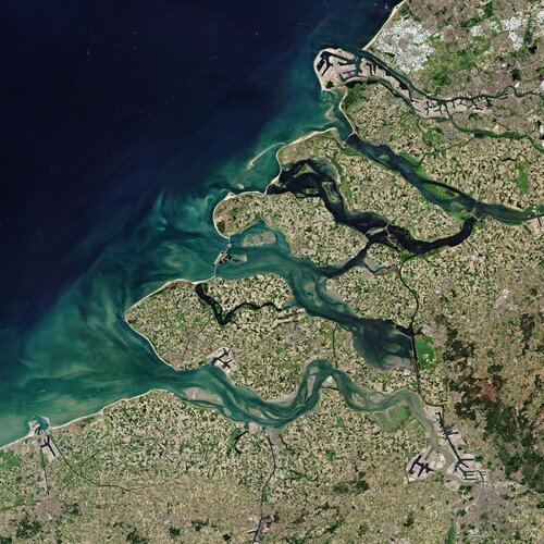 Image:
The Copernicus Sentinel-2 mission takes us over Zeeland – the westernmost province in the Netherlands.
Image:
The Copernicus Sentinel-2 mission takes us over Zeeland – the westernmost province in the Netherlands.
UNOOSA and Centre for Space Science and Technology Education for Asia and the Pacific launch online course on Geospatial Applications for Disaster Risk Management
16.10.2020 9:00 GISCafe.com Webcasts-Webinars VIENNA, 13 October (United Nations Information Service) —Marking International Day for Disaster Reduction today, the United Nations Office for …Bluesky Funds University of Leicester Study into use of LiDAR for Detailed Tree Analysis
16.10.2020 9:00 GISCafe.com Webcasts-Webinars Leicestershire, UK, 12 October 2020 - Bluesky International is partnering with the University of Leicester to co-fund an advanced postgraduate degree …ClearPathGPS Expands Management Team, Hires Additional Staff, As Customer Demand Increases
16.10.2020 9:00 GISCafe.com Webcasts-Webinars Leading GPS fleet tracking provider continues to grow — with heightened demand from service businesses throughout COVID.Santa Barbara, …
New Light Technologies and Econometrica Team Win New Contracts with the U.S. Census Bureau to Develop Next-Generation Statistical Data Products and Disclosure Avoidance Solutions
16.10.2020 9:00 GISCafe.com Webcasts-Webinars WASHINGTON, Oct. 12, 2020 — (PRNewswire) — New Light Technologies Inc. (NLT), a leading provider of cloud, cybersecurity, software …Ground motion mapping services to support reconstruction in Indonesia after earthquake
16.10.2020 9:00 GISCafe.com Webcasts-Webinars On 28 September 2018, a 7.5 magnitude earthquake, followed by a tsunami hit the island of Sulawesi, Indonesia. The natural disaster killed over 2,000 …UN Nations Office for Outer Space Affairs and Ben-Gurion University of the Negev agree to establish Regional Support Office in Israel for UN-SPIDER
16.10.2020 9:00 GISCafe.com Webcasts-Webinars VIENNA, 12 October (United Nations Information Service) — The United Nations Office for Outer Space Affairs (UNOOSA) and the Ben-Gurion …Aerial mapper Aerometrex has signed major corporates Suncorp and Geoscape Australia to its digital imagery service as its subscription model continues to gain pace.
16.10.2020 9:00 GISCafe.com Webcasts-Webinars The two contracts are worth a minimum of $860,000, taking the total value of new subscriptions in the September quarter to more than $1 million. …Schneider Electric releases arcfm mobile 11.2.1
16.10.2020 9:00 GISCafe.com Webcasts-Webinars ArcFM Mobile XI closes the “paper gap” with a full digital design-construction workflowFort Collins, Colo., Oct. 13, 2020 – …
Honeywell Acquires Ballard Unmanned Systems
16.10.2020 9:00 GISCafe.com Webcasts-Webinars -- Acquisition enters Honeywell into the hydrogen fuel cells market for unmanned aerial systems and broader aviation applicationsPHOENIX, Oct. 15, …
EIVA launches a self-service portal for NaviSuite software
16.10.2020 9:00 GISCafe.com Webcasts-Webinars EIVA launches a self-service portal for NaviSuite software EIVA has announced the launch of My EIVA, their new self-service licence administration …
Nové číslo GaKO
16.10.2020 8:00
ÚGKK SR
Nové číslo časopisu Geodetického a Kartografického Obzoru 10/2020