


![]()

zprávy
zdroje zpráv:ArcGIS Utility Network
21.9.2020 12:27 blog ARCDATA ArcGIS Utility Network je nová generace datového modelu Esri pro inženýrské sítě. Co vše tato technologie přináší a proč je nyní nejlepší čas, aby do ní správci inženýrských sítí začali svá data převádět?Plans underway for new polar ice and snow topography mission
21.9.2020 12:00 ESA Observing the Earth
Monitoring the cryosphere is essential to fully assess, predict and adapt to climate variability and change. Given the importance of this fragile component of the Earth system, today ESA, along with Airbus Defence and Space and Thales Alenia Space, have signed a contract to develop the Copernicus Polar Ice and Snow Topography Altimeter mission, known as CRISTAL.
Invitation to Tender: Integrity Service Complementing EGNSS High Accuracy
21.9.2020 10:42 European GNSS Agency
The European Commission’s Directorate-General for Defence Industry and Space (DG-DEFIS) has issued an Invitation to Tender (ITT) for a service contract to address how the future evolution of European GNSS (EGNSS) could be beneficial for innovative demanding applications. The new service contract shall assess the feasibility of an integrity service complementing EGNSS High Accuracy in the 2030+ timeframe.
The new service contract will feed into the evolving needs of demanding new applications without disrupting the current business models of established service providers. This action serves to assess the respective merits of various directions for the Galileo and EGNOS services to evolve and to build roadmaps of the steps needed before operational introduction of such new services.
A webinar to explain the framework and objectives of the procurement and the different tasks in the procurement is planned on 23 September 2020 at 16:00 CEST. You can register here.
More information about the Invitation to Tender (ITT) and the contract notice publication can be found here.
Tailored premiums
Emerging/Next-generation applications will require more demanding positioning solutions to be able to offer innovative services in the future. What could be the role of EGNOS and Galileo in the 2030+ timeframe for demanding and innovative applications?
Read this: First Galileo-enabled autonomous vehicle successfully demonstrated
The European Commission is currently specifying the long-term evolution of the EGNSS programme, including new services for Galileo and EGNOS. The use of an integrity service complementing European GNSS (EGNSS) High Accuracy in the 2030 horizon could result in the provision of an accurate and reliable positioning solution which would translate into the overall improvement of future innovative and demanding services.
Galileo is Europe’s Global Navigation Satellite System (GNSS) providing an accurate, guaranteed global positioning service under civilian control. Galileo is operational since the Initial Service declaration at the end of 2016. As part of the main services provided by Galileo, the Galileo High-Accuracy Service (HAS) shall provide in the near future a high-accuracy positioning and synchronisation information.
EGNOS is the European SBAS and augments GPS L1 C/A civilian signal by providing corrections and integrity information for positioning and navigation applications over Europe. EGNOS version 3, will in the near future augment both GPS and Galileo constellations in the L1 and L5 bands and will extend the service area to the entire landmasses of EU Member States. New EGNOS services could be implemented in further releases of EGNOS as an option for the integrity service complementing EGNSS High Accuracy.
Media note: This feature can be republished without charge provided the European GNSS Agency (GSA) is acknowledged as the source at the top or the bottom of the story. You must request permission before you use any of the photographs on the site. If you republish, we would be grateful if you could link back to the GSA website (http://www.gsa.europa.eu).
Invitation to Tender: Integrity Service Complementing EGNSS High Accuracy
21.9.2020 10:42 European GNSS AgencyThe European Commission’s Directorate-General for Defence Industry and Space (DG-DEFIS) has issued an Invitation to Tender (ITT) for a service contract to address how the future evolution of European GNSS (EGNSS) could be beneficial for innovative demanding applications. The new service contract shall assess the feasibility of an integrity service complementing EGNSS High Accuracy in the 2030+ timeframe.
The new service contract will feed into the evolving needs of demanding new applications without disrupting the current business models of established service providers. This action serves to assess the respective merits of various directions for the Galileo and EGNOS services to evolve and to build roadmaps of the steps needed before operational introduction of such new services.
A webinar to explain the framework and objectives of the procurement and the different tasks in the procurement took place on 23 September 2020 at 16:00 CEST. You can check the presentation here.
More information about the Invitation to Tender (ITT) and the contract notice publication can be found here.
Tailored premiums
Emerging/Next-generation applications will require more demanding positioning solutions to be able to offer innovative services in the future. What could be the role of EGNOS and Galileo in the 2030+ timeframe for demanding and innovative applications?
Read this: First Galileo-enabled autonomous vehicle successfully demonstrated
The European Commission is currently specifying the long-term evolution of the EGNSS programme, including new services for Galileo and EGNOS. The use of an integrity service complementing European GNSS (EGNSS) High Accuracy in the 2030 horizon could result in the provision of an accurate and reliable positioning solution which would translate into the overall improvement of future innovative and demanding services.
Galileo is Europe’s Global Navigation Satellite System (GNSS) providing an accurate, guaranteed global positioning service under civilian control. Galileo is operational since the Initial Service declaration at the end of 2016. As part of the main services provided by Galileo, the Galileo High-Accuracy Service (HAS) shall provide in the near future a high-accuracy positioning and synchronisation information.
EGNOS is the European SBAS and augments GPS L1 C/A civilian signal by providing corrections and integrity information for positioning and navigation applications over Europe. EGNOS version 3, will in the near future augment both GPS and Galileo constellations in the L1 and L5 bands and will extend the service area to the entire landmasses of EU Member States. New EGNOS services could be implemented in further releases of EGNOS as an option for the integrity service complementing EGNSS High Accuracy.
Media note: This feature can be republished without charge provided the European GNSS Agency (GSA) is acknowledged as the source at the top or the bottom of the story. You must request permission before you use any of the photographs on the site. If you republish, we would be grateful if you could link back to the GSA website (http://www.gsa.europa.eu).
Nové ruční skenery GeoSLAM ZEB Go a ZEB Go RT
21.9.2020 9:47 ZeměměřičDo rodiny skenerů od britské firmy GeoSLAM přibyly na přelomu srpna a září dva produkty. Nové ruční skenery firma pojmenovala GeoSLAM ZEB Go a ZEB Go RT a vycházejí ze známé série ZEB Revo. U základního modelu není vidět na skenovaná data, takže musíte po skenování udělat postprocessing dat. Naopak na model s označením RT, což znamená “real time”, připojíte […]
The post Nové ruční skenery GeoSLAM ZEB Go a ZEB Go RT appeared first on Zeměměřič.
Ocenění Year in Infrastructure 2020, pořádané firmou Bentley Systems, zná finalisty
21.9.2020 8:48 GeoBusinessFirma Bentley Systems vyhlásila finalisty své každoroční soutěže Year in Infrastructure 2020 (YII 2020). V soutěži je oceněna práce zákazníků Bentley Systems, kteří s jejich softwarem pracují v projektování, výstavbě a provozování infrastruktur po celém světě. Do soutěže se tentokrát přihlásilo 330 organizací s více než 400 nominovanými projekty. Z nich šestnáct nezávislých porot vybralo […]
The post Ocenění Year in Infrastructure 2020, pořádané firmou Bentley Systems, zná finalisty appeared first on GeoBusiness.
Aplikace ForestGuard zvítězila v soutěži IT projekt roku 2019 (TZ)
21.9.2020 8:28 GISportal.cz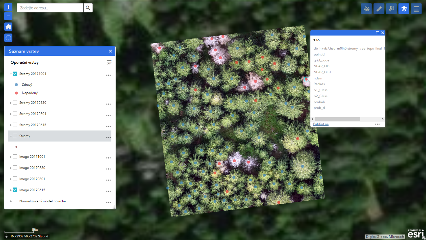
V úterý 15.9.2020 proběhlo slavnostní vyhlášení soutěže IT projekt roku 2019, kterou pořádá Česká asociace manažerů informačních technologií (CACIO). Vítězem se stala aplikace ForestGuard (dříve nazývaná Brouk), která umožňuje majitelům či správcům lesů detekci stromů napadených lýkožroutem smrkovým (kůrovcem). Vyvinula ji společnost Unicorn ve spolupráci s vědci z Fakulty životního prostředí České zemědělské univerzity v Praze. Pro boj […]
The post Aplikace ForestGuard zvítězila v soutěži IT projekt roku 2019 (TZ) appeared first on GISportal.cz.
Pobočka Trutnov je opět otevřena veřejnosti
21.9.2020 0:00 Státní pozemkový úřad Dovolujeme si Vám oznámit, že pobočka Trutnov je opět otevřena pro veřejnost. Omlouváme se za komplikace, které Vám uzavřením pobočky vznikly a děkujeme za pochopení.Pobočka Trutnov je opět otevřena veřejnosti
21.9.2020 0:00 Státní pozemkový úřad Dovolujeme si Vám oznámit, že pobočka Trutnov je opět otevřena pro veřejnost. Omlouváme se za komplikace, které Vám uzavřením pobočky vznikly a děkujeme za pochopení.Pobočka Trutnov je opět otevřena veřejnosti
21.9.2020 0:00 Státní pozemkový úřad Dovolujeme si Vám oznámit, že pobočka Trutnov je opět otevřena pro veřejnost. Omlouváme se za komplikace, které Vám uzavřením pobočky vznikly a děkujeme za pochopení.Pobočka Trutnov je dočasně uzavřena veřejnosti
21.9.2020 0:00 Státní pozemkový úřad Dovolujeme si Vám oznámit, že z provozně technických důvodů je pro veřejnost uzavřena pobočka Trutnov. Veškerá vaše podání budou vyřizována elektronicky. Omezení platí do odvolání. O znovuotevření pobočky vás budeme neprodleně informovat. Děkujeme za pochopení.Pobočka Trutnov je dočasně uzavřena veřejnosti
21.9.2020 0:00 Státní pozemkový úřad Dovolujeme si Vám oznámit, že z provozně technických důvodů je pro veřejnost uzavřena pobočka Trutnov. Veškerá vaše podání budou vyřizována elektronicky. Omezení platí do odvolání. O znovuotevření pobočky vás budeme neprodleně informovat. Děkujeme za pochopení.Pobočka Trutnov je dočasně uzavřena veřejnosti
21.9.2020 0:00 Státní pozemkový úřad Dovolujeme si Vám oznámit, že z provozně technických důvodů je pro veřejnost uzavřena pobočka Trutnov. Veškerá vaše podání budou vyřizována elektronicky. Omezení platí do odvolání. O znovuotevření pobočky vás budeme neprodleně informovat. Děkujeme za pochopení.Digitální stavební deník Stavee ušetří finance
20.9.2020 9:02 GeoBusinessStavba, stavebník, investor a jeho dodavatel však často používají stavební deník v podobě sešitu, který si obstaráte v nejbližším papírnictví. To je přes čtyřicet let realita českého stavebnictví, které se chce digitalizovat, aby bylo více efektivní. Podstatou stavebního deníku je mít pro každý den záznam o průběhu výstavby a evidovat informace jako jsou provedené práce, […]
The post Digitální stavební deník Stavee ušetří finance appeared first on GeoBusiness.
Hackathon se 13 výzvami. To je Covid-19 INSPIRE Hackathon 2020
19.9.2020 22:25 GeoBusinessCOVID-19 INSPIRE Hackathon a Ideathon 2020 se koná od začátku září až do poloviny listopadu (1. září až 16. listopadu 2020). Postupně se můžete zúčastnit celkem 13 publikovaných výzev. Vybrat si přitom můžete jednu, více nebo všechny. Záleží to na vás, na co budete mít čas. Registrační formulář pro vyjádření vašeho zájmu o účast v hackathonu. […]
The post Hackathon se 13 výzvami. To je Covid-19 INSPIRE Hackathon 2020 appeared first on GeoBusiness.
Hackathon se 13 výzvami. To je Covid-19 INSPIRE Hackathon 2020
19.9.2020 22:25 GeoBusinessCOVID-19 INSPIRE Hackathon a Ideathon 2020 se koná od začátku září až do poloviny listopadu (1. září až 16. listopadu 2020). Postupně se můžete zúčastnit celkem 13 publikovaných výzev. Vybrat si přitom můžete jednu, více nebo všechny. Záleží to na vás, o co budete míz zájem a na co čas. Registrační formulář pro vyjádření vašeho […]
The post Hackathon se 13 výzvami. To je Covid-19 INSPIRE Hackathon 2020 appeared first on GeoBusiness.
Call for papers for a GIS Day Event - “Health GIS: STAR (Spatial Thinking in Applied Research)”
19.9.2020 16:12 GISCafe.com Webcasts-WebinarsOGC and ODA Announce Strategic Partnership
18.9.2020 21:59 GISCafe.com Webcasts-Webinars Partnership between OGC and the Open Design Alliance will promote cooperation on open geospatial standards and allow users to do more with BIM, CAD, …New OGC API standard for geospatial processing across the web; public comment sought before approval
18.9.2020 21:35 GISCafe.com Webcasts-Webinars OGC API - Processes simplifies the task of making simple or complex computational geospatial processing services accessible via web services.17 …
Orbit Logic Awarded AFRL/AFWERX Space Situational Awareness Planning and Analysis Contract
18.9.2020 21:24 GISCafe.com Webcasts-Webinars GREENBELT, MD (September 14th, 2020) – Orbit Logic, a leading provider of planning and scheduling software, announced today that it has been …US West Coast on fire
18.9.2020 18:05 ESA Observing the Earth
Over the past month, dozens of wildfires have burned vast swathes of land in California, Oregon and Washington State, killing more than 30 people and smothering the majority of the western United States in smoke. While photographs have circulated online showing the apocalyptic orange skies, satellites in orbit around Earth carry different instruments that can provide not only images, but a wealth of complementary information needed to monitor the blazes.
US West Coast on fire
18.9.2020 18:05 ESA Observing the Earth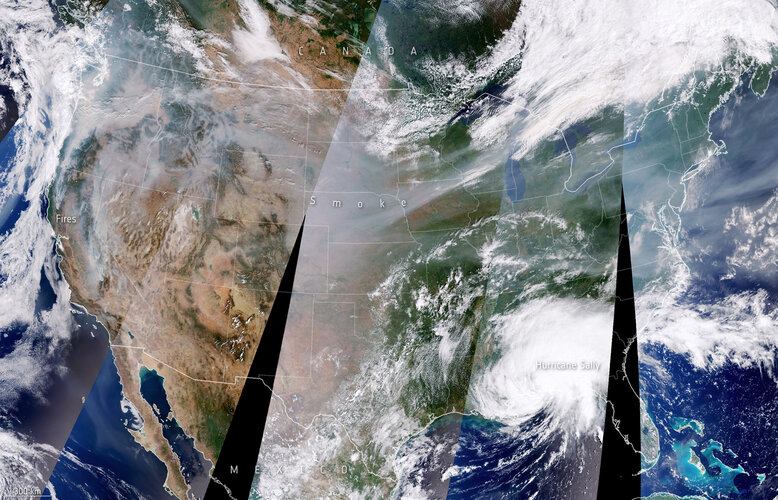
Over the past month, dozens of wildfires have burned vast swathes of land in California, Oregon and Washington State, killing more than 30 people and smothering the majority of the western United States in smoke. While photographs have circulated online showing the apocalyptic orange skies, satellites in orbit around Earth carry different instruments that can provide not only images, but a wealth of complementary information needed to monitor the blazes.
European Association of Aerial Surveying Industries Gather Virtually for First AGM
18.9.2020 16:23 GISCafe.com Webcasts-Webinars Brussels, 18 September 2020 – On 02 September 2020, the European Association of Aerial Surveying Industries, held the First Annual General …Dronegenuity Launches Online Drone Training Platform
18.9.2020 16:23 GISCafe.com Webcasts-Webinars Dronegenuity Launches Online Part 107 Test Prep Course as an introduction to its drone training services.BOSTON, Sept. 17, 2020 — (PRNewswire) …
GIC Collects Wildfire Imagery Across The Western U.S.
18.9.2020 16:23 GISCafe.com Webcasts-Webinars High Resolution Imagery Is Now Available to Help Insurers Respond Safer and Faster to Recent Wildfire DisastersDES PLAINES, Ill., Sept. 17, 2020 …
Air pollution in a post-COVID-19 world
18.9.2020 12:00 ESA Observing the Earth
Air pollution is one of the biggest environmental problems of our time. According to a new report from the European Environment Agency (EEA), air pollution now contributes to one in eight deaths in Europe. Observations from the Copernicus Sentinel-5P satellite have been vital in tracking the evolution of air pollution, specifically nitrogen dioxide concentrations, across Europe.
Air pollution in a post-COVID-19 world
18.9.2020 12:00 ESA Observing the Earth
Air pollution is one of the biggest environmental problems of our time. According to a new report from the European Environment Agency (EEA), air pollution now accounts for one in eight deaths in Europe. Observations from the Copernicus Sentinel-5P satellite have been vital in tracking the evolution of air pollution, specifically nitrogen dioxide concentrations, across Europe.
Esri kupuje firmu nFrames, která má software pro 3D modelování z obrazových dat
18.9.2020 10:27 GeoBusinessFirma Esri oznámila, že kupuje firmu nFrames, stojící za vývojem softwaru SURE. Software SURE se používá pro zpracování obrazových (leteckých, fotogrammetrických) a lidarových dat. Akvizice firmy je v podstatě pokračováním toho, co Esri udělala v roce 2011, kdy koupila firmu Procedural a jejich software CityEngine. Software SURE bude začleněn do platformy ArcGIS a má uživatelům […]
The post Esri kupuje firmu nFrames, která má software pro 3D modelování z obrazových dat appeared first on GeoBusiness.
Earth from Space: Vatnajökull
18.9.2020 10:00 ESA Observing the Earth Video:
00:03:04
Video:
00:03:04
In this week's edition of the Earth from Space programme, the Copernicus Sentinel-2 mission takes us over the Vatnajökull ice cap, in southeast Iceland.
See also Vatnajökull, Iceland to download the image.
Vatnajökull, Iceland
18.9.2020 10:00 ESA Observing the Earth Image:
The Copernicus Sentinel-2 mission takes us over the Vatnajökull ice cap, in southeast Iceland.
Image:
The Copernicus Sentinel-2 mission takes us over the Vatnajökull ice cap, in southeast Iceland.
Müllerova mapa Čech letos slaví 300 let a k výročí bude seminář a výstava v Národním technickém muzeu
18.9.2020 9:53 ZeměměřičNárodní technické muzeum a Česká kartografická společnost ve spolupráci s partnery, kterými jsou pro tuto akci Česká geografická společnost, Historický ústav AV ČR, Fakulta stavební ČVUT v Praze, Filozofická fakulta UJEP Ústí nad Labem a pořádají ve čtvrtek 1. října 2020 od 10 hodin odborný seminář Kartografická výročí 2020: 300 let Müllerovy mapy Čech. Seminář k 300. výročí vydání výjimečného kartografického díla […]
The post Müllerova mapa Čech letos slaví 300 let a k výročí bude seminář a výstava v Národním technickém muzeu appeared first on Zeměměřič.
Medicane Ianos
18.9.2020 9:10 ESA Observing the Earth Image:
Copernicus Sentinel-3 captured this image of the Mediterranean hurricane, or ‘Medicane,’ crossing the Ionian Sea and approaching Greece yesterday 17 September.
Image:
Copernicus Sentinel-3 captured this image of the Mediterranean hurricane, or ‘Medicane,’ crossing the Ionian Sea and approaching Greece yesterday 17 September.
Kleos Space -Scouting Mission Launch Update
18.9.2020 9:00 GISCafe.com Webcasts-Webinars Luxembourg, 17 September 2020: Kleos Space S.A (ASX:KSS, Frankfurt:KS1), a space-powered Radio Frequency Reconnaissance data-as-a-service (DaaS) …The International Alliance for Mobility Testing & Standardization (IAMTS) Adds VdTÜV, 3D Mapping Solutions, Humanetics, Flaming Creations and TalTech
17.9.2020 17:46 GISCafe.com Webcasts-Webinars Strong growth continues for the consortium focused on autonomous vehicle testing.WARRENDALE, Pa., Sept. 17, 2020 — (PRNewswire) — …
Bluesky 3D Building Models Provide Sense of Place for London Design Agency
17.9.2020 16:46 GISCafe.com Webcasts-Webinars Leicestershire, UK, 17 September 2020 – London agency DCSK is using 3D building models from Bluesky to inform the design of high profile urban …Maxar Awarded Contract to Build Sixth Geostationary Communications Satellite for Intelsat in 2020
17.9.2020 16:46 GISCafe.com Webcasts-Webinars WESTMINSTER, Colo. — (BUSINESS WIRE) — September 17, 2020 —Maxar Technologies (NYSE:MAXR) (TSX:MAXR), a trusted partner and …
Computer Vision Company Chooch AI Makes Breakthroughs in Edge AI in Speed, Accuracy and Scale
17.9.2020 16:46 GISCafe.com Webcasts-Webinars SAN FRANCISCO, Sept. 17, 2020 (GLOBE NEWSWIRE) -- Chooch AI, a horizontal computer vision AI platform, today published the latest video …Esri Enters into Memorandum of Understanding with UN-Habitat
17.9.2020 16:46 GISCafe.com Webcasts-Webinars Agreement Empowers United Nations Organization to Use Location Intelligence to Build Sustainable Communities GloballyREDLANDS, Calif. — …
Facebook stránka o budovaní INSPIRE na Slovensku
17.9.2020 16:14 Geocommunity.skPríspevok Facebook stránka o budovaní INSPIRE na Slovensku zobrazený najskôr GeoCommunity.sk.
Facebook stránka o budovaní INSPIRE na Slovensku
17.9.2020 16:14 Geocommunity.skPríspevok Facebook stránka o budovaní INSPIRE na Slovensku zobrazený najskôr GeoCommunity.sk.
Do otevřených dat a mapových k
17.9.2020 13:25 Jihočeský kraj Do otevřených dat a mapových kompozic v záložce ke stažení byla aktualizována Mapa silniční sítě Jihočeského kraje k 1.1.2020.Mapa silniční sítě Jihočeského kraje
17.9.2020 13:25 Jihočeský kraj V sekci ke stažení je k dispozici aktualizovaná Mapa silniční sítě Jihočeského kraje k 1.1.2020.High-resolution methane emissions data for waste management
17.9.2020 11:00 ESA Observing the Earth
Copernicus Sentinel-5P’s high revisit rate combined with GHGSat’s high-resolution commercial imagery can give landfill operators and regulators the information they need to reduce methane emissions from landfill sites.
Satellite data help climbers ascend Mount Everest
17.9.2020 9:40 ESA Observing the Earth Image:
Satellite data help climbers ascend Mount Everest
Image:
Satellite data help climbers ascend Mount Everest
Eos Positioning Systems announces compatibility of Eos Locate™ for ArcGIS with Subsite® Electronics Products
17.9.2020 9:00 GISCafe.com Webcasts-Webinars The expansion makes the Eos Locate™ for ArcGIS, an underground asset-mapping solution, compatible with Bluetooth-enabled Subsite …Quantela Deploys Smart City Technology to Combat COVID-19 in the USA
16.9.2020 20:36 GISCafe.com Webcasts-Webinars MILPITAS, Calif., Sept. 16, 2020 (GLOBE NEWSWIRE) -- Smart Cities innovator, Quantela, today announced the first US deployment of their Coronavirus …Fortem Technologies Adds New Capabilities to Autonomously Capture a Wider Array of Drone Threats, Including Faster Moving Fixed Wing Drones
16.9.2020 20:36 GISCafe.com Webcasts-Webinars Pleasant Grove, UT, Sept. 16, 2020 (GLOBE NEWSWIRE) -- Fortem Technologies Inc., a leader in airspace security and defense for detecting and …Zdarma geodetický software Kokeš 14 pro studenty středních a vysokých škol v ČR i SR
16.9.2020 18:24 ZeměměřičFirma GEPRO, oznámila, že geodetický software KOKEŠ 14 TRIAL je po letní přestávce opět k dispozici studentům středních a vysokých škol v České republice a Slovenské republice, kteří potřebují pracovat s programem KOKEŠ a nebudou moci do školních učeben. Jde o plnohodnotný software KOKEŠ-STANDARD, který není funkčně žádným způsobem omezen, k dispozici je zdarma. Nutnou podmínkou k provozování systému KOKEŠ 14 TRIAL je připojení k internetu […]
The post Zdarma geodetický software Kokeš 14 pro studenty středních a vysokých škol v ČR i SR appeared first on Zeměměřič.
IPO firmy Bentley Systems. Producent CAD softwaru MicroStation jde na burzu
16.9.2020 17:52 GeoBusinessSpolečnost Bentley Systems oznámila záměr vstoupit na burzu a v prvotním úpisu akcií nabídnout 10,75 milionu akcií Class B (akcie s nižšími rozhodovacími pravomocemi). Firma Bentley Systems je známá díky svým softwarům MicroStation či ProjectWise, které se používají především v souvislosti s infrastrukturními projekty. Na burzu chce firma vstoupit se symbolem BSY. Následuje tisková zpráva, […]
The post IPO firmy Bentley Systems. Producent CAD softwaru MicroStation jde na burzu appeared first on GeoBusiness.
IPO firmy Bentley Systems. Producent CAD softwaru MicroStation si jde pro peníze na burzu
16.9.2020 17:52 GeoBusinessSpolečnost Bentley Systems oznámila záměr vstoupit na burzu a v prvotním úpisu akcií nabídnout 10,75 milionu akcií Class B (akcie s nižšími rozhodovacími pravomocemi). Firma Bentley Systems je známá díky svým softwarům MicroStation či ProjectWise, které se používají především v souvislosti s infrastrukturními projekty. Na burzu chce firma vstoupit se symbolem BSY. Následuje tisková zpráva, […]
The post IPO firmy Bentley Systems. Producent CAD softwaru MicroStation si jde pro peníze na burzu appeared first on GeoBusiness.
KOKEŠ 14 TRIAL opět na scéně
16.9.2020 17:47 GEPROKOKEŠ 14 TRIAL je po letní přestávce opět k dispozici studentům středních a vysokých škol v České republice a Slovenské republice, kteří potřebují pracovat se systémem KOKEŠ a nebudou moci do školních učeben.… >>
Na dnech otevřených dveří v Geotronics Praha bude k vidění technika pro geodézii i GIS
16.9.2020 17:10 GeoBusinessSpolečnost Geotronics Praha oznámila termíny svých dnů otevřených dveří. Jeden z nich bude věnován geodézii, druhý řešením pro GIS. Pořadatelé v pozvánce vysvětlují, že: 1. října Vám rádi osobně předvedeme na Dni otevřených dveří pro GEODÉZII špičkové technologie pro geodetické měření, 3D skenování i bezpilotní snímkování a zodpovíme Vaše dotazy. 8. října si můžete prohlédnout na […]
The post Na dnech otevřených dveří v Geotronics Praha bude k vidění technika pro geodézii i GIS appeared first on GeoBusiness.
Den otevřených dveří v Geotronics Praha
16.9.2020 17:06 ZeměměřičSpolečnost Geotronics Praha oznámila termíny svých dnů otevřených dveří. Jeden z nich bude věnován geodézii, druhý řešením pro GIS. Pořadatelé v pozvánce vysvětlují, že: 1. října Vám rádi osobně předvedeme na Dni otevřených dveří pro GEODÉZII špičkové technologie pro geodetické měření, 3D skenování i bezpilotní snímkování a zodpovíme Vaše dotazy. 8. října si můžete prohlédnout na Dni otevřených dveří pro GIS technologie […]
The post Den otevřených dveří v Geotronics Praha appeared first on Zeměměřič.
Bentley Systems announces new series on ITwins for executives
16.9.2020 16:50 Bentley SystemsPress Coverage
Graphic Speak, USA
Read the articleHP Introduces Its Best Printer for Today’s Distributed Workforce
16.9.2020 16:50 GISCafe.com Webcasts-Webinars PALO ALTO, Calif., Sept. 16, 2020 (GLOBE NEWSWIRE) -- Today at HP Reinvent, HP Inc.’s annual global partner event, the company introduced the HP …HERE offers developers and data scientists direct access to rich geospatial data
16.9.2020 16:50 GISCafe.com Webcasts-Webinars Precise representation of the world’s road networks, pathways, buildings, structures, places, land use and land coverGeospatial datasets for a wide …Enview Unveils First-of-its-Kind 3D AI as a Web Application, Enview Explore™
16.9.2020 16:50 GISCafe.com Webcasts-Webinars Application Empowers Users with Expert Visualization and Analysis of LiDAR; Former NGA Director Robert Cardillo Joins Company's Board of …RapidDeploy Enters into Agreements with Google, OnStar, ADT, Priority Dispatch and Rave Mobile Safety to Transform U.S. Emergency Response Systems
16.9.2020 16:50 GISCafe.com Webcasts-Webinars Industry's Premier Platform Teams up with Leading Technology Companies to Unify Public Safety WorkflowAUSTIN, Texas, Sept. 16, 2020 — …
Pure Storage to Acquire Portworx, Creating the Industry's Most Complete Kubernetes Data Services Platform for Cloud Native Applications
16.9.2020 16:50 GISCafe.com Webcasts-Webinars To accelerate customers' hybrid and multi-cloud strategies, Pure to provide Kubernetes data services that run on any cloud, any storage, and any …BIM Software Shows the Future
16.9.2020 16:22 Bentley SystemsPress Coverage
International Construction, UK
Read the articleCityringen Metro, Copenhagen, Denmark
16.9.2020 14:48 Bentley SystemsPress Coverage
Railway Technology, UK
Read the articleProviding the facts to help Europe achieve 55%
16.9.2020 14:48 ESA Observing the Earth
Today, at her State of the Union address before the European Parliament, Ursula von der Leyen, President of the European Commission, proposed a new target of a 55% cut in greenhouse gas emissions by 2030, compared to 1990 levels. The current target is a 40% reduction. With such ambitious goals ahead for Europe, understanding how greenhouse gases end up in the atmosphere and the intricacies of the carbon cycle is essential – something that satellites observing Earth can help provide.
The third edition of the GNSS User Technology Report is coming soon.
16.9.2020 11:36 European GNSS Agency
The European GNSS Agency’s (GSA) User Technology Report 2020 is on the horizon. In this issue, the Report will present an overview of the current GNSS user technology trends and developments across four macrosegments: high volume devices, safety- and liability-critical devices, high-accuracy devices, timing devices.
Already at its third edition, the GNSS User Technology Report provides - together with its sister publication the GNSS Market Report - market intelligence, expert analysis on the industry’s dynamics and trending domains. The report is referenced extensively by industry and decision-makers and its 2018 edition has been downloaded over 7500 times.
The 2020 Report starts with an overview of GNSS, RNSS and SBAS updates followed by a summary of recent developments and future trends in GNSS user technology, common to all device types. It then takes an in-depth look into four macrosegments defined on the basis of commonalities from the technology point-of view: high volume devices, safety- and liability-critical devices, high-accuracy devices and newly timing devices. Each chapter starts with the macrosegment characteristics and receiver capabilities, depicts the industry landscape and typical receiver form factor, it then delves into the key current and future drivers and trends, and finishes with the added value of the EGNSS for the macrosegment at stake.
To be among the first ones to download the publication register here.
In the 2020 issue, the Editor´s special focuses on Space Data for Europe, and the role of flagship European Space Programmes, Copernicus and Galileo. It also provides a vision of major transformations under way within our society and our economy, and benefits expected from this digital transformation, including to enable the European Data Strategy or Green Deal.
Read this: GNSS User Technology Report Issue 2 (2018)
A sneak peek from this year’s report:
• Multi-constellation is already standard in most of the segments, GNSS receivers across all domains are now more commonly featuring multi-frequency support in order to deliver better performances to end users (primarily greater accuracy and robustness to interferences);
• There are many high-accuracy services now available on the market to all category of users;
• Protection measures against GNSS jamming and spoofing are implemented through different combinations of technologies on both the receivers and their antennas, through the use of multiple sources of positioning information as well as the authentication of GNSS signals;
• Sensors of all types are now routinely integrated with GNSS receivers and their outputs; While largely propelled by the emerging world of ‘autonomous things’, this trend widely benefit to other sectors, leading to ubiquitous localization and timing, ubiquitous sensing, ubiquitous connectivity, where each subsystem contributes to the performance of the others and where the seamless integration of space and ground components is paramount to achieve truly global ubiquity.
Read this: GNSS Market Report Issue 6 (2019)
Interested in the full report? Register here to receive in your inbox a notification about the official release of the GNSS User Technology Report 2020.
Media note: This feature can be republished without charge provided the European GNSS Agency (GSA) is acknowledged as the source at the top or the bottom of the story. You must request permission before you use any of the photographs on the site. If you republish, we would be grateful if you could link back to the GSA website (http://www.gsa.europa.eu).
The third edition of the GNSS User Technology Report is coming soon
16.9.2020 11:36 European GNSS AgencyThe European GNSS Agency’s (GSA) User Technology Report 2020 is on the horizon. In this issue, the Report will present an overview of the current GNSS user technology trends and developments across four macrosegments: high volume devices, safety- and liability-critical devices, high-accuracy devices, timing devices.
Already at its third edition, the GNSS User Technology Report provides - together with its sister publication the GNSS Market Report - market intelligence, expert analysis on the industry’s dynamics and trending domains. The report is referenced extensively by industry and decision-makers and its 2018 edition has been downloaded over 7500 times.
The 2020 Report starts with an overview of GNSS, RNSS and SBAS updates followed by a summary of recent developments and future trends in GNSS user technology, common to all device types. It then takes an in-depth look into four macrosegments defined on the basis of commonalities from the technology point-of view: high volume devices, safety- and liability-critical devices, high-accuracy devices and newly timing devices. Each chapter starts with the macrosegment characteristics and receiver capabilities, depicts the industry landscape and typical receiver form factor, it then delves into the key current and future drivers and trends, and finishes with the added value of the EGNSS for the macrosegment at stake.
To be among the first ones to download the publication register here.
In the 2020 issue, the Editor´s special focuses on Space Data for Europe, and the role of flagship European Space Programmes, Copernicus and Galileo. It also provides a vision of major transformations under way within our society and our economy, and benefits expected from this digital transformation, including to enable the European Data Strategy or Green Deal.
Read this: GNSS User Technology Report Issue 2 (2018)
A sneak peek from this year’s report:
• Multi-constellation is already standard in most of the segments, GNSS receivers across all domains are now more commonly featuring multi-frequency support in order to deliver better performances to end users (primarily greater accuracy and robustness to interferences);
• There are many high-accuracy services now available on the market to all category of users;
• Protection measures against GNSS jamming and spoofing are implemented through different combinations of technologies on both the receivers and their antennas, through the use of multiple sources of positioning information as well as the authentication of GNSS signals;
• Sensors of all types are now routinely integrated with GNSS receivers and their outputs; While largely propelled by the emerging world of ‘autonomous things’, this trend widely benefit to other sectors, leading to ubiquitous localization and timing, ubiquitous sensing, ubiquitous connectivity, where each subsystem contributes to the performance of the others and where the seamless integration of space and ground components is paramount to achieve truly global ubiquity.
Read this: GNSS Market Report Issue 6 (2019)
Interested in the full report? Register here to receive in your inbox a notification about the official release of the GNSS User Technology Report 2020.
Media note: This feature can be republished without charge provided the European GNSS Agency (GSA) is acknowledged as the source at the top or the bottom of the story. You must request permission before you use any of the photographs on the site. If you republish, we would be grateful if you could link back to the GSA website (http://www.gsa.europa.eu).
"Geodesign is an Angel Investor in Post-COVID Planning Projects" by Jesse Suders
16.9.2020 10:03 GISCafe.com Webcasts-WebinarsARCDATA PRAHA mají nový blog
16.9.2020 8:16 GISportal.cz
Společnost ARCDATA PRAHA nedávno spustila vlastní blog, který bude přinášet novinky, především ze světa Esri. Nablogu naleznete příklady toho, jak systémy GIS v praxi fungují a seznámíte se se zajímavými technologiemi. Ti, kdo s GIS již pracují, zde získají návody a osvědčené pracovní postupy. Jejich blog je tak nejen pomůckou pro ty, kdo s GIS již pracují, ale také průvodcem každému, kdo se […]
The post ARCDATA PRAHA mají nový blog appeared first on GISportal.cz.
Získejte plnou licenci F
16.9.2020 7:56 Adeon Získejte plnou licenci Fusionu 360 s výraznou 40% slevou.
Vyberte si slevu nebo 2 licenc
16.9.2020 0:00 SolidVision Vyberte si slevu nebo 2 licence za cenu 1. Akce trvá do 30.9.2020.Vyberte si slevu nebo 2 licenc
16.9.2020 0:00 SolidVision Vyberte si slevu nebo 2 licence za cenu 1. Akce trvá do 30.9.2020.Bentley Systems Announces Launch of Initial Public Offering
15.9.2020 19:34 GISCafe.com Webcasts-Webinars EXTON, Pa. — (BUSINESS WIRE) — September 15, 2020 —Bentley Systems, Incorporated (“Bentley”) today announced the launch of …
Bentley Systems Announces Launch of Initial Public Offering
15.9.2020 18:16 Bentley Systems EXTON, Pa., U.S.A. – September 15, 2020 – Bentley Systems, Incorporated (“Bentley”) today announced the launch of the initial public offering of 10,750,000 shares of its Class B common stock. The shares of Class B common stock to be sold in the offering will be sold by existing stockholders of Bentley. The selling stockholders expect to grant the underwriters in the offering a 30-day option to purchase up to an additional 1,610,991 shares of Class B common stock from the selling stockholders. The estimated initial public offering price is between $17.00 and $19.00 per share. Bentley has applied to list its shares on the NASDAQ Global Select Market under the symbol “BSY”.Goldman Sachs & Co. LLC and BofA Securities are acting as lead book-running managers and RBC Capital Markets is acting as a book-running manager for the proposed offering. Baird, KeyBanc Capital Markets and Mizuho Securities are acting as co-managers for the proposed offering.
A registration statement on Form S-1 relating to the proposed offering has been filed with the SEC but has not yet become effective. These securities may not be sold nor may offers to buy be accepted prior to the time the registration statement becomes effective. This press release does not constitute an offer to sell or the solicitation of an offer to buy any securities, and shall not constitute an offer, solicitation, or sale in any jurisdiction in which such offer, solicitation, or sale would be unlawful prior to registration or qualification under the securities laws of that jurisdiction. Any offers, solicitations or offers to buy, or any sales of securities will be made in accordance with the registration requirements of the Securities Act of 1933, as amended.
The proposed offering will be made only by means of a prospectus. Copies of the preliminary prospectus related to the offering may be obtained by contacting Goldman Sachs & Co. LLC, Attention: Prospectus Department at 200 West Street, New York, New York 10282, by telephone at 1-866-471-2526 or by e-mail at prospectus-ny@ny.email.gs.com, or BofA Securities, Attn: Prospectus Department, NC1-004-03-43, 200 North College Street, 3rd floor, Charlotte, North Carolina 28255-0001, by email at dg.prospectus_requests@bofa.com.
Forward Looking Statements
This press release contains forward-looking statements. Forward-looking statements include all statements that are not historical facts. The words “believe,” “may,” “will,” “estimate,” “continue,” “anticipate,” “intend,” “expect” and similar expressions are intended to identify forward-looking statements. These forward-looking statements include any statements regarding the commencement of trading of Bentley’s Class B common stock on the Nasdaq Global Select Market. These forward-looking statements are subject to a number of risks, uncertainties and assumptions, including those described under “Risk Factors” under Bentley’s registration statement relating to the offering. Except as required by law, Bentley has no obligation to update any of these forward-looking statements to conform these statements to actual results or revised expectations.
Pozvánka na geodetické Brdy 2020
15.9.2020 17:47 ZeměměřičTradiční podzimní geodetická turistická a společenská akce se letos koná v sobotu 7. listopadu 2020 s cílem Restaurace Karlštejn. Adresa cíle je Karlštejn 201 (naproti nádraží), http://www.karlstejn-penzion.cz/, rezervace cca od 17:00 hod. Brdy 2020 je dobrá příležitost setkat se s bývalými spolužačkami a spolužáky oboru G+K pražské ČVUT se starými i novými přáteli ze zeměměřičské praxe se současnými studenty a studentkami oboru […]
The post Pozvánka na geodetické Brdy 2020 appeared first on Zeměměřič.
Volansi Raises $50 Million to Accelerate Middle-Mile Drone Delivery
15.9.2020 17:32 GISCafe.com Webcasts-Webinars SAN FRANCISCO, Sept. 15, 2020 — (PRNewswire) — Volansi, Inc., the leader in vertical take-off and landing (VTOL) middle-mile drone …AtScale Adds New Datasets and BI Dashboards to AtScale Data Insights Marketplace to Uncover New Insights
15.9.2020 17:32 GISCafe.com Webcasts-Webinars New Datasets from SafeGraph, FiveThirtyEight, the Federal Election Commission, and The New York Times’ COVID-19 PandemicSAN MATEO, Calif. & …
Ecopia.AI Partners with Compagnia Generale Ripreseaeree SpA to Produce Next- Generation Digital Maps of Italy
15.9.2020 17:32 GISCafe.com Webcasts-Webinars TORONTO — (BUSINESS WIRE) — September 15, 2020 —Today, Ecopia.AI (“Ecopia”) announced a partnership with Compagnia Generale …
New Applications From LiquidPiston Enable Aircraft Electrification To Improve Drone and Rotorcraft Flight Duration and Fuel Efficiency
15.9.2020 17:32 GISCafe.com Webcasts-Webinars Using the company’s innovative X-Engine, LiquidPiston is working with the U.S. Army and its xTechSearch small business technology competition to …Dubai Police Select Draganfly to Pilot New Drone Initiatives
15.9.2020 17:32 GISCafe.com Webcasts-Webinars Los Angeles, California, Sept. 15, 2020 (GLOBE NEWSWIRE) -- Draganfly Inc. (OTCQB: DFLYF) (CSE: DFLY) (FSE: 3U8) (“Draganfly” or the …Martin UAV Contracted to Support Deployed Marines
15.9.2020 17:32 GISCafe.com Webcasts-Webinars PLANO, Texas, Sept. 15, 2020 — (PRNewswire) — Martin UAV has been awarded an Other Transaction for Prototype Agreement with …HERE and EROAD expand partnership, launch new navigation tools for commercial vehicle drivers
15.9.2020 17:32 GISCafe.com Webcasts-Webinars EROAD bolsters its focus on driver safety and productivity by partnering with HERE to enable truck-friendly routing and navigation in its solutions …HERE and INRIX build end-to-end parking ecosystem
15.9.2020 17:32 GISCafe.com Webcasts-Webinars INRIX becomes the first parking information provider to distribute data to and through multiple HERE channelsAmsterdam, The Netherlands - HERE …DirtWork Alert: Satellite Imagery AI/ML Predicts 1 in 3 Permian Basin Oil Wells before Permits
15.9.2020 17:32 GISCafe.com Webcasts-Webinars White Paper analyzing 12,854 Permian Basin oil and gas wells shows DirtWork Alert™ satellite imagery service accurately predicts new oilfield … Image:
Spalte break up
Image:
Spalte break up
Spustili jsme blog
15.9.2020 14:25 ARCDATAV oboru GIS se stále něco děje. Ať už se jedná o inspirativní projekty, netradiční oblasti využití GIS, dostupnost dat či softwarové novinky, je prostě dobré zůstat v obraze. Abyste spolu s námi mohli tento živý obor snáze sledovat, připravili jsme pro vás blog – prostor pro články o aktuálních trendech a novinkách.
Pojďte se tedy na blog.arcdata.cz podívat a začíst se do něčeho zajímavého. Nové články na něm budou přibývat několikrát do měsíce, a tak si ho nezapomeňte přidat do oblíbených záložek nebo jej můžete také odebírat prostřednictvím RSS kanálu.

Konference BIM Open 2020 je i pro geodety. Bude zde seminář Infrastruktura a BIM
15.9.2020 14:17 ZeměměřičSpolečnost Adeon pořádá 22. září 2020 v Ostravě pátý ročník konference nazvané BIM Open. Ta se zaměřuje na výměnu zkušeností s BIM implementacemi na konkrétních projektech. Konference je určena architektům a projektantům stavebních a infrastrukturních projektů, geodetům, geomatikům, manažerům stavebních firem, státním i soukromým investorům a v neposlední řadě školským pracovníkům. Program je rozdělen do dvou bloků, dopolední a odpolední. Dopolední blok prezentací zahájí […]
The post Konference BIM Open 2020 je i pro geodety. Bude zde seminář Infrastruktura a BIM appeared first on Zeměměřič.
Změna mobility během první vlny COVID-19
15.9.2020 14:16 Katedra geoinformatiky UP OlomoucProtože neumíme vyrábět ochranné štíty nebo šít roušky, snažili jsme se s doc. Burianem a dr. Macků alespoň přispět do poznání důsledků COVID-19 analýzou našeho chování pod tlakem pandemie. Pomocí dat z personalizovaných dat o mobilitě (ze služby Google Locations) jsme nastínili, jak lze tato data anonymizovaně použít pro reálné zjištění změny našich vzorců chování. […]
The post Změna mobility během první vlny COVID-19 appeared first on Katedra geoinformatiky.
Aktualizace dat ÚAP poskytovatelů Agentura ochrany přírody a krajiny ČR, CETIN a.s., České radiokomunikace a.s. a data vodovodů a kanalizací z aplikace PRVaK
15.9.2020 13:55 Plzeňský kraj V datech územně analytických podkladů Plzeňského kraje byla provedena kompletní aktualizace dat ve správě poskytovatelů AOPK ČR, CETIN a.s., České radiokomunikace a data aplikace Plán rozvoje vodovodů a kanalizací.Seminář Geodetické činnosti v pozemkových úpravách
15.9.2020 13:43 ZeměměřičČeskomoravská komora pro pozemkové úpravy a Státní pozemkový úřad ČR ve spolupráci s Fakultou životního prostředí České zemědělské univerzity pořádají odborný seminář Geodetické činnosti v pozemkových úpravách. Seminář je určen zejména pro pracovníky Státního pozemkového úřadu, katastrálních úřadů, zpracovatele pozemkových úprav, geodety a studenty souvisejících oborů. Vítána je účast další odborné i laické veřejnosti se zájmem o dané téma. Hlavním tématem […]
The post Seminář Geodetické činnosti v pozemkových úpravách appeared first on Zeměměřič.
Nabídka práce či brigády od POZEMKOVÉ ÚPRAVY K + V s.r.o.
15.9.2020 10:59 Blogující geomatici - FAV ZČUProjekční a geodetická kancelář POZEMKOVÉ ÚPRAVY K + V s.r.o. nabízí studentům i absolventům v
oboru geomatiky možnost různorodé krátkodobé i dlouhodobé spolupráce v oblasti pozemkových úprav s pracovištěm v Plzni.
Nabízíme:
- kreativní práci v kanceláři i v terénu
- aktivní spoluúčast na vytváření budoucího obrazu krajiny ČR
- příjemný kolektiv
- možnost dalšího vzdělání a profesního růstu
Požadujeme:
- samostatnost a ochotu se učit
- základní znalost práce na PC podmínkou
- řidičský průkaz skupiny B výhodou
V případě zájmu nás prosím kontaktujte prostřednictvím facebookových stránek www.facebook.com/pukvplzen nebo na adrese t.olbrichtova@pukv.cz.
Volná místa - 09.10.2020 až 09.11.2020
15.9.2020 9:59 ČÚZK /Urady/Katastralni-urady/Katastralni-urady/Katastralni-urad-pro-hlavni-mesto-Prahu/O-uradu/Aktuality/Volna-mista-15-09-2020-az-05-10-2020Volná místa - 09.10.2020 až 09.11.2020
15.9.2020 9:59 ČÚZK - předpisy a opatření Katastrální úřad pro hlavní město Prahu zveřejnil novou aktualitu: Ředitel úřadu vyhlašuje výběrové řízení na služební místo:referent KN – vedení DKM, vedení katastrální mapy
Volná místa - 06.10.2020 až 20.10.2020
15.9.2020 9:59 ČÚZK - předpisy a opatření Katastrální úřad pro hlavní město Prahu - Katastrální pracoviště Praha zveřejnil novou aktualitu: Ředitel úřadu vyhlašuje výběrové řízení na služební místo:odborný referent/vrchní referent – zápis do protokolu řízení V a Z
Volná místa - 15.09.2020 až 05.10.2020
15.9.2020 9:59 ČÚZK /Urady/Katastralni-urady/Katastralni-urady/Katastralni-urad-pro-hlavni-mesto-Prahu/O-uradu/Aktuality/Volna-mista-15-09-2020-az-05-10-2020Volná místa - 15.09.2020 až 05.10.2020
15.9.2020 9:59 ČÚZK - předpisy a opatření Katastrální úřad pro hlavní město Prahu - Katastrální pracoviště Praha zveřejnil novou aktualitu: Ředitel úřadu vyhlašuje výběrové řízení na služební místo:odborný referent/vrchní referent – poskytování informací, nahlížení do KN
Volná místa - 06.10.2020 až 20.10.2020
15.9.2020 9:59 ČÚZK /Urady/Katastralni-urady/Katastralni-urady/Katastralni-urad-pro-hlavni-mesto-Prahu/O-uradu/Aktuality/Volna-mista-15-09-2020-az-05-10-2020Interview with Chris Trevillian, Marketing Director, Geospatial GNSS, Trimble
15.9.2020 9:00 GISCafe.com Webcasts-Webinars300 let Müllerovy mapy Čech (seminář)
15.9.2020 8:55 GISportal.cz
Organizátoři zvou na seminář 300 let Müllerovy mapy Čech, který se koná ve čtvrtek 1. října 2020 v přednáškovém sále Národního technického muzea, Kostelní 42, Praha 7. Na seminář se přihlaste vyplněním on-line formuláře, dostupného též na webu ČKS. Součástí semináře je prohlídka výstavy Müllerovy mapy Čech, která bude instalována ve výstavním sále NTM. Pokud […]
The post 300 let Müllerovy mapy Čech (seminář) appeared first on GISportal.cz.
Změna termínu BIM DAY 2020
15.9.2020 8:54 Asociace podnikatelů v geomatice Z důvodu aktuální situace související s covid-19 se pořadatelé rozhodli přesunout výroční konferenci BIM DAY 2020 na nový termín, a to na 28. – 29. dubna 2021. Více info: https://www.bimday.cz/.APGEO - Změna termínu BIM DAY 2020
15.9.2020 2:00 Asociace podnikatelů v geomatice Z důvodu aktuální situace související s covid-19 se pořadatelé rozhodli přesunout výroční ...Pobočka Semily je opět pro veřejnost otevřena
15.9.2020 0:00 Státní pozemkový úřad Od úterý 15. září je opět otevřena pro veřejnost Pobočka Semily. Omlouváme se za případné komplikace spojené s jejím dočasným uzavřením. Děkujeme za pochopení.Prashant Shukle receives OGC Lifetime Achievement Award
14.9.2020 23:43 GISCafe.com Webcasts-Webinars
OGC recognizes and celebrates Prashant’s lifetime of service and his steadfast support of open geospatial standards and …
Esri Publishes Book about Web GIS Featuring Latest Advances in ArcGIS Platform
14.9.2020 21:29 GISCafe.com Webcasts-Webinars Guide Includes Most Up-to-Date Online Geospatial Knowledge and TechniquesREDLANDS, Calif. — (BUSINESS WIRE) — September 14, 2020 …
Bentley Systems Announces Finalists in the Year in Infrastructure 2020 Awards Program
14.9.2020 18:54 GISCafe.com Webcasts-Webinars Winners to Be Selected and Announced at Bentley’s Virtual Year in Infrastructure 2020 Conference, October 20-21EXTON, Pa. — (BUSINESS WIRE) …
Mundi DIAS now with Actionable Datacubes
14.9.2020 16:59 GISCafe.com Webcasts-Webinars Mundi now follows the trend towards actionable datacubes offering analytics, visualization, and fusion service in the Mundi marketplace, linked into …KLM and TU Delft present successful first flight Flying-V
14.9.2020 16:58 GISCafe.com Webcasts-Webinars SINGAPORE, Sept. 14, 2020 — (PRNewswire) — The scale model of the Flying-V - the energy-efficient aircraft of the future - has flown for …Trimble VRS Now Network Covers More than One Million Square Miles in North America with the Acquisition of MidStates VRS
14.9.2020 16:58 GISCafe.com Webcasts-Webinars Trimble Continues to Increase its Footprint to Deliver High-Accuracy Positioning Correction ServicesSUNNYVALE, Calif., Sept. 14, 2020 — …
AccuWeather joins the HERE Marketplace to increase distribution and reach new segments
14.9.2020 16:58 GISCafe.com Webcasts-Webinars Several industries leverage enriched weather data to solve location-centric business challenges September 14, 2020 Chicago, IL - HERE …Bentley Systems Announces Finalists in the Year in Infrastructure 2020 Awards Program
14.9.2020 15:17 Bentley SystemsWinners to Be Selected and Announced at Bentley’s Virtual Year in Infrastructure 2020
Conference, October 20-21
EXTON, Pa. – September 14, 2020 – Bentley Systems, Incorporated, the leading global provider of comprehensive software and digital twins services for advancing the design, construction, and operations of infrastructure, today announced the finalists in the Year in Infrastructure 2020 Awards program. The annual awards program honors the extraordinary work of Bentley software users advancing infrastructure design, construction, and operations throughout the world. Sixteen independent jury panels selected the 57 finalists from over 400 nominations submitted by more than 330 organizations from more than 60 countries.
The finalists for Year in Infrastructure 2020 Awards for advancements in infrastructure are:
4D Digital Construction
• DPR Construction – 2019 LSM DS Tech Upgrade
• Mortenson | McCarthy - a Joint Venture – Allegiant Stadium
• Office of the Renovation and Expansion Project of the Beijing-Harbin Expressway Section from Lalin River (Boundary between Jilin Province and Heilongjiang Province) to Harbin, Heilongjiang Construction Technological Innovation & Investment Co., Ltd. – Application of 4D Digital Technology in the Management of the Renovation and Expansion Project of the Beijing-Harbin Expressway Section from Lalin River to Harbin
Bridges
• Arup – Cherrywood Grand Parade Bridge
• Chongqing Communications Planning, Survey & Design Institute Co., Ltd., Guizhou Communications Construction Group Co., Ltd., Guizhou Bridge Construction Group Co., Ltd. – Digital Design and Construction of Taihong Yangtze River Bridge
• Sichuan Road & Bridge (Group) Co., Ltd. – Chishui River Bridge of Expressway from Jiangjin (Chongqing-Guizhou Border) to Xishui to Gulin (Guizhou-Sichuan Border)
Buildings and Campuses
• Beijing General Municipal Engineering Design & Research Institute Co., Ltd. – Innovative Application of BIM in Municipal Engineering Design of Ezhou Civil Airport
• PT. Wijaya Karya (Persero) Tbk – COVID-19 Modular Hospital with NPI Room
• Voyants Solutions Private Limited – Bangladesh Regional Waterway Transport Project 1 – Shasanghat (New Dhaka) IWT Terminal
Digital Cities
• City of Helsinki – Digital City Synergy
• Skanska-Costain-STRABAG Joint Venture – HS2 Main Works Civils Contract
• Systematica S.r.l. – MIND: Testbed of New Mobility Paradigms
Geotechnical Engineering
• Golder Associates Hong Kong Ltd – Tuen Mun-Chek Lap Kok Link Tunnel, Southern Landfall
• HDR Engineering – Oroville Dam 3D Seepage and Stability Modeling of the Tallest Earthen Embankment Dam in the US
• Saidel Engineering SRL – Nine-story Residential Building above the Subway Tunnels in West Bucharest
Land Site and Development
• AAEngineering Group – Dzhamgyr Mine – Project Implementation in Extreme Conditions
• Jacobs Engineering India Pvt. Ltd. – Master Planning and Engineering for Infrastructure Development at Tumakuru, Karnataka
• KCI Technologies Inc. – HUB404 Concept Database
Manufacturing
• Citic Heavy Industries Co., Ltd. – The Application of BIM Technology in Fujian Ansha’s Intelligent Green Cement Production Project with a Daily Output of 4,500 Tons
• MCC Capital Engineering & Research Incorporation Ltd. – BIM Technology-based Construction of Digital Plant for Iron and Steel Base in Lingang, Laoting of HBIS Group Co., Ltd.
• Shenyang Aluminum & Magnesium Engineering & Research Institute Co., Ltd. – Guinea Alumina Engineering Digital Twin Application Project of CHALCO Hong Kong Co., Ltd.
Mining and Offshore Engineering
• AAEngineering Group – Digital Twin of AKSU Plant: from Concept to Startup. A Real Story.
• Sapura Energy Berhad – Transporting of 3-x-330 Class Barge Loaded with Jacket onboard Semi-submersible Vessel
• Volgogradnefteproekt, LLC – Vladimir Filanovsky Offshore Field Modernization and Production Volume Increase
Power Generation
• PowerChina Hubei Electric Engineering Co., Ltd. – Kyrgyzstan Bishkek Thermal Power Plant Reconstruction Project
• Shanghai Institute of Mechanical and Electrical Engineering Co., Ltd. – Shanghai Electric Environmental Protection Group Technology Renovation and Expansion Project for Nantong Thermoelectric Waste Incineration
• TBEA Xi’an Electric Design Co., Ltd. – Application of Digital Technology in the Design of Complex Mountain Wind Farms
Project Delivery
• Aegea Saneamento – Infra Inteligente Program (Smart Infra Program)
• Shanghai Water Engineering Design & Research Institute Co., Ltd – The Integrated Delivery and Application of BIM Technology in the Design, Construction, Supervision and Management of Shanghai Water Pump Sluice Project
• Sweco – Sweco | Digitalization with BIM
Rail and Transit
• China Railway Electrification Engineering Group Co., Ltd., China Railway Engineering Consulting Group Co., Ltd., China Academy of Railway Sciences Corporation Limited – Beijing-Zhangjiakou High-speed Railway
• Network Rail Wales and Western Region – Bristol Area Signalling Renewal Enhancements
• PowerChina Huadong Engineering Corporation Limited – Innovative Application of Digital Engineering Technology in Shaoxing Rail and Transit Construction
Reality Modeling
• AUAV – Warragamba Water Pipeline Digital Twin
• Khatib & Alami – Geo-enabling Reality Model Tips and Tricks
• Merius Oy – Merius Smart Mill
Road and Rail Asset Performance
• Maryland State Highway – Maryland One (SUPERLOAD) Violation Tracking & Asset Insight
• Roads & Transport Authority (RTA) – Collaborative Information System Implementation - Whole Lifecycle Common Data Environment
• SMRT Trains Ltd – Predictive Decision Support System (PDSS)
Roads and Highways
• Sichuan Road & Bridge (Group) Co., Ltd. – BIM Technology Application on Chengdu-Yibin Expressway
• Sweco Nederland B.V. – Oosterweelverbinding Antwerpen
• SAI-SYSTRA Group – Mumbai Coastal Road Project (South) Package – II
Structural Engineering
• CNI Ingenieros Consultores SAS – Engineering Laboratories and Research Building
• Indian Railways – Design & Construction of the World’s Tallest Rail Pier Girder Bridge
• WSP – WSP overcomes Complex Challenges with Bentley’s Technology to Deliver Principal Tower
Utilities and Communications
• IOB Technology Sdn Bhd – BIM for Substation and Electrification Design of Double Rail Track, Johor, Malaysia
• Qinghai Kexin Electric Power Design Institute Co., Ltd. – Dayu 110kV Electrical Transmission and Transformation Project in Hainan Tibetan Autonomous Prefecture, Qinghai Province, China
• Sterlite Power Transmission Limited – Sterlite BIM
Utilities and Industrial Asset Performance
• Gazdaş Gaziantep Doğal Gaz Dağitim A.Ş. & Trakya Bölgesi Doğal Gaz Dağitim A.Ş. – Enterprise GIS Project for Natural Gas Utility on SAP/IS-U
• Glencore – Implementing Asset Reliability Tool for Copper and Nickel Smelters
• Shell QGC – Evolution of Engineering Data, Documents and Information Management
Water and Wastewater Treatment Plants
• AECOM/Wessex Water – Durleigh WTC Reconstruction
• Hatch – Ashbridges Bay Treatment Plant Outfall
• PowerChina ZhongNan Engineering Corporation Limited – Research on the Deep Application of BIM and Digital Twin Technology of Water Delivery Project Based on Bentley
Water, Wastewater and Stormwater Networks
• Companhia de Saneamento Básico do Estado de São Paulo – Operational Restructuring Project of Cursino Water Supply System in São Paulo City
• DTK Hydronet Solutions – Digital Water Network Engineering & Asset Management of Dibrugarh Water Supply Project
• NJS Engineers India P Limited – JICA Assisted Guwahati Water Supply Project
The finalists, chosen by independent juries of industry experts, present their projects during a pre-conference showcase beginning October 5 through October 16, 2020.
Chris Barron, Bentley’s chief communications officer, said, “The circumstances of the global pandemic have made the past few months a challenge for us all, and it is a testament to our users’ resilience that we received over 400 nominees for our Year in Infrastructure Awards program. While we are not able to present this year’s conference and awards ceremony in front of a live audience, the new virtual format gives us the opportunity to re-invent Year in Infrastructure and take full advantage of ‘going digital.’ Attendees can access our informative sessions in real time, or on-demand, making it easier for anyone to attend multiple sessions that might have ran concurrently. We are also providing new and exciting ways to engage with infrastructure thought leaders from around the world and to explore and share their innovative insights.”
The agenda of the Year in Infrastructure 2020 Conference features:
• Pre-Conference Live Judging – The Year in Infrastructure 2020 Awards Finalists Presentation – Oct. 5 – Oct. 16 — Hear from the people behind the most extraordinary infrastructure projects of the year, as they tell their story of how they leveraged digital advancements to achieve unprecedented outcomes.
• TwinTalks – Digital Twins Go Mainstream — Featuring moderated panel discussions with users, Bentley executives, and industry analysts who will share how digital twins are gathering mainstream adoption in six sectors.
• Executive Perspectives: Digital Twins for Infrastructure Resilience — Greg Bentley, CEO Bentley Systems – Discover the software and cloud-service enhancements that empower users to create and operate economically and environmentally sustainable infrastructure.
• Executive Perspectives: Digital Twins — Join Keith Bentley, founder and chief technology officer, Bentley Systems, to learn how users have created digital twins to support accessibility, interoperability, and open standards.
• Digital Twins: Making the Business Case for Digital Twins — Learn how leading organizations have made compelling and successful business cases for deploying digital twins that improve project delivery and asset performance. Featuring Adam Klatzkin, Bentley’s vice president, business development, and Richard Cooper, Bentley’s strategic director.
• Digital Twins Showcase: Twinfrastructure! Twinnovation! — Greg Demchak, director of Bentley’s iTwin Innovation Lab, Mehreen Javaid, Bentley’s digital integrator, and Sanjeev Shah, Bentley’s business development director showcase how users leverage mixed reality (XR) to visualize the past, present, and future of their projects, and create digital twins of existing assets to implement remote inspection and remote assist digital workflows.
• Live: Year in Infrastructure 2020 Awards Ceremony Oct. 21. After careful deliberation, by independent expert juries, the winners of the Year in Infrastructure 2020 Awards will be announced in a live global broadcast at 12:30 p.m. EDT. Don’t miss what has been called the Academy Awards of Infrastructure. Register and watch live.
More about the Year in Infrastructure 2020 Awards program and conference
Image and caption: The Year in Infrastructure 2020 Awards is a highly regarded global competition that recognizes advancements in infrastructure.
# #
About Bentley Systems
Bentley Systems is a leading global provider of software solutions to engineers, architects, geospatial professionals, constructors, and owner-operators for the design, construction, and operations of infrastructure. Bentley’s MicroStation-based engineering and BIM applications, and its digital twin cloud services, advance the project delivery (ProjectWise) and the asset performance (AssetWise) of transportation and other public works, utilities, industrial and resources plants, and commercial and institutional facilities.
Bentley Systems employs more than 4,000 colleagues and generates annual revenues of more than $700 million in 171 countries outside the United States. From inception in 1984, the company has remained majority-owned by the Bentley brothers. www.bentley.com
© 2020 Bentley, the Bentley logo, AssetWise, MicroStation, and ProjectWise are either registered or unregistered trademarks or service marks of Bentley Systems, Incorporated or one of its direct or indirect wholly owned subsidiaries. All other brands and product names are trademarks of their respective owners.
Aktualizace údajů
14.9.2020 13:55 Ústecký kraj V Geoportálu ÚAP Ústeckého kraje byla provedena aktualizace údajů pro poskytovatele Ředitelství silnic a dálnic ČR – jev 93a, České Radiokomunikace a.s. – jev 82a, ČEPS, a.s. – jev 72, 73.Digitální dvojče
14.9.2020 10:14 blog ARCDATA Technologie původně vyvinutá v NASA míří do podnikových informačních systémů a systémy GIS jsou v projektech „digitálních dvojčat“ důležitou součástí.Webhooky aneb automatizace s aplikacemi do terénu
14.9.2020 10:14 blog ARCDATA Webhooky jsou široce rozšířená technologie komunikace mezi jinak nezávislými aplikacemi. Esri proto začlenila webhooky i do svých aplikací Survey123 a QuickCapture, které díky tomu získaly schopnost komunikace například s Office 365.Jak vypadala uživatelská konference Esri 2020?
14.9.2020 10:14 blog ARCDATA Od 13. do 16. července 2020 se uskutečnil další ročník uživatelské konference Esri, který se vzhledem k pandemii COVID-19 konal virtuálně.Databáze Data50 Zeměměřického úřadu
14.9.2020 10:14 blog ARCDATA Databáze Data50 je digitální geografický model území České republiky (ČR) odpovídající přesností a stupněm generalizace měřítku 1 : 50 000, který je spravován Zeměměřickým úřadem v rámci Informačního systému státního mapového díla.Interview with Gustavo Lopez, Market Access Manager, Septentrio
14.9.2020 9:00 GISCafe.com Webcasts-WebinarsDigitální stavební deník se finančně vrátí již po prvním dni používání
14.9.2020 8:17 BIM NewsJiž první den. Taková je finanční návratnost digitálního stavebního deníku. Stavba, stavebník, investor a jeho dodavatel však často používají stavební deník v podobě sešitu, který si obstaráte v nejbližším papírnictví. To je přes čtyřicet let realita českého stavebnictví, které se chce digitalizovat, aby bylo více efektivní. Podstatou stavebního deníku je mít pro každý den záznam […]
The post Digitální stavební deník se finančně vrátí již po prvním dni používání appeared first on BIM News.