


![]()

zprávy
zdroje zpráv:VŘ - 20.06.2019
20.6.2019 14:18 ČÚZK - předpisy a opatření Katastrální úřad pro hlavní město Prahu - Katastrální pracoviště Praha zveřejnil novou aktualitu: Ředitel úřadu vyhlašuje výběrové řízení na služební místo:referent KN – právník do právního oddělení XI
rada/odborný rada - právník
20.6.2019 14:12 ČÚZK /Urady/Katastralni-urady/Katastralni-urady/Katastralni-urad-pro-hlavni-mesto-Prahu/Volna-mista/referent-KN-–-pravnik-do-pravniho-oddeleni-XIrada/odborný rada - právník
20.6.2019 14:12 ČÚZK - předpisy a opatření Katastrální úřad pro hlavní město Prahu - Katastrální pracoviště Prahavypisuje výběrové řízení na místo
rada/odborný rada - právník
referent KN – právník do právního oddělení XI
20.6.2019 14:12 ČÚZK /Urady/Katastralni-urady/Katastralni-urady/Katastralni-urad-pro-hlavni-mesto-Prahu/Volna-mista/referent-KN-–-pravnik-do-pravniho-oddeleni-XIrada/odborný rada - právník
20.6.2019 14:12 ČÚZK - volná místa Katastrální úřad pro hlavní město Prahu - Katastrální pracoviště Praha vypisuje výběrové řízení na místo rada/odborný rada - právníkreferent KN – právník do právního oddělení XI
20.6.2019 14:12 ČÚZK - volná místa Katastrální úřad pro hlavní město Prahu - Katastrální pracoviště Praha vypisuje výběrové řízení na místo referent KN – právník do právního oddělení XIreferent KN – právník do právního oddělení XI
20.6.2019 14:12 ČÚZK - předpisy a opatření Katastrální úřad pro hlavní město Prahu - Katastrální pracoviště Prahavypisuje výběrové řízení na místo
referent KN – právník do právního oddělení XI
rada / odborný rada – audit v kanceláři ředitele Katastrálního úřadu pro Královéhradecký kraj
20.6.2019 12:48 ČÚZK - předpisy a opatření Katastrální úřad pro Královéhradecký krajvypisuje výběrové řízení na místo
rada / odborný rada – audit v kanceláři ředitele Katastrálního úřadu pro Královéhradecký kraj
rada / odborný rada – audit v kanceláři ředitele Katastrálního úřadu pro Královéhradecký kraj
20.6.2019 12:48 ČÚZK /Urady/Katastralni-urady/Katastralni-urady/Katastralni-urad-pro-Kralovehradecky-kraj/Uredni-deska/Oznameni-a-jina-uredni-sdeleni/Volna-mista/rada-odborny-rada-–-audit-v-kancelari-reditelerada / odborný rada – audit v kanceláři ředitele Katastrálního úřadu pro Královéhradecký kraj
20.6.2019 12:48 ČÚZK - volná místa Katastrální úřad pro Královéhradecký kraj vypisuje výběrové řízení na místo rada / odborný rada – audit v kanceláři ředitele Katastrálního úřadu pro Královéhradecký krajJak přiblížit Dunaj. Projekt Attractive Danube pomáhá zvýšit atraktivitu podunajského regionu
20.6.2019 11:35 GeoBusiness Každé území má svůj specifický potenciál, který jej činí jedinečným, nabízí možnosti pro další rozvoj a může pomoci obstát v konkurenci dalších regionů. Maximální využití ... PřečístConnecting the dots: nitrogen dioxide over Siberian pipelines
20.6.2019 11:10 ESA Observing the Earth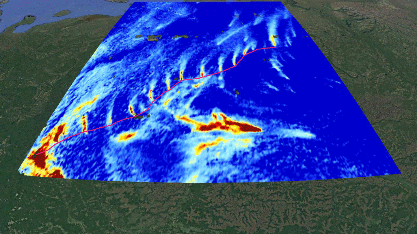
New maps that use information from the Copernicus Sentinel-5P satellite reveal emissions of nitrogen dioxide along a Siberian natural gas pipeline that connects the Urengoy gas field – the second-largest gas field in the world – with Europe.
UNOOSA signs cooperation agreement with the University of Bonn to help Member States leverage space-based information in all phases of disaster management
20.6.2019 10:28 GISCafe.com Webcasts-Webinars VIENNA, 19 June (United Nations Information Service) - The United Nations Office for Outer Space Affairs (UNOOSA) signed a cooperation agreement with …Druhý start Ariane 5 v roce 2019
20.6.2019 9:57 Český Kosmický PortálNosná raketa Ariane 5 vynesla na plánované oběžné dráhy telekomunikační družice T-16 a Eutelsat-7C.
Volná místa v T-Mapách
20.6.2019 7:00 Česká asociace pro geoinformace Společnost T-Mapy, kolektivní člen CAGI, nabízí volná pracovní místa na následující pozice:Správce systému Linux
Vývojář .NET
Vývojář JavaScript
UI Designer
Vývojář
Pozemkové úpravy jako součást akce „Kulatý stůl“
20.6.2019 0:00 Státní pozemkový úřad V rámci projektu s názvem Podpora strategického řízení obcí na území Šternberska se dne 29. 5. 2019 ve společenském sále hostince „Základna u Lípy“ v obci Babice, v okrese Olomouc, uskutečnil diskuzní seminář „Komplexní pozemkové úpravy – teorie a praxe“. Projekt je realizován za podpory Evropského sociálního fondu prostřednictvím Operačního programu Zaměstnanost. V rámci projektu Podpora strategického řízení obcí na území Šternberska jsou pro vybrané obce zpracovány strategické rozvojové dokumenty a pasporty majetku. Kulaté stoly slouží jako neformální platforma pro výměnu zkušeností a dobré praxe.Raytheon and AirMap collaborate on safe drone integration into the national airspace system
19.6.2019 17:08 GISCafe.com Webcasts-Webinars PARIS, June 19, 2019 — (PRNewswire) — Raytheon Company (NYSE: RTN) has signed a strategic agreement with AirMap, the leading …2. pracovník výpravny
19.6.2019 14:02 ČÚZK - předpisy a opatření Katastrální úřad pro hlavní město Prahu zveřejnil novou aktualitu: Ředitel úřadu vyhlašuje výběrové řízení na služební místo:pracovník výpravny
2. odborný referent/vrchní referent – návrh zápisu v katastru
19.6.2019 14:02 ČÚZK - předpisy a opatření Katastrální úřad pro hlavní město Prahu - Katastrální pracoviště Praha zveřejnil novou aktualitu: Ředitel úřadu vyhlašuje výběrové řízení na služební místo:odborný referent/vrchní referent – návrh zápisu v katastru
VŘ - 19.06.2019
19.6.2019 14:02 ČÚZK /Urady/Katastralni-urady/Katastralni-urady/Katastralni-urad-pro-hlavni-mesto-Prahu/O-uradu/Aktuality/VR-19-06-20192. pracovník výpravny
19.6.2019 14:02 ČÚZK /Urady/Katastralni-urady/Katastralni-urady/Katastralni-urad-pro-hlavni-mesto-Prahu/O-uradu/Aktuality/VR-19-06-20192. odborný referent/vrchní referent – návrh zápisu v katastru
19.6.2019 14:02 ČÚZK /Urady/Katastralni-urady/Katastralni-urady/Katastralni-urad-pro-hlavni-mesto-Prahu/O-uradu/Aktuality/VR-19-06-2019VŘ - 19.06.2019
19.6.2019 14:02 ČÚZK - předpisy a opatření Katastrální úřad pro hlavní město Prahu - Katastrální pracoviště Praha zveřejnil novou aktualitu: Ředitel úřadu vyhlašuje výběrové řízení na služební místo:odborný referent/vrchní referent – návrh zápisu v katastru
VŘ - 19.06.2019
19.6.2019 14:02 ČÚZK - předpisy a opatření Katastrální úřad pro hlavní město Prahu - Katastrální pracoviště Praha zveřejnil novou aktualitu: Ředitel úřadu vyhlašuje výběrové řízení na služební místo:odborný referent/vrchní referent – návrh zápisu v katastru
pracovník výpravny
19.6.2019 13:58 ČÚZK - předpisy a opatření Katastrální úřad pro hlavní město Prahuvypisuje výběrové řízení na místo
pracovník výpravny
odborný referent/vrchní referent – návrh zápisu v katastru
19.6.2019 13:58 ČÚZK - volná místa Katastrální úřad pro hlavní město Prahu - Katastrální pracoviště Praha vypisuje výběrové řízení na místo odborný referent/vrchní referent – návrh zápisu v katastrupracovník výpravny
19.6.2019 13:58 ČÚZK /Urady/Katastralni-urady/Katastralni-urady/Katastralni-urad-pro-hlavni-mesto-Prahu/Uredni-deska/Oznameni-a-jina-uredni-sdeleni/Volna-mista/odborny-referent-vrchni-referent-–-navrh-zapisu-vodborný referent/vrchní referent – návrh zápisu v katastru
19.6.2019 13:58 ČÚZK /Urady/Katastralni-urady/Katastralni-urady/Katastralni-urad-pro-hlavni-mesto-Prahu/Uredni-deska/Oznameni-a-jina-uredni-sdeleni/Volna-mista/odborny-referent-vrchni-referent-–-navrh-zapisu-vodborný referent/vrchní referent – návrh zápisu v katastru
19.6.2019 13:58 ČÚZK - předpisy a opatření Katastrální úřad pro hlavní město Prahu - Katastrální pracoviště Prahavypisuje výběrové řízení na místo
odborný referent/vrchní referent – návrh zápisu v katastru
pracovník výpravny
19.6.2019 13:58 ČÚZK - volná místa Katastrální úřad pro hlavní město Prahu vypisuje výběrové řízení na místo pracovník výpravnyKde najít informace o svahových deformacích v ČR
19.6.2019 12:52 GeoBusiness V zákoně o geologických pracích a prováděcích vyhláškách k němu jsou uvedeny právní úpravy shromažďování, vyhodnocování a zpřístupnění informací potřebných pro prevenci svahových deformací ... PřečístProběhl seminář „Den s INSPIRE“
19.6.2019 12:23 CENIA - národní geoportál INSPIRE Dne 12. 6. 2019 proběhl v rámci konference Životní prostředí – prostředí pro život“ seminář Den s INSPIRE organizovaný CENIA, českou informační agenturou životního prostředí. Děkujeme Všem účastníkům za velký zájem a podnětnou diskuzi k jednotlivým prezentacím, které si můžete prohlédnout na níže uvedených odkazech: Novelizace INSPIRE legislativy v ČR Jitka Faugnerová, CENIA, česká informační...Platba kartou
19.6.2019 12:13 ČÚZK - předpisy a opatření Katastrální úřad pro Plzeňský kraj - Katastrální pracoviště Tachovzveřejnil novou aktualitu: Vážení klienti, sdělujeme vám, že od 19.6.2019 je možno na Katastrálním pracovišti Tachov platit poplatky platební kartou.
Platba kartou
19.6.2019 12:13 ČÚZK /Urady/Katastralni-urady/Katastralni-urady/Katastralni-urad-pro-Plzensky-kraj/Katastralni-pracoviste/KP-Tachov/O-uradu/Aktuality/Platba-kartouGalileo ANTEX file updated!
19.6.2019 11:44 European GNSS Agency
The European GNSS Service Centre (GSC) is pleased to announce the publication of the updated GALILEO ANTEX file in the Metadata section of the GSC web portal.
The Galileo ANTEX file includes the Phase Centre Variation (PCV), which is the variation of the electrical phase centre of the antenna with respect to the mean phase centre for a given direction. This file has now been updated to include the Direction-Dependant PCV figures for L9 and L10 Galileo satellites (see Satellite Launch Information section). The updated ANTEX file can be found here.
It takes several months to generate the ANTEX file. The process is not straightforward, as it requires performing complex measurements, as well as thorough post-processing and validation of the obtained data.
Galileo Satellite Metadata
The Galileo Satellite Metadata section (under the Support to Developers tab on the GSC site) contains information about the satellite properties, which is needed to properly implement advanced processing algorithms for precise orbit determination or Precise Point Positioning (PPP).
For further up-to-date information on the Galileo system and its services, visit the European GNSS Service Centre (GSC) website, and the GSC Help Desk is available for any comments or questions related to Galileo.
Media note: This feature can be republished without charge provided the European GNSS Agency (GSA) is acknowledged as the source at the top or the bottom of the story. You must request permission before you use any of the photographs on the site. If you republish, we would be grateful if you could link back to the GSA website (http://www.gsa.europa.eu).
Aktualizace údajů
19.6.2019 11:30 Ústecký kraj V Geoportálu ÚAP Ústeckého kraje byla provedena aktualizace údajů pro poskytovatele České Radiokomunikace a.s. – jev 81, 82.Airbus built SEOSAT/Ingenio is finished and ready for testing
19.6.2019 11:01 GISCafe.com Webcasts-Webinars Madrid, 18 June 2019 – Airbus built SEOSAT/Ingenio, the first Earth observation satellite for the European Space Agency (ESA) and Spanish …
Ortofotomozaika
19.6.2019 9:30
ÚGKK SR
GKÚ na svojom portáli zverejnil ortofotomozaiku zo stredného Slovenska.
ArcRevue 3/2019
19.6.2019 9:16 ARCDATA
Co znamená termín Geospatial Cloud, jak využívá webový GIS společnost ČEZ a jak pomáhá ArcGIS Online při správě veřejného osvětlení v Praze? To jsou jen některá z témat nového čísla časopisu ArcRevue. Dále si v něm můžete přečíst řadu technologických článků o ArcGIS Enterprise, ArcGIS Notebook Serveru, prostředí ArcGIS Hub, aplikaci ArcGIS Excalibur, nové verzi ENVI a nadstavbě ArcGIS LocateXT. K tomu zajímavé tipy a triky a první náhled do nástrojů využívajících strojové učení a deep learning.
Časopis si můžete stáhnout ve formátu PDF.
Červnový Missing Maps mapathon v Praze (pozvánka)
19.6.2019 8:41 GISportal.cz
Přijďte a podpořte práci humanitárních organizací tím, že pomůžete zmapovat místa, která jsou nejvíce ohrožena krizemi. Mapathon společně organizují Lékaři bez hranic a Český červený kříž. Srdečně zveme úplné začátečníky i ty, kdo už mapovat umí. Co se na setkání bude dít? Na Mapathonu budeme společně podle satelitních snímků vytvářet v OpenStreetMap mapu pro týmy Lékařů bez hranic […]
The post Červnový Missing Maps mapathon v Praze (pozvánka) appeared first on GISportal.cz.
Odběrná místa povrchových vod 1984 - 2018
19.6.2019 2:00 Cenia - Katalog metadat ČR - INSPIRE ArcGIS Server služba zpřístupňuje konkrétní výsledky analýz pro jednotlivé odběrové body povrchových vod v České republice v letech 1984-2018.Chemismus povrchových vod
19.6.2019 2:00 Cenia - Katalog metadat ČR - INSPIRE Aplikace mapového serveru zobrazuje konkrétní výsledky analýz pro jednotlivé odběrové body povrchových vod v České republice v letech 1984-2018. Aplikace také podává přehled o plošném chemismu povrchových vod ČR v letech 2007-2010. V tomto období došlo k dramatickému poklesu kyselé depozice a k výraznému zlepšení čištění odpadních vod, tedy hlavních faktorů, ovlivňujících chemismus povrchových toků. Pro vybrané složky jsou znázorněny změny od stavu v letech 1984-1996, tedy doby pravděpodobně nejvyššího znečištění povrchových vod a jejich ovlivnění kyselým deštěm.Změny koncentrací prvků v povrchových vodách (1984 - 2010)
19.6.2019 2:00 Cenia - Katalog metadat ČR - INSPIRE ArcGIS Server služba zobrazuje změny koncentrací v letech 1984 - 2010 pro vybrané prvky, tedy doby pravděpodobně nejvyššího znečištění povrchových vod a jejich ovlivnění kyselým deštěm.Chemismus povrchových vod (2007-2010)
19.6.2019 2:00 Cenia - Katalog metadat ČR - INSPIRE ArcGIS Server služba zpřístupňuje chemismus povrchových vod 2007 - 2010 a změny nejdůležitějších složek od období nejvyšší acidifikace (1984 - 2010).Atwell Welcomes Elise Austin to Lead the GIS Group
19.6.2019 1:04 GISCafe.com Webcasts-Webinars SOUTHFIELD, Mich. — (BUSINESS WIRE) — June 18, 2019 — Atwell, LLC is pleased to welcome Elise Austin as GIS Manager. Based in …Nabídka práce v oblasti územního plánování
19.6.2019 0:00 Geografický ústav MUSpolečnost knesl kynčl architekti s.r.o. hledá zájemce o územní plánování:
- nabízíme spolupráci při zpracování územních plánů obcí a měst
- výhodou je studium v oboru sociální či aplikovaná geografie
- nástup možný ihned
Kontaktni osoba:
Ing. arch. Bohuš Zoubek
architekt, partner
tel.: +420 733 176 923
www.knesl-kyncl.com
Nabídka práce v oblasti územního plánování
19.6.2019 0:00 Geografický ústav MUSpolečnost knesl kynčl architekti s.r.o. hledá zájemce o územní plánování:
- nabízíme spolupráci při zpracování územních plánů obcí a měst
- výhodou je studium v oboru sociální či aplikovaná geografie
- nástup možný ihned
Kontaktní osoba:
Ing. arch. Bohuš Zoubek
architekt, partner
Šumavská 416/15
602 00 Brno
tel.: +420 733 176 923
www.knesl-kyncl.com
Simple GIS Releases Simple Territory Mapper Plugin for Simple GIS Client Application!
18.6.2019 17:31 GISCafe.com Webcasts-Webinars June 18, 2019 -- Simple GIS Software, LLC has announced that it has released Simple Territory Mapper Plugin for its Simple GIS Client desktop GIS …thinkWhere Brings International GIS Knowledge to the University of the Highlands and Islands
18.6.2019 17:30 GISCafe.com Webcasts-Webinars June 18, 2019 - thinkWhere is bringing its extensive knowledge of geographic information systems (GIS) and services to the University of the …Raytheon and Black Sage team to deliver counter-drone tech
18.6.2019 17:29 GISCafe.com Webcasts-Webinars Companies working together to defend against drone incursionsPARIS, June 18, 2019 — (PRNewswire) — Raytheon Company (NYSE: RTN) …
MMC to Attend Shenzhen International UAV EXPO
18.6.2019 17:29 GISCafe.com Webcasts-Webinars SHENZHEN, China, June 17, 2019 — (PRNewswire) — MMC (MicromultiCopter Aviation) is set to attend the 4th Shenzhen International UAV EXPO …Mapy letos byly opravdu pro každého aneb ohlédnutí za konferencí 2019
18.6.2019 15:17 TopGis Ti, kteří již pravidelně jezdí na konferenci „Mapy jsou pro každého“ vědí, že si mají rezervovat čas začátkem června, aby mohli načerpat nejnovější poznatky a trendy napříč světem geoprostorových dat. Letos se tradiční konference konala v hotelu Luna, který leží pouhých 12 km od geografického středu naší vlasti. Nikdo tudíž nebyl cestovatelsky znevýhodněn. A jaká12. ples zeměměřičů
18.6.2019 14:45 Spolek zeměměřičů Brno V sobotu 8. února 2020 se koná v Modrém sále Nové Auly VŠB-TU Ostrava v Ostravě – Porubě 12. ples zeměměřičů. Další informace a objednání vstupenek naleznete od 1. července 2019 na stránkách kgdm.vsb.cz. Těšíme se na setkání v neformálním prostředí.Leica představila ruční laserový skener BLK2Go
18.6.2019 14:44 ZeměměřičSpolečnost Leica Geosystems, patřící do švédského koncernu Hexagon, představila na mezinárodní uživatelské konferenci HxGN LIVE 2019 v Las Vegas novinku. Ruční laserový skener BLK2Go, jenž navazuje na loni uvedený model BLK360, má držadlo, které má usnadnit snímkování během pohybu v prostoru. Zatímco BLK360 je statický skener, tedy postavíte jej uprostřed místnosti a skenujete, s BLK2Go procházíte objektem a průběžně skenujete. […]
The post Leica představila ruční laserový skener BLK2Go appeared first on Zeměměřič.
Plánovaná odstávka služieb ESKN a ZBGIS
18.6.2019 11:00
ÚGKK SR
Dňa 20.06.2019 v čase od 16:00 hod. do 21:00 hod. bude vykonaná plánovaná technická údržba (servisný zásah) IT infraštruktúry rezortu ÚGKK SR. V uvedenom čase nebudú dostupné služby systémov ESKN, ZBGIS a ISGZ.
Za vzniknuté problémy sa vopred ospravedlňujeme.
Kosmonaut ESA Tim Peake se zaměří na vzdělávací aktivity
18.6.2019 9:50 Český Kosmický PortálBritský kosmonaut ESA Tim Peake oznámil, že počínaje 1. říjnem 2019 si vezme dvouleté volno z práce v kosmické agentuře.
Sanjay Gangal interviews Steve Mickley, Executive Director from American Institute of Building Design at SPAR 3D conference
18.6.2019 9:00 GISCafe.com Webcasts-WebinarsWebová aplikace Brno Urban Grid
18.6.2019 8:12 GISportal.cz
Město Brno pokračuje v postupném otevírání dat a tentokrát zvolilo netradiční formu dat agregovaných do pravidelné sítě. Na nově vznikajícím portálu BrnoUrbanGrid.cz jsou postupně zveřejňovány různé datové sady. Těch je nyní k dispozici 50 a reprezentujících demografii, dopravní nehody, kriminalitu, občanskou vybavenost a další. Všechna data jsou agregována do pravidelné čtvercové sítě o velikosti buňky 250x250m a pokrývají […]
The post Webová aplikace Brno Urban Grid appeared first on GISportal.cz.
telefonní ústředna - porucha
18.6.2019 7:33 ČÚZK /Urady/Katastralni-urady/Katastralni-urady/Katastralni-urad-pro-Olomoucky-kraj/O-uradu/Aktuality/telefonni-ustredna-poruchatelefonní ústředna - porucha
18.6.2019 7:33 ČÚZK - předpisy a opatření Katastrální úřad pro Olomoucký kraj zveřejnil novou aktualitu: OZNÁMENÍ:od 18.6.2019 do vyřešení opravy ústředny je telefonní spojení na Katastrálním úřadě pro Olomoucký kraj nedostupné.
Děkujeme za pochopení.
Konference GISPLAN 2019
18.6.2019 7:00 Česká asociace pro geoinformaceČeská asociace pro geoinformace (CAGI) a Vysoká škola regionální rozvoje a Bankovní institut - AMBIS, a.s. Vás srdečně zvou k účasti na 5. ročníku konference GIS v plánování měst a regionů, která se uskuteční v Praze v termínu 19. září 2019 v budově vysoké školy AMBIS: Lindnerova 575/1, Praha 8.
Registorvat se můžete již nyní prostřednictvím weového
Omezení provozu pobočky Tachov
18.6.2019 0:00 Státní pozemkový úřad Z důvodu přerušení dodávky vody bude dne 18. června 2019 omezen provoz Pobočky Tachov, a to dle aktuálního stavu, nejméně v době mezi 8 až 10 hod. Provoz podatelny bude i v této době zajištěn. Děkujeme za pochopení!Fortem Technologies Announces Development of New Addition to DroneHunter® Platform Family: F700 Patriot
17.6.2019 19:23 GISCafe.com Webcasts-Webinars Pleasant Grove, June 14, 2019 (GLOBE NEWSWIRE) -- PLEASANT GROVE, UT - June 14, 2019 - Fortem Technologies, Inc., the leader in airspace …Desert greenery
17.6.2019 16:41 ESA Observing the Earth
Marking World Day to Combat Desertification and Drought, the Copernicus Sentinel-2 mission takes us over west Africa
Odstávka Kontaktního místa v Dačicích
17.6.2019 14:08 ČÚZK - předpisy a opatření Katastrální úřad pro Jihočeský kraj - Katastrální pracoviště Jindřichův Hradeczveřejnil novou aktualitu: Dne 25.06.2019 nebude z technických důvodů otevřeno Kontaktní místo Katastrálního pracoviště Jindřichův Hradec v Dačicích.
Odstávka Kontaktního místa v Dačicích
17.6.2019 14:08 ČÚZK /Urady/Katastralni-urady/Katastralni-urady/Katastralni-urad-pro-Jihocesky-kraj/Katastralni-pracoviste/KP-Jindrichuv-Hradec/O-uradu/Aktuality/Odstavka-Kontaktniho-mista-v-DacicichLooking for a Galileo Masters idea? Take inspiration from past winners!
17.6.2019 10:56 European GNSS Agency
If you are struggling to formulate your idea for consideration in this year’s Galileo Masters, which opened for submissions on May 1, perhaps you could take inspiration from some of the innovative ideas that won the GSA Special Prize in previous editions of the competition. Already have an idea? Then register for this year’s competition here.
Sports applications have featured highly in previous editions of the Galileo Masters. Last year the prize went to Smart Gate, a system designed to measure time precisely during sporting activities – in this case skiing and snowboarding. Using GNSS precise timing combined with radio-frequency identification (RFID) technology, the application provides precise times on ski/snowboard runs, which sportspeople can use to hone their skills and techniques.
Then, in 2013, the GSA Special prize went to JOHAN, an application that also targeted improved sports performance. The JOHAN solution used tiny wearable GNSS receivers to monitor field sports in real-time and enable assessment of players’ performances and the development of new tactics based on players’ capabilities.
Finally, back in 2009 the prize went to Nogago, which leveraged the unique properties of EGNOS in a family of smartphone applications that turned smartphones into outdoor navigation devices targeting various needs: 'Nogago Outdoor' for hiking and trekking, 'Nogago Guide' for sightseeing and pedestrian navigation, and 'Nogago Sport' for running and biking.
Specific societal needs
Other winning solutions in the past have sought to address very specific societal needs. The CENTRIP (ChildrEN TRIp Protector) early warning system, which won the GSA Special Prize in 2017, aimed to help teachers to keep track of young children outdoors. The project combined a lightweight GNSS tracking device installed in a durable bracelet, which is worn by the child, with a geo-fence set up around a specified area, enabling teachers to track the location of each child.
Also addressing a very specific societal need, the winning application in 2012 was 3SOUND - a personal navigation solution based on the integration of acoustic binaural technologies (i.e. 3D sounds) and GNSS technologies. Designed to help vision impaired people navigate using sound cues and augmented satellite navigation signals, the technology could also help emergency services operate in low visibility environments.
Mass market potential
Mass market solutions can potentially generate mass profits, so it is no surprise that solutions with the potential for mass market uptake have featured prominently in the competition. In 2015, the prize went to the KYNEO project, which developed cheap, flexible Galileo and EGNOS-enabled modules that allow ubiquitous positioning data for applications in the Internet of Things – a potentially massive global market.
Then there was the Galileo for ARA project by Elecnor Deimos, which took the prize in 2014 and which also had its eye on the mass market. This innovative concept aimed to develop Galileo modules for the Google ARA modular smartphone concept – a potential game changer for positioning in the mobile phone market.
UAV and navigation
UAVs have featured prominently in winning applications from previous years. In 2016, the Drones2GNSS project combined Galileo’s multi-constellation capacity with unmanned aerial vehicles (UAVs) in an innovative approach that addressed a timeless problem of surveying engineers: positioning accuracy in urban canyons and vegetated areas. Earlier, in 2011, the Catalonian company CATNUV won the prize with a mini-UAV Traffic Collision Avoidance System (TCAS) that uses GPS and EGNOS to allow drones to navigate safely in controlled airspace.
Finally, the 2010 winner of the GSA special prize was the Wikitude Drive system from Austrian company Mobilizy. This application transformed a smartphone into an augmented reality dashboard satnav device, which overlays video captured through the camera with driving instructions. This allows users to drive through their phone, watching the road even while they are looking at directions.
This year’s categories
This year the competition is structured in two class categories– ‘Start-up of the Year’ and ‘Idea of the Year’ - both of which are sponsored by the GSA. In addition to the two general categories, you can also submit your solution to be eligible for one of six special prizes:
- Galileo-Copernicus Synergy Challenge;
- Galileo 5G IoT Challenge;
- DLR Artificial Intelligence Navigation Challenge;
- University Challenge;
- BMVI Special Prize; and
- GNSS Living Lab Prize.
There is also a Regional Challenge, where participants can choose a challenge set by a regional partner from around the world that best matches their business case.
If you would like to learn more about the Galileo-Copernicus Synergy Challenge, then take part in a webinar to be held on 19 July 2019 at 10:00 (CEST) to explore the synergies between these systems and see the potential applications with commercial and societal benefits.
Has the above given you inspiration? Even if your idea is not fully formed, make sure to register now so you can receive information about all the great support activities and additional opportunities that arise throughout the submission phase. Registration is free and available to participants all around the world. To find out more, click here.
Media note: This feature can be republished without charge provided the European GNSS Agency (GSA) is acknowledged as the source at the top or the bottom of the story. You must request permission before you use any of the photographs on the site. If you republish, we would be grateful if you could link back to the GSA website (http://www.gsa.europa.eu).
Pojďte do toho s námi
17.6.2019 9:52 ARCDATARádi bychom našli do našeho týmu posilu na pozici obchodně technický zástupce. Tato pozice je ideální pro ty, co mají chuť lidem přinášet něco smysluplného, umí naslouchat potřebám ostatních a dokážou rychle nastínit funkční řešení.
Pošlete nám svůj životopis na jobs@arcdata.cz pokud máte:
- Vysokoškolské vzdělání technického nebo ekonomického směru.
- Znalosti v oblasti informačních technologií.
- Komunikační schopnosti na dobré úrovni.
- Dobrou znalost anglického jazyka.
- Alespoň základní orientaci v ekonomických a daňových otázkách a právní povědomí.
A pokud vás tato pozice nezaujala, podívejte se i na další možnosti na stránkách kariéry. Případně nás neváhejte oslovit i když zrovna nenajdete vypsanou pozici, kterou hledáte.
Pojďte do toho s námi
17.6.2019 9:52 ARCDATARádi bychom našli do našeho týmu posilu na pozici obchodně technický zástupce. Tato pozice je ideální pro ty, co mají chuť lidem přinášet něco smysluplného, umí naslouchat potřebám ostatních a dokážou rychle nastínit funkční řešení.
Pošlete nám svůj životopis na jobs@arcdata.cz pokud máte:
- Vysokoškolské vzdělání technického nebo ekonomického směru.
- Znalosti v oblasti informačních technologií.
- Komunikační schopnosti na dobré úrovni.
- Dobrou znalost anglického jazyka.
A pokud vás tato pozice nezaujala, podívejte se i na další možnosti na stránkách kariéry. Případně nás neváhejte oslovit i když zrovna nenajdete vypsanou pozici, kterou hledáte.
20190617-VŘ Analytik-programátor-zástup
17.6.2019 9:29 ČÚZK /Aktuality-resort/2019/20190617-VR-Analytik-programator-zastup20190617-VŘ Analytik-programátor-zástup
17.6.2019 9:29 ČÚZK - předpisy a opatření Český úřad zeměměřický a katastrální zveřejnil novou aktualitu: Oznámení o vyhlášení výběrového řízení na obsazení služebního místa Analytik/analytička - programátor/programátorka.CubeWerx to exhibit innovative solutions for data providers at inaugural 2019 GeoIgnite conference in Ottawa
17.6.2019 9:00 GISCafe.com Webcasts-Webinars June 17, 2019 -- CubeWerx, a leader in providing advanced geospatial web services for data providers announced today that it will be exhibiting at …Sanjay Gangal interviews Roel van de Straat , Structural Engineer/VR Expert at Arup at SPAR 3D conference
17.6.2019 9:00 GISCafe.com Webcasts-WebinarsPřerušení provozu Sbírky listin v DP od pátku 21.6.2019 do neděle 23.6.2019
17.6.2019 8:37 ČÚZK /Aplikace-DP-do-KN/Aplikace-DP-do-KN/Archiv-DP/259912Přerušení provozu Sbírky listin v DP od pátku 21.6.2019 do neděle 23.6.2019
17.6.2019 8:37 ČÚZK - předpisy a opatřeníVážení uživatelé, oznamujeme, že z provozních důvodů bude od pátku 21.6.2019 od 17:00 do neděle 23.6.2019 do cca 12:00 kompletní odstávka poskytování dokumentů ze Sbírky listin. Za komplikace tímto způsobené se omlouváme a děkujeme za pochopení.
Přerušení provozu Sbírky listin v DP od pátku 21.6.2019 do neděle 23.6.2019
17.6.2019 8:37 Dálkový přístup k údajům KN ČR Vážení uživatelé, oznamujeme, že z provozních důvodů bude od pátku 21.6.2019 od 17:00 do neděle 23.6.2019 do cca 12:00 kompletní odstávka poskytování dokumentů ze Sbírky listin. Za komplikace tímto způsobené se omlouváme a děkujeme za pochopení.Platby kartou
17.6.2019 8:13 ČÚZK /Urady/Katastralni-urady/Katastralni-urady/Katastralni-urad-pro-Stredocesky-kraj/Katastralni-pracoviste/KP-Rakovnik/O-uradu/Aktuality/Platby-kartouPlatby kartou
17.6.2019 8:13 ČÚZK - předpisy a opatření Katastrální úřad pro Středočeský kraj - Katastrální pracoviště RakovníkPlatby kartou Od 17.6.2019 lze na KP Rakovník platit platebními kartami.
Konference URBIS SMART CITY FAIR 2019 (report)
17.6.2019 8:12 GISportal.cz
Dvoudenní mezinárodní konference URBIS SMART CITY FAIR 2019 představila zástupcům veřejné správy, krajů, měst, obcí a dalším návštěvníkům koncept chytrého města a regionu. Veletrh se odehrával na brněnském výstavišti ve dnech 5. a 6. června 2019. Své úspěchy, novinky a vize v „smart“ oblasti prezentovali jednak představitelé samosprávy z různých míst Evropy, dále také vědci z institutů zabývajících […]
The post Konference URBIS SMART CITY FAIR 2019 (report) appeared first on GISportal.cz.
20190617-GaKO-6-2019
17.6.2019 7:42 ČÚZK - předpisy a opatření Český úřad zeměměřický a katastrální zveřejnil novou aktualitu: Aktuální číslo Geodetického a kartografického obzoru (6/2019) je k dispozici ke stažení.ARCDATA hledají obchodně technického zástupce
17.6.2019 7:00 Česká asociace pro geoinformaceSpolečnost ARCDATA PRAHA, kolektivní člen CAGI, hledá do týmu posilu na pozici obchodně technický zástupce. Tato pozice je ideální pro ty, co mají chuť lidem přinášet něco smysluplného, umí naslouchat potřebám ostatních a dokážou rychle nastínit funkční řešení.
Co je požadováno?
- Vysokoškolské vzdělání technického nebo ekonomického směru.
- Znalosti
Omezení provozu Pobočky Česká Lípa
17.6.2019 0:00 Státní pozemkový úřad Z provozních důvodů bude dne 26. června 2019 mezi 8 a 15 hodinou omezen provoz Pobočky Česká Lípa. Provoz podatelny zůstane bez omezení. Děkujeme za pochopení.Omezení provozu Pobočky Česká Lípa
17.6.2019 0:00 Státní pozemkový úřad Z provozních důvodů bude dne 26. června 2019 mezi 8 a 15 hodinou omezen provoz Pobočky Česká Lípa. Provoz podatelny zůstane bez omezení. Děkujeme za pochopení.Hexagon’s Geospatial Division Adds M.App Enterprise and M.App X to Education Program
16.6.2019 12:48 GISCafe.com Webcasts-Webinars 13 June 2019 -- Hexagon’s Geospatial Division will make its M.App Enterprise and M.App X solutions available through its …Luxembourg Space Agency approves EUR 1 million grant to Kleos Space
16.6.2019 12:38 GISCafe.com Webcasts-Webinars Further project grant funding request approved by Luxembourg Space AgencyAdditional commitment of €1,000,000
Funding toward further …
Červnové mapathony Lékařů bez hranic
16.6.2019 7:00 Česká asociace pro geoinformaceČervnové mapathony Lékařů bez hranic
Přijďte a podpořte práci humanitárních organizací tím, že pomůžete zmapovat místa, která jsou nejvíce ohrožena krizemi. Mapathon společně organizují Lékaři bez hranic a Český červený kříž. Srdečně jsou zváni úplní začatečníci i ti, kdo už mapovat umí.
- 25. června Praha (ČSOB - Výmolova 353/3, 15000 Praha
Setkání APG se Střední průmyslovou školou stavební v Plzni
15.6.2019 9:03 Asociace podnikatelů v geomatice Členové pracovní skupiny pro vzdělávání Denisa Petříková a Václav Čada se koncem května setkali se studenty Střední průmyslové školy stavební v Plzni. Následně se tato pracovní skupina na svém červnovém setkání zaměřila na rozvoj spolupráce i s dalšími středními školami, a proto vznikl čtyřstránkový propagační leták představující činnosti a vize APG studentům. Tyto materiály jsou k dispozici všem členům APG, proto máte-li […]APGEO - SETKÁNÍ APG SE STŘEDNÍ PRŮMYSLOVOU ŠKOLOU STAVEBNÍ V PLZNI
15.6.2019 2:00 Asociace podnikatelů v geomatice Členové pracovní skupiny pro vzdělávání Denisa Petříková a Václav Čada se koncem května setkali se studenty Střední průmAPGEO - DALŠÍCH 200 MILIONŮ KORUN NA POZEMKOVÉ ÚPRAVY
15.6.2019 2:00 Asociace podnikatelů v geomatice V průběhu června se uskutečnila schůzka Martina Hrdličky, předsedy představenstva a Jaroslava Cibulky, výkonného ...Návrh změny zákona: Dvojnásobek za vklad do katastru
15.6.2019 0:53 ZeměměřičNa webu Poslanecké sněmovny ČR je uveřejněn sněmovní tisk 509/0, část č. 1/6 Vl. n. z. kterým se mění některé zákony v oblasti daní – EU. V páté části je uvedena změna zákona o správních poplatcích, která v čl. IX uvádí: V položce 120 přílohy k zákonu č. 634/2004 Sb., o správních poplatcích, ve znění zákona č. 349/2011 Sb., zákona č. 428/2012 Sb. a zákona […]
The post Návrh změny zákona: Dvojnásobek za vklad do katastru appeared first on Zeměměřič.
Innovusion Announces Its High-Resolution Image-Grade LiDAR System “Cheetah”, Enabling the Safest Performance in the Vehicle Mobility Industry
15.6.2019 0:06 GISCafe.com Webcasts-Webinars Industry’s First Proprietary Dual - Rotating Polygon DesignProvides Safest and Most Reliable Detection Available, While Maintaining
…
Dalších 200 milionů korun na pozemkové úpravy
15.6.2019 0:02 Asociace podnikatelů v geomatice V průběhu června se uskutečnila schůzka Martina Hrdličky, předsedy představenstva a Jaroslava Cibulky, výkonného ředitele s Martinem Vrbou, ústředním ředitelem Státního pozemkového úřadu. Jednání přineslo celou řadu pozitivních zpráv: Ministerstvo zemědělství uvolnilo dalších 200 milionů korun na projekty pozemkových úprav, z čehož vyplývá, že nedojde k posunu úhrad za již provedené práce. V průběhu léta 2019 bude vypsáno přibližně […]73. setkání pražských fotogrammetrů a členů SFDP se uskutečnilo v regionálním podzemním výzkumném centru URC Josef dne 4. 6. 2019
14.6.2019 23:39 Společnost pro fotogrammetrii a dálkový průzkumŠtola Josef se nachází v malebné krajině nedaleko Slapské přehrady. Výzkumné práce zde realizuje Centrum experimentální geotechniky (K220). Podrobné informace jsou dostupné na https://ceg.fsv.cvut.cz/o-nas/stola-josef
The post 73. setkání pražských fotogrammetrů a členů SFDP se uskutečnilo v regionálním podzemním výzkumném centru URC Josef dne 4. 6. 2019 appeared first on SFDP.
Jak se české Mapy.cz propojily na Booking.com
14.6.2019 18:48 GeoBusiness České Mapy.cz, které jsou místním 7. nejnavštěvovanějším webem měsíčně s 20 miliony návštěvami, se propojily s globálním serverem Booking.com. Nově uživatelé přímo v mapové ... PřečístVelodyne Features Advanced Lidar for Port Terminal Automation at TOC Europe
14.6.2019 16:17 GISCafe.com Webcasts-Webinars Velodyne Integrator DGWorld Showcases Advanced Vehicle AutomationSAN JOSE, Calif. — (BUSINESS WIRE) — June 14, 2019 —
…
Odborný referent – obnova katastrálního operátu v oddělení dokumentace KN
14.6.2019 15:47 ČÚZK - volná místa Katastrální úřad pro Zlínský kraj - Katastrální pracoviště Valašské Meziříčí vypisuje výběrové řízení na místo Odborný referent – obnova katastrálního operátu v oddělení dokumentace KNOdborný referent – obnova katastrálního operátu v oddělení dokumentace KN
14.6.2019 15:47 ČÚZK - předpisy a opatření Katastrální úřad pro Zlínský kraj - Katastrální pracoviště Valašské Meziříčívypisuje výběrové řízení na místo
Odborný referent – obnova katastrálního operátu v oddělení dokumentace KN
Odborný referent – obnova katastrálního operátu v oddělení dokumentace KN
14.6.2019 15:47 ČÚZK /Urady/Katastralni-urady/Katastralni-urady/Katastralni-urad-pro-Zlinsky-kraj/Uredni-deska/Oznameni-a-jina-uredni-sdeleni/Volna-mista/Odborny-referent-–-obnova-katastralniho-operatu-v
Nové číslo GaKO
14.6.2019 13:00
ÚGKK SR
Nové číslo časopisu Geodetického a Kartografického Obzoru 6/2019
New handheld imaging laser scanner offers unprecedented efficiency to surveyors
14.6.2019 12:38 GISCafe.com Webcasts-Webinars BLK2GO handheld imaging laser scanner is the newest scanner in the Leica Geosystems BLK series(HEERBRUGG, SWITZERLAND/LAS VEGAS, 13 …
GaKO 6/2019
14.6.2019 12:33 GaKO GaKO 6/2019 BARICZOVÁ, G.: Tvorba modelu krovu historickej budovy pre BIM BEITLOVÁ, M.: Analýza kartografické gramotnosti pomocí eye-trackingu"Talking Trash and Saving the Planet at HxGN LIVE in Las Vegas" by Susan Smith
14.6.2019 12:07 GISCafe.com Webcasts-WebinarsNew domain-centric reality capture software brings the best of point cloud processing into one streamlined application
14.6.2019 12:05 GISCafe.com Webcasts-Webinars Leica Cyclone 3DR automates scan-to-deliverable workflows(HEERBRUGG, SWITZERLAND, 13 JUNE 2019) - Leica Geosystems, part of Hexagon, …
Platební karty
14.6.2019 11:47 ČÚZK - předpisy a opatření Katastrální úřad pro Jihomoravský kraj - Katastrální pracoviště Vyškov zveřejnil novou aktualitu: Od 14.6.2019 lze platit správní poplatky a úplaty ve všech typech řízení (V, Z, PÚ, PGP) platební kartou.Platební kartou nelze prozatím platit úplatu za službu sledování změn
Typy akceptovaných platebních karet zde.
Platební karty
14.6.2019 11:47 ČÚZK - předpisy a opatření Katastrální úřad pro Jihomoravský kraj - Katastrální pracoviště Vyškov zveřejnil novou aktualitu: Od 14.6.2019 lze platit správní poplatky a úplaty ve všech typech řízení (V, Z, PÚ, PGP) platební kartou.Platební kartou nelze prozatím platit úplatu za službu sledování změn.
Typy akceptovaných platebních karet zde.
Platební karty
14.6.2019 11:47 ČÚZK /Urady/Katastralni-urady/Katastralni-urady/Katastralni-urad-pro-Jihomoravsky-kraj/Katastralni-pracoviste/KP-Vyskov/O-uradu/Aktuality/Platebni-kartyPlatební karty
14.6.2019 11:45 ČÚZK - předpisy a opatření Katastrální úřad pro Jihomoravský kraj - Katastrální pracoviště Kyjov zveřejnil novou aktualitu: Od 13.6.2019 lze platit správní poplatky a úplaty ve všech typech řízení (V, Z, PÚ, PGP) platební kartou.Platební kartou nelze prozatím platit úplatu za službu sledování změn.
Typy akceptovaných platebních karet zde.
Platební karty
14.6.2019 11:45 ČÚZK /Urady/Katastralni-urady/Katastralni-urady/Katastralni-urad-pro-Jihomoravsky-kraj/Katastralni-pracoviste/KP-Kyjov/O-uradu/Aktuality/Platebni-kartyPlatební karty
14.6.2019 11:45 ČÚZK - předpisy a opatření Katastrální úřad pro Jihomoravský kraj - Katastrální pracoviště Kyjov zveřejnil novou aktualitu: Od 13.6.2019 lze platit správní poplatky a úplaty ve všech typech řízení (V, Z, PÚ, PGP) platební kartou.Platební kartou nelze prozatím platit úplatu za službu sledování změn.
Typy akceptovaných platebních karet zde.
Platební karty
14.6.2019 11:41 ČÚZK /Urady/Katastralni-urady/Katastralni-urady/Katastralni-urad-pro-Jihomoravsky-kraj/Katastralni-pracoviste/KP-Hodonin/O-uradu/Aktuality/Platebni-kartyPlatební karty
14.6.2019 11:41 ČÚZK - předpisy a opatření Katastrální úřad pro Jihomoravský kraj - Katastrální pracoviště Hodonín zveřejnil novou aktualitu: Od 13.6.2019 lze platit správní poplatky a úplaty ve všech typech řízení (V, Z, PÚ, PGP) platební kartou.Platební kartou nelze prozatím platit úplatu za službu sledování změn.
Typy akceptovaných platebních karet zde.
Platební karty
14.6.2019 11:39 ČÚZK - předpisy a opatření Katastrální úřad pro Jihomoravský kraj - Katastrální pracoviště Boskovice zveřejnil novou aktualitu: Od 11.6.2019 lze platit správní poplatky a úplaty ve všech typech řízení (V, Z, PÚ, PGP) platební kartou.Platební kartou nelze prozatím platit úplatu za službu sledování změn.
Typy akceptovaných platebních karet zde.
Platební karty
14.6.2019 11:39 ČÚZK /Urady/Katastralni-urady/Katastralni-urady/Katastralni-urad-pro-Jihomoravsky-kraj/Katastralni-pracoviste/KP-Boskovice/O-uradu/Aktuality/Platebni-kartyPlatební karty
14.6.2019 11:39 ČÚZK - předpisy a opatření Katastrální úřad pro Jihomoravský kraj - Katastrální pracoviště Boskovice zveřejnil novou aktualitu: Od 11.6.2019 lze platit správní poplatky a úplaty ve všech typech řízení (V, Z, PÚ, PGP) platební kartou.Platební kartou nelze prozatím platit úplatu za službu sledování změn.
Typy akceptovaných platebních karet zde.