


![]()

zprávy
zdroje zpráv:odborný rada - právník
21.2.2019 12:56 ČÚZK - předpisy a opatření Katastrální úřad pro hlavní město Prahu - Katastrální pracoviště Prahavypisuje výběrové řízení na služební místo
odborný rada - právník
Aktualizace údajů
21.2.2019 12:03 Ústecký kraj V Geoportálu ÚAP Ústeckého kraje byla, ve vztahu k nabytí účinnosti 3. Aktualizace ZÚR ÚK, aktualizována skupina č. 18 – Zásady územního rozvojeKulatý stůl na téma autonomní doprava a její implikace - české a americké firmy diskutovaly o budoucnosti autonomního řízení
21.2.2019 9:59 Český Kosmický PortálDne 13. února 2019 uspořádalo obchodní oddělení Velvyslanectví USA ve spolupráci s Ministerstvem dopravy setkání zaměřené na problematiku a budoucnost autonomního řízení. Patnáct českých a amerických firem a zástupců veřejného a výzkumného sektoru představilo svoje aktivity a diskutovalo představy a projekty, které souvisí s vývojem technologií pro autonomní řízení, budováním potřebné infrastruktury či rozvojem služeb.
Rada/odborný rada - rozhodování o povolení vkladu RPV1004
21.2.2019 9:45 ČÚZK - předpisy a opatření Katastrální úřad pro Plzeňský kraj - Katastrální pracoviště Plzeň-městovypisuje výběrové řízení na místo
Rada/odborný rada - rozhodování o povolení vkladu RPV1004
Rada/odborný rada - rozhodování o povolení vkladu RPV1004
21.2.2019 9:45 ČÚZK - volná místa Katastrální úřad pro Plzeňský kraj - Katastrální pracoviště Plzeň-město vypisuje výběrové řízení na místo Rada/odborný rada - rozhodování o povolení vkladu RPV1004Rada/odborný rada - rozhodování o povolení vkladu RPV1004
21.2.2019 9:45 ČÚZK /Urady/Katastralni-urady/Katastralni-urady/Katastralni-urad-pro-Plzensky-kraj/Uredni-deska/Oznameni-a-jina-uredni-sdeleni/Volna-mista/Rada-odborny-rada-rozhodovani-o-povoleni-vkladuSimple GIS Software Proudly Releases Simple GIS Client Version 11!
21.2.2019 9:00 GISCafe.com Webcasts-Webinars February 20, 2019 -- Simple GIS Software, LLC has announced that it has released version 11 of its Simple GIS Client Application, a lightweight but …HONEST GUIDE představuje české mapy
21.2.2019 8:12 GISportal.cz
Populární YouTube kanál HONEST GUIDE, jehož cílem je podávat dobré tipy turistům v Česku (a zejména pak návštěvníkům našeho hlavního města), se ve své poslední epizodě zaměřil na nabídku mapových produktů, které jsou pro Prahu k dispozici. Znáte všechny z nich?
The post HONEST GUIDE představuje české mapy appeared first on GISportal.cz.
Přihlásíte své kartografické dílo do soutěže?
21.2.2019 6:02 Zeměměřič Pár dní zbývá do uzávěrky přihlášek soutěže Mapa roku.Jubilejní 25. mezinárodní geodetické dny budou v Bratislavě
21.2.2019 6:02 Zeměměřič Geodeti z Polska, Slovenska a České republiky se v červnu setkají v Bratislavě.Vydané územní plány
21.2.2019 1:00 Cenia - Katalog metadat ČR - INSPIRE Územní plány dostupné na Portálu JUAP ZKINSPIRE stahovací služba - síť profilů sledování jakosti povrchových vod
21.2.2019 1:00 Cenia - Katalog metadat ČR - INSPIRE Vrstva umístění objektů, ve kterých byly prováděny odběry vzorků pro chemické analýzy (pevné matrice): sedimentů, plavenin, bioty - biofilmu, bentických organismů, ryb a denní odběry vzorků pro stanovení množství plavenin. Jedná se o předpřipravená data.Databáze chemického složení srážek
21.2.2019 1:00 Cenia - Katalog metadat ČR - INSPIRE V roce 2017 byla do databáze Informačního systému kvality ovzduší (ISKO) dodána data o chemickém složení atmosférických srážek celkem z 37 lokalit v ČR (14 lokalit, na kterých zajišťuje měření ČGS, 14 ČHMÚ, 7 VÚLHM a 2 HBÚ AV ČR). Dále byla dodána data ze 4 německých lokalit (organizace LfULG) a 6 polských lokalit (organizace GIOS) v příhraničních oblastech. Stanice ČHMÚ a LfULG měří ve většině případů čisté srážky v týdenním intervalu (z měsíčního intervalu na týdenní přešla v roce 1996 v souladu s mezinárodní metodikou EMEP). Dále byly od roku 1997 do roku 2010 prováděny týdenní odběry srážek typu „bulk“ (s blíže nedefinovatelným obsahem prašného spadu) na analýzu těžkých kovů. Od roku 2011 se analýzy těžkých kovů provádějí na stanicích ČHMÚ z čistých srážek, odběry typu „bulk“ byly zrušeny. Na lokalitách ostatních organizací se měří v měsíčních (popř. nepravidelných) intervalech koncentrace ve srážkách typu „bulk“ na volné ploše (popř. pod korunami stromů). Detailní údaje o jednotlivých lokalitách a typech odběrů jsou uvedeny zde http://portal.chmi.cz/files/portal/docs/uoco/isko/grafroc/17groc/gr17cz/tab/tabIX4_CZ.html.Voda jako důležitá součást biocenter
21.2.2019 0:00 Státní pozemkový úřad Biocentra a biokoridory jsou důležitou součástí krajiny. Mohou, ale nemusejí obsahovat různé vodní prvky a řadí se mezi součásti Územního systému ekologické stability (ÚSES). Mezi vodní prvky v biocentrech počítáme vodní toky, tůně, mokřady a malé rybníčky. Existence vodních prvků v biocentrech vytváří podmínky pro vznik druhově pestrého biotopu. Vodní prvky obohacují biocentra o vodní flóru, faunu a napomáhají zadržovat vodu v krajině. Nejjednodušší metodou, jak zajistit v biocentrech vodní prvky, je vhodný výběr stanoviště pro budoucí biocentrum například, lokalita s již existujícím vodním prvkem. Tato varianta však není vždy reálná. Na čtyřech příkladech námi vybudovaných biocenter lze demonstrovat možnosti řešení daného problému.Zajištění vodních prvků v biocentrech
21.2.2019 0:00 Státní pozemkový úřad Mezi vodní prvky v biocentrech počítáme vodní toky, tůně, mokřady a malé rybníčky. Existence vodních prvků v biocentrech vytváří podmínky pro vznik druhově pestrého biotopu. Vodní prvky obohacují biocentra o vodní flóru, faunu a napomáhají zadržovat vodu v krajině. Nejjednodušší metodou, jak zajistit v biocentrech vodní prvky, je vhodný výběr stanoviště pro budoucí biocentrum například, lokalita s již existujícím vodním prvkem. Tato varianta však není vždy reálná. Na čtyřech příkladech námi vybudovaných biocenter lze demonstrovat možnosti řešení daného problému.2019 GeoData Summit Announced
20.2.2019 19:18 GISCafe.com Webcasts-Webinars RSC & DSI to Host GeoData Summit in Alexandria, VA, March 20-21, 2019February 20, 2019 -- Roosevelt Strategic Council and Defense Strategies …
Časopis AUC Geographica na WoS [Katedra aplikované geoinformatiky a kartografie, byTopic]
20.2.2019 17:35 Katedra aplikované geoinformatiky a kartografie Přf UK Náš univerzitní časopis AUC Geographica (Acta Universitatis Carolinae, Geographica), byl nově zařazen do Emerging Sources Citation Index pro výpočet IF. Všechna čísla počínaje 1/2017 jsou tedy již evidována na WoS. Redakční rada děkuje všem přispěvatelům a těm, kteří časopis v minulých letech v jeho rozvoji podporovali.Esri Publishes Switching to ArcGIS Pro from ArcMap
20.2.2019 15:57 GISCafe.com Webcasts-Webinars Workbook Helps to Smooth the Transition between SoftwareApplications
REDLANDS, Calif. — (BUSINESS WIRE) — …
Esri Publishes Switching to ArcGIS Pro from ArcMap
20.2.2019 15:57 GISCafe.com Webcasts-Webinars Workbook Helps to Smooth the Transition between Software Applications
REDLANDS, Calif. — (BUSINESS WIRE) — February 20, 2019 …
Cyient - BlueBird Joint Venture Launches its New Unmanned Aerial System, the Versatile WanderB VTOL at Aero India 2019
20.2.2019 15:57 GISCafe.com Webcasts-Webinars BANGALORE, India and HYDERABAD, India, Feb. 20, 2019 — (PRNewswire) — Cyient Solutions & Systems Pvt. Ltd. (CSS), a joint …Commercial Real Estate simplified: Komreal is the one-stop solution for commercial real estate
20.2.2019 15:57 GISCafe.com Webcasts-Webinars HOUSTON, Feb. 20, 2019 — (PRNewswire) — In commercial real estate, the only real constant is change: trends change, clients change, …14.3.2019
20.2.2019 13:42 ČÚZK - předpisy a opatření Katastrální úřad pro Jihočeský kraj - Katastrální pracoviště České Budějovice zveřejnil novou aktualitu:Ve čtvrtek 14.3.2019 dojde od 7:45 do 10:00 k přerušení dodávky elektrické energie do budovy Katastrálního úřadu v Českých Budějovicích.
Z toho důvodu bude ve čtvrtek 14.3.2019 klientské centrum úřadu (služby podatelny a poskytování údajů z katastru pro geodety) otevřeno pro veřejnost až od 10:00.
14.3.2019
20.2.2019 13:42 ČÚZK /Urady/Katastralni-urady/Katastralni-urady/Katastralni-urad-pro-Jihocesky-kraj/Katastralni-pracoviste/KP-Ceske-Budejovice/O-uradu/Aktuality/14-3-201914.3.2019
20.2.2019 13:40 ČÚZK - předpisy a opatření Katastrální úřad pro Jihočeský kraj zveřejnil novou aktualitu:Ve čtvrtek 14.3.2019 dojde od 7:45 do 10:00 k přerušení dodávky elektrické energie do budovy Katastrálního úřadu v Českých Budějovicích.
Z toho důvodu bude ve čtvrtek 14.3.2019 klientské centrum úřadu (služby podatelny a poskytování údajů z katastru pro geodety) otevřeno pro veřejnost až od 10:00.
14.3.2019
20.2.2019 13:40 ČÚZK /Urady/Katastralni-urady/Katastralni-urady/Katastralni-urad-pro-Jihocesky-kraj/O-uradu/Aktuality/14-3-2019Pozvánka na seminář o možnostech studia v Japonsku
20.2.2019 13:23 Blogující geomatici - FAV ZČU Dovoluji si vás pozvat na seminář o možnostech studia v Japonsku, který se uskuteční 28. 2. od 14:00 v UV115 (budova FST, Univerzitní 22), který bude zajišťovat na půdě ZČU Japonské informační a kulturní centrum (JICC) Velvyslanectví Japonska v ČR.Informace je vyvěšena v aktualitách na http://international.zcu.cz/ a také jako událost na FB International Office:
https://www.facebook.com/events/226516518252062/ dále pak v pozvánkách na https://info.zcu.cz/?rubrika=3
Airbus turns imagery into insight with The OneAtlas Platform
20.2.2019 11:06 GISCafe.com Webcasts-Webinars @AirbusSpace #OneAtlas #Analytics #BigDataToulouse, 19 February 2019 – Airbus Defence and Space has released a brand new version of The …
New digital maps available for 54 countries in the Americas
20.2.2019 10:22 GISCafe.com Webcasts-Webinars Updated and enhanced 2019 GfK map editions for North, South and Central AmericaBruchsal, Germany, February 19, 2019 – GfK has released …
"GISCafe Digital Twin Technology Questionnaire" by Susan Smith
20.2.2019 10:09 GISCafe.com Webcasts-WebinarsVýroční zpráva dle zákona č. 106/1999 Sb. za rok 2018
20.2.2019 9:23 ČÚZK /Urady/Katastralni-urady/Katastralni-urady/Katastralni-urad-pro-Stredocesky-kraj/Vyrocni-zpravy/Vyrocni-zprava-dle-zakona-c-106-1999-Sb-za-rok-(1)Výroční zpráva dle zákona č. 106/1999 Sb. za rok 2018
20.2.2019 9:23 ČÚZK - předpisy a opatření Katastrální úřad pro Středočeský krajvydává výroční zprávu úřadu za rok
2018
20190220 - Plán revizí a OKO novým mapováním v okrese Ústí n.L.
20.2.2019 8:14 ČÚZK /Urady/Katastralni-urady/Katastralni-urady/Katastralni-urad-pro-Ustecky-kraj/Katastralni-pracoviste/KP-Usti-nad-Labem/O-uradu/Aktuality/20190220-Plan-revizi-a-OKO-novym-mapovanim-v-okr20190220 - Plán revizí a OKO novým mapováním v okrese Ústí n.L.
20.2.2019 8:14 ČÚZK - předpisy a opatření Katastrální úřad pro Ústecký kraj - Katastrální pracoviště Ústí nad Labem zveřejnil novou aktualitu: Zveřejňujeme plán revizí a obnovy katastrálního operátu novým mapováním v okrese Ústí nad Labem - dokument ke stažení zde.Aktualizace údajů
20.2.2019 7:36 Ústecký kraj V Geoportálu ÚAP Ústeckého kraje byla provedena aktualizace údajů pro poskytovatele Správa železniční dopravní cesty – jev 70, 73, 75, 78, 80, 81, 82, 94, 95, 97, 105, 119 a Ředitelství silnic a dálnic ČR – jev 90, 93 (zkapacitnění silnice I/27 Most – Litvínov)20190219 - volné místo - Odborný referent v OPV na KP Děčín (zástup za RD max. do 25.1.2020)
20.2.2019 6:45 ČÚZK - předpisy a opatření Katastrální úřad pro Ústecký kraj - Katastrální pracoviště Děčín zveřejnil novou aktualitu: Nabídka volného pacovního místa - Odborný referent v oddělení právních vztahů k nemovitostem na Katastrálním pracovišti Děčín (zástup za rodičovskou dovolenou – max. do 25. 1. 2020)20190219 - volné místo - Odborný referent v OPV na KP Děčín (zástup za RD max. do 25.1.2020)
20.2.2019 6:45 ČÚZK /Urady/Katastralni-urady/Katastralni-urady/Katastralni-urad-pro-Ustecky-kraj/O-uradu/Aktuality/20190219-volne-misto-Odborny-referent-v-OPV-naOdborný referent v oddělení právních vztahů k nemovitostem na Katastrálním pracovišti Děčín (zástup
20.2.2019 6:40 ČÚZK - volná místa Katastrální úřad pro Ústecký kraj - Katastrální pracoviště Děčín vypisuje výběrové řízení na místo Odborný referent v oddělení právních vztahů k nemovitostem na Katastrálním pracovišti Děčín (zástupOdborný referent v oddělení právních vztahů k nemovitostem na Katastrálním pracovišti Děčín (zástup
20.2.2019 6:40 ČÚZK - předpisy a opatření Katastrální úřad pro Ústecký kraj - Katastrální pracoviště Děčínvypisuje výběrové řízení na místo
Odborný referent v oddělení právních vztahů k nemovitostem na Katastrálním pracovišti Děčín (zástup za rodičovskou dovolenou – max. do 25. 1. 2020)
Odborný referent v oddělení právních vztahů k nemovitostem na Katastrálním pracovišti Děčín (zástup
20.2.2019 6:40 ČÚZK /Urady/Katastralni-urady/Katastralni-urady/Katastralni-urad-pro-Ustecky-kraj/Uredni-deska/Oznameni-a-jina-uredni-sdeleni/Volna-mista/Odborny-referent-v-oddeleni-pravnich-vztahu-k-nemoStátní síť imisního monitoringu
20.2.2019 1:00 Cenia - Katalog metadat ČR - INSPIRE Síť imisních měřicích stanic registrovaných v databázi ISKO v roce 2017.Koncentrace látek znečišťujících ovzduší
20.2.2019 1:00 Cenia - Katalog metadat ČR - INSPIRE Koncentrace látek znečišťujících ovzduší v gridu 1x1 km, rok 2017 Imisní limity pro ochranu lidského zdravíSO2 – 4. nejvyšší 24hod. koncentrace SO2 [µg.m-3]PM10 – roční průměrná koncentrace [µg.m-3]PM10 – 36. nejvyšší průměrná 24hod. koncentrace [µg.m-3]PM2.5 – roční průměrná koncentrace [µg.m-3]NO2 – roční průměrná koncentrace [µg.m-3]O3 – 26. nejvyšší maximální denní 8hod. klouzavý průměr koncentrace v průměru za 3 roky, 2015–2017 [µg.m-3]Cd – roční průměrná koncentrace [µg.m-3]As – roční průměrná koncentrace [µg.m-3]Benzo[a]pyren – roční průměrná koncentrace [ng.m-3]Benzen – roční průměrná koncentrace [µg.m-3]Oblasti s překročením imisních limitů bez zahrnutí O3Oblasti s překročením imisních limitů bez zahrnutí Imisní limity pro ochranu ekosystémů a vegetaceO3 – hodnoty expozičního indexu AOT40, průměr za 5 let, 2012–2016 [µg.m-3]NOx – roční průměrná koncentrace [µg.m-3]SO2 – rok a zimní období [µg.m-3]Kvalita ovzduší – imisní databáze
20.2.2019 1:00 Cenia - Katalog metadat ČR - INSPIRE Koncentrace naměřené všemi monitorovacími sítěmi jsou ukládány do imisní databáze ISKO. V databázi jsou archivovány údaje již od počátku měření, koncentrace oxidu siřičitého a suspendovaných částic ze staničních sítí ČHMÚ v severních Čechách a v Praze již od roku 1971. S imisními daty jsou do imisní databáze ukládána i doprovodná meteorologická data, která jsou měřena na velké části automatizovaných imisních stanic ČHMÚ a jsou využívána pro hodnocení imisně-meteorologických vztahů. Imisní databáze ISKO zahrnuje kromě výsledků měření ČHMÚ, které zajišťují pracovníci Imisního monitoringu v centru i na pobočkách, i data poskytovaná spolupracujícími institucemi. Jedná se zejména o zdravotní ústavy, ČEZ, a. s., Výzkumný ústav lesního hospodářství a myslivosti, v.v.i., Českou geologickou službu, Hydrobiologický ústav, městské úřady a další přispěvatele. V databázi jsou též zahrnuty informace z příhraničních oblastí Německa a Polska.Registr emisí a stacionárních zdrojů (REZZO)
20.2.2019 1:00 Cenia - Katalog metadat ČR - INSPIRE Metodický rozvoj a každoroční celorepublikové zpracování a vedení archivu emisní databáze zajišťuje ČHMÚ. V časové řadě počínající rokem 1984 jsou v rámci emisní části ISKO archivovány vykazované roční emisní údaje a doprovodné technické údaje nejvýznamnější skupiny provozoven (dříve REZZO 1). Od 90. let minulého století jsou součástí databáze rovněž údaje zdrojů zařazených předchozí legislativou mezi tzv. střední zdroje znečišťování ovzduší (dříve REZZO 2). Sběr ohlašovaných údajů stacionárních zdrojů, vymezených v příloze č. 2 k zákonu o ochraně ovzduší, je prováděn prostřednictvím Integrovaného systému plnění ohlašovacích povinností, zavedeného zákonem č. 25/2008 Sb. Rozdělení provozoven do kategorií REZZO 1 a REZZO 2 je vytvořeno podle formy ohlášených údajů souhrnné provozní evidence za rok 2016, kde bylo pro cca 42 % hlášení využito tzv. zjednodušené formy (příloha č. 11 vyhlášky č. 415/2012 Sb.).Pro potřeby bilance emisí z lokálního vytápění domácností je od roku 1997 používána metodika založená na údajích ze Sčítání lidu, domů a bytů (SLDB). Údaje ze SLDB jsou každoročně aktualizovány ve spolupráci s regionálními dodavateli paliv a energií. Konečným výstupem modelu jsou údaje o emisích znečišťujících látek a palivové skladbě domácích topenišť na úrovni jednotlivých obcí, které jsou obsaženy v databázi REZZO 3. Vedle lokálního vytápění domácností jsou v databázi REZZO 3 dopočítávány údaje o emisích z dalších stacionárních zdrojů, nevyjmenovaných v příloze č. 2 zákona o ochraně ovzduší, mezi které patří plošné použití rozpouštědel, zemědělské a stavební činnosti. Bilance emisí mobilních zdrojů (REZZO 4) zahrnuje silniční, železniční, vodní a leteckou dopravu a provoz zemědělských, lesních a dalších strojů.Databáze chemického složení srážek
20.2.2019 1:00 Cenia - Katalog metadat ČR - INSPIRE V roce 2017 byla do databáze Informačního systému kvality ovzduší ISKO dodána data o chemickém složení atmosférických srážek celkem ze 48 lokalit (13 lokalit, na kterých zajišťuje měření ČGS, 14 ČHMÚ, 7 VÚLHM a 6 HBÚ AV ČR). Dále byla také dodána data z 4 německých lokalit (organizace LfULG) a 6 polských lokalit (organizace GIOS) v příhraničních oblastech. Stanice ČHMÚ a LfULG měří ve většině případů čisté srážky v týdenním intervalu (z měsíčního intervalu na týdenní přešla v roce 1996 v souladu s mezinárodní metodikou EMEP). Dále byly od roku 1997 do roku 2010 prováděny týdenní odběry srážek typu „bulk“ (s blíže nedefinovatelným obsahem prašného spadu) na analýzu těžkých kovů. Od roku 2011 se analýzy těžkých kovů provádějí na stanicích ČHMÚ z čistých srážek, odběry typu „bulk“ byly zrušeny. Na lokalitách ostatních organizací se měří v měsíčních (popř. nepravidelných) intervalech koncentrace ve srážkách typu „bulk“ na volné ploše (popř. pod korunami stromů). Detailní údaje o jednotlivých lokalitách a typech odběrů jsou uvedeny zde http://portal.chmi.cz/files/portal/docs/uoco/isko/grafroc/17groc/gr17cz/tab/tabIX4_CZ.html.Státní síť imisního monitoringu
20.2.2019 1:00 Cenia - Katalog metadat ČR - INSPIRE Síť imisních měřicích stanic (měřicích programů) registrovaných v databázi ISKO v roce 2017.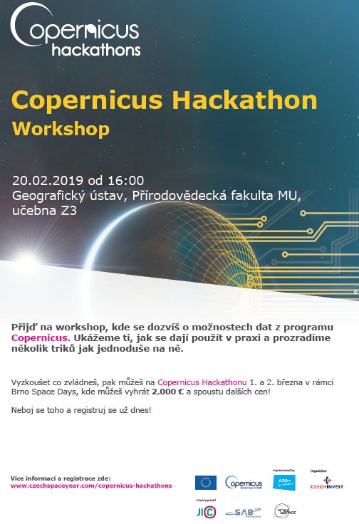
FARO Reports Fourth Quarter and Fiscal Year 2018 Financial Results
19.2.2019 22:32 GISCafe.com Webcasts-Webinars LAKE MARY, Fla., Feb. 19, 2019 — (PRNewswire) — FARO® (NASDAQ: FARO), the world's most trusted source for 3D measurement and …Better designs with digital construction
19.2.2019 20:03 Bentley SystemsPress Coverage
The Geospatial World, India
Read the articleDavid Armstrong presents on Possibility Paradigm Sessions - Digital Twin
19.2.2019 20:01 Bentley SystemsPress Coverage
IMC, USA
Read the articleSiemens and Bentley launch digital twin for DER resources
19.2.2019 19:57 Bentley SystemsPress Coverage
Electric Light & Power, USA
Read the article3D LiDAR Technology Brought to Mass-Market with a $599 Livox Sensor
19.2.2019 18:38 GISCafe.com Webcasts-Webinars Low Cost, Reliable, High Performance Sensors Available NowSHENZHEN, China, Feb. 19, 2019 — (PRNewswire) — Livox is shifting the …
Drone Delivery Canada Unveils Its Largest and Farthest Range Cargo Delivery Drone, The 'Condor'
19.2.2019 18:38 GISCafe.com Webcasts-Webinars TORONTO, Feb. 19, 2019 — (PRNewswire) — Drone Delivery Canada 'DDC or the Company' (TSX.V:FLT, OTC: TAKOF), today unveiled its largest …WINDGO, Inc., ProVector™ 2.0 Measurement and Projection Mapping System Patent Granted
19.2.2019 18:38 GISCafe.com Webcasts-Webinars COLUMBIA, Mo., Feb. 19, 2019 — (PRNewswire) — Today, WINDGO, Inc., a research and development company specializing in smart …Sabrewing Aircraft Company, Inc Takes On $2M+ In Drone-Fund-Led Capital Round To Complete Its Production Prototype Aircraft
19.2.2019 17:07 GISCafe.com Webcasts-Webinars CAMARILLO, Calif., Feb. 19, 2019 (GLOBE NEWSWIRE) -- Sabrewing Aircraft Company, Inc., a startup that has designed and is building an unmanned …Using Drones to Map a Crime Scene
19.2.2019 17:07 GISCafe.com Webcasts-Webinars FoxFury Lighting Solutions and Sundance Media Group host an exercise demonstrating the use of UAV mapping technology in crime scene …Macquarie Capital Venture Studio Announces Commitments in Three InfraTech Companies
19.2.2019 17:07 GISCafe.com Webcasts-Webinars AirMap, Envoy Technologies, and Teralytic join program’s third moduleInfraTech companies drive innovation in infrastructure …
FARO® Introduces FARO RevEng™ for Design Professionals
19.2.2019 17:07 GISCafe.com Webcasts-Webinars Seamless Scan to CAD Software Solution for the FARO® Design ScanArmLAKE MARY, Fla., Feb. 19, 2019 — (PRNewswire) — FARO® (NASDAQ: …
Pointivo Raises Series A Funding of $7 Million Led by BIP Capital
19.2.2019 17:07 GISCafe.com Webcasts-Webinars 3D Intelligence Platform uses artificial intelligence and computer vision to automatically extract 3D objects in a sceneATLANTA, Feb. 19, 2019 …
Hoverfly joins Persistent System's Wave Relay® Ecosystem
19.2.2019 17:07 GISCafe.com Webcasts-Webinars Tethered drone solution provider Hoverfly to incorporate Embedded ModuleNEW YORK, Feb. 19, 2019 — (PRNewswire) — Persistent …
Vrchní referent / rada – rozhodování o povolení vkladu v oddělení právních vztahů k nemovitostem
19.2.2019 16:07 ČÚZK - volná místa Katastrální úřad pro Zlínský kraj - Katastrální pracoviště Uherské Hradiště vypisuje výběrové řízení na místo Vrchní referent / rada – rozhodování o povolení vkladu v oddělení právních vztahů k nemovitostemVrchní referent / rada – rozhodování o povolení vkladu v oddělení právních vztahů k nemovitostem
19.2.2019 16:07 ČÚZK - předpisy a opatření Katastrální úřad pro Zlínský kraj - Katastrální pracoviště Uherské Hradištěvypisuje výběrové řízení na místo
Vrchní referent / rada – rozhodování o povolení vkladu v oddělení právních vztahů k nemovitostem
Vrchní referent / rada – rozhodování o povolení vkladu v oddělení právních vztahů k nemovitostem
19.2.2019 16:07 ČÚZK /Urady/Katastralni-urady/Katastralni-urady/Katastralni-urad-pro-Zlinsky-kraj/Uredni-deska/Oznameni-a-jina-uredni-sdeleni/Volna-mista/Vrchni-referent-rada-–-rozhodovani-o-povoleni-vkrada/odborný rada – obnova katastrálního operátu
19.2.2019 14:14 ČÚZK /Urady/Katastralni-urady/Katastralni-urady/Katastralni-urad-pro-Olomoucky-kraj/Uredni-deska/Oznameni-a-jina-uredni-sdeleni/Volna-mista/rada-odborny-rada-–-obnova-katastralniho-operaturada/odborný rada – obnova katastrálního operátu
19.2.2019 14:14 ČÚZK - předpisy a opatření Katastrální úřad pro Olomoucký kraj - Katastrální pracoviště Prostějovvypisuje výběrové řízení na místo
rada/odborný rada – obnova katastrálního operátu
rada/odborný rada – obnova katastrálního operátu
19.2.2019 14:14 ČÚZK - volná místa Katastrální úřad pro Olomoucký kraj - Katastrální pracoviště Prostějov vypisuje výběrové řízení na místo rada/odborný rada – obnova katastrálního operátuFirst results
19.2.2019 12:39 ESA Observing the Earth
The calibration, validation and science results for ESA’s Aeolus wind mission to be presented at a workshop on 26–29 March. Registration closes 25 February
EGNOS and Galileo for aviation at World ATM Congress
19.2.2019 11:02 European GNSS Agency
The European GNSS Agency (GSA) is organising a workshop on EGNOS and Galileo services for aviation on March 13 as part of the World ATM Congress in Madrid. At the session, a number of speakers will discuss the current status of EGNOS and Galileo implementation in the sector, potential new services and will gather priorities for research and development funding from the sector.
EGNOS currently enables localizer performance with vertical guidance (LPV), the performance-based navigation (PBN) alternative to ILS Cat I, supporting advanced arrival procedures and facilitating Point in Space (PinS) for helicopters. EGNOS positioning also increases the availability of ADS-B (Automatic Dependent Surveillance-Broadcast). Meanwhile, Galileo receivers are included in Search and Rescue beacons and new Galileo services for the aviation community are being explored.
At the workshop, which will take place at 10.10 – 11.10 in the FABEC Conference Room, GSA Market Development Officer and Horizon 2020 Coordinator Carmen Aguilera will provide an update on these and other EGNOS and Galileo services supporting aviation operations now and in the future. The session will also be an opportunity to discuss R&D priorities and new funding opportunities.
Supporting compliance
Christian Belleux, Director at PNT solution provider Orolia will talk at the workshop about how Galileo can help airlines comply with the upcoming European mandate on aircraft distress tracking and the new Standards and Recommended Practices (SARPs) from the International Civil Aviation Organisation (ICAO) relating to the location of an aeroplane in distress.
Read this: Help shape the future of Galileo and EGNOS
These new SARPs relate to Autonomous Distress Tracking (ADT), which is part of the Global Aeronautical Distress and Safety System (GADSS) initiative launched by ICAO, which became effective on 11 July 2016 and will be applicable from 1 January 2021. In Europe, the Rule on ‘location of an aircraft in distress’ – CAT.GEN.MPA.210 covers this ICAO provision and is applicable to large aeroplane manufacturers from Jan 2021 onwards.
Robustness and accuracy
In his presentation at the workshop, Pere Molina, Advanced Applications Programme Manager at GeoNumerics, will highlight how EGNSS (Galileo and EGNOS) can help smooth out drone integration into current and future ATM and UAV traffic management (UTM) concepts.
Drone technology is serving all kinds of professional applications related to the air segment - from inspection, surveillance and surveying, to package delivery and ultimately even passenger transport. These applications are safety- and/or liability-critical and the robustness and accuracy provided by EGNOS and Galileo has a lot to offer in this regard. However, the potential of EGNOS and Galileo are currently underexploited, which is a big missed opportunity, according to Molina.
And this: March 5 deadline approaching for 4th Horizon 2020 EGNSS Call
A representative from the European Satellite Services Provider (ESSP), which specialises in the operation and provision of satellite-based services for aviation, will discuss working with new EGNOS users to enable flying Instrument Flight Rules (IFR) in Visual Flight Rule (VFR) environments. To support the European Aviation Safety Agency’s (EASA) goal of enabling IFR for general aviation, all stakeholders will work together to identify topics that need further assessment and propose solutions where EGNOS can help increase safety levels.
World ATM Congress
Now in its seventh year, this year’s World ATM Congress will take place in IFEMA, Feria de Madrid, on 12-14 March and will bring together the world’s leading product developers, experts, stakeholders, and air navigation service providers (ANSPs) for three days of conference sessions, product demonstrations and launches, and educational and networking opportunities.
For more information, visit the WATM website.
Media note: This feature can be republished without charge provided the European GNSS Agency (GSA) is acknowledged as the source at the top or the bottom of the story. You must request permission before you use any of the photographs on the site. If you republish, we would be grateful if you could link back to the GSA website (http://www.gsa.europa.eu).
UPOZORNĚNÍ - Internet Explorer
19.2.2019 11:00 Středočeský kraj Mapové aplikace s označením logo JS jsou již funkční i ve webovém prohlížeči Internet Explorer. Nefunkčnost způsobila aktualizace pro zabezpečení Microsoft Windonows ze dne 12.02.2019.Odborný referent – obnova katastrálního operátu v oddělení obnovy
19.2.2019 10:56 ČÚZK - předpisy a opatření Katastrální úřad pro Zlínský krajvypisuje výběrové řízení na místo
Odborný referent – obnova katastrálního operátu v oddělení obnovy
Odborný referent – obnova katastrálního operátu v oddělení obnovy
19.2.2019 10:56 ČÚZK /Urady/Katastralni-urady/Katastralni-urady/Katastralni-urad-pro-Zlinsky-kraj/Uredni-deska/Oznameni-a-jina-uredni-sdeleni/Volna-mista/Odborny-referent-–-obnova-katastralniho-operat-(1)Odborný referent – obnova katastrálního operátu v oddělení obnovy
19.2.2019 10:56 ČÚZK - volná místa Katastrální úřad pro Zlínský kraj vypisuje výběrové řízení na místo Odborný referent – obnova katastrálního operátu v oddělení obnovyOdborný rada – vedoucí oddělení aktualizace KN
19.2.2019 10:52 ČÚZK - předpisy a opatření Katastrální úřad pro Zlínský kraj - Katastrální pracoviště Valašské Meziříčívypisuje výběrové řízení na místo
Odborný rada – vedoucí oddělení aktualizace KN
Odborný rada – vedoucí oddělení aktualizace KN
19.2.2019 10:52 ČÚZK - volná místa Katastrální úřad pro Zlínský kraj - Katastrální pracoviště Valašské Meziříčí vypisuje výběrové řízení na místo Odborný rada – vedoucí oddělení aktualizace KNOdborný rada – vedoucí oddělení aktualizace KN
19.2.2019 10:52 ČÚZK /Urady/Katastralni-urady/Katastralni-urady/Katastralni-urad-pro-Zlinsky-kraj/Uredni-deska/Oznameni-a-jina-uredni-sdeleni/Volna-mista/Odborny-rada-–-vedouci-oddeleni-aktualizace-KNIN-FLIGHT Data awarded three GUINNESS WORLD RECORDS™ for groundbreaking Beyond Visual-Line-Of-Sight (BVLOS) project supported by senseFly
19.2.2019 9:55 GISCafe.com Webcasts-Webinars Calgary, Canada / Cheseaux, Switzerland, February 18, 2019 — IN-FLIGHT Data, one of Canada’s leading commercial drone operators, has been …Pozvánka na Copernicus Hackathon
19.2.2019 9:11 GISportal.cz
Pro milovníky družicových dat a netradičních výzev máme tip na akci pořádanou začátkem března. Jako součást Brno Space Days se totiž 1. – 2. 3. 2019 (pátek a sobota) koná jeden z Copernicus hackathonů. Cílem soutěže konané v Tech Nestu je v průběhu 24 hodin vymyslet produkt nebo službu s komerčním potenciálem využívající satelitní data programu Copernicus. […]
The post Pozvánka na Copernicus Hackathon appeared first on GISportal.cz.
Přihlaste se na GISáčka 2019
19.2.2019 8:41 Katedra geoinformatiky UP OlomoucUž jen pár dní zůstává k registraci do soutěže GISáček 2019, kde můžete prezentovat své bakalářské nebo diplomové práce a získat za ně zajímavé odměny. Stačí pouze přihlásit abstrakt své práce a pak jej 20. 3. 2019 v Ostravě prezentovat. Každý aktivní účastník získává mimo jiného i volný vstup na Sympozium GIS Ostrava 2019. Neváhejte […]
The post Přihlaste se na GISáčka 2019 appeared first on Katedra geoinformatiky.
ČHMÚ ovzduší - Síť imisních měřicích programů registrovaných v databázi ISKO v roce 2017
19.2.2019 1:00 Cenia - Katalog metadat ČR - INSPIRE Kompozice obsahuje vrstvu se síťí imisních měřicích stanic a měřicích programů registrovaných v databázi ISKO v roce 2017.Imisní charakteristiky a síť imisních měřicích stanic
19.2.2019 1:00 Cenia - Katalog metadat ČR - INSPIRE Služba byla vytvořena na základě dat ČHMÚ a obsahuje vrstvy:1) Koncentrace látek znečišťujících ovzduší:SO2 – 4. nejvyšší 24hod. koncentrace SO2 [µg.m-3],O3 – hodnoty expozičního indexu AOT40, průměr za 5 let [µg.m-3],O3 – 26. nejvyšší maximální denní 8hod. klouzavý průměr koncentrace přízemního ozonu v průměru za 3 roky [µg.m-3],PM10 – roční průměrná koncentrace [µg.m-3],NO2 – roční průměrná koncentrace [µg.m-3]2) Státní síť imisního monitoringu3) Zóny a aglomerace hodnocení a řízení kvality ovzdušíINSPIRE stahovací služba – Koncentrace látek znečišťujících ovzduší
19.2.2019 1:00 Cenia - Katalog metadat ČR - INSPIRE Koncentrace látek znečišťujících ovzduší v gridu 1x1 km, rok 2017 Imisní limity pro ochranu lidského zdravíSO2 – 4. nejvyšší 24hod. koncentrace SO2 [µg.m-3]PM10 – roční průměrná koncentrace [µg.m-3]PM10 – 36. nejvyšší průměrná 24hod. koncentrace [µg.m-3]PM2.5 – roční průměrná koncentrace [µg.m-3]NO2 – roční průměrná koncentrace [µg.m-3]O3 – 26. nejvyšší maximální denní 8hod. klouzavý průměr koncentrace v průměru za 3 roky, 2015–2017 [µg.m-3]Cd – roční průměrná koncentrace [µg.m-3]As – roční průměrná koncentrace [µg.m-3]Benzo[a]pyren – roční průměrná koncentrace [ng.m-3]Benzen – roční průměrná koncentrace [µg.m-3]Oblasti s překročením imisních limitů bez zahrnutí O3Oblasti s překročením imisních limitů bez zahrnutí Imisní limity pro ochranu ekosystémů a vegetaceO3 – hodnoty expozičního indexu AOT40, průměr za 5 let, 2012–2016 [µg.m-3]NOx – roční průměrná koncentrace [µg.m-3]SO2 – rok a zimní období [µg.m-3]ČHMÚ ovzduší - Imisní charakteristiky v gridu 1x1 km za rok 2017
19.2.2019 1:00 Cenia - Katalog metadat ČR - INSPIRE Kompozice obsahuje Imisní charakteristiky v gridu 1x1 km za rok 2017.Rover ESA pro planetu Mars byl pojmenovaný Rosalind Franklinová
18.2.2019 23:02 Český Kosmický PortálRover ExoMars, který bude pátrat po stavebních kamenech života na Marsu, dostal jméno: Rosalind Franklinová. Významná vědkyně, jejíž práce byla za rozkrytím struktury DNA, tak získá v roce 2021 svoji symbolickou stopu na Marsu.
Rover ESA pro planetu Mars byl pojmenovaný Rosalind Franklinová
18.2.2019 23:02 Český Kosmický PortálRover ExoMars, který bude pátrat po stavebních kamenech života na Marsu, dostal jméno: Rosalind Franklinová. Významná vědkyně, jejíž práce byla za rozkrytím struktury DNA, tak získá v roce 2021 svoji symbolickou stopu na Marsu.
Atomicon – koordinátor projektu GIS – nabídka zaměstnání
18.2.2019 21:15 Společnost Atomicon s.r.o. hledá schopného člověka pro vedení a koordinaci GIS projektů. Součástí náplně práce je řízení malého týmu lidí, organizace práce, komunikace s klienty, firemní agenda, terénní měření s GNSS, realizace zakázek (tvorba mapových výstupů, vývoj vlastní GIS webové aplikace pro obce), atd. Požadavky: Zkušenost s GIS, spolehlivost, samostatnost, komunikativnost, vlastní iniciativu. Důležité je […]Koordinátor/-ka GIS – OLOMOUC
18.2.2019 18:06 Katedra geoinformatiky UP OlomoucPo dlouhé době tady máme ponuku gisáckého pracovního místa v Olomouci! Hledáme schopného člověka pro vedení a koordinaci GIS projektů. Součástí náplně práce je řízení malého týmu lidí, organizace práce, komunikace s klienty, firemní agenda, terénní měření, realizace zakázek atd. Požadujeme: Zkušenost s GIS, spolehlivost, samostatnost, komunikativnost, vlastní iniciativu. Důležité je i příjemné vystupování a […]
The post Koordinátor/-ka GIS – OLOMOUC appeared first on Katedra geoinformatiky.
První start rakety Ariane 5 v roce 2019
18.2.2019 12:51 Český Kosmický PortálNosič Ariane 5 dopravil na plánované oběžné dráhy telekomunikační družice SGS-1/HS-4 a GSAT-31.
První start rakety Ariane 5 v roce 2019
18.2.2019 12:51 Český Kosmický PortálNosič Ariane 5 dopravil na plánované oběžné dráhy telekomunikační družice SGS-1/HS-4 a GSAT-31.
Project Assistant – Knowledge Management – Energy spatial data
18.2.2019 9:09 Joint Research Centre Netherland : We are looking for a person that helps us developing and maintaining a Geographic Information System (GIS) and web GIS platform for visualising, analysing and disseminating energy-related spatial data in support of the EU policy making. Application can be submitted here: https://recruitment.jrc.ec.europa.eu/?site=PTT&type=AX&category=FGIII.Juniper Systems Limited Launches New Cedar CT8 Rugged Tablet
18.2.2019 9:00 GISCafe.com Webcasts-Webinars Fully-Rugged Tablet Provides Global Connectivity, Better PerformanceBirmingham, U.K. – Juniper Systems Limited today announced the release of …
Terra Drone Optimizes Long-Distance Power Line inspection
18.2.2019 9:00 GISCafe.com Webcasts-Webinars Offering power energy distributors in Thailand and Poland 3D power line mapping and detailed tree-trimming reportAkashi-shi, Hyogo, Feb. 19, 2019 …
Výroční souhrnná resortní zpráva za rok 2018
18.2.2019 7:45 ČÚZK - předpisy a opatření Český úřad zeměměřický a katastrálnívydává výroční zprávu úřadu za rok
2018
Výroční zpráva dle zákona č. 106/1999 Sb. za rok 2018
18.2.2019 7:45 ČÚZK - předpisy a opatření Český úřad zeměměřický a katastrálnívydává výroční zprávu úřadu za rok
2018
Volná pozice: Web developer v ARCDATA
18.2.2019 7:00 Česká asociace pro geoinformaceVolná pozice: Web developer v ARCDATA
Máte rádi mapy, moderní mapové aplikace a máte chuť se podílet na rozvoji softwaru, který je vytváří? Chcete pracovat pro leadera na českém i světovém trhu v oblasti geoinformatiky? Chcete být členem dobře fungujícího týmu? Pak Vás rádi poznají v ARCDATA Praha, ve firmě, která je kolektivním členem CAGI hledají posilu do
Ortofotomapa 2005 - WMS a INSPIRE prohlížecí služba
18.2.2019 1:00 Cenia - Katalog metadat ČR - INSPIRE Ortofotomapa 2005 - WMS a INSPIRE prohlížecí službaDigitální model terénu - WMS a INSPIRE prohlížecí služba
18.2.2019 1:00 Cenia - Katalog metadat ČR - INSPIRE Digitální model terénu - WMS a INSPIRE prohlížecí službaDTM pro ortofoto 2005Ortofotomapa 2002 - WMS a INSPIRE prohlížecí služba
18.2.2019 1:00 Cenia - Katalog metadat ČR - INSPIRE Ortotomapa 2002 WMS a INSPIRE prohlížecí službaJDTM ZK - Jednotná digitální technická mapa Zlínského kraje
18.2.2019 1:00 Cenia - Katalog metadat ČR - INSPIRE JDTM ZK - Jednotná digitální technická mapa je složena z Účelové mapy polohopisné situace - ÚMPS (geodeticky měřená uliční čára - polohopis a výškopis v měř. 1:500, systému S-JTSK), která v digitální podobě zobrazuje objekty (např. domy, sloupy, čísla popisná atd.) a průběhů inženýrských sítí, které se na území kraje nacházejí.Neustále průběžně aktualizována.Koncepce a strategie OPK
18.2.2019 1:00 Cenia - Katalog metadat ČR - INSPIRE Koncepce a strategie ochrany přírody a krajiny, Zlínský kraj, 2012Brownfields Zlínského kraje - WMS a prohlížecí služba INSPIRE
18.2.2019 1:00 Cenia - Katalog metadat ČR - INSPIRE Brownfields Zlínského kraje - WMS a prohlížecí služba INSPIRERozptylová studie Zlínského kraje
18.2.2019 1:00 Cenia - Katalog metadat ČR - INSPIRE Rozptylová studie je vytvořena pomocí matematického modelu SYMOS 97 z dat stacionárních zdrojů znečištění z roku 2010. Poskytuje přehled o znečištění ovzduší ve Zlínském kraji.Obraz katastrální mapy
18.2.2019 1:00 Cenia - Katalog metadat ČR - INSPIRE Obraz katastrální mapy Zlínského kraje.Stav dat k 1. 1. 2019. Vznik spojením DKM, KMD, KM-D a ÚKM(orientační mapy parcel - vektorové).Historická ortofoto - WMS a INSPIRE prohlížecí služba
18.2.2019 1:00 Cenia - Katalog metadat ČR - INSPIRE Historická ortofotomapa - WMS služba a INSPIRE prohlížecí službaZáplavová území - WMS a prohlížecí služba INSPIRE
18.2.2019 1:00 Cenia - Katalog metadat ČR - INSPIRE Záplavová území a hlásné profily, WMS a prohlížecí služba INSPIREProtipovodňová opatření - WMS a INSPIRE prohlížecí služba
18.2.2019 1:00 Cenia - Katalog metadat ČR - INSPIRE Protipovodňová opatření - WMS a INSPIRE prohlížecí službaPRVKZK - WMS a INSPIRE prohlížecí služba
18.2.2019 1:00 Cenia - Katalog metadat ČR - INSPIRE Plán rozvoje vodovodů a kanalizací Zlínského kraje WMS a INSPIRE prohlížecí služba"Drivers Snap Street-Level Imagery with Capture Projects from Mapillary" by Susan Smith
17.2.2019 8:41 GISCafe.com Webcasts-WebinarsOrbit GT supports all types UAV imagery on desktop and 3dmapping.cloud
15.2.2019 20:52 GISCafe.com Webcasts-Webinars Lokeren, Belgium, February 15th, 2019 Orbit GT supports all types of UAV imagery in its desktop products and SaaS product …
SiteSee Deploys ContextCapture to Model Communication Towers, and Achieves 98% Recognition Accuracy
15.2.2019 19:56 Bentley SystemsPress Coverage
The Geospatial World, India
Read the articleBentley Institute Press Announces Availability of Practical Foundation Design
15.2.2019 18:06 Bentley SystemsPress Coverage
Daily CADCAM, India
Read the articleIntegrated BIM+geospatial full lifecycle approach for construction
15.2.2019 17:58 Bentley SystemsPress Coverage
The Geospatial World, India
Read the articleSATRIA Technologies Uses Intelligent Design Process to Deliver Control Relay Panels for Malaysian Substation
15.2.2019 17:55 Bentley SystemsPress Coverage
Automation Control, India
Read the articleEarth from Space
15.2.2019 15:45 ESA Observing the Earth
For Valentine’s week, Copernicus Sentinel-2 takes us to one of the most romantic destinations in the world: the Maldives
Otevírací doba v letním semestru [Knihovna geografie, byTopic]
15.2.2019 14:40 Katedra aplikované geoinformatiky a kartografie Přf UK Změna otevírací doby od 18. února 2019Mapová aplikace Správní členění
15.2.2019 12:45 Středočeský kraj V mapové aplikaci Správní členění, v nástroji Seznamu vrstev, byly aktualizovány vrstvy RÚIAN a ISKN (viz skupina vrstev Katastr Nemovitostí a RÚIAN) (stav dat k 01.01.2019 a 31.12.2018). Zároveň byl aktualizován adresář obcí (stav dat k 04.02.2019).Územně plánovací dokumentace - aktualizace
15.2.2019 12:45 Středočeský kraj Mapová aplikace Územně plánovací dokumentace ve Středočeském kraji byla aktualizována. Do nástroje Informace, záložka Reporty byl přidán nový report Nová data (stav ke dni 06.02.2019). Od poslední aktualizace přibylo 119 ÚPD. Celkem je usazeno 589 hlavních a koordinačních výkresů z 1 144 obcí.Trimble TDC100 za nižší cenu
15.2.2019 12:41 Geotronics GIS - Populární terénní pomocníci Trimble TDC100 jsou nyní o 25 % levnější.Pozvánka na konferenciu o využiteľnosti datasetov CORINE Land Cover
15.2.2019 10:08 Geocommunity.skPríspevok Pozvánka na konferenciu o využiteľnosti datasetov CORINE Land Cover zobrazený najskôr GeoCommunity.sk.
Pozvánka na konferenciu o využiteľnosti datasetov CORINE Land Cover
15.2.2019 10:08 Geocommunity.skPríspevok Pozvánka na konferenciu o využiteľnosti datasetov CORINE Land Cover zobrazený najskôr GeoCommunity.sk.
Pozvánka na konferenciu o využiteľnosti datasetov CORINE Land Cover
15.2.2019 10:08 Geocommunity.skPríspevok Pozvánka na konferenciu o využiteľnosti datasetov CORINE Land Cover zobrazený najskôr GeoCommunity.sk.