


![]()

zprávy
zdroje zpráv:Odborný/vrchní referent v oddělení dokumentace katastru nemovitostí na Katastrálním pracovišti Tepli
23.1.2019 9:39 ČÚZK - předpisy a opatření Katastrální úřad pro Ústecký kraj - Katastrální pracoviště Teplicevypisuje výběrové řízení na místo
Odborný/vrchní referent v oddělení dokumentace katastru nemovitostí na Katastrálním pracovišti Teplice (po dobu RD)
Odborný/vrchní referent v oddělení dokumentace katastru nemovitostí na Katastrálním pracovišti Tepli
23.1.2019 9:39 ČÚZK - volná místa Katastrální úřad pro Ústecký kraj - Katastrální pracoviště Teplice vypisuje výběrové řízení na místo Odborný/vrchní referent v oddělení dokumentace katastru nemovitostí na Katastrálním pracovišti TepliCzechTourism představil novou výstavní expozici pro světové veletrhy tvořenou především našimi leteckými fotkami
23.1.2019 9:23 UpVision CzechTourism představil svoji novou výstavní expozici pro světové veletrhy, kterou opět tvoří především naše nové letecké fotografie.Náhled zde:
https://plus.google.com/u/0/b/115833877689730865211/+UpvisionCz1/posts/MQcCEkvHnjL
20190123 Rada/odborný rada – interní auditor Katastrálního úřadu pro Středočeský kraj
23.1.2019 8:25 ČÚZK /Urady/Katastralni-urady/Katastralni-urady/Katastralni-urad-pro-Stredocesky-kraj/O-uradu/Aktuality/20190121-Rada-odborny-rada-oddeleni-podpory-IC-(1)20190123 Rada/odborný rada – interní auditor Katastrálního úřadu pro Středočeský kraj
23.1.2019 8:25 ČÚZK - předpisy a opatření Katastrální úřad pro Středočeský kraj Vyhlášení výběrového řízení: Rada/odborný rada – interní auditor Katastrálního úřadu pro Středočeský kraj V části "Úřední deska", v sekci "Oznámení a jiná úřední sdělení" bylo vystaveno "Oznámení o vyhlášení výběrového řízení na obsazení služebního místa Rada/odborný rada – interní auditor Katastrálního úřadu pro Středočeský kraj"Rada/odborný rada – interní auditor Katastrálního úřadu pro Středočeský kraj
23.1.2019 8:24 ČÚZK /Urady/Katastralni-urady/Katastralni-urady/Katastralni-urad-pro-Stredocesky-kraj/Uredni-deska/Oznameni-a-jina-uredni-sdeleni/Volna-mista/Rada-odborny-rada-–-interni-auditor-KatastralnihoRada/odborný rada – interní auditor Katastrálního úřadu pro Středočeský kraj
23.1.2019 8:24 ČÚZK - volná místa Katastrální úřad pro Středočeský kraj vypisuje výběrové řízení na místo Rada/odborný rada – interní auditor Katastrálního úřadu pro Středočeský kraj20190123 Vrchní referent/rada oddělení aktualizace PI KN I.
23.1.2019 8:09 ČÚZK - předpisy a opatření Katastrální úřad pro Středočeský kraj - Katastrální pracoviště Praha-východ zveřejnil novou aktualitu: Vrchní referent/rada oddělení aktualizace PI KN I. V části "Úřední deska", v sekci "Oznámení a jiná úřední sdělení" bylo vystaveno "Oznámení o vyhlášení výběrového řízení na obsazení služebního místa Vrchní referent/rada oddělení aktualizace PI KN I."20190123 Vrchní referent/rada oddělení aktualizace PI KN I.
23.1.2019 8:09 ČÚZK /Urady/Katastralni-urady/Katastralni-urady/Katastralni-urad-pro-Stredocesky-kraj/Katastralni-pracoviste/KP-Praha-vychod/O-uradu/Aktuality/20180601-(2)OneWeb Satellites has shipped first satellites for the OneWeb constellation to launch site
23.1.2019 8:08 GISCafe.com Webcasts-Webinars Toulouse, France, 22 January 2019 - OneWeb Satellites, a joint venture between Airbus and OneWeb, today announced the delivery of the first …Vrchní referent/rada oddělení aktualizace PI KN I.
23.1.2019 8:07 ČÚZK - předpisy a opatření Katastrální úřad pro Středočeský kraj - Katastrální pracoviště Praha-východvypisuje výběrové řízení na místo Vrchní referent/rada oddělení aktualizace PI KN I.
Vrchní referent/rada oddělení aktualizace PI KN I.
Vrchní referent/rada oddělení aktualizace PI KN I.
23.1.2019 8:07 ČÚZK /Urady/Katastralni-urady/Katastralni-urady/Katastralni-urad-pro-Stredocesky-kraj/Uredni-deska/Oznameni-a-jina-uredni-sdeleni/Volna-mista/Vrchni-referent-rada-oddeleni-aktualizace-PI-KN-IVrchní referent/rada oddělení aktualizace PI KN I.
23.1.2019 8:07 ČÚZK - volná místa Katastrální úřad pro Středočeský kraj - Katastrální pracoviště Praha-východ vypisuje výběrové řízení na místo Vrchní referent/rada oddělení aktualizace PI KN I.Odborný referent / vrchní referent – poskytování informací KN, poskytování podkladů, nahlížení do KN
23.1.2019 7:20 ČÚZK - předpisy a opatření Katastrální úřad pro Zlínský kraj - Katastrální pracoviště Vsetínvypisuje výběrové řízení na místo
Odborný referent / vrchní referent – poskytování informací KN, poskytování podkladů, nahlížení do KN, poskytování informací PK v oddělení dokumentace KN
Odborný referent / vrchní referent – poskytování informací KN, poskytování podkladů, nahlížení do KN
23.1.2019 7:20 ČÚZK - volná místa Katastrální úřad pro Zlínský kraj - Katastrální pracoviště Vsetín vypisuje výběrové řízení na místo Odborný referent / vrchní referent – poskytování informací KN, poskytování podkladů, nahlížení do KNOdborný referent / vrchní referent – poskytování informací KN, poskytování podkladů, nahlížení do KN
23.1.2019 7:20 ČÚZK /Urady/Katastralni-urady/Katastralni-urady/Katastralni-urad-pro-Zlinsky-kraj/Uredni-deska/Oznameni-a-jina-uredni-sdeleni/Volna-mista/Odborny-referent-vrchni-referent-–-poskytovani-iVýroční zpráva dle zákona č. 106/1999 Sb. za rok 2018
23.1.2019 7:10 ČÚZK /Urady/Katastralni-urady/Katastralni-urady/Katastralni-urad-pro-Vysocinu/Vyrocni-zpravy/Vyrocni-zprava-dle-zakona-c-106-1999-Sb-za-rok-2Výroční zpráva dle zákona č. 106/1999 Sb. za rok 2018
23.1.2019 7:10 ČÚZK - předpisy a opatření Katastrální úřad pro Vysočinuvydává výroční zprávu úřadu za rok
2018
CORINE Land Cover 2018 (ATOM)
23.1.2019 1:00 Cenia - Katalog metadat ČR - INSPIRE Předpřipravená datová sada, která obsahuje soubory (CLC18_CZ, CLC12R_CZ a CHA18_CZ) ve formátu SHP archivované do formátu ZIP. Data jsou zpřístupněna prostřednictvím služby ATOM. CLC18_CZ - Databáze s klasifikací pokryvu zemského povrchu v rozsahu ČR v roce 2018. Databáze CLC 2018 byla interpretována z aktualizované databáze CLC 2012. Velikost nejmenší mapovací jednotky pro polygony CLC 2018 je 25 ha.CLC12R_CZ - Revidovaná databáze s klasifikací pokryvu zemského povrchu v rozsahu ČR v roce 2012. V rámci tvorby databáze CLC 2018 byla revidována a aktualizována databáze CLC 2012. Velikost nejmenší mapovací jednotky pro polygony CLC 2012 je 25 ha.CHA18_CZ - Změnová databáze byla odvozena z databáze s klasifikací pokryvu zemského povrchu v roce 2012 vizuálním porovnáním rastrových podkladů z roku 2012 a 2018. Zaznamenány byly všechny změny splňující mapovací kritéria (rozloha > 5 ha, posun hranic > 100 m).Smart city tématem sympozia GIS Ostrava 2019
22.1.2019 19:46 GeoBusiness Organizátoři sympozia GIS Ostrava 2019 uveřejnili témata letošní akce. Geoinformační infrastruktury, DTM Zdroje geodat Dálkový průzkum Země (vč. UAV) Smart city Smart region Smart ... PřečístStudenti, přihlaste svoji práci na konferenci GISáček
22.1.2019 19:34 GeoBusiness Až do 10. března 2019 mohou studenti přihlásit svoji práci do letošního ročníku studentské konference GISáček 2019. Konference GISáček je určená studentům vysokých škol, kteří ... PřečístTémata konference Mapy jsou pro každého 2019
22.1.2019 19:09 GeoBusiness Jak na základě prostorových informací, map a dat efektivně a zodpovědně rozhodovat? V jaké podobě potřebujeme informace pro bezpečná a udržitelná rozhodnutí? Jak inovovat, ... PřečístBAE Systems Expands National Geospatial-Intelligence Agency Mission Support and Establishes New Tech Council to "Map" Agency Innovation
22.1.2019 18:51 GISCafe.com Webcasts-Webinars MCLEAN, Va. — (BUSINESS WIRE) — January 22, 2019 —The National Geospatial-Intelligence Agency (NGA) has awarded BAE
…
Bittium and Esri Join PSTA as Platinum Members
22.1.2019 18:51 GISCafe.com Webcasts-Webinars The Public Safety Technology Alliance (PSTA) is pleased to announce the addition of Bittium, a provider of secure communications solutions, and Esri, …USAA Joins Geospatial Intelligence Center
22.1.2019 16:54 GISCafe.com Webcasts-Webinars Longtime NICB member sees value in approach to disaster responseDES PLAINES, Ill., Jan. 22, 2019 — (PRNewswire) — USAA, one of …
Drone Aviation Concludes Training of U.S. Army Unit on Next-Gen WASP ERS Tactical Aerostat
22.1.2019 16:54 GISCafe.com Webcasts-Webinars JACKSONVILLE, FL, Jan. 22, 2019 (GLOBE NEWSWIRE) -- Drone Aviation Holding Corp. (OTCQB: DRNE) (“Drone Aviation” or the “Company”), a …New Kespry Construction Innovations Further Drive Project Profitability by Enhancing Drone Flight and On-Demand Data Accuracy
22.1.2019 16:54 GISCafe.com Webcasts-Webinars Kespry introduces new capabilities to support construction companies to accurately track and drive project progress, and highlights customer …New financial resources for Copernicus space component
22.1.2019 16:50 ESA Observing the Earth
An amendment to the current Copernicus Agreement has been signed by the EU and ESA, adding €96 million to ESA’s space component budget for the world’s largest environmental monitoring programme: Copernicus.
Konference Mapy jsou pro každého 2019
22.1.2019 16:01 CENIA - národní geoportál INSPIRE Nadace Partnerství pořádá již pátý ročník odborné konference Mapy jsou pro každého, která proběhne v termínu 4 - 5. 6. 2019 v Hotelu Luna na Vysočině. Registrovat se můžete zde. Více informací naleznete na www.giskonference.cz.Konference Mapy jsou pro každého 2019
22.1.2019 16:01 CENIA - národní geoportál INSPIRE Nadace Partnerství pořádá již pátý ročník odborné konference Mapy jsou pro každého, která proběhne v termínu 4 - 5. 6. 2019 v Hotelu Luna na Vysočině. Využijte online registraci za zvýhodněných podmínek a přihlaste i své odborné příspěvky. Více na www.giskonference.cz.Rozpočet úřadu za rok 2019
22.1.2019 15:23 ČÚZK - předpisy a opatření Zeměměřický úřadvystavuje rozpočet úřadu za rok
2019
Rozpočet úřadu za rok 2019
22.1.2019 15:23 ČÚZK /Urady/Zememericky-urad/Rozpocty/Rozpocet-uradu-za-rok-2019Rozpočet úřadu za rok 2019
22.1.2019 15:23 Zeměměřický úřad Zeměměřický úřadvystavuje rozpočet úřadu za rok
2019
20190122 odborný referent/ vrchní referent v oddělení aktualizace PI KN I.
22.1.2019 15:14 ČÚZK - předpisy a opatření Katastrální úřad pro Středočeský kraj - Katastrální pracoviště Praha-východ zveřejnil novou aktualitu: odborný referent/ vrchní referent v oddělení aktualizace PI KN I. V části "Úřední deska", v sekci "Oznámení a jiná úřední sdělení" bylo vystaveno "Oznámení o vyhlášení výběrového řízení na obsazení systemizovaného místa odborný referent/ vrchní referent v oddělení aktualizace PI KN I."20190122 odborný referent/ vrchní referent v oddělení aktualizace PI KN I.
22.1.2019 15:14 ČÚZK /Urady/Katastralni-urady/Katastralni-urady/Katastralni-urad-pro-Stredocesky-kraj/Katastralni-pracoviste/KP-Praha-vychod/O-uradu/Aktuality/20180601-(1)odborný referent/ vrchní referent v oddělení aktualizace PI KN I.
22.1.2019 15:13 ČÚZK - volná místa Katastrální úřad pro Středočeský kraj - Katastrální pracoviště Praha-východ vypisuje výběrové řízení na místo odborný referent/ vrchní referent v oddělení aktualizace PI KN I.odborný referent/ vrchní referent v oddělení aktualizace PI KN I.
22.1.2019 15:13 ČÚZK /Urady/Katastralni-urady/Katastralni-urady/Katastralni-urad-pro-Stredocesky-kraj/Volna-mista/odborny-referent-vrchni-referent-v-oddeleni-aktuaodborný referent/ vrchní referent v oddělení aktualizace PI KN I.
22.1.2019 15:13 ČÚZK - předpisy a opatření Katastrální úřad pro Středočeský kraj - Katastrální pracoviště Praha-východvypisuje výběrové řízení na místo odborný referent/ vrchní referent v oddělení aktualizace PI KN I.
odborný referent/ vrchní referent v oddělení aktualizace PI KN I.
Zveřejnění obsahu informací poskytnutých na žádost dle zákona č. 106/1999 Sb. za rok 2019
22.1.2019 14:27 ČÚZK /Urady/Katastralni-urady/Katastralni-urady/Katastralni-urad-pro-Vysocinu/Casto-hledane-informace/Poskytovani-informaci-106-1999-Sb/Zverejneni-obsahu-informaci-poskytnutych-na-za-(1)/Zverejneni-obsahu-informaci-poskytnutych-na-za-(1)Zveřejnění obsahu informací poskytnutých na žádost dle zákona č. 106/1999 Sb. za rok 2019
22.1.2019 14:27 ČÚZK - předpisy a opatření Katastrální úřad pro Vysočinuzveřejňuje obsah informace poskytnutých na žádost dle zákona č. 106/1999 Sb. za rok
2019
Airbus fellows to join ESA’s ɸ-lab
22.1.2019 14:14 ESA Observing the Earth
ESA’s new Earth observation innovation hub, ɸ-lab, is set to welcome three research fellows from the aerospace industry giant Airbus, to work at the edge of disruptive technologies that monitor Earth’s environment from space.
Rozpočet úřadu za rok 2019
22.1.2019 13:56 ČÚZK - předpisy a opatření Katastrální úřad pro Vysočinuvystavuje rozpočet úřadu za rok
2019
Rozpočet úřadu za rok 2019
22.1.2019 13:56 ČÚZK /Urady/Katastralni-urady/Katastralni-urady/Katastralni-urad-pro-Vysocinu/Rozpocet/Rozpocet-uradu-za-rok-2019Rada / odborný rada – rozhodování o povolení vkladu v oddělení právních vztahů k nemovitostem
22.1.2019 13:29 ČÚZK - předpisy a opatření Katastrální úřad pro Zlínský kraj - Katastrální pracoviště Kroměřížvypisuje výběrové řízení na místo
Rada / odborný rada – rozhodování o povolení vkladu v oddělení právních vztahů k nemovitostem
Rada / odborný rada – rozhodování o povolení vkladu v oddělení právních vztahů k nemovitostem
22.1.2019 13:29 ČÚZK /Urady/Katastralni-urady/Katastralni-urady/Katastralni-urad-pro-Zlinsky-kraj/Uredni-deska/Oznameni-a-jina-uredni-sdeleni/Volna-mista/Rada-odborny-rada-–-rozhodovani-o-povoleni-vkladRada / odborný rada – rozhodování o povolení vkladu v oddělení právních vztahů k nemovitostem
22.1.2019 13:29 ČÚZK - volná místa Katastrální úřad pro Zlínský kraj - Katastrální pracoviště Kroměříž vypisuje výběrové řízení na místo Rada / odborný rada – rozhodování o povolení vkladu v oddělení právních vztahů k nemovitostemInformace o výsledcích kontrol dle § 26 zákona č. 255/2012 Sb. za rok 2018
22.1.2019 10:41 ČÚZK - předpisy a opatření Český úřad zeměměřický a katastrálnívydává informace o výsledcích kontrol dle § 26 zákona č. 255/2012 Sb. za rok
2018
Výroční zpráva dle zákona č. 106/1999 Sb. za rok 2018
22.1.2019 9:57 ČÚZK - předpisy a opatření Katastrální úřad pro Jihočeský krajvydává výroční zprávu úřadu za rok
2018
Výroční zpráva dle zákona č. 106/1999 Sb. za rok 2018
22.1.2019 9:57 ČÚZK /Urady/Katastralni-urady/Katastralni-urady/Katastralni-urad-pro-Jihocesky-kraj/Vyrocni-zpravy/Vyrocni-zprava-dle-zakona-c-106-1999-Sb-za-rok-2Rozpočet úřadu za rok 2019
22.1.2019 8:52 ČÚZK - předpisy a opatření Katastrální úřad pro hlavní město Prahuvystavuje rozpočet úřadu za rok
2019
Rozpočet úřadu za rok 2019
22.1.2019 8:52 ČÚZK /Urady/Katastralni-urady/Katastralni-urady/Katastralni-urad-pro-hlavni-mesto-Prahu/Rozpocet/Rozpocet-uradu-za-rok-2019Trimble Expres 2019 představí trendy v totálních stanicích
22.1.2019 8:01 Zeměměřič Na konferenci je vstup zdarma, představeny budou technologické novinky firmy Trimble.Nejrychlejší 3D laserový skener bude na Leica Tour 2019
22.1.2019 7:01 Zeměměřič Gefos představí novinky a cenové akce na své tradiční Leica Tour 2019.Prezentace z konference State of the map CZ+SK na webu
22.1.2019 7:00 Česká asociace pro geoinformacePrezentace z konference State of the map CZ+SK na webu
Čtvrtý ročník české a slovenské konference o OpenStreetMap, State of the map CZ+SK, se konal ve dnech 2. a 3. listopadu 2019 na FIT VUT v Brně. Na weových stránkách jsou nyní k dispozici prezentace a videa z přednášek.
Čtvrtý ročník české a slovenské konference o OpenStreetMap, State of the map CZ+SK, se konal ve
GIVS 2019 - Přihlašte se za zvýhodněné vložné
22.1.2019 7:00 Česká asociace pro geoinformaceDo 15. března je možné se přihlásit na letošní ročník konference Geoinformace ve veřejné správě za zvýhodněné vložné. V minulých letech však byla často tou dobou kapacita konferenčního sálu již naplněna. Neotálejte proto s registrací a přihlašte se na konferenci prostřednictvím webového formuláře už dnes.
Veškeré další informace naleznete na
Bezplatné používání ArcGISu
22.1.2019 6:51 GeoBusiness Firma Esri oznámila nové možnosti pro vývojáře. Začínajícím dokonce nabízí bezplatné používání ArcGISu. Bezplatný přístup Pokud vaše webová aplikace nebude vytvářet obrat, tak můžete ... Přečíst[Copernicus Academy & Copernicus Relays] summer school, tender and greetings from the CSO
22.1.2019 6:50 Dear members of the Copernicus Academy and representatives of the Copernicus Relays, We would like to share with you two news items: 1. The Summer School “Copernicus for Digital Earth” will take place from 23 June to 4 July 2019 in Salzburg, Austria. It will explore the potential of freely available satellite data with a focus on […]6 years PostDoc Position – TU Vienna – Spatial HCI Lab
22.1.2019 6:49 The Geoinformation Group at TU Vienna in Austria is looking for a Post-Doctoral researcher, starting the earliest possible. We would like you to contribute to our research in the areas of Human-Computer Interaction and Geographic Information Science. The position is not tied to a specific predetermined project. Some of the areas we are interested in are: spatial human-computer interaction, human […]Fully funded PhD position – VGI – Leicester
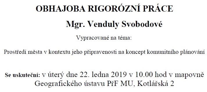
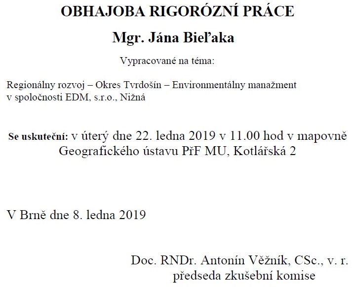
22.1.2019 6:48 Dear all, the University of Leicester is offering a fully funded PhD position to work with me, Dr Nick Tate and Dr Andrea Ballatore (Birkbeck, University of London) on charting the diverse geographies of User-Generated Content. Please see further information below and let me know if you have any questions or queries. Please feel free to forward […]Pozvánka na obhajoby rigorózních prací: P. Marek, V. Svobodová, J. Bieľák
22.1.2019 0:00 Geografický ústav MU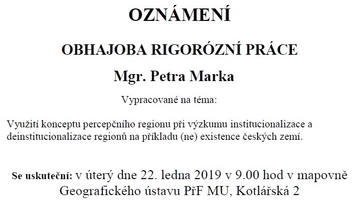
Oznámení o omezení provozu Pobočky Hradec Králové
22.1.2019 0:00 Státní pozemkový úřad Z důvodu přerušení dodávky vody je v úterý 22. 1. 2019 od 11:30 h omezen provoz na PK Hradec Králové (KPÚ pro Královéhradecký kraj).Software pro misi ExoMars prošel zkušebními jízdami
21.1.2019 23:06 Český Kosmický PortálNavigační software určený pro misi ExoMars 2020 prošel zkušebními jízdami, k nimž došlo na „martovské zahrádce“ ESA.
Future City Competition Caries On Last Weekend, Thanks To A Little Help From InterDev
21.1.2019 17:41 GISCafe.com Webcasts-Webinars InterDev helps to secure not only a state-of-the-art competition location but also additional sponsors for the Future City Competition …Média: téma kartografického dne v Olomouci
21.1.2019 15:30 GeoBusiness Všichni zájemci o kartografii jsou zváni na třináctý kartografický den v Olomouci, který se bude konat v pátek 22. února 2019 v budově Přírodovědecké ... PřečístIntroducing the MyGalileoApp Competition
21.1.2019 14:16 European GNSS Agency
The European GNSS Agency’s (GSA) new MyGalileoApp competition challenges developers to design, develop, test and launch a mobile application that takes advantage of the increased accuracy and availability provided by Galileo. The winner stands to win up to EUR 100,000.
Do you have an innovative idea for an application that could benefit from the precise positioning offered by Galileo? Whether it be in the area of augmented reality, geo-marketing, smart navigation, social networking or otherwise – the GSA wants to help you take your idea from concept to reality.
The GSA’s MyGalileoApp Competition challenges developers to design, develop, test and commercially launch a mobile application that provides a position and/or time fix using a Galileo-enabled smartphone equipped with Android /IOS operating system. It must also demonstrate how the increased accuracy/availability provided by Galileo within a multi-constellation/multi-frequency solution adds value to the application.
Each proposed application should target one of the following areas:
- Smart navigation and infotainment
- Augmented reality and games
- Geo marketing and advertising
- Fitness, sport and mHealth
- Enterprise applications
- Social networking
- Mapping, GIS and agriculture
- Automated mobility (all transport modes)
- Aviation
- Drones
- Finance
“The MyGalileoApp Prize will help application developers embrace Galileo’s full potential to create new tools and services,” says Carlo des Dorides, GSA Executive Director. “Through this competition, the GSA is encouraging market adoption of Galileo by supporting the development of mobile applications that address end user needs.”
And did we mention that the winner will receive EUR 100,000?
Interested?
Now that we have your attention, it’s time to get started. To compete, all you have to do is submit a proposal describing how your application addresses one of the 11 development areas, and how it will use Galileo to do so. The deadline for submissions is 28 March 2019. Proposals can be submitted here.
All proposals will be reviewed by GSA experts, who will select a maximum of 30 projects to proceed to the development phase. During this phase, contestants are required to develop a beta version of their app and be able to demonstrate at least 50% functionality. To help, the GSA will provide a dedicated API and online mentoring.
After careful evaluation, the judges will select a maximum of 10 projects to continue to the next phase of the contest. Here, projects must deliver a finalised version of the application with 100% functionality. Those that succeed will be invited to the Finals, where they will present their application to the GSA evaluation board.
Following the presentations, the judges will announce the winners, with the first-place winner receiving a EUR 100,000 prize. The runner up and third place finishers will receive EUR 50,000 and EUR 30,000 respectively.
Let’s talk details…
The MyGalileoApp competition is open to all mobile application developers, entrepreneurs, students, researchers and anybody else who’s up for the challenge (so long as you are at least 18 years of age). You can compete as an individual or a team. All teams are required to appoint a team coordinator, who must be an EU citizen, while other team members can also be from outside the EU. Team members may also represent legal entities as long as this entity has its central administration or registered office in the EU.
At all stages of the contest, projects will be evaluated using the following criteria:
- Innovation: is this kind of solution not yet available on the market? Is the application technologically advanced (e.g. using multi-frequency, innovating algorithms)?
- Market potential: is this solution sellable after repackaging it into a real product? Is there a potential market demand/customer base for this product?
- Galileo-relevance: is the application making use of Galileo? Is the increased accuracy/availability offered by Galileo relevant to the application?
- Technical feasibility: What is the level of progress since the start of the contest? Has the required level of completion for the phase been fully achieved? Is the plan presented for the future of the application (i.e. the scalability and an ensured 18 months of technical support) credible?
More information on the competition will be provided in the course of two webinars, the first of which will be organised on 11 February 2019.
For more details and to register for updates, click here.
Good luck – and we hope to see you at the Finals!
Media note: This feature can be republished without charge provided the European GNSS Agency (GSA) is acknowledged as the source at the top or the bottom of the story. You must request permission before you use any of the photographs on the site. If you republish, we would be grateful if you could link back to the GSA website (http://www.gsa.europa.eu).
Introducing the MyGalileoApp prize contest
21.1.2019 14:16 European GNSS AgencyThe European GNSS Agency’s (GSA) new MyGalileoApp prize contest challenges developers to design, develop, test and launch a mobile application that takes advantage of the increased accuracy and availability provided by Galileo. The winner stands to win up to EUR 100,000.
Do you have an innovative idea for an application that could benefit from the precise positioning offered by Galileo? Whether it be in the area of augmented reality, geo-marketing, smart navigation, social networking or otherwise – the GSA wants to help you take your idea from concept to reality.
The GSA’s MyGalileoApp Prize Contest challenges developers to design, develop, test and commercially launch a mobile application that provides a position and/or time fix using a Galileo-enabled smartphone equipped with Android /IOS operating system. It must also demonstrate how the increased accuracy/availability provided by Galileo within a multi-constellation/multi-frequency solution adds value to the application.
Each proposed application should target one of the following areas:
- Smart navigation and infotainment
- Augmented reality and games
- Geo marketing and advertising
- Fitness, sport and mHealth
- Enterprise applications
- Social networking
- Mapping, GIS and agriculture
- Automated mobility (all transport modes)
- Aviation
- Drones
- Finance
“The MyGalileoApp Prize will help application developers embrace Galileo’s full potential to create new tools and services,” says Carlo des Dorides, GSA Executive Director. “Through this contest, the GSA is encouraging market adoption of Galileo by supporting the development of mobile applications that address end user needs.”
And did we mention that the winner will receive EUR 100,000?
Interested?
Now that we have your attention, it’s time to get started. To compete, all you have to do is submit a proposal describing how your application addresses one of the 11 development areas, and how it will use Galileo to do so. The deadline for submissions is 28 March 2019. Proposals can be submitted here.
All proposals will be reviewed by GSA experts, who will select a maximum of 30 projects to proceed to the development phase. During this phase, contestants are required to develop a beta version of their app and be able to demonstrate at least 50% functionality. To help, the GSA will provide a dedicated API and online mentoring.
After careful evaluation, the judges will select a maximum of 10 projects to continue to the next phase of the contest. Here, projects must deliver a finalised version of the application with 100% functionality. Those that succeed will be invited to the Finals, where they will present their application to the GSA evaluation board.
Following the presentations, the judges will announce the winners, with the first-place winner receiving a EUR 100,000 prize. The runner up and third place finishers will receive EUR 50,000 and EUR 30,000 respectively.
Let’s talk details…
The MyGalileoApp contest is open to all mobile application developers, entrepreneurs, students, researchers and anybody else who’s up for the challenge (so long as you are at least 18 years of age). You can compete as an individual or a team. All teams are required to appoint a team coordinator, who must be an EU citizen, while other team members can also be from outside the EU. Team members may also represent legal entities as long as this entity has its central administration or registered office in the EU.
At all stages of the contest, projects will be evaluated using the following criteria:
- Innovation: is this kind of solution not yet available on the market? Is the application technologically advanced (e.g. using multi-frequency, innovating algorithms)?
- Market potential: is this solution sellable after repackaging it into a real product? Is there a potential market demand/customer base for this product?
- Galileo-relevance: is the application making use of Galileo? Is the increased accuracy/availability offered by Galileo relevant to the application?
- Technical feasibility: What is the level of progress since the start of the contest? Has the required level of completion for the phase been fully achieved? Is the plan presented for the future of the application (i.e. the scalability and an ensured 18 months of technical support) credible?
More information on the contest will be provided in the course of two webinars, the first of which will be organised on 11 February 2019.
For more details and to register for updates, click here.
Good luck – and we hope to see you at the Finals!
Media note: This feature can be republished without charge provided the European GNSS Agency (GSA) is acknowledged as the source at the top or the bottom of the story. You must request permission before you use any of the photographs on the site. If you republish, we would be grateful if you could link back to the GSA website (http://www.gsa.europa.eu).
Introducing the MyGalileoApp prize contest
21.1.2019 14:16 European GNSS AgencyThe European GNSS Agency’s (GSA) new MyGalileoApp prize contest challenges developers to design, develop, test and launch a mobile application that takes advantage of the increased accuracy and availability provided by Galileo. The winner stands to win up to EUR 100,000.00.
Do you have an innovative idea for an application that could benefit from the precise positioning offered by Galileo? Whether it be in the area of augmented reality, geo-marketing, smart navigation, social networking or otherwise – the GSA wants to help you take your idea from concept to reality.
The GSA’s MyGalileoApp Prize Contest challenges developers to design, develop, test and commercially launch a mobile application that provides a position and/or time fix using a Galileo-enabled smartphone equipped with Android /IOS operating system. It must also demonstrate how the increased accuracy/availability provided by Galileo within a multi-constellation/multi-frequency solution adds value to the application.
Each proposed application should target one of the following areas:
- Smart navigation and infotainment
- Augmented reality and games
- Geo marketing and advertising
- Fitness, sport and mHealth
- Enterprise applications
- Social networking
- Mapping, GIS and agriculture
- Automated mobility (all transport modes)
- Aviation
- Drones
- Finance
“The MyGalileoApp Prize will help application developers embrace Galileo’s full potential to create new tools and services,” says Carlo des Dorides, GSA Executive Director. “Through this contest, the GSA is encouraging market adoption of Galileo by supporting the development of mobile applications that address end user needs.”
And did we mention that the winner will receive EUR 100,000.00?
Interested?
Now that we have your attention, it’s time to get started. To compete, all you have to do is submit a proposal describing how your application addresses one of the 11 development areas, and how it will use Galileo to do so. The deadline for submissions is 28 March 2019. Proposals can be submitted here.
All proposals will be reviewed by GSA experts, who will select a maximum of 30 projects to proceed to the development phase. During this phase, contestants are required to develop a beta version of their app and be able to demonstrate at least 50% functionality. To help, the GSA will provide a dedicated API and online mentoring.
After careful evaluation, the judges will select a maximum of 10 projects to continue to the next phase of the contest. Here, projects must deliver a finalised version of the application with 100% functionality. Those that succeed will be invited to the Finals, where they will present their application to the GSA evaluation board.
Following the presentations, the judges will announce the winners, with the first-place winner receiving a EUR 100,000.00 prize. The runner up and third place finishers will receive EUR 50,000.00 and EUR 30,000.00 respectively.
Let’s talk details…
The MyGalileoApp contest is open to all mobile application developers, entrepreneurs, students, researchers and anybody else who’s up for the challenge (so long as you are at least 18 years of age). You can compete as an individual or a team. All teams are required to appoint a team coordinator, who must be an EU citizen, while other team members can also be from outside the EU. Team members may also represent legal entities as long as this entity has its central administration or registered office in the EU.
At all stages of the contest, projects will be evaluated using the following criteria:
- Innovation: is this kind of solution not yet available on the market? Is the application technologically advanced (e.g. using multi-frequency, innovating algorithms)?
- Market potential: is this solution sellable after repackaging it into a real product? Is there a potential market demand/customer base for this product?
- Galileo-relevance: is the application making use of Galileo? Is the increased accuracy/availability offered by Galileo relevant to the application?
- Technical feasibility: What is the level of progress since the start of the contest? Has the required level of completion for the phase been fully achieved? Is the plan presented for the future of the application (i.e. the scalability and an ensured 18 months of technical support) credible?
More information on the contest will be provided in the course of two webinars, the first of which will be organised on 11 February 2019. For more details and to register for updates, click here.
Good luck – and we hope to see you at the Finals!
Media note: This feature can be republished without charge provided the European GNSS Agency (GSA) is acknowledged as the source at the top or the bottom of the story. You must request permission before you use any of the photographs on the site. If you republish, we would be grateful if you could link back to the GSA website (http://www.gsa.europa.eu).
Odborný referent/vrchní referent v oddělení obnovy katastrálního operátu (03020) technického útvaru
21.1.2019 12:25 ČÚZK - volná místa Katastrální úřad pro Královéhradecký kraj vypisuje výběrové řízení na místo Odborný referent/vrchní referent v oddělení obnovy katastrálního operátu (03020) technického útvaruOdborný referent/vrchní referent v oddělení obnovy katastrálního operátu (03020) technického útvaru
21.1.2019 12:25 ČÚZK - předpisy a opatření Katastrální úřad pro Královéhradecký krajvypisuje výběrové řízení na místo
Odborný referent/vrchní referent v oddělení obnovy katastrálního operátu (03020) technického útvaru Katastrálního úřadu pro Královéhradecký kraj
Odborný referent/vrchní referent v oddělení obnovy katastrálního operátu (03020) technického útvaru
21.1.2019 12:25 ČÚZK /Urady/Katastralni-urady/Katastralni-urady/Katastralni-urad-pro-Kralovehradecky-kraj/Volna-mista/Odborny-referent-vrchni-referent-v-oddeleni-obnovyAktualizace údajů
21.1.2019 12:14 Ústecký kraj V Geoportálu ÚAP Ústeckého kraje byla provedena aktualizace údajů pro poskytovatele Česká telekomunikační infrastruktura a.s. – jev 73, 81, 82Firma Thales Alenia Space povede stavbu mise za tajemstvím fotosyntézy
21.1.2019 12:05 Český Kosmický PortálESA uzavřela nový kontrakt s firmou Thales Alenia Space, která tak bude stát v čele konsorcia stavějícího novou misi věnující se výzkumu fotosyntézy: FLEX.
Odborný referent/vrchní referent v oddělení dokumentace KN na Katastrálním pracovišti Hodonín
21.1.2019 10:43 ČÚZK - předpisy a opatření Katastrální úřad pro Jihomoravský kraj - Katastrální pracoviště Břeclavvypisuje výběrové řízení na místo
Odborný referent/vrchní referent v oddělení dokumentace KN na Katastrálním pracovišti Hodonín
Odborný referent/vrchní referent v oddělení dokumentace KN na Katastrálním pracovišti Hodonín
21.1.2019 10:43 ČÚZK - volná místa Katastrální úřad pro Jihomoravský kraj - Katastrální pracoviště Břeclav vypisuje výběrové řízení na místo Odborný referent/vrchní referent v oddělení dokumentace KN na Katastrálním pracovišti HodonínOdborný referent/vrchní referent v oddělení dokumentace KN na Katastrálním pracovišti Břeclav
21.1.2019 10:43 ČÚZK /Urady/Katastralni-urady/Katastralni-urady/Katastralni-urad-pro-Jihomoravsky-kraj/Uredni-deska/Oznameni-a-jina-uredni-sdeleni/Volna-mista/Odborny-referent-vrchni-referent-v-oddeleni-dokumeOdborný referent/vrchní referent v oddělení dokumentace KN na Katastrálním pracovišti Hodonín
21.1.2019 10:43 ČÚZK /Urady/Katastralni-urady/Katastralni-urady/Katastralni-urad-pro-Jihomoravsky-kraj/Uredni-deska/Oznameni-a-jina-uredni-sdeleni/Volna-mista/Odborny-referent-vrchni-referent-v-oddeleni-dokumeOdborný referent/vrchní referent v oddělení dokumentace KN na Katastrálním pracovišti Břeclav
21.1.2019 10:43 ČÚZK - volná místa Katastrální úřad pro Jihomoravský kraj - Katastrální pracoviště Břeclav vypisuje výběrové řízení na místo Odborný referent/vrchní referent v oddělení dokumentace KN na Katastrálním pracovišti BřeclavOdborný referent/vrchní referent v oddělení dokumentace KN na Katastrálním pracovišti Břeclav
21.1.2019 10:43 ČÚZK - předpisy a opatření Katastrální úřad pro Jihomoravský kraj - Katastrální pracoviště Břeclavvypisuje výběrové řízení na místo
Odborný referent/vrchní referent v oddělení dokumentace KN na Katastrálním pracovišti Břeclav
Odborný referent – Oddělení aktualizace katastru nemovitostí
21.1.2019 10:16 ČÚZK - předpisy a opatření Katastrální úřad pro Karlovarský kraj - Katastrální pracoviště Sokolovvypisuje výběrové řízení na místo
Odborný referent – Oddělení aktualizace katastru nemovitostí
Odborný referent – Oddělení aktualizace katastru nemovitostí
21.1.2019 10:16 ČÚZK /Urady/Katastralni-urady/Katastralni-urady/Katastralni-urad-pro-Karlovarsky-kraj/Uredni-deska/Oznameni-a-jina-uredni-sdeleni/Volna-mista/Odborny-referent-–-Oddeleni-aktualizace-katastru-nOdborný referent – Oddělení aktualizace katastru nemovitostí
21.1.2019 10:16 ČÚZK - volná místa Katastrální úřad pro Karlovarský kraj - Katastrální pracoviště Sokolov vypisuje výběrové řízení na místo Odborný referent – Oddělení aktualizace katastru nemovitostí20190121 Vrchní referent/rada oddělení obnovy katastrálního operátu
21.1.2019 10:10 ČÚZK - předpisy a opatření Katastrální úřad pro Středočeský kraj Vyhlášení výběrového řízení: Vrchní referent/rada oddělení obnovy katastrálního operátu V části "Úřední deska", v sekci "Oznámení a jiná úřední sdělení" bylo vystaveno oznámení o vyhlášení výběrového řízení na obsazení služebního místa "Vrchní referent/rada oddělení obnovy katastrálního operátu 03120 Technické sekce"20190121 Vrchní referent/rada oddělení obnovy katastrálního operátu
21.1.2019 10:10 ČÚZK /Urady/Katastralni-urady/Katastralni-urady/Katastralni-urad-pro-Stredocesky-kraj/O-uradu/Aktuality/20190121-Vrchni-referent-rada-oddeleni-obnovy-kataVyhlášení 21. ročníku soutěže Mapa roku
21.1.2019 10:07 GISportal.cz
Autoři a producenti kartografických děl, která byla vytvořena a publikována na území České republiky v roce 2018 a splňují pravidla soutěže, mohou své produkty přihlásit do 28. února 2019 do soutěže Mapa roku. Následně je zhodnotí odborná komise České kartografické společnosti pro soutěž Mapa roku. Slavnostní vyhlášení výsledků soutěže proběhne ve čtvrtek 9. května 2019 od […]
The post Vyhlášení 21. ročníku soutěže Mapa roku appeared first on GISportal.cz.
Vyhlášení 21. ročníku soutěže Mapa roku
21.1.2019 10:07 GISportal.czAutoři a producenti kartografických děl, která byla vytvořena a publikována na území České republiky v roce 2018 a splňují pravidla soutěže, mohou své produkty přihlásit do 28. února 2019 do soutěže Mapa roku. Následně je zhodnotí odborná komise České kartografické společnosti pro soutěž Mapa roku. Slavnostní vyhlášení výsledků soutěže proběhne ve čtvrtek 9. května 2019 od […]
The post Vyhlášení 21. ročníku soutěže Mapa roku appeared first on GISportal.cz.
Vrchní referent/rada oddělení obnovy katastrálního operátu
21.1.2019 10:04 ČÚZK /Urady/Katastralni-urady/Katastralni-urady/Katastralni-urad-pro-Stredocesky-kraj/Uredni-deska/Oznameni-a-jina-uredni-sdeleni/Volna-mista/Vrchni-referent-rada-oddeleni-obnovy-katastralnihoVrchní referent/rada oddělení obnovy katastrálního operátu
21.1.2019 10:04 ČÚZK - předpisy a opatření Katastrální úřad pro Středočeský kraj - technická sekcevypisuje výběrové řízení na místo Vrchní referent/rada oddělení obnovy katastrálního operátu
Vrchní referent/rada oddělení obnovy katastrálního operátu
Vrchní referent/rada oddělení obnovy katastrálního operátu
21.1.2019 10:04 ČÚZK - volná místa Katastrální úřad pro Středočeský kraj - technická sekce vypisuje výběrové řízení na místo Vrchní referent/rada oddělení obnovy katastrálního operátu20190121 Rada/odborný rada oddělení podpory ICT – informatik
21.1.2019 9:58 ČÚZK /Urady/Katastralni-urady/Katastralni-urady/Katastralni-urad-pro-Stredocesky-kraj/O-uradu/Aktuality/20190121-Rada-odborny-rada-oddeleni-podpory-ICT-–20190121 Rada/odborný rada oddělení podpory ICT – informatik
21.1.2019 9:58 ČÚZK - předpisy a opatření Katastrální úřad pro Středočeský kraj Vyhlášení výběrového řízení: Rada/odborný rada oddělení podpory ICT – informatik V části "Úřední deska", v sekci "Oznámení a jiná úřední sdělení" bylo vystaveno "Oznámení o vyhlášení výběrového řízení na obsazení služebního místa Rada/odborný rada oddělení podpory ICT – informatik"Rada/odborný rada oddělení podpory ICT – informatik
21.1.2019 9:56 ČÚZK - předpisy a opatření Katastrální úřad pro Středočeský krajvypisuje výběrové řízení na místo Rada/odborný rada oddělení podpory ICT – informatik
Rada/odborný rada oddělení podpory ICT – informatik
Rada/odborný rada oddělení podpory ICT – informatik
21.1.2019 9:56 ČÚZK - volná místa Katastrální úřad pro Středočeský kraj vypisuje výběrové řízení na místo Rada/odborný rada oddělení podpory ICT – informatik20190121 Rada/odborný rada oddělení právních vztahů k nemovitostem
21.1.2019 9:50 ČÚZK - předpisy a opatření Katastrální úřad pro Středočeský kraj - Katastrální pracoviště Kladno Vyhlášení výběrového řízení: Rada/odborný rada oddělení právních vztahů k nemovitostem V části "Úřední deska", v sekci "Oznámení a jiná úřední sdělení" bylo vystaveno "Oznámení o vyhlášení výběrového řízení na obsazení služebního místa Rada/odborný rada oddělení právních vztahů k nemovitostem"20190121 Rada/odborný rada oddělení právních vztahů k nemovitostem
21.1.2019 9:50 ČÚZK /Urady/Katastralni-urady/Katastralni-urady/Katastralni-urad-pro-Stredocesky-kraj/Katastralni-pracoviste/KP-Kladno/O-uradu/Aktuality/20190121-Rada-odborny-rada-oddeleni-pravnich-vztah20190121 Rada/odborný rada oddělení právních vztahů k nemovitostem
21.1.2019 9:47 ČÚZK /Urady/Katastralni-urady/Katastralni-urady/Katastralni-urad-pro-Stredocesky-kraj/O-uradu/Aktuality/20190121-Rada-odborny-rada-oddeleni-pravnich-vztah20190121 Rada/odborný rada oddělení právních vztahů k nemovitostem
21.1.2019 9:47 ČÚZK - předpisy a opatření Katastrální úřad pro Středočeský kraj - Katastrální pracoviště Kladno Vyhlášení výběrového řízení: Rada/odborný rada oddělení právních vztahů k nemovitostem V části "Úřední deska", v sekci "Oznámení a jiná úřední sdělení" bylo vystaveno "Oznámení o vyhlášení výběrového řízení na obsazení služebního místa Rada/odborný rada oddělení právních vztahů k nemovitostem"Rada/odborný rada oddělení právních vztahů k nemovitostem
21.1.2019 9:45 ČÚZK - předpisy a opatření Katastrální úřad pro Středočeský kraj - Katastrální pracoviště Kladnovypisuje výběrové řízení na místo Rada/odborný rada oddělení právních vztahů k nemovitostem
Rada/odborný rada oddělení právních vztahů k nemovitostem
Rada/odborný rada oddělení právních vztahů k nemovitostem
21.1.2019 9:45 ČÚZK - volná místa Katastrální úřad pro Středočeský kraj - Katastrální pracoviště Kladno vypisuje výběrové řízení na místo Rada/odborný rada oddělení právních vztahů k nemovitostemBridgestone Europe To Acquire TomTom Telematics For €910 Million Cash Consideration
21.1.2019 9:00 GISCafe.com Webcasts-Webinars TomTom Telematics, a business unit of TomTom, is the Europeanleader in digital fleet solutions with a strong data platform.
…
World Ocean Council Ceo To Join Norway Prime Minister In Speaking On Ocean Health And Blue Growth
21.1.2019 8:33 GISCafe.com Webcasts-Webinars Paul Holthus, WOC CEO, To Participate in Panel Led by Prime Minister Solberg at Arctic Frontiers Conference21 January 2019 -- Norway’s …
World Geospatial Industry Council [WGIC] and buildingSMART International sign an MOU to work towards a common initiative in respect of use of standards, best practices and geospatial information
21.1.2019 8:21 GISCafe.com Webcasts-Webinars 16th January 2019 -- A collaboration to enhance the usage of BIM standards in civil infrastructure and to link it to location-based technologies has …Tématem letošního kartografického dne budou média
21.1.2019 6:01 Zeměměřič Média a kartografie. Téma 13. kartografického dne v OlomouciSoutěž Mapa roku: Přihlaste své kartografické dílo
20.1.2019 22:14 GeoBusiness Česká kartografická společnost v roce 2019 pořádá 21. ročník soutěže Mapa roku. Autoři a producenti kartografických děl, která byla vytvořena a publikována na území České ... Přečíst"GISCafe Industry Predictions for 2019 – Part III" by Susan Smith
20.1.2019 10:11 GISCafe.com Webcasts-WebinarsPřihlaste své kartografické dílo do soutěže Mapa roku
20.1.2019 9:01 Zeměměřič Také letos se můžete přihlásit se svým kartografickým dílem do soutěže Mapa rokuSetkání s prezidentem Svazu podnikatelů ve stavebnictví
20.1.2019 8:54 Asociace podnikatelů v geomatice Člen představenstva APG Jaroslav Kocián a výkonný ředitel APG Jaroslav Cibulka představili asociaci a přínos geomatiků pro stavebnictví novému prezidentu SPS Jiřímu Nouzovi a generálnímu řediteli SPS Pavlu Ševčíkovi. Nový prezident SPS Jiří Nouza nahradil po 14 letech ve funkci Václava Matyáše, který zůstává nadále členem představenstva svazu a v pozici poradce nového prezidenta se bude podílet na zajištění kontinuity […]APGEO - SETKÁNÍ S PREZIDENTEM SVAZU PODNIKATELŮ VE STAVEBNICTVÍ
20.1.2019 1:00 Asociace podnikatelů v geomatice Člen představenstva APG Jaroslav Kocián a výkonný ředitel APG Jaroslav Cibulka představili asociaci a přínos geomatiků .Seminář ke geoportálu Inspire
19.1.2019 7:00 Česká asociace pro geoinformaceSeminář ke geoportálu Inspire
CENIA, česká informační agentura životního prostředí, Vás zve na seminář ke sběru uživatelských požadavků pro nový Geoportál INSPIRE, který se bude konat dne 3. 12. 2019 od 10:00 do 12:30 v budově Ministerstva životního prostředí, Vršovická 1442/65, Praha 10, místnost 900.
Body k diskuzi:
Aktuální geoportál z pohledu uživatele
Paradigm Imaging Group Now Offers More Than 60 Scanner Models From 6 Different Manufacturers
18.1.2019 23:48 GISCafe.com Webcasts-Webinars Costa Mesa, CA – January 18, 2019 – Paradigm Imaging Group, a leading distributor of large format scanners, printers, multifunction …AQUAOSO™ Launches Free Digital Water Map for California
18.1.2019 19:09 GISCafe.com Webcasts-Webinars Helping the agricultural economy to better identify water related risksFOLSOM, Calif., Jan. 18, 2019 — (PRNewswire) — AQUAOSO™ …
Natural Gas District & GIS-Centric Asset Management
18.1.2019 19:07 GISCafe.com Webcasts-Webinars January 18, 2019 -- Lake Apopka Natural Gas District (LANGD), servicing the needs of West Central Florida since 1959, has approximately 22,000 …20190118-Statistické údaje za rok 2018
18.1.2019 13:40 ČÚZK - předpisy a opatření Český úřad zeměměřický a katastrální zveřejnil novou aktualitu: Zveřejněny statistické údaje za rok 2018 o vybraných transakcích s nemovitostmi evidovanými v KN.20190118-Statistické údaje za rok 2018
18.1.2019 13:40 ČÚZK /Aktuality-resort/2019/20190118-Statisticke-udaje-za-rok-201820190118-Statistické údaje za rok 2018
18.1.2019 13:40 ČÚZK /Aktuality-resort/20190118-Statisticke-udaje-za-rok-201820190118-Statistické údaje za rok 2018
18.1.2019 13:40 ČÚZK - předpisy a opatření Český úřad zeměměřický a katastrální zveřejnil novou aktualitu: Zveřejněny statistické údaje za rok 2018 o vybraných transakcích s nemovitostmi evidovanými v KN.20190118 - volné místo - Personalistka v personálním odělení na Katastrálním úřadu pro Ústecký kraj
18.1.2019 13:33 ČÚZK /Urady/Katastralni-urady/Katastralni-urady/Katastralni-urad-pro-Ustecky-kraj/O-uradu/Aktuality/20190118-volne-misto-Personalistka-v-personaln20190118 - volné místo - Personalistka v personálním odělení na Katastrálním úřadu pro Ústecký kraj
18.1.2019 13:33 ČÚZK - předpisy a opatření Katastrální úřad pro Ústecký kraj zveřejnil novou aktualitu: Nabídka volného pracovního místa - Personalistka v personálním oddělení na Katastrálním úřadu pro Ústecký kraj (zástup za RD do 1.11.2019)Personalistka v personálním oddělení na Katastrálním úřadu pro Ústecký kraj (zástup za RD do 1.11.20
18.1.2019 13:29 ČÚZK - předpisy a opatření Katastrální úřad pro Ústecký kraj - kancelář úřaduvypisuje výběrové řízení na místo
Personalistka v personálním oddělení na Katastrálním úřadu pro Ústecký kraj (zástup za RD do 1.11.2019)