


![]()

zprávy
zdroje zpráv:KIST: Enhancing Flight Duration Time of Drones with Lithium Metal Ion Batteries!
12.11.2018 18:40 GISCafe.com Webcasts-Webinars - Lithium Metal Ion Battery has been developed which exhibits twicethe energy density that of conventional Lithium-Ion battery -
…
ConnexiCore Partners with Cape For End-to-End Drone Integration and Intelligence
12.11.2018 18:40 GISCafe.com Webcasts-Webinars Partnership delivers enhanced value through aerial telepresence, real-time video streaming, drone data collection and analysis and moreREDWOOD CITY, …
Donan Partners With Matterport For 3D Scans On Fire Losses
12.11.2018 18:40 GISCafe.com Webcasts-Webinars State-of-the-art technology will advance Donan fire investigations.LOUISVILLE, Ky., Nov. 12, 2018 — (PRNewswire) — Donan, an …
3D Systems' Gentle Giant Studios Launches Juggernaut Mobile Studios - Transforming Photogrammetry Workflow for the Entertainment Industry
12.11.2018 18:40 GISCafe.com Webcasts-Webinars - Mobile photogrammetry system delivers enhanced scan quality 96% faster than traditional workflowROCK HILL, S.C., Nov. 12, 2018 — …
ɸ-week kicks off
12.11.2018 18:20 ESA Observing the Earth
With satellites delivering a mindboggling amount of data about our planet along with the availability of the latest digital technologies, there are countless opportunities for innovation. ESA’s ɸ-week, which kicked off today, explores how this new world can be embraced to bring even more benefits to all.
Vernisáž výstavy 3D rekonstrukce středověkého Ostrovského kláštera [Katedra aplikované geoinformatiky a kartografie, byTopic]
12.11.2018 17:45 Katedra aplikované geoinformatiky a kartografie Přf UK Katedra aplikované geoinformatiky a kartografie si pozvat Vás na vernisáž výstavy 3D rekonstrukce středověkého Ostrovského kláštera. V rámci vernisáže bude prezentován unikátní 3D model rekonstrukce zaniklého Ostrovského kláštera, který byl vytvořen pomocí nejmodernějších 3D geoinformačních technologií. Prezentace modelu se koná v Praze na Přírodovědecké fakultě UK, Albertov 6 v učebně Levá rýsovna, dne 20.11.2018 v 16:30.Bentley Systems Announces the Acquisition of ACE enterprise Slovakia, Provider of Enterprise Software Interoperability
12.11.2018 17:19 Bentley SystemsExtends scope of infrastructure engineering digital twins beyond IoT, to include IT
Bentley Systems Incorporated, the leading global provider of comprehensive software solutions for advancing the design, construction, and operations of infrastructure, today announced the acquisition of ACE enterprise Slovakia, provider of innovative technology solutions to interface with enterprise resource planning (ERP), enterprise asset management (EAM), and geographical information systems (GIS). ACE enterprise has been a technology partner of Bentley Systems, and the ACE Enterprise Platform is used for the Bentley AssetWise connector that is certified for both SAP ERP and SAP HANA.
Alexander Cimbalak, founder of ACE enterprise, said, “We have enjoyed our partnership with Bentley to provide enterprise connectors and are very excited to be part of Bentley and also now to enable Bentley’s digital twin cloud services to uniquely synchronize with infrastructure assets’ enterprise IT, OT, and ET data sources.”
Alan Kiraly, senior vice president, asset performance for Bentley Systems, said, “ACE enterprise has consistently overcome IT interoperability challenges for us at Bentley. Now, as colleagues, this talented team will enable us to continue to expand the scope and breadth of information that can be accessed through AssetWise and digitally aligned within infrastructure digital twins.”
About ACE enterprise Slovakia
ACE enterprise Slovakia is an innovative provider of interoperability and mobile solutions for industrial users. They have developed the ACE Enterprise Platform, which enables quick, visual development and configuration of interoperability solutions. ACE enterprise Slovakia has provided solutions to interface with ERP and EAM systems for automotive, manufacturing, mining, oil and gas, and utilities. The company was established in 2003 and is headquartered in Bratislava, Slovakia. www.ace-eprise.com
About Bentley Systems
Bentley Systems is the leading global provider of software solutions to engineers, architects, geospatial professionals, constructors, and owner-operators for the design, construction, and operations of infrastructure. Bentley’s MicroStation-based engineering and BIM applications, and its digital twin cloud services, advance the project delivery (ProjectWise) and the asset performance (AssetWise) of transportation and other public works, utilities, industrial and resources plants, and commercial and institutional facilities.
Bentley Systems employs more than 3,500 colleagues, generates annual revenues of $700 million in 170 countries, and has invested more than $1 billion in research, development, and acquisitions since 2012. From inception in 1984, the company has remained majority-owned by its five founding Bentley brothers. Bentley shares transact by invitation on the NASDAQ Private Market; strategic partner Siemens AG has accumulated a non-voting minority stake. www.bentley.com
Image and caption:
Greg Bentley, CEO, Bentley Systems announced the acquisition of ACE enterprise Slovakia, provider of enterprise software interoperability.
##
Bentley, the Bentley logo, AssetWise, MicroStation, and ProjectWise are either registered or unregistered trademarks or service marks of Bentley Systems, Incorporated or one of its direct or indirect wholly owned subsidiaries. All other brands and product names are trademarks of their respective owners.
Bentley Systems Announces the Acquisition of ACE enterprise Slovakia, Provider of Enterprise Software Interoperability
12.11.2018 17:19 Bentley SystemsExtends scope of infrastructure engineering digital twins beyond IoT, to include IT
Bentley Systems Incorporated, the leading global provider of comprehensive software solutions for advancing the design, construction, and operations of infrastructure, today announced the acquisition of ACE enterprise Slovakia, provider of innovative technology solutions to interface with enterprise resource planning (ERP), enterprise asset management (EAM), and geographical information systems (GIS). ACE enterprise has been a technology partner of Bentley Systems, and the ACE Enterprise Platform is used for the Bentley AssetWise connector that is certified for both SAP ERP and SAP HANA.
Alexander Cimbalak, founder of ACE enterprise, said, “We have enjoyed our partnership with Bentley to provide enterprise connectors and are very excited to be part of Bentley and also now to enable Bentley’s digital twin cloud services to uniquely synchronize with infrastructure assets’ enterprise IT, OT, and ET data sources.”
Alan Kiraly, senior vice president, asset performance for Bentley Systems, said, “ACE enterprise has consistently overcome IT interoperability challenges for us at Bentley. Now, as colleagues, this talented team will enable us to continue to expand the scope and breadth of information that can be accessed through AssetWise and digitally aligned within infrastructure digital twins.”
About ACE enterprise Slovakia
ACE enterprise Slovakia is an innovative provider of interoperability and mobile solutions for industrial users. They have developed the ACE Enterprise Platform, which enables quick, visual development and configuration of interoperability solutions. ACE enterprise Slovakia has provided solutions to interface with ERP and EAM systems for automotive, manufacturing, mining, oil and gas, and utilities. The company was established in 2003 and is headquartered in Bratislava, Slovakia.www.ace-eprise.com
About Bentley Systems
Bentley Systems is the leading global provider of software solutions to engineers, architects, geospatial professionals, constructors, and owner-operators for the design, construction, and operations of infrastructure. Bentley’s MicroStation-based engineering and BIM applications, and its digital twin cloud services, advance the project delivery (ProjectWise) and the asset performance (AssetWise) of transportation and other public works, utilities, industrial and resources plants, and commercial and institutional facilities.
Bentley Systems employs more than 3,500 colleagues, generates annual revenues of $700 million in 170 countries, and has invested more than $1 billion in research, development, and acquisitions since 2012. From inception in 1984, the company has remained majority-owned by its five founding Bentley brothers. Bentley shares transact by invitation on the NASDAQ Private Market; strategic partner Siemens AG has accumulated a non-voting minority stake. www.bentley.com
Image and caption:
Greg Bentley, CEO, Bentley Systems announced the acquisition of ACE enterprise Slovakia, provider of enterprise software interoperability.
##
Bentley, the Bentley logo, AssetWise, MicroStation, and ProjectWise are either registered or unregistered trademarks or service marks of Bentley Systems, Incorporated or one of its direct or indirect wholly owned subsidiaries. All other brands and product names are trademarks of their respective owners.
Nové středisko ESA přináší družicovou navigaci do služeb vědy
12.11.2018 17:10 Český Kosmický PortálGlobální družicové navigační systémy nepřetržitě zaplavují Zemi svými signály. Tyto nejenže zlepšují naše životy, ale zároveň představují nástroj pro špičkovou vědu. Nové zařízení nacházející se v astronomickém středisku ESA nedaleko Madridu je využívá ke všemu možnému: od monitorování Země až po studium základů fyziky.
Bentley Systems Announces Agreement to Acquire AIworx, Specialists in Machine Learning and IoT Technologies
12.11.2018 16:35 Bentley SystemsLeveraging digital twins’ analytics visibility for infrastructure asset performance
Bentley Systems Incorporated, the leading global provider of comprehensive software solutions for advancing the design, construction, and operations of infrastructure, today announced it has entered an agreement to acquire Quebec City-based AIworx, Inc., provider of machine learning and internet of things (IoT) technologies and services. The addition of AIworx brings advancements in data collection and analysis to leverage infrastructure engineering digital twins, continuously updated with real-time contextual information, to optimize productivity, operations, and maintenance.
Andre Villemaire, co-founder and president of AIworx, said, “AIworx has been providing machine learning and IoT technologies and services to help organizations generate, understand, and act on data so they can make better business decisions. The biggest opportunities we’ve worked on have to do with improving infrastructure asset performance on an industrial scale, by way of the data from connected machines, instrumentation, sensors, and communications systems—and we’re excited to dedicate ourselves to that advancement. Now, by incorporating our tools into Bentley’s services for digital twins, we enable infrastructure operators to multiply the potential benefits of machine learning and IoT.”
Francois Valois, vice president of portfolio development for Bentley Systems, said, “Machine learning and IoT technologies have created the opportunity for profound improvements in productivity and efficiency of infrastructure. Our new colleagues from AIworx have already been delivering on this potential, and now, leveraging the analytics visibility, which Bentley’s digital twin cloud services uniquely provide, these advancements from going digital will accelerate exponentially!”
About AIworx
Since 2011, AIworx has been simplifying innovation by providing artificial intelligence and sensor technologies and services for the industrial, aerospace, and defense sectors. www.aiworx.com
About Bentley Systems
Bentley Systems is the leading global provider of software solutions to engineers, architects, geospatial professionals, constructors, and owner-operators for the design, construction, and operations of infrastructure. Bentley’s MicroStation-based engineering and BIM applications, and its digital twin cloud services, advance the project delivery (ProjectWise) and the asset performance (AssetWise) of transportation and other public works, utilities, industrial and resources plants, and commercial and institutional facilities.
Bentley Systems employs more than 3,500 colleagues, generates annual revenues of $700 million in 170 countries, and has invested more than $1 billion in research, development, and acquisitions since 2012. From inception in 1984, the company has remained majority-owned by its five founding Bentley brothers. Bentley shares transact by invitation on the NASDAQ Private Market; strategic partner Siemens AG has accumulated a non-voting minority stake. www.bentley.com
Image and Caption:
AIworx machine learning and IoT technologies leverage digital twins’ analytics visibility for infrastructure asset performance.
##
Bentley, the Bentley logo, AssetWise, MicroStation, and ProjectWise are either registered or unregistered trademarks or service marks of Bentley Systems, Incorporated or one of its direct or indirect wholly owned subsidiaries. All other brands and product names are trademarks of their respective owners.
Talking ɸ
12.11.2018 16:25 ESA Observing the Earth
With ESA’s ɸ-week underway in Italy, Director General, Jan Wörner, talks about what ɸ means to him
Digital Twin Support and Open Source Promised at Bentley Conference
12.11.2018 15:40 Bentley SystemsPress Coverage
ENR, USA
Read the articleJosef Aschbacher on Φ-week
12.11.2018 15:30 ESA Observing the Earth
The availability of today’s wealth of satellite data coupled with the latest digital technologies not only offer unprecedented opportunities for monitoring our changing planet, but they also lay a new landscape for innovation and business. In an interview, ESA’s Director of Earth Observation Programmes, Josef Aschbacher, explains how his concept of Φ, pronounced ‘fee’, is set to exploit this golden age and how he hopes the Φ-week event, being held on 12–16 November 2018 in Italy, will further launch new ideas.
A tale of BIM4D and two iconic buildings in the heart of London's financial district
12.11.2018 15:26 Bentley SystemsPress Coverage
Between the Poles, USA
Read the articleBentley goes open source for its digital twin products
12.11.2018 15:24 Bentley SystemsPress Coverage
Between the Poles, USA
Read the articleMind the Gap: BIM Bridges the Divide Between Old Tunnels and New Trains
12.11.2018 15:08 Bentley SystemsPress Coverage
Engineering.com, USA
Read the articleBudoucnost Architecture, Engineering & Construction
12.11.2018 13:15 Konference BIM OpenVideo záznam prezentace z konference BIM Open ve které se dozvíte jak vidí budoucnost Architektury a stavebnictví obecně Jan Bucek, Regional Channel Manager pro východní Evropu společnosti Autodesk.
The post Budoucnost Architecture, Engineering & Construction appeared first on BIM Open.
Referent zeměměřictví a katastru nemovitostí
12.11.2018 12:36 ČÚZK - volná místa Zeměměřický úřad vypisuje výběrové řízení na místo Referent zeměměřictví a katastru nemovitostíReferent zeměměřictví a katastru nemovitostí
12.11.2018 12:36 Zeměměřický úřad Zeměměřický úřadvypisuje výběrové řízení na místo
Referent zeměměřictví a katastru nemovitostí
Referent zeměměřictví a katastru nemovitostí
12.11.2018 12:36 ČÚZK - předpisy a opatření Zeměměřický úřadvypisuje výběrové řízení na místo
Referent zeměměřictví a katastru nemovitostí
Referent zeměměřictví a katastru nemovitostí
12.11.2018 12:36 ČÚZK /Urady/Zememericky-urad/Uredni-deska/Oznameni-a-jina-uredni-sdeleni/Volna-mista/Referent-zememerictvi-a-katastru-nemovitostiVedoucí personálního oddělení
12.11.2018 12:34 ČÚZK /Urady/Zememericky-urad/Uredni-deska/Oznameni-a-jina-uredni-sdeleni/Volna-mista/Vedouci-personalniho-oddeleniVedoucí personálního oddělení
12.11.2018 12:34 Zeměměřický úřad Zeměměřický úřadvypisuje výběrové řízení na místo
Vedoucí personálního oddělení
Vedoucí personálního oddělení
12.11.2018 12:34 ČÚZK - předpisy a opatření Zeměměřický úřadvypisuje výběrové řízení na místo
Vedoucí personálního oddělení
Vedoucí personálního oddělení
12.11.2018 12:34 ČÚZK - volná místa Zeměměřický úřad vypisuje výběrové řízení na místo Vedoucí personálního odděleníExterní disk HD830 od Adata má v podstatě nezničitelný hliníkový zevnějšek
12.11.2018 12:11 GeoBusiness Firma ADATA představila svůj doposud nejodolnější externí pevný disk HD830. Ochranu dat zajišťuje svým pevným hliníkovým tělem, třívrstvou konstrukcí a odolností proti prachu a ... Přečíst20181112 Odborný referent/vrchní referent oddělení aktualizace a dokumentace katastru nemovitostí
12.11.2018 10:56 ČÚZK - předpisy a opatření Katastrální úřad pro Středočeský kraj - Katastrální pracoviště Nymburk Vyhlášení výběrového řízení: Odborný referent/vrchní referent oddělení aktualizace a dokumentace katastru nemovitostí V části "Úřední deska", v sekci "Oznámení a jiná úřední sdělení" bylo vystaveno "Oznámení o vyhlášení výběrového řízení na obsazení služebního místa Odborný referent/vrchní referent oddělení aktualizace a dokumentace katastru nemovitostí"20181112 Odborný referent/vrchní referent oddělení aktualizace a dokumentace katastru nemovitostí
12.11.2018 10:56 ČÚZK /Urady/Katastralni-urady/Katastralni-urady/Katastralni-urad-pro-Stredocesky-kraj/Katastralni-pracoviste/KP-Nymburk/O-uradu/Aktuality/20161013Rada-odborny-rada-–-informatik-(3)Odborný referent/vrchní referent oddělení aktualizace a dokumentace katastru nemovitostí
12.11.2018 10:44 ČÚZK /Urady/Katastralni-urady/Katastralni-urady/Katastralni-urad-pro-Stredocesky-kraj/Uredni-deska/Oznameni-a-jina-uredni-sdeleni/Volna-mista/Odborny-referent-vrchni-referent-oddeleni-aktualizOdborný referent/vrchní referent oddělení aktualizace a dokumentace katastru nemovitostí
12.11.2018 10:44 ČÚZK - volná místa Katastrální úřad pro Středočeský kraj - Katastrální pracoviště Nymburk vypisuje výběrové řízení na místo Odborný referent/vrchní referent oddělení aktualizace a dokumentace katastru nemovitostíOdborný referent/vrchní referent oddělení aktualizace a dokumentace katastru nemovitostí
12.11.2018 10:44 ČÚZK - předpisy a opatření Katastrální úřad pro Středočeský kraj - Katastrální pracoviště Nymburkvypisuje výběrové řízení na místo Odborný referent/vrchní referent oddělení aktualizace a dokumentace katastru nemovitostí
Odborný referent/vrchní referent oddělení aktualizace a dokumentace katastru nemovitostí
20181112 Vrchní referent/rada oddělení aktualizace a dokumentace katastru nemovitostí
12.11.2018 10:36 ČÚZK - předpisy a opatření Katastrální úřad pro Středočeský kraj - Katastrální pracoviště Nymburk Vyhlášení výběrového řízení: Vrchní referent/rada oddělení aktualizace a dokumentace katastru nemovitostí V části "Úřední deska", v sekci "Oznámení a jiná úřední sdělení" bylo vystaveno "Oznámení o vyhlášení výběrového řízení na obsazení služebního místa Vrchní referent/rada oddělení aktualizace a dokumentace katastru nemovitostí"20181112 Vrchní referent/rada oddělení aktualizace a dokumentace katastru nemovitostí
12.11.2018 10:36 ČÚZK /Urady/Katastralni-urady/Katastralni-urady/Katastralni-urad-pro-Stredocesky-kraj/Katastralni-pracoviste/KP-Nymburk/O-uradu/Aktuality/20161013Rada-odborny-rada-–-informatik-(2)Vrchní referent/rada oddělení aktualizace a dokumentace katastru nemovitostí
12.11.2018 10:35 ČÚZK /Urady/Katastralni-urady/Katastralni-urady/Katastralni-urad-pro-Stredocesky-kraj/Uredni-deska/Oznameni-a-jina-uredni-sdeleni/Volna-mista/Vrchni-referent-rada-oddeleni-aktualizace-a-dokumeVrchní referent/rada oddělení aktualizace a dokumentace katastru nemovitostí
12.11.2018 10:35 ČÚZK - předpisy a opatření Katastrální úřad pro Středočeský kraj - Katastrální pracoviště Nymburkvypisuje výběrové řízení na místo Vrchní referent/rada oddělení aktualizace a dokumentace katastru nemovitostí
Vrchní referent/rada oddělení aktualizace a dokumentace katastru nemovitostí
Vrchní referent/rada oddělení aktualizace a dokumentace katastru nemovitostí
12.11.2018 10:35 ČÚZK - volná místa Katastrální úřad pro Středočeský kraj - Katastrální pracoviště Nymburk vypisuje výběrové řízení na místo Vrchní referent/rada oddělení aktualizace a dokumentace katastru nemovitostíGeodézie a kartografie na ČVUT – blíží se den otevřených dveří
12.11.2018 10:33 GeoBusiness V pátek a sobotu 23. a 24. listopadu se na stavební fakultě pražského ČVUT konají dny otevřených dveří. Akce je volně dostupná jak zájemcům ... PřečístNovinky ve verzi 14 produktů MISYS, Kokeš, Proland
12.11.2018 10:21 GeoBusiness Společnost GEPRO představila novou verzi 14 svých produktů MISYS, Kokeš a Proland. Vedle vylepšení, která každou novou verzi softwaru provázejí, například aktuálně v souvislosti se ... PřečístPřijďte se podívat na den otevřených dveří
12.11.2018 10:11 Zeměměřič Den otevřených dveří na stavební fakultě ČVUT je vhodný i pro absolventy.Karel Pavelka vedoucím katedry geomatiky na stavební fakultě ČVUT
12.11.2018 10:01 GeoBusiness Od prvního října 2018 se vedoucím katedry geomatiky na Fakultě stavební ČVUT stal prof. Dr. Ing. Karel Pavelka, který je současně i proděkanem pro ... PřečístModernizace státního mapového díla
12.11.2018 9:22 GeoBusiness V konferenčním sále v budově zeměměřických a katastrálních úřadů (Pod sídlištěm 9/1800, Praha 8) pořádá sdružení Nemoforum seminář k modernizaci státního mapového díla. Akce se koná ... PřečístModernizace státního mapového díla
12.11.2018 9:11 Zeměměřič Jak bude probíhat modernizace státního mapového díla do roku 2020?Seminar Programme at GEO Business 2019 – Call for Abstracts Announced
12.11.2018 9:00 GISCafe.com Webcasts-Webinars November 11, 2018 -- The organisers of the UK’s largest geospatial event, GEO Business 2019, have announced a call for abstracts for their …Interview with Chase Fly, Geospatial Product Manager of DELAIR at Intergeo 2018
12.11.2018 9:00 GISCafe.com Webcasts-WebinarsLead’Air Inc has successfully introduced several cutting-edge new TRACK’AIR ™ 2019 products during INTERGEO 2018 in Frankfurt Germany.
12.11.2018 9:00 GISCafe.com Webcasts-Webinars November 12, 2018 -- Lead’Air, Inc located in Kissimmee, Florida, USA is pleased to report that our 2019 products were met with great interest …One Month, Thousands of Assets, and Two People (ArcNews Online)
12.11.2018 9:00 GISCafe.com Webcasts-WebinarsHanding over MetOp-C
12.11.2018 8:30 ESA Observing the Earth
Mission teams at ESA’s ESOC operations centre in Germany handed control of the recently launched MetOp-C satellite to Eumetsat, the European Organisation for the Exploitation of Meteorological Satellites, on Saturday morning, just three days after launch.
INSPIRE téma Rozšířené Parcely (CPX)
10.11.2018 1:00 Cenia - Katalog metadat ČR - INSPIRE Rozšíření má za cíl poskytovat katastrální mapu s obsahem podle vyhlášky ve vektorové podobě ve struktuře plně v souladu se strukturou danou směrnicí INSPIRE. Data rozšiřují směrnici INSPIRE pro téma katastrální parcely (CP) o věcná břemena, geodetické body, další prvky mapy, původní obloukovou geometrii a o parcely určené definičním bodem (ty pouze v oblastech s analogovou mapou). Vychází z katastrální mapy, která je závazným státním mapovým dílem velkého měřítka, obsahuje body polohového bodového pole, polohopis a popis a může mít formu digitální mapy, analogové mapy nebo digitalizované mapy. Publikovaná data obsahují katastrální území pro celou Českou Republiku, parcely a jejich hranice, věcná břemena, další prvky mapy a původní obloukovou geometrii z území, kde je digitální mapa (k 26. 11. 2018 je to 96,16% území České republiky, t.j. 75 840,00km2) a ve zbytku území katastrální parcely určené pouze definičním bodem (tedy bez hranic a polygonu). Katastrální parcely a hranice obsahují oproti datové sadě INSPIRE některé atributy navíc. Jedná se o typ hranice, způsob využití území, druh pozemku, vazbu na budovu a o mapové značky. Více katastrální zákon 344/1992 SB., katastrální vyhláška č.26/2007 Sb. v platném znění a INSPIRE Data Specification on Cadastral Parcels v 3.0.1. Data ve formátu GML 3.2.1 jsou validní proti schématu XML pro Rozšířené Parcely (CPX) ve verzi 4.0.Fluidity's FT Aviator Drone Controller Named As CES 2019 Innovation Awards Honoree
9.11.2018 20:13 GISCafe.com Webcasts-Webinars HOUSTON, Nov. 8, 2018 — (PRNewswire) — Fluidity Technologies today announced that it has been named a CES® 2019 Innovation Awards …ITRI Wins CES Innovation Awards for Second Consecutive Year
9.11.2018 20:13 GISCafe.com Webcasts-Webinars ITRI’s Hybrid Power Drone with High Payload and Duration and ELECLEAN’s Disinfectant Spray Both Named CES 2019 Innovation Awards Honorees…
Kratos Receives $10 Million in Electronic Warfare and Communications Systems Contract Awards
9.11.2018 20:13 GISCafe.com Webcasts-Webinars SAN DIEGO, Nov. 09, 2018 (GLOBE NEWSWIRE) -- Kratos Defense & Security Solutions, Inc. (Nasdaq: KTOS), a leading National Security Solutions …Maxar Technologies' DigitalGlobe Completes Continent-wide Mapping Mission for PSMA Australia
9.11.2018 20:13 GISCafe.com Webcasts-Webinars WESTMINSTER, CO, Nov. 9, 2018 — (PRNewswire) — DigitalGlobe, a Maxar Technologies company (NYSE: MAXR) (TSX: MAXR), today …ArcBlock Announces New Partnership with Soar to Support Development of Their Blockchain-Based Super Maps
9.11.2018 20:13 GISCafe.com Webcasts-Webinars BELLEVUE, Wash., Nov. 9, 2018 — (PRNewswire) — Today, ArcBlock (https://www.arcblock.io), the leading application development …Sentera Introduces its AGX840 Gimbaled Quad Sensor
9.11.2018 20:12 GISCafe.com Webcasts-Webinars Sentera Integrates AGX840 Gimbaled Quad Sensor with DJI Matrice 200 Series DronesMINNEAPOLIS, Nov. 9, 2018 — (PRNewswire) — Sentera …
Czech Space Week ukáže přínosy kosmických technologií!
9.11.2018 15:13 Český Kosmický PortálPraha, 8. listopad 2018: Suchý zip, aku nářadí, družicové navigační systémy. To jsou ty nejznámější příklady využití kosmických technologií v běžném životě. Jak kosmické technologie ovlivňují a do budoucna ještě mohou ovlivňovat běžný život každého z nás, ukáže v Praze a Brně Czech Space Week, týden plný akcí pro odbornou a širokou veřejnost. Koná se od 9. do 18. listopadu 2018.
Konference k 10 letům členství České republiky v Evropské kosmické agentuře (ESA) za účasti zahraničních hostů, první český kosmický průmyslový veletrh, hackathon a kosmický job fair pro studenty, dny otevřených dveří pražského sídla Agentury pro evropský globální družicový a navigační systém (GSA) v Praze nebo koncert filmové sci-fi hudby. To jsou jen některé z přibližně dvaceti akcí, kterými chtějí Ministerstvo dopravy a agentura CzechInvest spolu s dalšími partnery přiblížit kosmické aktivity a jejich přínos pro vědu, podnikání, ale i každodenní život odborné i široké veřejnosti.
UNITED NATIONS INFORMATION SERVICE VIENNA (UNIS)
9.11.2018 14:12 GISCafe.com Webcasts-Webinars UNOOSA signs MoU with Bocconi University to collaborate in research on the space economyVIENNA, 8 November 2018 (UN Information Service) - On 8 …
USGIF Now Accepting Applications for Annual Scholarship Program
9.11.2018 11:18 GISCafe.com Webcasts-Webinars To date the Foundation has awarded $1.2 million in support of GEOINT educationHerndon, Virginia (November 8, 2018)— The United States …
LBS user requirements highlighted in GSA special report
9.11.2018 11:01 European GNSS Agency
A recent report from the European GNSS Agency (GSA) highlights user needs and requirements on position, navigation and timing (PNT) for location-based service (LBS) applications. The report will help shape the discussion at the next EGNSS User Consultation Platform (UCP), to be held in Marseille on 3-4 December 2018 as part of European Space Week.
The Report on Location-Based Services User Needs and Requirements is one of a series of eight user segment-specific reports recently published by the GSA. This report aims at enhancing the understanding of the LBS market evolution, including strong points, limitations, key technological trends and main drivers related to the uptake of GNSS solutions across the various LBS applications.
GNSS-enabled solutions cover a wide range of applications that can be divided into 13 main categories according to their usage: navigation, mapping and GIS, geo-marketing and advertising, safety and emergency, enterprise applications, sports, games, health, tracking, augmented reality, social networking, infotainment and commercial.
Hybrid solutions overcoming limitations
The report notes that, despite the large penetration of GNSS in the LBS segment, its use has some limitations. These include power consumption, availability in challenging environments, indoor availability, susceptibility to multipath, interference, jamming and spoofing. These hurdles are typically overcome by employing hybrid solutions using complementary positioning technologies when necessary or by following best practices regarding the type of GNSS equipment used.
Read this: Where (exactly) are my things? Learn how Galileo empowers IoT solutions
Over recent years, a burgeoning group of new applications has emerged that requires far more stringent horizontal and vertical accuracy levels. These range from innovative safety-critical m-Health technologies, to mapping and GIS applications which are among the most demanding types of smartphones apps. Other application categories require authentication of the position to protect app users or service providers from malicious signal interference such as spoofing.
Taking all these above aspects into account, the report presents a user requirement analysis across the different GNSS-enabled or supported applications in LBS, based on performance requirements. This research will feed into discussions at the next EGNSS User Consultation Platform (UCP) in Marseille in December.
The EGNSS User Consultation Platform
The UCP is a periodic forum organised by the European Commission and the GSA, involving end users, user associations and representatives of the value chain, such as receiver and chipset manufacturers, application developers and the organisations and institutions dealing, directly and indirectly, with Galileo and EGNOS. The event is a part of the process developed at the GSA to collect user needs and requirements and take them as inputs for the provision of user-driven Galileo and EGNOS services.
And this: GNSS a key element of all-purpose, user-driven positioning solutions
The next User Consultation Platform will be held on 3-4 December, during European Space Week. The platform will consist of eight parallel panel sessions, in which users will be grouped by market segment. Of particular interest to the LBS ecosystem will be the session on the mass market.
In addition to the UCP, LBS will be featured at a number of panel discussions within the European Space Week. In particular, a special session on Interconnectivity will showcase how ubiquitous communication enhances access to the GNSS and Earth Observation information underpinning countless new consumer applications. A number of interesting speakers is already confirmed for the session, including representatives from Sigfox, CLS, Sony and AIOTI. LBS will be also at the centre of the Smart Cities session, given the key role that they play in the context of global urbanisation and smart city developments.
To join the ongoing discussion and to ensure that future European space programme evolutions meet your needs and requirements, you can take part by registering to attend European Space Week here.
Media note: This feature can be republished without charge provided the European GNSS Agency (GSA) is acknowledged as the source at the top or the bottom of the story. You must request permission before you use any of the photographs on the site. If you republish, we would be grateful if you could link back to the GSA website (http://www.gsa.europa.eu).
Nedostupnost WSDP na zkoušku v pondělí 12.11.2018 od 9:00 do cca 17:00.
9.11.2018 11:00 Dálkový přístup k údajům KN ČR Vážení uživatelé webových služeb,oznamujeme, že v pondělí 12.11.2018 od 9:00 do cca 17:00 hodin budou z provozních důvodů nedostupné webové služby na zkoušku.
Současně informujeme, že byly provedeny opravy:
1) volání služby seznamSestav ve verzi služeb 2.7 končí na neočekávanou chybu
2) sestava Výpis z účtu neobsahuje informace o připojené sestavě (podřízená XML sestava)
3) nelze získat sestavu Informace o řízení typu ZDŘ
4) navýšení pole Číslo jednací na 50 znaků pro bezúplatné účty
Na stránce http://www.cuzk.cz/Katastr-nemovitosti/Poskytovani-udaju-z-KN/Dalkovy-pristup/Webove-sluzby-dalkoveho-pristupu.aspx je vystavena aktualizovaná dokumentace.
Za komplikace se omlouváme a děkujeme za pochopení.
Nedostupnost WSDP na zkoušku v pondělí 12.11.2018 od 9:00 do cca 17:00.
9.11.2018 11:00 ČÚZK - předpisy a opatření Vážení uživatelé webových služeb,oznamujeme, že v pondělí 12.11.2018 od 9:00 do cca 17:00 hodin budou z provozních důvodů nedostupné webové služby na zkoušku.
Současně informujeme, že byly provedeny opravy:
1) volání služby seznamSestav ve verzi služeb 2.7 končí na neočekávanou chybu
2) sestava Výpis z účtu neobsahuje informace o připojené sestavě (podřízená XML sestava)
3) nelze získat sestavu Informace o řízení typu ZDŘ
4) navýšení pole Číslo jednací na 50 znaků pro bezúplatné účty
Na stránce http://www.cuzk.cz/Katastr-nemovitosti/Poskytovani-udaju-z-KN/Dalkovy-pristup/Webove-sluzby-dalkoveho-pristupu.aspx je vystavena aktualizovaná dokumentace.
Za komplikace se omlouváme a děkujeme za pochopení.
Nedostupnost WSDP na zkoušku v pondělí 12.11.2018 od 9:00 do cca 17:00.
9.11.2018 11:00 ČÚZK /Aplikace-DP-do-KN/Aplikace-DP-do-KN/Archiv-DP/238574Φ-week live
9.11.2018 11:00 ESA Observing the Earth
The availability of today’s wealth of satellite data along with the latest digital technologies offer opportunities like never before. ESA’s Φ-week on 12–16 November explores this and more. Follow live
Výpadek telefonního spojení
9.11.2018 10:53 ČÚZK /Urady/Katastralni-urady/Katastralni-urady/Katastralni-urad-pro-Moravskoslezsky-kraj/Katastralni-pracoviste/KP-Frydek-Mistek/O-uradu/Aktuality/Vypadek-telefonniho-spojeniVýpadek telefonního spojení
9.11.2018 10:53 ČÚZK - předpisy a opatření Katastrální úřad pro Olomoucký kraj - Katastrální pracoviště Frýdek-Místek zveřejnil novou aktualitu: Omlouváme se za krátkodobý výpadek telefonního spojení, na pracoviště Frýdek-Místek.Je způsoben prováděním technických prací dodavatele.
20181109-Uveřejnění vyhlášky č. 256/2018 Sb.
9.11.2018 10:34 ČÚZK - aktuality v resortu Dne 9. 11. 2018 byla ve Sbírce zákonů uveřejněna vyhláška č. 256/2018 Sb., kterou se mění vyhláška č. 358/2013 Sb., o poskytování údajů z katastru nemovitostí ve znění pozdějších předpisů. Účinnost vyhlášky nastává dnem 1. ledna 2019 s výjimkou ustanovení čl. I bodu 4 a 5, která nabývají účinnosti dnem 1. července 2020. Diferenční znění (pracovní pomůcka) ke stažení.20181109-Uveřejnění vyhlášky č. 256/2018 Sb.
9.11.2018 10:34 ČÚZK - předpisy a opatření Český úřad zeměměřický a katastrální zveřejnil novou aktualitu: Dne 9. 11. 2018 byla ve Sbírce zákonů uveřejněna vyhláška č. 256/2018 Sb., kterou se mění vyhláška č. 358/2013 Sb., o poskytování údajů z katastru nemovitostí ve znění pozdějších předpisů. Účinnost vyhlášky nastává dnem 1. ledna 2019 s výjimkou ustanovení čl. I bodu 4 a 5, která nabývají účinnosti dnem 1. července 2020. Diferenční znění (pracovní pomůcka) ke stažení.20181109-Uveřejnění vyhlášky č. 256/2018 Sb.
9.11.2018 10:34 ČÚZK /Aktuality-resort/2018/20181109-Uverejneni-vyhlasky-c-256-2018-Sb20181109-Uveřejnění vyhlášky č. 256/2018 Sb.
9.11.2018 10:34 ČÚZK /Aktuality-resort/2018/20181109-Uverejneni-vyhlasky-c-256-2018-Sb20181109-Uveřejnění vyhlášky č. 256/2018 Sb.
9.11.2018 10:34 ČÚZK - předpisy a opatření Český úřad zeměměřický a katastrální zveřejnil novou aktualitu: Dne 9. 11. 2018 byla ve Sbírce zákonů uveřejněna vyhláška č. 256/2018 Sb., kterou se mění vyhláška č. 358/2013 Sb., o poskytování údajů z katastru nemovitostí ve znění pozdějších předpisů. Účinnost vyhlášky nastává dnem 1. ledna 2019 s výjimkou ustanovení čl. I bodu 4 a 5, která nabývají účinnosti dnem 1. července 2020. Diferenční znění (pracovní pomůcka) ke stažení.20181109-Uveřejnění vyhlášky č. 256/2018 Sb.
9.11.2018 10:34 ČÚZK - aktuality v resortu Dne 9. 11. 2018 byla ve Sbírce zákonů uveřejněna vyhláška č. 256/2018 Sb., kterou se mění vyhláška č. 358/2013 Sb., o poskytování údajů z katastru nemovitostí ve znění pozdějších předpisů. Účinnost vyhlášky nastává dnem 1. ledna 2019 s výjimkou ustanovení čl. I bodu 4 a 5, která nabývají účinnosti dnem 1. července 2020. Diferenční znění (pracovní pomůcka) ke stažení.20181109-Uveřejnění vyhlášky č. 256/2018 Sb.
9.11.2018 10:34 ČÚZK - předpisy a opatření Český úřad zeměměřický a katastrální zveřejnil novou aktualitu: Dne 9. 11. 2018 byla ve Sbírce zákonů uveřejněna vyhláška č. 256/2018 Sb., kterou se mění vyhláška č. 358/2013 Sb., o poskytování údajů z katastru nemovitostí ve znění pozdějších předpisů. Účinnost vyhlášky nastává dnem 1. ledna 2019 s výjimkou ustanovení čl. I bodu 4 a 5, která nabývají účinnosti dnem 1. července 2020. Diferenční znění (pracovní pomůcka) ke stažení.Přerušení provozu DP a WSDP ve dnech 16.11.2018 - 18.11.2018
9.11.2018 10:23 ČÚZK /Aplikace-DP-do-KN/Aplikace-DP-do-KN/Archiv-DP/238550Přerušení provozu DP a WSDP ve dnech 16.11.2018 - 18.11.2018
9.11.2018 10:23 ČÚZK - předpisy a opatření Vážení uživatelé,oznamujeme, že v pátek 16.11.2018 od 14:30 bude z provozních důvodů zcela přerušen provoz Dálkového přístupu i Webových služeb dálkového přístupu. Obnovení provozu předpokládáme v neděli 18.11.2018 cca od 13:00.
Za komplikace tímto způsobené se omlouváme a děkujeme za pochopení
Přerušení provozu DP a WSDP ve dnech 16.11.2018 - 18.11.2018
9.11.2018 10:23 Dálkový přístup k údajům KN ČR Vážení uživatelé,oznamujeme, že v pátek 16.11.2018 od 14:30 bude z provozních důvodů zcela přerušen provoz Dálkového přístupu i Webových služeb dálkového přístupu. Obnovení provozu předpokládáme v neděli 18.11.2018 cca od 13:00.
Za komplikace tímto způsobené se omlouváme a děkujeme za pochopení
Madagascar
9.11.2018 10:05 ESA Observing the Earth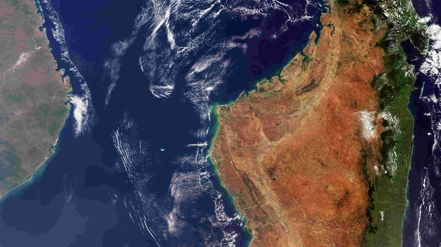
Earth observation image of the week: the Copernicus Sentinel-3 mission takes us over the huge island nation of Madagascar
Earth from Space
9.11.2018 10:05 ESA Observing the Earth
In this week's edition, explore Madagascar with Copernicus Sentinel-3
Start evropské meteorologické družice MetOp-C
9.11.2018 9:40 Český Kosmický PortálTřetí družice řady MetOp označená písmenem „C“ byla vypuštěna na palubě rakety Sojuz z evropského kosmodromu ve Francouzské Guayaně. Její práce zajistí kontinuitu meteorologických dat získávaných z polární oběžné dráhy.
New ESA facility puts satnav at the service of science
9.11.2018 9:03 ESA Navigation
Global satellite navigation systems are continuously bathing Earth in satnav signals. As well as helping in our daily lives, these signals are also tools for cutting-edge science. A new ESA facility, based at ESA’s astronomy centre near Madrid, is championing their use for everything from Earth monitoring to fundamental physics.
GIS and BIM Provide Life Cycle Support for University’s Assets (ArcUser Online)
9.11.2018 9:00 GISCafe.com Webcasts-WebinarsInterview with Pierre d'hauteville, Head of Sales & Marketing, YellowScan at Intergeo 2018
9.11.2018 9:00 GISCafe.com Webcasts-WebinarsINSPIRE téma Rozšířené Parcely (CPX)
9.11.2018 1:00 Cenia - Katalog metadat ČR - INSPIRE Rozšíření má za cíl poskytovat katastrální mapu s obsahem podle vyhlášky ve vektorové podobě ve struktuře plně v souladu se strukturou danou směrnicí INSPIRE. Data rozšiřují směrnici INSPIRE pro téma katastrální parcely (CP) o věcná břemena, geodetické body, další prvky mapy, původní obloukovou geometrii a o parcely určené definičním bodem (ty pouze v oblastech s analogovou mapou). Vychází z katastrální mapy, která je závazným státním mapovým dílem velkého měřítka, obsahuje body polohového bodového pole, polohopis a popis a může mít formu digitální mapy, analogové mapy nebo digitalizované mapy. Publikovaná data obsahují katastrální území pro celou Českou Republiku, parcely a jejich hranice, věcná břemena, další prvky mapy a původní obloukovou geometrii z území, kde je digitální mapa (k 26. 11. 2018 je to 96,16% území České republiky, t.j. 75 840,00km2) a ve zbytku území katastrální parcely určené pouze definičním bodem (tedy bez hranic a polygonu). Katastrální parcely a hranice obsahují oproti datové sadě INSPIRE některé atributy navíc. Jedná se o typ hranice, způsob využití území, druh pozemku, vazbu na budovu a o mapové značky. Více katastrální zákon 344/1992 SB., katastrální vyhláška č.26/2007 Sb. v platném znění a INSPIRE Data Specification on Cadastral Parcels v 3.0.1. Data ve formátu GML 3.2.1 jsou validní proti schématu XML pro Rozšířené Parcely (CPX) ve verzi 4.0.INSPIRE téma Rozšířené Parcely (CPX)
9.11.2018 1:00 Cenia - Katalog metadat ČR - INSPIRE Rozšíření má za cíl poskytovat katastrální mapu s obsahem podle vyhlášky ve vektorové podobě ve struktuře plně v souladu se strukturou danou směrnicí INSPIRE. Data rozšiřují směrnici INSPIRE pro téma katastrální parcely (CP) o věcná břemena, geodetické body, další prvky mapy, původní obloukovou geometrii a o parcely určené definičním bodem (ty pouze v oblastech s analogovou mapou). Vychází z katastrální mapy, která je závazným státním mapovým dílem velkého měřítka, obsahuje body polohového bodového pole, polohopis a popis a může mít formu digitální mapy, analogové mapy nebo digitalizované mapy. Publikovaná data obsahují katastrální území pro celou Českou Republiku, parcely a jejich hranice, věcná břemena, další prvky mapy a původní obloukovou geometrii z území, kde je digitální mapa (k 26. 11. 2018 je to 96,16% území České republiky, t.j. 75 840,00km2) a ve zbytku území katastrální parcely určené pouze definičním bodem (tedy bez hranic a polygonu). Katastrální parcely a hranice obsahují oproti datové sadě INSPIRE některé atributy navíc. Jedná se o typ hranice, způsob využití území, druh pozemku, vazbu na budovu a o mapové značky. Více katastrální zákon 344/1992 SB., katastrální vyhláška č.26/2007 Sb. v platném znění a INSPIRE Data Specification on Cadastral Parcels v 3.0.1. Data ve formátu GML 3.2.1 jsou validní proti schématu XML pro Rozšířené Parcely (CPX) ve verzi 4.0.Významné geologické lokality (optimalizováno pro mobilní zařízení)
9.11.2018 1:00 Cenia - Katalog metadat ČR - INSPIRE ArcGIS Server služba zobrazuje data o významných geologických lokalitách, které nejsou zařazeny do databáze Geologické zajímavosti.Trimble Wraps Up its 9th International User Conference with Record-Breaking Attendance
8.11.2018 23:12 GISCafe.com Webcasts-Webinars Action-Packed Event for Learning, Collaborating and Networking with PeersSUNNYVALE, Calif., Nov. 8, 2018 — (PRNewswire) — Trimble …
Maxar's Radiant Solutions Selected by DARPA to Develop Next-Generation Optical System for Agile Earth Observation Satellites
8.11.2018 23:12 GISCafe.com Webcasts-Webinars HERNDON, VA, Nov. 8, 2018 — (PRNewswire) — Radiant Solutions, a Maxar Technologies company (NYSE: MAXR) (TSX: MAXR), has been …HES Energy Systems Launches 3-hour Endurance Hydrogen Multi-Rotor, Designed & Built in the USA
8.11.2018 23:12 GISCafe.com Webcasts-Webinars AUSTIN, Texas & PARIS & SINGAPORE — (BUSINESS WIRE) — November 8, 2018 —HES
Energy Systems is announcing the …
Kratos Receives $15.2 Million in Unmanned Drone System Contract Awards
8.11.2018 23:12 GISCafe.com Webcasts-Webinars SAN DIEGO, Nov. 08, 2018 (GLOBE NEWSWIRE) -- Kratos Defense & Security Solutions, Inc. (Nasdaq: KTOS), a leading National Security Solutions …FUSE Tether System Completes Law Enforcement Flight Operations at Multiple Large Public Events
8.11.2018 23:12 GISCafe.com Webcasts-Webinars JACKSONVILLE, FL, Nov. 08, 2018 (GLOBE NEWSWIRE) -- Drone Aviation Holding Corp. (OTCQB: DRNE) (“Drone Aviation” or the “Company”), a …City of Cape Coral Relies on Nutanix to Run Life-Saving Applications During Emergencies
8.11.2018 23:12 GISCafe.com Webcasts-Webinars New Solution Increases Application Reliability and Availability toBetter Protect Citizens
SAN JOSE, Calif. — (BUSINESS WIRE) …
Kratos Successfully Completes Multiple Series of High Performance Unmanned Aerial Drone Missions for New and Established National Security Customers
8.11.2018 23:12 GISCafe.com Webcasts-Webinars Recent Exercises Included Multiple Intercepts of Kratos High Performance Target Drone AircraftSAN DIEGO, Nov. 08, 2018 (GLOBE NEWSWIRE) -- …
Carlson Survey OEM 2019 Released
8.11.2018 16:56 Carlson Software MAYSVILLE, Kentucky, U.S.A. (November 2018) — The Carlson Survey 2019 OEM has just been released with the AutoCAD® 2018 OEM engine built-in. Carlson Survey users can read and write directly with the current AutoCAD DWG-drawing file format. Some of the new commands found in Carlson Survey OEM 2019 include: • Elevation Along Entity – A […]Bentley goes open source to enable build-your-own digital twin solutions
8.11.2018 15:41 Bentley SystemsPress Coverage
Spar 3D, USA
Read the articleBentley announcements herald era of the digital twin
8.11.2018 15:34 Bentley SystemsPress Coverage
Power Engineering, USA
Read the articleBentley Systems Releases Open-Source Library: iModel.js
8.11.2018 15:32 Bentley SystemsPress Coverage
ARC Advisory Group, USA
Read the articleAtos and Bentley Systems Announce Strategic Partnership
8.11.2018 15:30 Bentley SystemsPress Coverage
ARC Advisory Group, USA
Read the articleBentley Advances Industrialization of Infrastructure Project Delivery
8.11.2018 15:28 Bentley SystemsPress Coverage
ARC Advisory Group, USA
Read the articleSiemens and Bentley Systems Make Two Announcements
8.11.2018 15:23 Bentley SystemsPress Coverage
ARC Advisory Group, USA
Read the articleHexagon’s Geospatial Division Supporting the SIDE II Contract in the European Union
8.11.2018 12:49 GISCafe.com Webcasts-Webinars Key Luciad Solutions Help Enable EU Agencies to Enhance Geospatial Data Visualization CapabilitiesNORCROSS, Ga., November 6, 2018 – …
GSA Report highlights key user requirements in aviation
8.11.2018 11:54 European GNSS Agency
A Report from the European GNSS Agency (GSA) on Aviation User Needs and Requirements highlights current and future requirements for position, navigation and timing in the aviation sector and will feed into the discussion at the next EGNSS User Consultation Platform (UCP), to be held in Marseille on 3-4 December 2018 as part of European Space Week.
The report, one of a series on User Needs and Requirements for position, navigation and time published recently on the European GNSS Service Centre web portal, provides a reference for the European GNSS Programmes and for the aviation community on the latest GNSS user needs and requirements in the aviation market segment. The report is considered a “living document” and will be periodically updated to reflect the evolution of technology, the market and user needs, as captured during the upcoming UCP.
Watch this: EGNOS for Aviation
With EGNOS fully operational and Galileo providing initial services, it is necessary to continuously improve services and plan future evolutions, and user requirements are a key driver of this process. By providing the GSA with a clear view of current and potential future user needs, the Report will serve as an input for the continuous improvement of services provided by the European GNSS systems. Furthermore, as the report is publicly available, it also serves as a reference for users and industry, supporting their planning and decision-making.
Some key insights
The Report provides an overview of GNSS market trends in the four main aviation applications using GNSS: navigation, surveillance, aircraft tracking and drones. For navigation, the Report notes that, with the increasing implementation of RNP approaches and the expansion of the EGNOS-enabled fleet, there is a need for increased coverage area. The report also notes an increasing trend to combine GNSS with other technologies such as Enhanced Vision Systems and Synthetic Vision Systems.
Regarding Search & Rescue and autonomous aircraft distress tracking, the development of beacons integrating Galileo RLS is progressing, led by major EU manufacturers who are also exploring advanced uses, such as automatic triggering of ELT and remote activation from the ground, opening new opportunities for search and rescue operations.
Finally, for drone operations, Galileo is expected to provide superior performance in challenging environments, facilitating operations in urban canyons, for example. Work is currently ongoing to define a common set of requirements on positioning, navigation and surveillance for drones and follow-up discussions on user needs and requirements for drone operations related to GNSS are fundamental to this process.
The EGNSS User Consultation Platform
The User Consultation Platform (UCP) is a periodic forum organised by the European Commission and the GSA, involving end users, user associations and representatives of the value chain, such as receiver and chipset manufacturers, application developers and the organisations and institutions dealing, directly and indirectly, with Galileo and EGNOS. The event is a part of the process developed at the GSA to collect user needs and requirements and take them as inputs for the provision of user-driven Galileo and EGNOS services.
The next User Consultation Platform will be held on 3-4 December, during European Space Week. The main work of the UCP will be carried out in eight parallel panel sessions grouping users by market segment, with a dedicated session on aviation.
European Space Week also has a special session on the EGNOS Safety of Life Service, which will address EGNOS in action, with presentations of successful EGNOS implementation stories in aviation by a wide range of stakeholders, from airlines to air navigation service providers and from manufacturers to operators. This year, the EGNOS Service Provision Workshop has also been integrated into EUSW.
To join the ongoing discussion and to ensure that future European space programme evolutions meet your needs and requirements, you can take part by registering here.
Media note: This feature can be republished without charge provided the European GNSS Agency (GSA) is acknowledged as the source at the top or the bottom of the story. You must request permission before you use any of the photographs on the site. If you republish, we would be grateful if you could link back to the GSA website (http://www.gsa.europa.eu).
20181108 Vrchní referent/rada oddělení aktualizace popisných informací katastru nemovitostí I.
8.11.2018 10:52 ČÚZK - předpisy a opatření Katastrální úřad pro Středočeský kraj - Katastrální pracoviště Praha-východ zveřejnil novou aktualitu: Vrchní referent/rada oddělení aktualizace popisných informací katastru nemovitostí I. V části "Úřední deska", v sekci "Oznámení a jiná úřední sdělení" bylo vystaveno "Oznámení o vyhlášení výběrového řízení na obsazení služebního místa Vrchní referent/rada oddělení aktualizace popisných informací katastru nemovitostí I."20181108 Vrchní referent/rada oddělení aktualizace popisných informací katastru nemovitostí I.
8.11.2018 10:52 ČÚZK /Urady/Katastralni-urady/Katastralni-urady/Katastralni-urad-pro-Stredocesky-kraj/Katastralni-pracoviste/KP-Praha-vychod/O-uradu/Aktuality/20180601-(2)Vrchní referent/rada oddělení aktualizace popisných informací katastru nemovitostí I.
8.11.2018 10:51 ČÚZK /Urady/Katastralni-urady/Katastralni-urady/Katastralni-urad-pro-Stredocesky-kraj/Uredni-deska/Oznameni-a-jina-uredni-sdeleni/Volna-mista/Vrchni-referent-rada-oddeleni-aktualizace-popisnycVrchní referent/rada oddělení aktualizace popisných informací katastru nemovitostí I.
8.11.2018 10:51 ČÚZK - volná místa Katastrální úřad pro Středočeský kraj - Katastrální pracoviště Praha-východ vypisuje výběrové řízení na místo Vrchní referent/rada oddělení aktualizace popisných informací katastru nemovitostí I.Vrchní referent/rada oddělení aktualizace popisných informací katastru nemovitostí I.
8.11.2018 10:51 ČÚZK - předpisy a opatření Katastrální úřad pro Středočeský kraj - Katastrální pracoviště Praha-východvypisuje výběrové řízení na místo Vrchní referent/rada oddělení aktualizace popisných informací katastru nemovitostí I.
Vrchní referent/rada oddělení aktualizace popisných informací katastru nemovitostí I.
Announcing PointStudio - New name and platform for Maptek spatial data application
8.11.2018 10:29 GISCafe.com Webcasts-Webinars November 08, 2018 -- The launch of PointStudio 8 from Maptek heralds a new name, platform and ribbon interface to the long-standing point cloud …ADC WorldMap Releases Digital Atlas Version 7.5
8.11.2018 9:42 GISCafe.com Webcasts-Webinars New for this release – Flexible Licensing OptionsAppleton, WI-USA – November 6, 2018 – American Digital …
Evropský servisní modul dorazil do Kennedyho kosmického střediska
8.11.2018 9:41 Český Kosmický PortálPo 24 hodin trvající cestě z Brém v Německu se zastávkami v Hamburgu a Portsmouthu (USA) dorazila evropský servisní modul do Kennedyho kosmického střediska na Floridě.
Evropský servisní modul dorazil do Kennedyho kosmického střediska
8.11.2018 9:41 Český Kosmický PortálPo 24 hodin trvající cestě z Brém v Německu se zastávkami v Hamburgu a Portsmouthu (USA) dorazila evropský servisní modul do Kennedyho kosmického střediska na Floridě.
Taking the Next Technological Steps in Eradicating Land Mines (ArcNews Online)
8.11.2018 9:00 GISCafe.com Webcasts-WebinarsInterview with Steve Hamilton, Technical Support Specialist of DAT/EM Systems International at Intergeo 2018
8.11.2018 9:00 GISCafe.com Webcasts-WebinarsINSPIRE téma Rozšířené Parcely (CPX)
8.11.2018 1:00 Cenia - Katalog metadat ČR - INSPIRE Rozšíření má za cíl poskytovat katastrální mapu s obsahem podle vyhlášky ve vektorové podobě ve struktuře plně v souladu se strukturou danou směrnicí INSPIRE. Data rozšiřují směrnici INSPIRE pro téma katastrální parcely (CP) o věcná břemena, geodetické body, další prvky mapy, původní obloukovou geometrii a o parcely určené definičním bodem (ty pouze v oblastech s analogovou mapou). Vychází z katastrální mapy, která je závazným státním mapovým dílem velkého měřítka, obsahuje body polohového bodového pole, polohopis a popis a může mít formu digitální mapy, analogové mapy nebo digitalizované mapy. Publikovaná data obsahují katastrální území pro celou Českou Republiku, parcely a jejich hranice, věcná břemena, další prvky mapy a původní obloukovou geometrii z území, kde je digitální mapa (k 26. 11. 2018 je to 96,16% území České republiky, t.j. 75 840,00km2) a ve zbytku území katastrální parcely určené pouze definičním bodem (tedy bez hranic a polygonu). Katastrální parcely a hranice obsahují oproti datové sadě INSPIRE některé atributy navíc. Jedná se o typ hranice, způsob využití území, druh pozemku, vazbu na budovu a o mapové značky. Více katastrální zákon 344/1992 SB., katastrální vyhláška č.26/2007 Sb. v platném znění a INSPIRE Data Specification on Cadastral Parcels v 3.0.1. Data ve formátu GML 3.2.1 jsou validní proti schématu XML pro Rozšířené Parcely (CPX) ve verzi 4.0.První den Konference GIS Esri v ČR
7.11.2018 20:01 ARCDATAMapy, plány, historie, současnost i budoucnost
Přednášky hlavních řečníků se věnovaly nejen soudobým tématům, jako je pražský Metropolitní plán, ale také historii českého a československého mapování. Připomněly také významná výročí: s naší republikou slaví sto let také vojenská zeměpisná služba a pět staletí uběhlo od vzniku Klaudyánovy mapy.
Co nabízí svět GIS
Odpoledne bylo věnováno technologii. Z Esri přijel Bern Szukalski, který společně se specialisty z ARCDATA PRAHA představil novinky platformy ArcGIS. V technologickém bloku bylo možné vidět i několik hostů z řad uživatelů, kteří ve svých ukázkách demonstrovali, jak jim GIS pomáhá v každodenní práci. Velkým tématem technologického bloku byly také nové možnosti vizualizace dat ve webovém i v desktopovém prostředí.
Na technologický blok tematicky navazovaly dva workshopy – jeden se věnoval mobilním a webovým aplikacím ArcGIS, druhý byl zaměřen na vývoj webových aplikací prostřednictvím ArcGIS API for JavaScript.
Veřejná správa a inženýrské sítě
Večerní přednáškové bloky byly věnovány veřejné správě a inženýrským sítím. Na nich se mohli posluchači dozvědět ještě více podrobností o Metropolitním plánu, Brnem publikovaných datech, integraci BIM a GIS nebo o projektu digitální technické mapy ČR.
V sekci zaměřené na správu inženýrských sítí představili své projekty řečníci ze společností Pražská teplárenská, České Radiokomunikace, SAP, OSIsoft a také z Masarykovy univerzity v Brně.
Výstavy a doprovodný program
V přísálí Společenského sálu jsou k vidění hned dvě rozsáhlé výstavy prezentující Klaudyánovu mapu a historii vojenského mapování. Ve foyer je možné obdivovat dvě velkoformátové mapy – první z nich je věnována tématu komunálních voleb, druhou je vojenská mapa Československa z roku 1920.
Posterová sekce představila na 35 projektů. Během večera mají návštěvníci možnost s autory diskutovat a rozhodnout se, komu věnují svůj hlas při hlasování o Cenu publika.
Ti, kterým nestačila dávka technologie v sálech, mohli další znalosti načerpat z tematických miniseminářů na stánku technické podpory ARCDATA PRAHA. Během společenského večera mohli zájemci na stejném místě okusit virtuální realitu.


Datafesťák 2018
7.11.2018 19:25 GeoBusiness Koncem listopadu se v Hradci Králové uskuteční dvoudenní akce, věnovaná datové analytice pro byznys. Datafesťák má podtitul „Data & business | Data & manufacturing | Data & government ... PřečístBluesky 3D Models Help Anglian Water Improve Infrastructure
7.11.2018 18:22 GISCafe.com Webcasts-Webinars November 07, 2018 -- Highly detailed 3D models, derived from the latest aerial photography, are helping the UK’s Anglian Water design, build …The Dassault Systèmes U.S. Foundation Expands Grant to Base 11 Autonomous Systems Engineering Academy
7.11.2018 18:21 GISCafe.com Webcasts-Webinars Innovative STEM curriculum to be adapted as a full semester courseduring Academic Year 2018/19
COSTA MESA, Calif. & WALTHAM, …