


![]()

zprávy
zdroje zpráv:Drone Service Provider HAZON Solutions Announces Texas Expansion
6.2.2018 0:28 GISCafe.com Webcasts-Webinars VIRGINIA BEACH, Va., Feb. 5, 2018 — (PRNewswire) — HAZON Solutions ("HAZON"), the national leader in drone inspection services, …2018 Advisory board set for commercial uav expo conference program development
5.2.2018 20:33 GISCafe.com Webcasts-WebinarsProagrica Announces Definitive Agreement to Acquire US Farm Solutions Company SST Software
5.2.2018 20:30 GISCafe.com Webcasts-Webinars LONDON, February 5, 2018 — (PRNewswire) — Proagrica, part of RELX Group, a world-leading provider of information and analytics for …International LiDAR Mapping Forum: Ellipse 2 Micro Series Brings Industrial-grade IMU, AHRS, and INS to High Volume Projects
5.2.2018 20:30 GISCafe.com Webcasts-Webinars Carrières-sur-Seine, France, February 2nd 2018 - SBG Systems releases at the International LiDAR Mapping Forum the Ellipse 2 Micro Series, a …SYRIA: Satellite Images of Afrin Identifies Massive Damage to Ancient Temple
5.2.2018 20:15 GISCafe.com Webcasts-Webinars Satellite imagery supplied by European Space Imaging shows that more than half of an ancient temple near the town of Afrin, Syria, has been …DJI to Sponsor AUVSI XPONENTIAL's Inaugural Humanitarian Awards
5.2.2018 17:29 GISCafe.com Webcasts-Webinars Nominations are now open for those using unmanned technology to save lives and improve health and the environmentARLINGTON, Va., Feb. 5, 2018 …
Trimble Announces New MX9 Mobile Mapping System for Surveying, Engineering and Geospatial Professionals
5.2.2018 17:29 GISCafe.com Webcasts-Webinars An Innovative Solution for Large-Scale Scanning and Mapping Missions Delivers Data Confidence, Precision and High EfficiencySUNNYVALE, Calif., Feb. …
HP Accelerates Democratization of 3D Printing With Breakthrough Full Color Platform
5.2.2018 17:28 GISCafe.com Webcasts-Webinars News highlights: Introducing the industry’s only …
HP Revs Up Workstation, Unveils New VR Products and Services
5.2.2018 17:28 GISCafe.com Webcasts-Webinars HP’s comprehensive end-to-end solution for product development workflows showcased at SOLIDWORKS World News …Teledyne Optech announces the new ALTM™ Galaxy PRIME
5.2.2018 17:27 GISCafe.com Webcasts-Webinars February 5, 2018 — Teledyne Optech is pleased to announce the latest addition to its innovative line of airborne laser terrain mappers, the …Bentley Pours Foundation for India Expansion with Acquisition of Concrete Specialist
5.2.2018 17:25 Bentley SystemsPress Coverage
Engineering.com, USA
Read the articleNew Offering Will Help Utilities Better Manage DERs on Their Power Systems
5.2.2018 17:21 Bentley SystemsPress Coverage
Renewable Energy World, USA
Read the articleBentley Hexagon active in acquisitions
5.2.2018 16:00 Bentley SystemsPress Coverage
Schnitger Group, USA
Read the articleSoftware speeds water plant project
5.2.2018 15:53 Bentley SystemsPress Coverage
Control, USA
Read the articleRozhovor s Tomášem Renčínem o připravované konferenci ISSS 2018
5.2.2018 15:46 GeoBusiness Zeptali jsme se programového ředitele konference ISSS, co letos chystají do programu 21. ročníku. Konferenci ISSS pořádáte již hodně dlouhou dobu. Měl jste možnost ... PřečístChange in atmosphere
5.2.2018 15:06 ESA Observing the Earth
Discover how ESA’s Climate Change Initiative uses satellite data going back 30 years to understand how our atmosphere is changing
Přerušení provozu DP a WSDP v pátek 9.2.2018 od 15:30 až do cca 17:30.
5.2.2018 13:57 Dálkový přístup k údajům KN ČR Vážení uživatelé,oznamujeme, že v pátek 9.2.2018 od 15:30 bude z provozních důvodů zcela přerušen provoz Dálkového přístupu i Webových služeb dálkového přístupu. Obnovení provozu předpokládáme v cca 17:30 hodin.
Za komplikace tímto způsobené se omlouváme a děkujeme za pochopení.
Přerušení provozu DP a WSDP v pátek 9.2.2018 od 15:30 až do cca 17:30.
5.2.2018 13:57 ČÚZK /Aplikace-DP-do-KN/Aplikace-DP-do-KN/Archiv-DP/209239Přerušení provozu DP a WSDP v pátek 9.2.2018 od 15:30 až do cca 17:30.
5.2.2018 13:57 ČÚZK - předpisy a opatření Vážení uživatelé,oznamujeme, že v pátek 9.2.2018 od 15:30 bude z provozních důvodů zcela přerušen provoz Dálkového přístupu i Webových služeb dálkového přístupu. Obnovení provozu předpokládáme v cca 17:30 hodin.
Za komplikace tímto způsobené se omlouváme a děkujeme za pochopení.
Pozvánka na valnou hromadu
5.2.2018 12:45 Asociace podnikatelů v geomatice 1. valná hromada APG se uskuteční 12. února 2018Are you a Galileo fan? See what’s awaiting you at this year’s MWC!
5.2.2018 12:01 European GNSS Agency
The European GNSS Agency (GSA) will be showcasing Galileo-based innovations during the GSMA Mobile World Congress (MWC).
As the premiere mobile show, the Mobile World Congress (MWC) attracts hundreds of thousands of companies, entrepreneurs and users from around the world. It serves as the global stage for debuting and promoting exiting new innovations – from drones to smart cars, smartphones and even Artificial Intelligence.
MWC 2018, which takes place on 26 February to 1 March in Barcelona, marks the first time that the GSA will be exhibiting at the show. From Stand 8.0G17 in Hall 8, the Agency will be putting Galileo on full display. “With Galileo Initial Services launching in late 2016, this is the first show where we have Galileo products on display at MWC” says Justyna Redelkiewicz, in charge of LBS Market Development at the GSA. “With 75 million Galileo-enabled smartphones sold last year – and more models coming to market all the time – it’s really an exciting time for Galileo.”
The GSA encourages everyone to share in the excitement by visiting their booth and learning more about how Galileo enhances smartphones and other mobile devices. “We will have a range of Galileo-enabled smartphones on display, along with GNSS experts ready to show you how Galileo can improve your phone’s performance,” adds Redelkiewicz. “And if you come with a smartphone that is already using Galileo, we’ll give you a free ‘I #UseGalileo’ t-shirt to commemorate your MWC experience.”
Drones on display
In addition to smartphones, the GSA booth will also serve as a showcase on how Galileo-enabled drones benefit a range of different applications, including surveying, search and rescue and agriculture. The stand will feature displays and presentations on a number of EU-funded drone projects, including selected GSA-managed H2020 projects including 5-lives, EASY-PV, Gauss, Geovision and Mapkite, and the Argonaut solution developed within the Barcelona ESA Business Incubation Centre.
For instance, the EASY PV project uses remotely piloted aircraft systems (RPAS) to provide a more effective and cost-efficient solution for inspecting photovoltaic (PV) plants. The automated system acquires, geo-references and processes both visual and thermal images using an RPAS equipped with a high-accuracy Galileo receiver.
MapKITE, a mapping-based project exhibiting at the GSA booth, integrates Galileo-capable drones with terrestrial mobile mapping systems to provide surveyors and mappers with an end-to-end solution for 3D high-resolution corridor mapping. “While terrestrial mobile mapping systems are becoming a standard surveying tool, their use is restricted due to their limited and insufficient view from the ground,” says Project Coordinator Pere Molina. “As mapping of small areas via drones is now a reality, this project combines the best of both worlds by incorporating aerial and terrestrial components.”
According to the GSA, many drone manufacturers see GNSS as the answer to the growing need for highly accurate and reliable performance to ensure safe drone navigation, especially in light of the booming market for professional applications that also involve operations beyond line of sight. Luckily, GNSS offers a solution. “In order to navigate efficiently and safely, drones are becoming increasingly dependent on satellite navigation signals, including Galileo, for their robust positioning and orientation information. Multi-constellation receivers using Galileo increase availability and accuracy, an enabler for demanding operations such as those in urban areas,” says Carmen Aguilera in charge of Aviation Market Development at the GSA. “It is because of this robust navigation that drones and all of the innovations seen at MWC depend on GNSS becoming the essential infrastructure for the technology of tomorrow.”
To learn more about these or any of the other projects that will be on display, please contact market@gsa.europa.eu in advance to schedule an appointment.
MWC 2018 takes place 26 February to 1 March at Barcelona’s Fira Gran Via. The GSA is located in Hall 8, Stand 8.0G17.
Media note: This feature can be republished without charge provided the European GNSS Agency (GSA) is acknowledged as the source at the top or the bottom of the story. You must request permission before you use any of the photographs on the site. If you republish, we would be grateful if you could link back to the GSA website (http://www.gsa.europa.eu).
Are you a Galileo fan? See what’s awaiting you at this year’s MWC!
5.2.2018 12:01 European GNSS Agency
The European GNSS Agency (GSA) will be showcasing Galileo-based innovations during the GSMA Mobile World Congress (MWC).
As the premiere mobile show, the Mobile World Congress (MWC) attracts hundreds of thousands of companies, entrepreneurs and users from around the world. It serves as the global stage for debuting and promoting exiting new innovations – from drones to smart cars, smartphones and even Artificial Intelligence.
MWC 2018, which takes place on 26 February to 1 March in Barcelona, marks the first time that the GSA will be exhibiting at the show. From Stand 8.0G17 in Hall 8, the Agency will be putting Galileo on full display. “With Galileo Initial Services launching in late 2016, this is the first show where we have Galileo products on display at MWC” says Justyna Redelkiewicz, in charge of LBS Market Development at the GSA. “With 75 million Galileo-enabled smartphones sold last year – and more models coming to market all the time – it’s really an exciting time for Galileo.”
The GSA encourages everyone to share in the excitement by visiting their booth and learning more about how Galileo enhances smartphones and other mobile devices. “We will have a range of Galileo-enabled smartphones on display, along with GNSS experts ready to show you how Galileo can improve your phone’s performance,” adds Redelkiewicz. “And if you come with a smartphone that is already using Galileo, we’ll give you a free ‘I #UseGalileo’ t-shirt to commemorate your MWC experience.”
Drones on display
In addition to smartphones, the GSA booth will also serve as a showcase on how Galileo-enabled drones benefit a range of different applications, including surveying, search and rescue and agriculture. The stand will feature displays and presentations on a number of EU-funded drone projects, including selected GSA-managed H2020 projects including Real, EASY-PV, Gauss, Geovision and Mapkite, and the Argonaut solution developed within the Barcelona ESA Business Incubation Centre.
For instance, the EASY PV project uses remotely piloted aircraft systems (RPAS) to provide a more effective and cost-efficient solution for inspecting photovoltaic (PV) plants. The automated system acquires, geo-references and processes both visual and thermal images using an RPAS equipped with a high-accuracy Galileo receiver.
MapKITE, a mapping-based project exhibiting at the GSA booth, integrates Galileo-capable drones with terrestrial mobile mapping systems to provide surveyors and mappers with an end-to-end solution for 3D high-resolution corridor mapping. “While terrestrial mobile mapping systems are becoming a standard surveying tool, their use is restricted due to their limited and insufficient view from the ground,” says Project Coordinator Pere Molina. “As mapping of small areas via drones is now a reality, this project combines the best of both worlds by incorporating aerial and terrestrial components.”
According to the GSA, many drone manufacturers see GNSS as the answer to the growing need for highly accurate and reliable performance to ensure safe drone navigation, especially in light of the booming market for professional applications that also involve operations beyond line of sight. Luckily, GNSS offers a solution. “In order to navigate efficiently and safely, drones are becoming increasingly dependent on satellite navigation signals, including Galileo, for their robust positioning and orientation information. Multi-constellation receivers using Galileo increase availability and accuracy, an enabler for demanding operations such as those in urban areas,” says Carmen Aguilera in charge of Aviation Market Development at the GSA. “It is because of this robust navigation that drones and all of the innovations seen at MWC depend on GNSS becoming the essential infrastructure for the technology of tomorrow.”
To learn more about the integration of EGNOS and Galileo in drones and UAVs, we have scheduled a series of short presentations and Q&A sessions, click here to find the programme and the contact details.
MWC 2018 takes place 26 February to 1 March at Barcelona’s Fira Gran Via. The GSA is located in Hall 8, Stand 8.0G17.
Media note: This feature can be republished without charge provided the European GNSS Agency (GSA) is acknowledged as the source at the top or the bottom of the story. You must request permission before you use any of the photographs on the site. If you republish, we would be grateful if you could link back to the GSA website (http://www.gsa.europa.eu).
Are you a Galileo fan? See what’s awaiting you at this year’s MWC!
5.2.2018 12:01 European GNSS AgencyThe European GNSS Agency (GSA) will be showcasing Galileo-based innovations during the GSMA Mobile World Congress (MWC).
As the premiere mobile show, the Mobile World Congress (MWC) attracts hundreds of thousands of companies, entrepreneurs and users from around the world. It serves as the global stage for debuting and promoting exiting new innovations – from drones to smart cars, smartphones and even Artificial Intelligence.
MWC 2018, which takes place on 26 February to 1 March in Barcelona, marks the first time that the GSA will be exhibiting at the show. From Stand 8.0G17 in Hall 8, the Agency will be putting Galileo on full display. “With Galileo Initial Services launching in late 2016, this is the first show where we have Galileo products on display at MWC” says Justyna Redelkiewicz, in charge of LBS Market Development at the GSA. “With 75 million Galileo-enabled smartphones sold last year – and more models coming to market all the time – it’s really an exciting time for Galileo.”
The GSA encourages everyone to share in the excitement by visiting their booth and learning more about how Galileo enhances smartphones and other mobile devices. “We will have a range of Galileo-enabled smartphones on display, along with GNSS experts ready to show you how Galileo can improve your phone’s performance,” adds Redelkiewicz. “And if you come with a smartphone that is already using Galileo, we’ll give you a free ‘I #UseGalileo’ t-shirt to commemorate your MWC experience.”
Drones on display
In addition to smartphones, the GSA booth will also serve as a showcase on how Galileo-enabled drones benefit a range of different applications, including surveying, search and rescue and agriculture. The stand will feature displays and presentations on a number of EU-funded drone projects, including selected GSA-managed H2020 projects including Real, EASY-PV, Gauss, Geovision and Mapkite, and the Argonaut solution developed within the Barcelona ESA Business Incubation Centre.
For instance, the EASY PV project uses remotely piloted aircraft systems (RPAS) to provide a more effective and cost-efficient solution for inspecting photovoltaic (PV) plants. The automated system acquires, geo-references and processes both visual and thermal images using an RPAS equipped with a high-accuracy Galileo receiver.
MapKITE, a mapping-based project exhibiting at the GSA booth, integrates Galileo-capable drones with terrestrial mobile mapping systems to provide surveyors and mappers with an end-to-end solution for 3D high-resolution corridor mapping. “While terrestrial mobile mapping systems are becoming a standard surveying tool, their use is restricted due to their limited and insufficient view from the ground,” says Project Coordinator Pere Molina. “As mapping of small areas via drones is now a reality, this project combines the best of both worlds by incorporating aerial and terrestrial components.”
According to the GSA, many drone manufacturers see GNSS as the answer to the growing need for highly accurate and reliable performance to ensure safe drone navigation, especially in light of the booming market for professional applications that also involve operations beyond line of sight. Luckily, GNSS offers a solution. “In order to navigate efficiently and safely, drones are becoming increasingly dependent on satellite navigation signals, including Galileo, for their robust positioning and orientation information. Multi-constellation receivers using Galileo increase availability and accuracy, an enabler for demanding operations such as those in urban areas,” says Carmen Aguilera in charge of Aviation Market Development at the GSA. “It is because of this robust navigation that drones and all of the innovations seen at MWC depend on GNSS becoming the essential infrastructure for the technology of tomorrow.”
To learn more about these or any of the other projects that will be on display, please contact market@gsa.europa.eu in advance to schedule an appointment.
MWC 2018 takes place 26 February to 1 March at Barcelona’s Fira Gran Via. The GSA is located in Hall 8, Stand 8.0G17.
Media note: This feature can be republished without charge provided the European GNSS Agency (GSA) is acknowledged as the source at the top or the bottom of the story. You must request permission before you use any of the photographs on the site. If you republish, we would be grateful if you could link back to the GSA website (http://www.gsa.europa.eu).
První družice ESA v roce 2018 má velikost krabice od snídaňových lupínků
5.2.2018 10:08 Český Kosmický PortálV pátek 2. února byla vypuštěna první letošní mise ESA: družice GomX-4B, která je dosud nejpokročilejším testovacím zařízením agentury. Obsahuje hyperspektrální kameru nebo drobné trysky pro manévrování tisíce kilometrů od svého téměř identického dvojčete, což umožní vyzkoušet rádiové spojení na tyto vzdálenosti.
Bitcoin, aneb kde jím mohu zaplatit v ČR?
5.2.2018 8:25 GISportal.cz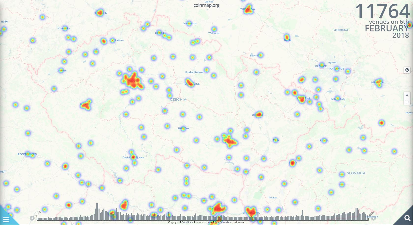
Bitcoin, aneb kde jím mohu zaplatit v ČR?
5.2.2018 8:25 GISportal.czBitcoin, open-source P2P platební síť a také v této síti používaná kryptoměna, zažívá velmi turbulentní období. Kdo koupil před Vánocemi si nyní asi trhá vlasy, na druhou stranu, ten kdo nkoupil před rokem a prodal na Vánoce, se asi nyní směje. Pokud vlastníte nějaké Bitcoiny, tak možná využijete Coinmap, která zobrazuje místa, kde můžete Bitcoiny […]
The post Bitcoin, aneb kde jím mohu zaplatit v ČR? appeared first on GISportal.cz.
Bitcoin, aneb kde jím mohu zaplatit v ČR?
5.2.2018 8:25 GISportal.cz Bitcoin, open-source P2P platební síť a také v této síti používaná kryptoměna, zažívá velmi turbulentní období. Kdo koupil před Vánocemi si nyní asi trhá vlasy, na druhou stranu, ten kdo nkoupil před rokem a prodal ...Bitcoin, aneb kde jím mohu zaplatit v ČR?
5.2.2018 8:25 GISportal.czBitcoin, open-source P2P platební síť a také v této síti používaná kryptoměna, zažívá velmi turbulentní období. Kdo koupil před Vánocemi si nyní asi trhá vlasy, na druhou stranu, ten kdo nkoupil před rokem a prodal na Vánoce, se asi nyní směje. Pokud vlastníte nějaké Bitcoiny, tak možná využijete Coinmap, která zobrazuje místa, kde můžete Bitcoiny […]
The post Bitcoin, aneb kde jím mohu zaplatit v ČR? appeared first on GISportal.cz.
Prezentace z workshopu Velká a otevřená data...
5.2.2018 7:00 Česká asociace pro geoinformace V pondělí 22. ledna proběhl na Novotného lávce v Praze workshop Velká a otevřená data a otevřený software pro praxi. Organizátoři konference (CAGI, katedra Geomatiky ZČU, HSRS, České centrum pro vědu a společnost, Wirelessinfo a Plan4all z.s.) nyní zveřejnili prezentace k jednotlivým příspěvkům naAMBIS Vysoká škola - Dny otevřených dveří
5.2.2018 7:00 Česká asociace pro geoinformace Kolektivní člen CAGI, Vysoká škola regionální rozvoje a Bankovní institut AMBIS, pořádá v únoru a v březnu dny otevřených dveří, a to v těchto termínech a na těchto místech:6. 2. Nárožní 2600/9, Praha
20. 2. Nárožní 2600/9, Praha; Hudcova 367/78, Brno
20. 3. Nárožní 2600/9, Praha; Hudcova 367/78, Brno
6. 2. Nárožní 2600/9, Praha
20. 2. Nárožní
Mapy ČÚZK (Android)
5.2.2018 1:00 Cenia - Katalog metadat ČR - INSPIRE Aplikace Mapy ČÚZK pro mobilní zařízení s operačním systémem Android nabízí prohlížení mapových produktů z tvorby resortu Českého úřadu zeměměřického a katastrálního. Mapy jsou poskytovány výhradně vlastními prohlížecími službami WMS a WMTS. Kromě aktuálních dat jsou zobrazovány i archivní mapy z Ústředního archivu zeměměřictví a katastru.Kromě prohlížení map aplikace dále umožňuje:dotazování na informace z katastru nemovitostí, dotazování na přesně určené souřadnice a další údaje o bodech z databáze bodových polí ČR, vyhledávání místa v mapě podle pravidelně ověřovaných registrů a databází geografických jmen, správního členění a adres. Aplikace již není aktualizována, neboť byla nahrazena na mobilní platformě nezávislou webovou aplikací, odlehčenou verzí aplikace Geoprohlížeč, která je dostupná na adrese http://geoportal.cuzk.cz/mapycuzk.Mapy ČÚZK (iOS)
5.2.2018 1:00 Cenia - Katalog metadat ČR - INSPIRE Aplikace Mapy ČÚZK pro mobilní zařízení s operačním systémem iOS (Apple) nabízí prohlížení mapových produktů z tvorby resortu Českého úřadu zeměměřického a katastrálního. Mapy jsou poskytovány výhradně vlastními prohlížecími službami WMS a WMTS. Kromě aktuálních dat jsou zobrazovány i archivní mapy z Ústředního archivu zeměměřictví a katastru.Kromě prohlížení map aplikace dále umožňuje:dotazování na informace z katastru nemovitostí, dotazování na přesně určené souřadnice a další údaje o bodech z databáze bodových polí ČR, vyhledávání místa v mapě podle pravidelně ověřovaných registrů a databází geografických jmen, správního členění a adres. Aplikace již není aktualizována, neboť byla nahrazena na mobilní platformě nezávislou webovou aplikací, odlehčenou verzí aplikace Geoprohlížeč, která je dostupná na adrese http://geoportal.cuzk.cz/mapycuzk.ÚSES - koncepční vymezení nadregionálních biocenter
5.2.2018 1:00 Cenia - Katalog metadat ČR - INSPIRE Hranice aktualizovaných nadregionálních biocenter vymezených nad katastrálními příp. lesnickými obrysovými mapami; vrstva obsahuje jednoduché prvky (Singlepart Features); © AOPK ČR, 2018Inženýrskogeologické rajony 1 : 500 000
5.2.2018 1:00 Cenia - Katalog metadat ČR - INSPIRE ArcGIS Server služba zobrazující inženýrskogeologické rajony v České republice v měřítku 1 : 500 000.Kvartérní pokryv 1 : 500 000
5.2.2018 1:00 Cenia - Katalog metadat ČR - INSPIRE ArcGIS Server služba zobrazuje nejdůležitější typy kvartérních sedimentů, tj. eolické, říční, ledovcové a organické. Z říčních sedimentů jsou zvlášť vyčleněny současné nivy, ohrožené možnými záplavami za povodní. Ledovcové uloženiny se vyskytují v okrajové oblasti severních Čech a severní Moravy. Z organických sedimentů jsou rašeliny vázány na horské oblasti, slatiny na nižší nadmořské výšky. Travertiny členíme na karbonáty termálních mineralizovaných vod a karbonáty vysrážené ze studených vod prostých.Mapy ČÚZK (Windows Phone 8.1)
5.2.2018 1:00 Cenia - Katalog metadat ČR - INSPIRE Aplikace Mapy ČÚZK pro mobilní telefony s operačním systémem Windows Phone 8.1 nabízí prohlížení mapových produktů z tvorby resortu Českého úřadu zeměměřického a katastrálního. Mapy jsou poskytovány výhradně vlastními prohlížecími službami WMS a WMTS. Kromě aktuálních dat jsou zobrazovány i archivní mapy z Ústředního archivu zeměměřictví a katastru.Kromě prohlížení map aplikace dále umožňuje:dotazování na informace z katastru nemovitostí, dotazování na přesně určené souřadnice a další údaje o bodech z databáze bodových polí ČR, vyhledávání místa v mapě podle pravidelně ověřovaných registrů a databází geografických jmen, správního členění a adres. Aplikace již není aktualizována, neboť byla nahrazena na mobilní platformě nezávislou webovou aplikací, odlehčenou verzí aplikace Geoprohlížeč, která je dostupná na adrese http://geoportal.cuzk.cz/mapycuzk.Mapy ČÚZK (Windows 8.1)
5.2.2018 1:00 Cenia - Katalog metadat ČR - INSPIRE Aplikace Mapy ČÚZK pro mobilní zařízení typu notebook, tablet apod. s operačním systémem Windows 8.1 nabízí prohlížení mapových produktů z tvorby resortu Českého úřadu zeměměřického a katastrálního. Mapy jsou poskytovány výhradně vlastními prohlížecími službami WMS a WMTS. Kromě aktuálních dat jsou zobrazovány i archivní mapy z Ústředního archivu zeměměřictví a katastru.Kromě prohlížení map aplikace dále umožňuje:dotazování na informace z katastru nemovitostí, dotazování na přesně určené souřadnice a další údaje o bodech z databáze bodových polí ČR, vyhledávání místa v mapě podle pravidelně ověřovaných registrů a databází geografických jmen, správního členění a adres. Aplikace již není aktualizována, neboť byla nahrazena na mobilní platformě nezávislou webovou aplikací, odlehčenou verzí aplikace Geoprohlížeč, která je dostupná na adrese http://geoportal.cuzk.cz/mapycuzk.Probíhá nábor nových členů a příprava na valnou hromadu APG.
4.2.2018 12:45 Asociace podnikatelů v geomatice Přihláška pro zájemce o členství v APG a pokyny k uhrazení členského poplatku"Geospatial Corporation Integrates Blockchain Technology with GeoUnderground" by Susan Smith
4.2.2018 12:16 GISCafe.com Webcasts-WebinarsOrbit GT releases major update of 3D Mapping Cloud
4.2.2018 12:13 GISCafe.com Webcasts-Webinars Orbit GT releases a major update of it’s game-changing SaaS product 3D Mapping Cloud.Lokeren, Belgium, February 2nd, 2018 - “3D …
Stanovy APG schválené na valné hromadě 8.1.2018
3.2.2018 12:45 Asociace podnikatelů v geomatice Na valné hromadě byly schváleny stanovy APG.Windy hledá programátora
3.2.2018 7:00 Česká asociace pro geoinformace Seznam hledá programátora v C++ nebo JavaScriptu pro aplikaci na předpověď počasí Windy.com (vítěze Křišťálové lupy pro nejlepší globální projekt českýchZemřel Ing. Oldřich Pašek
2.2.2018 23:11 Zeměměřič Zemřel 25. ledna ve věku 63 let. Poslední rozloučení proběhlo 31. ledna v Opavě.Bentley Systems acquires VC-backed software products firm S-Cube Futuretech
2.2.2018 21:31 Bentley SystemsPress Coverage
VCCircle, USA
Read the articleA Legacy of Best Practice in BIM: Lessons from the BIM Advancement Academy
2.2.2018 21:28 Bentley SystemsPress Coverage
AECbytes, USA
Read the articleMicroStation CONNECT Edition -- It's Not Only About the UX
2.2.2018 21:22 Bentley SystemsPress Coverage
MicroStation Connections, USA
Read the articleVčera byla předpremiéra dokumentu Morava 360 pro který jsme natáčeli letecké záběry
2.2.2018 20:39 UpVision Včera byla v Hvězdárně a planetáriu Brno předpremiéra unikátního fulldome dokumentu Morava 360, pro který jsme déle než rok natáčeli letecké záběry na Jižní Moravě.Dokument je promítán na kulový strop planetária a přináší tak nový úhel pohledu na Moravu v leže. :-)
Více o dokumentu zde včetně ukázky:
http://www.hvezdarna.cz/?p=7008
2.2 2018 - rada/odborný rada - právník
2.2.2018 18:07 ČÚZK - předpisy a opatření Katastrální úřad pro hlavní město Prahu - Katastrální pracoviště Praha zveřejnil novou aktualitu: Nově vyhlášené výběrové řízení na služební místo:vrchní referent/odborný referent – mzdový/á účetní
2.2 2018 - rada/odborný rada - právník
2.2.2018 18:07 ČÚZK /Urady/Katastralni-urady/Katastralni-urady/Katastralni-urad-pro-hlavni-mesto-Prahu/O-uradu/Aktuality/2-2-2018-rada-odborny-rada-pravnikReferent KN – poskytování informací KN
2.2.2018 18:07 ČÚZK - předpisy a opatření Katastrální úřad pro hlavní město Prahu zveřejnil novou aktualitu: Nově vyhlášené výběrové řízení na služební místo:Referent KN – poskytování informací KN, nahlížení do KN
Referent KN – poskytování informací KN
2.2.2018 18:07 ČÚZK /Urady/Katastralni-urady/Katastralni-urady/Katastralni-urad-pro-hlavni-mesto-Prahu/O-uradu/Aktuality/2-2-2018-rada-odborny-rada-pravnikOdborný referent – zápis do protokolu řízení V a Z
2.2.2018 18:05 ČÚZK - volná místa Katastrální úřad pro hlavní město Prahu - Katastrální pracoviště Praha vypisuje výběrové řízení na místo Odborný referent – zápis do protokolu řízení V a ZOdborný referent – zápis do protokolu řízení V a Z
2.2.2018 18:05 ČÚZK - předpisy a opatření Katastrální úřad pro hlavní město Prahu - Katastrální pracoviště Prahavypisuje výběrové řízení na místo
Odborný referent – zápis do protokolu řízení V a Z
Odborný rada - právník
2.2.2018 18:05 ČÚZK - volná místa Katastrální úřad pro hlavní město Prahu - Katastrální pracoviště Praha vypisuje výběrové řízení na místo Odborný rada - právníkvrchní referent/odborný referent – mzdový/á účetní
2.2.2018 18:05 ČÚZK - předpisy a opatření Katastrální úřad pro hlavní město Prahu - Katastrální pracoviště Prahavypisuje výběrové řízení na místo
vrchní referent/odborný referent – mzdový/á účetní
Odborný rada - právník
2.2.2018 18:05 ČÚZK /Urady/Katastralni-urady/Katastralni-urady/Katastralni-urad-pro-hlavni-mesto-Prahu/Uredni-deska/Oznameni-a-jina-uredni-sdeleni/Volna-mista/2-2-2018-rada-odborny-rada-pravnikvrchní referent/odborný referent – mzdový/á účetní
2.2.2018 18:05 ČÚZK /Urady/Katastralni-urady/Katastralni-urady/Katastralni-urad-pro-hlavni-mesto-Prahu/Uredni-deska/Oznameni-a-jina-uredni-sdeleni/Volna-mista/2-2-2018-rada-odborny-rada-pravnikOdborný rada - právník
2.2.2018 18:05 ČÚZK - předpisy a opatření Katastrální úřad pro hlavní město Prahu - Katastrální pracoviště Prahavypisuje výběrové řízení na místo
Odborný rada - právník
Odborný referent – zápis do protokolu řízení V a Z
2.2.2018 18:05 ČÚZK /Urady/Katastralni-urady/Katastralni-urady/Katastralni-urad-pro-hlavni-mesto-Prahu/Uredni-deska/Oznameni-a-jina-uredni-sdeleni/Volna-mista/2-2-2018-rada-odborny-rada-pravnikvrchní referent/odborný referent – mzdový/á účetní
2.2.2018 18:05 ČÚZK - volná místa Katastrální úřad pro hlavní město Prahu - Katastrální pracoviště Praha vypisuje výběrové řízení na místo vrchní referent/odborný referent – mzdový/á účetníETH Zurich – Software Engineer 80 – 100%
2.2.2018 17:01 Das Institut für Kartografie und Geoinformation der ETH Zürich entwickelt im Auftrag des Bundes den nationalen ATLAS DER SCHWEIZ (www.atlasderschweiz.ch). Der interaktive ATLAS DER SCHWEIZ hat sich weltweit als Spitzenprodukt der Kartografie etabliert. Die aktuelle Version wurde in einem mehrjährigen Projekt als online 3D-Atlas mit OpenSource-Frameworks neu entwickelt. Für die Weiterentwicklung des Atlasprojekts suchen wir […]Software Developer Geoinformation Technology
2.2.2018 16:55 Heidelberg Institute for Geoinformation Technology (HeiGIT) and GIScience Research Group In the context of research projects at HeiGIT and the GIScience Research Group we offer the position of a Software Developer Geoinformation Technology in Heidelberg (full-time or part-time). Depending on your experience the tasks are related to at least one of the following areas: Development and […]Department Head, Geomatics Engineering, University of Calgary
2.2.2018 16:53 The University of Calgary’s Schulich School of Engineering invites applications for an appointment with tenure at the rank of Professor to serve as the Department Head,Geomatics Engineering. This is a key leadership position within the Schulich School of Engineering (SSE). The Department Head appointment is a five-year term, renewable and subject to review. The Schulich School of Engineering (SSE) is a leader […]Spatial Data Architect
2.2.2018 16:51 http://bit.ly/SmithSDAposition Contribute to a growing team of partners including faculty, librarians, and educational technologists focused on building capacity in spatial analysis and spatial data visualization within the library and across campus. Advance knowledge and skills in spatial science within the Library’s Teaching, Learning, and Research (TLR) team to support spatial thinking and spatial literacy across […]Bentley Systems Acquires S-Cube Futuretech
2.2.2018 16:31 Bentley SystemsPress Coverage
citybizlist, USA
Read the articleDJI to Sponsor AUVSI XPONENTIAL's Inaugural Humanitarian Awards
2.2.2018 16:22 GISCafe.com Webcasts-Webinars Nominations are now open for those using unmanned technology to save lives and improve health and the environmentARLINGTON, Va., Feb. 2, 2018 …
Sentinel-3B good to go
2.2.2018 15:52 ESA Observing the Earth
After being put through its paces to make sure it is fit for life in orbit around Earth, the Copernicus Sentinel-3B satellite is ready to be packed up and shipped to Russia for liftoff.
Laser Scans Reveal Maya "Megalopolis" Below Guatemalan Jungle (National Geographic)
2.2.2018 15:11 GISCafe.com Webcasts-Webinars February 2, 2018 -- In what’s being hailed as a “major breakthrough” in Maya archaeology, researchers have identified the ruins of …GEO-VISION solutions help emergency responders to save lives
2.2.2018 14:05 European GNSS Agency
The RAIDO and AGILE solutions developed by partners in the project GEO-VISION (GNSS-driven EO and Verifiable Image and Sensor Integration for mission-critical Operational Networks) increase the situational awareness of emergency services and allow first responders to check the integrity of the GNSS signals they receive, increasing the efficiency of the emergency response and helping to save more lives.
For emergency services operating in disaster zones, the ability to obtain and process critical information regarding the physical environment in which they are operating, and to quickly verify the integrity of positioning information that they receive, is of vital importance – allowing them to streamline their efforts and target their response. The RAIDO and AGILE solutions developed within the GEO-VISION project address these very requirements and have commercial applications that extend beyond the project.
Supporting mission-critical communications
The first commercial offer to be generated by the project is the RAIDO solution developed by Norwegian software developer AnsuR. RAIDO is a software system for mission-critical multimedia communications. The system consists of three separate products that work both individually and together. The ASIGN component is used to communicate visual content (photos and videos), which is then streamed over unknown, changing, and bandwidth-limited networks using the ASMIRA tool. Finally, the project’s AIR component is used to route ASIGN and ASMIRA data over various networks.
The optimised communication of visual content, adaptive streaming, smart network management, geo-tagging and mapping offered by RAIDO improves decision-makers’ situational awareness, allowing them to act faster and make better decisions. RAIDO products can be used for a range of stand-alone and integrated solutions. Within the GEO-VISION project, RAIDO will improve the efficiency of crisis and disaster management, but the solution can also be put to good use in other applications, such as photo and video surveillance and security, where better situational awareness can improve operations and cut costs.
“The opportunity of having a H2020 project with the GSA was instrumental for developing mission-critical solutions to provide visual geo-intelligence from ground and aerial cameras for users in crisis and emergency situations and in security operations. We consider the impact of the project to be very high, with global interest, several offers, first sales and the deployment already of unique technologies,” Project Coordinator Harald Skinnemoen said. “We are grateful for the active support of the GSA and their experts, which helped keep focus and momentum up, and we look forward to working with the GSA again in the future."
Checking GNSS integrity
Also developed within the GEO-VISION project, the AGILE solution developed by Italy’s Rina Consulting S.p.A. (formerly D’Appolonia) is a software tool that combines receiver post-correlation anti-jamming techniques with consistency cross-checks with the inertial measurement unit (IMU) on UAVs, to combat spoofing. The AGILE tool is designed as multi-thread application in which signal integrity is checked in two sub-threads.
The first of these - GNSS Spoofing Attack Detection (SAD) – stores the positioning information from the GNSS receiver and the IMU to allow a constant cross-check between the two tracks. The second thread - GNSS Jamming Attack Detection (JAD) - constantly monitors the GNSS receiver signal acquisition log to detect anomalies. Anomalies are flagged whenever parameter values exceed a set threshold for a pre-defined amount of time.
In addition to checking the GNSS signal integrity, the tool also sends notifications to personnel in the Operation Centre about the UAV location as well as a system status message to the pilot. Like the RAIDO solution, the AGILE tool can also be replicated in other applications sensitive to precise location information, such as the transportation of dangerous goods, for example.
Solutions being rolled out
The GEO-VISION project built on existing initiatives, proven concepts, and user requirements to offer a solution that can be used to manage the operational phases of disasters and emergencies, as well as conduct rapid damage assessments as a basis for insurance and cost estimates. Following the project’s completion in December 2016, GEO-VISION’s RAIDO solutions are already being rolled out and are improving the effectiveness of emergency situation management operations by various stakeholders, such as United Nations agencies, the EU Civil Protection Mechanism as well as European police forces and emergency management authorities.
GEO-VISION consolidates Europe’s position at the forefront of both integrated satellite solutions and support for emergency management. The project has made a significant contribution both to new operational procedures in disaster management and related space based technology, specifically with respect to in-situ data access and fusion with the Copernicus programme.
Media note: This feature can be republished without charge provided the European GNSS Agency (GSA) is acknowledged as the source at the top or the bottom of the story. You must request permission before you use any of the photographs on the site. If you republish, we would be grateful if you could link back to the GSA website (http://www.gsa.europa.eu).
GEO-VISION solutions help emergency responders to save lives
2.2.2018 14:05 European GNSS AgencyThe RAIDO and AGILE solutions developed by partners in the project GEO-VISION (GNSS-driven EO and Verifiable Image and Sensor Integration for mission-critical Operational Networks) increase the situational awareness of emergency services and allow first responders to check the integrity of the GNSS signals they receive, increasing the efficiency of the emergency response and helping to save more lives.
For emergency services operating in disaster zones, the ability to obtain and process critical information regarding the physical environment in which they are operating, and to quickly verify the integrity of positioning information that they receive, is of vital importance – allowing them to streamline their efforts and target their response. The RAIDO and AGILE solutions developed within the GEO-VISION project address these very requirements and have commercial applications that extend beyond the project.
Supporting mission-critical communications
The first commercial offer to be generated by the project is the RAIDO solution developed by Norwegian software developer AnsuR. RAIDO is a software system for mission-critical multimedia communications. The system consists of three separate products that work both individually and together. The ASIGN component is used to communicate visual content (photos and videos), which is then streamed over unknown, changing, and bandwidth-limited networks using the ASMIRA tool. Finally, the project’s AIR component is used to route ASIGN and ASMIRA data over various networks.
The optimised communication of visual content, adaptive streaming, smart network management, geo-tagging and mapping offered by RAIDO improves decision-makers’ situational awareness, allowing them to act faster and make better decisions. RAIDO products can be used for a range of stand-alone and integrated solutions. Within the GEO-VISION project, RAIDO will improve the efficiency of crisis and disaster management, but the solution can also be put to good use in other applications, such as photo and video surveillance and security, where better situational awareness can improve operations and cut costs.
“The opportunity of having a H2020 project with the GSA was instrumental for developing mission-critical solutions to provide visual geo-intelligence from ground and aerial cameras for users in crisis and emergency situations and in security operations. We consider the impact of the project to be very high, with global interest, several offers, first sales and the deployment already of unique technologies,” Project Coordinator Harald Skinnemoen said. “We are grateful for the active support of the GSA and their experts, which helped keep focus and momentum up, and we look forward to working with the GSA again in the future."
Checking GNSS integrity
Also developed within the GEO-VISION project, the AGILE solution developed by Italy’s D’Appolonia S.p.A. is a software tool that combines receiver post-correlation anti-jamming techniques with consistency cross-checks with the inertial measurement unit (IMU) on UAVs, to combat spoofing. The AGILE tool is designed as multi-thread application in which signal integrity is checked in two sub-threads.
The first of these - GNSS Spoofing Attack Detection (SAD) – stores the positioning information from the GNSS receiver and the IMU to allow a constant cross-check between the two tracks. The second thread - GNSS Jamming Attack Detection (JAD) - constantly monitors the GNSS receiver signal acquisition log to detect anomalies. Anomalies are flagged whenever parameter values exceed a set threshold for a pre-defined amount of time.
In addition to checking the GNSS signal integrity, the tool also sends notifications to personnel in the Operation Centre about the UAV location as well as a system status message to the pilot. Like the RAIDO solution, the AGILE tool can also be replicated in other applications sensitive to precise location information, such as the transportation of dangerous goods, for example.
Solutions being rolled out
The GEO-VISION project built on existing initiatives, proven concepts, and user requirements to offer a solution that can be used to manage the operational phases of disasters and emergencies, as well as conduct rapid damage assessments as a basis for insurance and cost estimates. Following the project’s completion in December 2016, GEO-VISION’s RAIDO solutions are already being rolled out and are improving the effectiveness of emergency situation management operations by various stakeholders, such as United Nations agencies, the EU Civil Protection Mechanism as well as European police forces and emergency management authorities.
GEO-VISION consolidates Europe’s position at the forefront of both integrated satellite solutions and support for emergency management. The project has made a significant contribution both to new operational procedures in disaster management and related space based technology, specifically with respect to in-situ data access and fusion with the Copernicus programme.
Media note: This feature can be republished without charge provided the European GNSS Agency (GSA) is acknowledged as the source at the top or the bottom of the story. You must request permission before you use any of the photographs on the site. If you republish, we would be grateful if you could link back to the GSA website (http://www.gsa.europa.eu).
odborný referent / vrchní referent v personálním oddělení Katastrálního úřadu pro Pardubický kraj
2.2.2018 13:50 ČÚZK /Urady/Katastralni-urady/Katastralni-urady/Katastralni-urad-pro-Pardubicky-kraj/Uredni-deska/Oznameni-a-jina-uredni-sdeleni/Volna-mista/odborny-referent-vrchni-referent-v-personalnim-oodborný referent / vrchní referent v personálním oddělení Katastrálního úřadu pro Pardubický kraj
2.2.2018 13:50 ČÚZK - volná místa Katastrální úřad pro Pardubický kraj vypisuje výběrové řízení na místo odborný referent / vrchní referent v personálním oddělení Katastrálního úřadu pro Pardubický krajodborný referent / vrchní referent v personálním oddělení Katastrálního úřadu pro Pardubický kraj
2.2.2018 13:50 ČÚZK - předpisy a opatření Katastrální úřad pro Pardubický krajvypisuje výběrové řízení odborný referent v personálním oddělení KÚ pro Pardubický kraj
odborný referent / vrchní referent v personálním oddělení Katastrálního úřadu pro Pardubický kraj
20180202 - Vyhlášení výsledků voleb
2.2.2018 13:46 ČÚZK /Uvod/Produkty-a-sluzby/RUIAN/Volebni-okrsky-v-RUIAN/Archiv-novinky/20180202-Vyhlaseni-vysledku-voleb20180202 - Vyhlášení výsledků voleb
2.2.2018 13:46 ČÚZK - předpisy a opatření Dne 30. 1. 2018 byly vyhlášeny a uveřejněny ve Sbírce zákonů pod č. 16/2018 Sb. celkové výsledky voleb prezidenta republiky. Státní volební komisí byly odemčeny volební okrsky v RÚIAN a nyní je možné měnit jejich vymezení.Zápis z valné hromady a listina přítomných
2.2.2018 12:45 Asociace podnikatelů v geomatice 8.1. 2018 se uskutečnila valná hromada ČKZ (KGK). Přítomní členové ČKZ.V sekci Životní prostředí byla
2.2.2018 12:00 Jihočeský kraj V sekci Životní prostředí byla vytvořena nová mapová aplikace zobrazující data ochrany životního prostředí společně s územně plánovací dokumentací obcí a katastrální mapou.V datech územně analytických p
2.2.2018 12:00 Plzeňský kraj V datech územně analytických podkladů Plzeňského kraje byla provedena kompletní aktualizace dat o železniční síti od poskytovatele Správa železniční dopravní cesty (http://geoportal.plzensky-kraj.cz/gs/rss?url=http%3A%2F%2Fgeoportal.plzensky-kraj.cz%2Ftw%2Fost%2Fgp%2Fuap%2Fposkytovatele%2Findex.php%3Fframe%26ID%3D418). Jedná se o aktualizaci stavu dat k 15. 12. 2017.V datech územně analytických p
2.2.2018 12:00 Plzeňský kraj V datech územně analytických podkladů Plzeňského kraje byla provedena kompletní aktualizace dat o železniční síti od poskytovatele Správa železniční dopravní cesty. Jedná se o aktualizaci stavu dat k 15. 12. 2017.V sekci byla vytvořena zobra
2.2.2018 12:00 Jihočeský kraj V sekci byla vytvořena zobrazující data ochrany životního prostředí společně s územně plánovací dokumentací obcí a katastrální mapou.20180202 Odborný rada oddělení obnovy katastrálního operátu č. 03140
2.2.2018 10:13 ČÚZK - předpisy a opatření Katastrální úřad pro Středočeský kraj zveřejnil novou aktualitu: bylo vystaveno "Oznámení o vyhlášení výběrového řízení na obsazení služebního místa Odborný rada oddělení obnovy katastrálního operátu č. 03140" V části "Úřední deska", v sekci "Oznámení a jiná úřední sdělení" bylo vystaveno "Oznámení o vyhlášení výběrového řízení na obsazení služebního místa Odborný rada oddělení obnovy katastrálního operátu č. 03140"20180202 Odborný rada oddělení obnovy katastrálního operátu č. 03140
2.2.2018 10:13 ČÚZK /Urady/Katastralni-urady/Katastralni-urady/Katastralni-urad-pro-Stredocesky-kraj/O-uradu/Aktuality/20161013Rada-odborny-rada-–-informatik-(6)Odborný rada oddělení obnovy katastrálního operátu č. 03140
2.2.2018 10:13 ČÚZK - volná místa Katastrální úřad pro Středočeský kraj - technická sekce vypisuje výběrové řízení na místo Odborný rada oddělení obnovy katastrálního operátu č. 03140Odborný rada oddělení obnovy katastrálního operátu č. 03140
2.2.2018 10:13 ČÚZK /Urady/Katastralni-urady/Katastralni-urady/Katastralni-urad-pro-Stredocesky-kraj/Uredni-deska/Oznameni-a-jina-uredni-sdeleni/Volna-mista/Odborny-rada-oddeleni-obnovy-katastralniho-operatuOdborný rada oddělení obnovy katastrálního operátu č. 03140
2.2.2018 10:13 ČÚZK - předpisy a opatření Katastrální úřad pro Středočeský kraj - technická sekcevypisuje výběrové řízení na místo Odborný rada oddělení obnovy katastrálního operátu č. 03140
Odborný rada oddělení obnovy katastrálního operátu č. 03140
Živě: oslava deseti let evropské kosmické vědy
2.2.2018 10:06 Český Kosmický PortálPřidejte se živě k oslavám desátého výročí vypuštění laboratoře Columbus a startu prvního „kosmického náklaďáku“ ATV (Automated Transfer Vehicle). Uskuteční se 7. února v technickém srdci ESA v Nizozemí.
Živě: oslava deseti let evropské kosmické vědy
2.2.2018 10:06 Český Kosmický PortálPřidejte se živě k oslavám desátého výročí vypuštění laboratoře Columbus a startu prvního „kosmického náklaďáku“ ATV (Automated Transfer Vehicle). Uskuteční se 7. února v technickém srdci ESA v Nizozemí.
Tunis wetlands
2.2.2018 10:05 ESA Observing the Earth
Earth observation image of the week: this Sentinel-2 image features Tunisia’s capital Tunis, in North Africa, and highlights some of the country’s important wetlands
Earth from Space
2.2.2018 10:05 ESA Observing the Earth
In this week's edition, Sentinel-2 takes us over Tunis and wetland sites protected under the Ramsar Convention
20180202 Odborný referent oddělení obnovy katastrálního operátu č. 03130
2.2.2018 9:48 ČÚZK - předpisy a opatření Katastrální úřad pro Středočeský kraj zveřejnil novou aktualitu: bylo vystaveno "Oznámení o vyhlášení výběrového řízení na obsazení služebního místa Odborný referent oddělení obnovy katastrálního operátu č. 03130" V části "Úřední deska", v sekci "Oznámení a jiná úřední sdělení" bylo vystaveno "Oznámení o vyhlášení výběrového řízení na obsazení služebního místa Odborný referent oddělení obnovy katastrálního operátu č. 03130"20180202 Odborný referent/vrchní referent oddělení obnovy katastrálního operátu č. 03140
2.2.2018 9:48 ČÚZK /Urady/Katastralni-urady/Katastralni-urady/Katastralni-urad-pro-Stredocesky-kraj/O-uradu/Aktuality/20161013Rada-odborny-rada-–-informatik-(5)20180202 Odborný referent/vrchní referent oddělení obnovy katastrálního operátu č. 03140
2.2.2018 9:48 ČÚZK - předpisy a opatření Katastrální úřad pro Středočeský kraj zveřejnil novou aktualitu: bylo vystaveno "Oznámení o vyhlášení výběrového řízení na obsazení služebního místa Odborný referent/vrchní referent oddělení obnovy katastrálního operátu č. 03140" V části "Úřední deska", v sekci "Oznámení a jiná úřední sdělení" bylo vystaveno "Oznámení o vyhlášení výběrového řízení na obsazení služebního místa Odborný referent/vrchní referent oddělení obnovy katastrálního operátu č. 03140"Odborný referent/vrchní referent oddělení obnovy katastrálního operátu č. 03140
2.2.2018 9:47 ČÚZK - předpisy a opatření Katastrální úřad pro Středočeský kraj - technická sekcevypisuje výběrové řízení na místo Odborný referent/vrchní referent oddělení obnovy katastrálního operátu č. 03140
Odborný referent/vrchní referent oddělení obnovy katastrálního operátu č. 03140
Odborný referent/vrchní referent oddělení obnovy katastrálního operátu č. 03140
2.2.2018 9:47 ČÚZK /Urady/Katastralni-urady/Katastralni-urady/Katastralni-urad-pro-Stredocesky-kraj/Uredni-deska/Oznameni-a-jina-uredni-sdeleni/Volna-mista/Odborny-referent-vrchni-referent-oddeleni-obnovy-kOdborný referent/vrchní referent oddělení obnovy katastrálního operátu č. 03140
2.2.2018 9:47 ČÚZK - volná místa Katastrální úřad pro Středočeský kraj - technická sekce vypisuje výběrové řízení na místo Odborný referent/vrchní referent oddělení obnovy katastrálního operátu č. 03140odborný referent/vrchní referent – návrh zápisu v katastru - v oddělení aktualizace PI KN Katastráln
2.2.2018 9:41 ČÚZK - volná místa Katastrální úřad pro Jihočeský kraj - Katastrální pracoviště České Budějovice vypisuje výběrové řízení na místo odborný referent/vrchní referent – návrh zápisu v katastru - v oddělení aktualizace PI KN Katastrálnodborný referent/vrchní referent – návrh zápisu v katastru - v oddělení aktualizace PI KN Katastráln
2.2.2018 9:41 ČÚZK /Urady/Katastralni-urady/Katastralni-urady/Katastralni-urad-pro-Jihocesky-kraj/Uredni-deska/Oznameni-a-jina-uredni-sdeleni/Volna-mista/odborny-ref-vrchni-ref-navrh-zapisu-v-katastru-CBodborný referent/vrchní referent – návrh zápisu v katastru - v oddělení aktualizace PI KN Katastráln
2.2.2018 9:41 ČÚZK - předpisy a opatření Katastrální úřad pro Jihočeský kraj - Katastrální pracoviště České Budějovicevypisuje výběrové řízení na místo
odborný referent/vrchní referent – návrh zápisu v katastru - v oddělení aktualizace PI KN Katastrálního pracoviště České Budějovice
Autodesk Extends Invitation to Join Financial Results Conference Call
2.2.2018 9:00 GISCafe.com Webcasts-Webinars Fourth Quarter Fiscal 2018 Financial Results Conference Call to be Held Tuesday, March 6, 2:00 p.m. Pacific TimeSAN RAFAEL, Calif., Feb. 1, 2018 …
EarthSense Systems Appoints Thomas Hall as Managing Director
2.2.2018 9:00 GISCafe.com Webcasts-Webinars February 1, 2018 -- EarthSense Systems, the air quality monitoring, measuring and modelling specialist, has appointed Thomas Hall as Managing …20180202 Odborný referent oddělení obnovy katastrálního operátu č. 03130
2.2.2018 7:49 ČÚZK /Urady/Katastralni-urady/Katastralni-urady/Katastralni-urad-pro-Stredocesky-kraj/O-uradu/Aktuality/20161013Rada-odborny-rada-–-informatik-(3)20180202 Odborný referent oddělení obnovy katastrálního operátu č. 03130
2.2.2018 7:49 ČÚZK - předpisy a opatření Katastrální úřad pro Středočeský kraj zveřejnil novou aktualitu: bylo vystaveno "Oznámení o vyhlášení výběrového řízení na obsazení služebního místa Odborný referent oddělení obnovy katastrálního operátu č. 03130" V části "Úřední deska", v sekci "Oznámení a jiná úřední sdělení" bylo vystaveno "Oznámení o vyhlášení výběrového řízení na obsazení služebního místa Odborný referent oddělení obnovy katastrálního operátu č. 03130"Odborný referent oddělení obnovy katastrálního operátu č. 03130
2.2.2018 7:48 ČÚZK /Urady/Katastralni-urady/Katastralni-urady/Katastralni-urad-pro-Stredocesky-kraj/Uredni-deska/Oznameni-a-jina-uredni-sdeleni/Volna-mista/Odborny-referent-oddeleni-obnovy-katastralniho-opeOdborný referent oddělení obnovy katastrálního operátu č. 03130
2.2.2018 7:48 ČÚZK - předpisy a opatření Katastrální úřad pro Středočeský kraj - technická sekcevypisuje výběrové řízení na místo Odborný referent oddělení obnovy katastrálního operátu č. 03130
Odborný referent oddělení obnovy katastrálního operátu č. 03130
Odborný referent oddělení obnovy katastrálního operátu č. 03130
2.2.2018 7:48 ČÚZK - volná místa Katastrální úřad pro Středočeský kraj - technická sekce vypisuje výběrové řízení na místo Odborný referent oddělení obnovy katastrálního operátu č. 03130Planetek Italia and Descartes Labs announce partnership to analyze big satellite data in the cloud
2.2.2018 2:50 GISCafe.com Webcasts-Webinars Bari, Italy / Santa Fe, New Mexico – 1 February, 2018.Descartes Labs and Planetek Italia have announced a partnership to transform big data …
SkyWatch Raises Seed Financing of $4M CAD [$3.2M USD] to Bring Satellite Data to the Mass Market
2.2.2018 2:48 GISCafe.com Webcasts-Webinars February 1, 2018 -- SkyWatch Space Applications Inc. (“SkyWatch”), a Waterloo-based startup, announced today it has raised $4M CAD [$3.2M …Vahana, the Self-Piloted, eVTOL aircraft from A³ by Airbus, Successfully Completes First Full-Scale Test Flight
2.2.2018 2:47 GISCafe.com Webcasts-Webinars Milestone in advancing Urban Air Mobility achieved as Vahanacelebrates two years since launch
PENDLETON, Ore. — (BUSINESS WIRE) …