


![]()

zprávy
zdroje zpráv:20230910_Vrchní referent / rada oddělení aktualizace GI KN KP Praha – západ - 03767
9.10.2023 12:18 ČÚZK - předpisy a opatření Katastrální úřad pro Středočeský kraj - Katastrální pracoviště Praha-západ Vyhlášení výběrového řízení: Vrchní referent / rada oddělení aktualizace GI KN Katastrálního pracoviště Praha – západ - 03767 V části "Úřední deska", v sekci "Oznámení a jiná úřední sdělení" bylo vystaveno "Oznámení o vyhlášení výběrového řízení na obsazení služebního místa Vrchní referent / rada oddělení aktualizace GI KN Katastrálního pracoviště Praha – západ - 03767"20230910_Vrchní referent / rada oddělení aktualizace GI KN KP Praha – západ - 03767
9.10.2023 12:18 ČÚZK /Urady/Katastralni-urady/Katastralni-urady/Katastralni-urad-pro-Stredocesky-kraj/Katastralni-pracoviste/KP-Praha-zapad/O-uradu/Aktuality/20230910_Vrchni-referent-rada-oddeleni-aktuali-(1)Vrchní referent / rada oddělení aktualizace GI KN Katastrálního pracoviště Praha – západ - 03767
9.10.2023 12:15 ČÚZK - volná místa Katastrální úřad pro Středočeský kraj Katastrální pracoviště Praha-západ vypisuje výběrové řízení na místo Vrchní referent / rada oddělení aktualizace GI KN Katastrálního pracoviště Praha – západ - 03767Vrchní referent / rada oddělení aktualizace GI KN Katastrálního pracoviště Praha – západ - 03767
9.10.2023 12:15 ČÚZK - předpisy a opatření Katastrální úřad pro Středočeský kraj Katastrální pracoviště Praha-západvypisuje výběrové řízení na místo
Vrchní referent / rada oddělení aktualizace GI KN Katastrálního pracoviště Praha – západ - 03767
Vrchní referent / rada oddělení aktualizace GI KN Katastrálního pracoviště Praha – západ - 03767
9.10.2023 12:15 ČÚZK /Urady/Katastralni-urady/Katastralni-urady/Katastralni-urad-pro-Stredocesky-kraj/Uredni-deska/Oznameni-a-jina-uredni-sdeleni/Volna-mista/DMS/Vrchni-referent-rada-oddeleni-aktualizace-GI-K-(1)20230910_Vrchní referent / rada oddělení aktualizace GI KN KP Praha – západ -
9.10.2023 12:10 ČÚZK /Urady/Katastralni-urady/Katastralni-urady/Katastralni-urad-pro-Stredocesky-kraj/Katastralni-pracoviste/KP-Praha-zapad/O-uradu/Aktuality/20230910_Vrchni-referent-rada-oddeleni-aktualizace20230910_Vrchní referent / rada oddělení aktualizace GI KN KP Praha – západ -
9.10.2023 12:10 ČÚZK - předpisy a opatření Katastrální úřad pro Středočeský kraj - Katastrální pracoviště Praha-západ Vyhlášení výběrového řízení: Vrchní referent / rada oddělení aktualizace GI KN Katastrálního pracoviště Praha – západ - 03766 V části "Úřední deska", v sekci "Oznámení a jiná úřední sdělení" bylo vystaveno "Oznámení o vyhlášení výběrového řízení na obsazení služebního místa Vrchní referent / rada oddělení aktualizace GI KN Katastrálního pracoviště Praha – západ - 03766"Vrchní referent / rada oddělení aktualizace GI KN Katastrálního pracoviště Praha – západ - 03766
9.10.2023 12:07 ČÚZK - předpisy a opatření Katastrální úřad pro Středočeský kraj Katastrální pracoviště Praha-západvypisuje výběrové řízení na místo
Vrchní referent / rada oddělení aktualizace GI KN Katastrálního pracoviště Praha – západ - 03766
Vrchní referent / rada oddělení aktualizace GI KN Katastrálního pracoviště Praha – západ - 03766
9.10.2023 12:07 ČÚZK /Urady/Katastralni-urady/Katastralni-urady/Katastralni-urad-pro-Stredocesky-kraj/Uredni-deska/Oznameni-a-jina-uredni-sdeleni/Volna-mista/DMS/Vrchni-referent-rada-oddeleni-aktualizace-GI-KN-KaVrchní referent / rada oddělení aktualizace GI KN Katastrálního pracoviště Praha – západ - 03766
9.10.2023 12:07 ČÚZK - volná místa Katastrální úřad pro Středočeský kraj Katastrální pracoviště Praha-západ vypisuje výběrové řízení na místo Vrchní referent / rada oddělení aktualizace GI KN Katastrálního pracoviště Praha – západ - 0376620230910_Investiční referent oddělení hospodářské správy – vrchní referent / rada
9.10.2023 11:58 ČÚZK - předpisy a opatření Katastrální úřad pro Středočeský kraj Vyhlášení výběrového řízení: Investiční referent oddělení hospodářské správy – vrchní referent / rada V části "Úřední deska", v sekci "Oznámení a jiná úřední sdělení" bylo vystaveno "Oznámení o vyhlášení výběrového řízení na obsazení služebního místa Investiční referent oddělení hospodářské správy – vrchní referent / rada"20230910_Investiční referent oddělení hospodářské správy – vrchní referent / rada
9.10.2023 11:58 ČÚZK /Urady/Katastralni-urady/Katastralni-urady/Katastralni-urad-pro-Stredocesky-kraj/O-uradu/Aktuality/20230910_Investicni-referent-oddeleni-hospodarske-20230910_Odborný / vrchní referent oddělení právních vztahů k nemovitostem KP Příbram
9.10.2023 11:47 ČÚZK - předpisy a opatření Katastrální úřad pro Středočeský kraj - Katastrální pracoviště Příbram Vyhlášení výběrového řízení: Odborný / vrchní referent oddělení právních vztahů k nemovitostem KP Příbram V části "Úřední deska", v sekci "Oznámení a jiná úřední sdělení" bylo vystaveno "Oznámení o vyhlášení výběrového řízení na obsazení služebního místa Odborný / vrchní referent oddělení právních vztahů k nemovitostem KP Příbram"20230910_Odborný / vrchní referent oddělení právních vztahů k nemovitostem KP Příbram
9.10.2023 11:47 ČÚZK /Urady/Katastralni-urady/Katastralni-urady/Katastralni-urad-pro-Stredocesky-kraj/Katastralni-pracoviste/KP-Pribram/O-uradu/Aktuality/20230910_Odborny-vrchni-referent-oddeleni-pravnichOdborný / vrchní referent oddělení právních vztahů k nemovitostem
9.10.2023 11:41 ČÚZK - předpisy a opatření Katastrální úřad pro Středočeský kraj Katastrální pracoviště Příbramvypisuje výběrové řízení na místo
Odborný / vrchní referent oddělení právních vztahů k nemovitostem
Odborný / vrchní referent oddělení právních vztahů k nemovitostem
9.10.2023 11:41 ČÚZK - volná místa Katastrální úřad pro Středočeský kraj Katastrální pracoviště Příbram vypisuje výběrové řízení na místo Odborný / vrchní referent oddělení právních vztahů k nemovitostemWanted: bright ideas to develop the lunar economy
9.10.2023 11:39 ESA Navigation
ESA is calling for visionary ideas for how to use a constellation of communication and navigation satellites around the Moon to establish lunar businesses – and unlock opportunities on Earth.
20231010 - volné místo - Odborný rada v OAaD KP Chomutov na KÚ pro ÚK
9.10.2023 10:40 ČÚZK - předpisy a opatření Katastrální úřad pro Ústecký kraj - Katastrální pracoviště Chomutov zveřejnil novou aktualitu: Nabídka volného místa - Odborný referent v oddělení aktualizace a dokumentace katastru nemovitostí KP Chomutov na KÚ pro Ústecký kraj20231010 - volné místo - Odborný rada v OAaD KP Chomutov na KÚ pro ÚK
9.10.2023 10:40 ČÚZK /Urady/Katastralni-urady/Katastralni-urady/Katastralni-urad-pro-Ustecky-kraj/Katastralni-pracoviste/KP-Chomutov/O-uradu/Aktuality/20231010-volne-misto-Odborny-rada-v-OAaD-KP-Chomut20231010 - volné místo - Odborný rada v OAaD KP Chomutov na KÚ pro ÚK
9.10.2023 10:39 ČÚZK /Urady/Katastralni-urady/Katastralni-urady/Katastralni-urad-pro-Ustecky-kraj/O-uradu/Aktuality/20231010-volne-misto-Odborny-rada-v-OAaD-KP-Chomut20231010 - volné místo - Odborný rada v OAaD KP Chomutov na KÚ pro ÚK
9.10.2023 10:39 ČÚZK - předpisy a opatření Katastrální úřad pro Ústecký kraj - Katastrální pracoviště Chomutov zveřejnil novou aktualitu: Nabídka volného místa - Odborný referent v oddělení aktualizace a dokumentace katastru nemovitostí KP Chomutov na KÚ pro Ústecký krajOdborný referent v oddělení aktualizace a dokumentace katastru nemovitostí KP Chomutov na KÚ pro Úst
9.10.2023 10:12 ČÚZK - volná místa Katastrální úřad pro Ústecký kraj Katastrální pracoviště Chomutov vypisuje výběrové řízení na místo Odborný referent v oddělení aktualizace a dokumentace katastru nemovitostí KP Chomutov na KÚ pro ÚstOdborný referent v oddělení aktualizace a dokumentace katastru nemovitostí KP Chomutov na KÚ pro Úst
9.10.2023 10:12 ČÚZK - předpisy a opatření Katastrální úřad pro Ústecký kraj Katastrální pracoviště Chomutovvypisuje výběrové řízení na místo
Odborný referent v oddělení aktualizace a dokumentace katastru nemovitostí KP Chomutov na KÚ pro Ústecký kraj
Odborný referent v oddělení aktualizace a dokumentace katastru nemovitostí KP Chomutov na KÚ pro Úst
9.10.2023 10:12 ČÚZK /Urady/Katastralni-urady/Katastralni-urady/Katastralni-urad-pro-Ustecky-kraj/Uredni-deska/Oznameni-a-jina-uredni-sdeleni/Volna-mista/DMS/Odborny-referent-v-oddeleni-aktualizace-a-dokumentČernomoří a Ukrajina na historických mapách 16.-18. století [Knihovna geografie, byTopic]
9.10.2023 9:25 Katedra aplikované geoinformatiky a kartografie Přf UK Vlastivědné muzeum v Olomouci Vás zve na vernisáž výstavyZavření KP
9.10.2023 8:47 ČÚZK /Urady/Katastralni-urady/Katastralni-urady/Katastralni-urad-pro-Liberecky-kraj/Katastralni-pracoviste/KP-Jablonec-nad-Nisou/O-uradu/Aktuality/Zavreni-KPZavření KP
9.10.2023 8:47 ČÚZK - předpisy a opatření Český úřad zeměměřický a katastrální - Katastrální pracoviště Jablonec nad Nisou zveřejnil novou aktualitu: Katastrální pracoviště Jablonec nad Nisou bude dne 10.10.2023z provozních důvodu
od 8:00 do 12:00 uzavřeno.
Kartovýročí 2023 [Knihovna geografie, byTopic]
9.10.2023 8:00 Katedra aplikované geoinformatiky a kartografie Přf UK Česká kartografická společnost Vás všechny zve na KartovýročíJe tu opět KARTOVÝROČÍ !!!
8.10.2023 16:07 Česká kartografická společnostČeská kartografická společnost zve své členy i všechny zájemce o mapy a kartografii na seminář KARTOVÝROČÍ 2023 s blokem přednášek na téma VÝVOJ A VYUŽITÍ VOJENSKÝCH MAP.
The post Je tu opět KARTOVÝROČÍ !!! first appeared on Česká kartografická společnost.
Odešel profesor František Miklošík
8.10.2023 15:35 Česká kartografická společnostV předvečer 25. kartografické konference v Plzni zasáhla řady českých kartografů smutná zpráva. Ve věku nedožitých 91 let zemřel čestný člen ČKS prof. Ing. František Miklošík, DrSc. Čest jeho památce. Více o Františkovi Miklošíkovi zde.
The post Odešel profesor František Miklošík first appeared on Česká kartografická společnost.
Pozvánka na náš stánek na výstavě Woodtec v Brně!
7.10.2023 11:05 ŠPINAR - softwareNová verze DAEX DESIGN 24 uvedena na trhu v České a Slovenské republice
The post Pozvánka na náš stánek na výstavě Woodtec v Brně! appeared first on ŠPINAR – software.
Pozvánka – představení DAEX DESIGN 24 – WOODTEC Brno!
7.10.2023 11:05 ŠPINAR - softwareDovolujeme si Vás pozvat na náš stánek - WOODTEC, kde uvádíme na trh novou verzi DAEX DESIGN 24.
The post Pozvánka – představení DAEX DESIGN 24 – WOODTEC Brno! appeared first on ŠPINAR – software.
Pozvánka na představení DAEX DESIGN 24 na výstavě WOODTEC v Brně!
7.10.2023 11:05 ŠPINAR - softwareDovolujeme si Vás pozvat na náš stánek - WOODTEC, kde uvádíme na trh novou verzi DAEX DESIGN 24.
The post Pozvánka na představení DAEX DESIGN 24 na výstavě WOODTEC v Brně! appeared first on ŠPINAR – software.
Showcase Geospatial Innovations in Geo Smart 2023
7.10.2023 4:53 Satlab GeosolutionsEvent: HICC Hyderabad, India Date: 17 – 19 October 2023 Theme: Geospatial Infrastructure and Digital Twins: Powering […]
The post Showcase Geospatial Innovations in Geo Smart 2023 appeared first on Global Satellite Positioning Solutions | SatLab Geosolutions AB.
Jiří Podhorecký a jeho překlady
6.10.2023 13:13 GISportal.cz
Jiřího Podhoreckého možná neznáte, ale s jeho prací jste se již asi setkali. Je to překladatel rozhraní open-source software (vč. GISových, či pluginů do QGIS). Seznam překladů, na kterých se podílel je úctyhodný, níže je ukázka jen několik z nich! Asi sluší poděkovat, za obrovský kus práce, který pro naši komunitu dělá – díky! Rozhovor […]
The post Jiří Podhorecký a jeho překlady appeared first on GISportal.cz.
Jiří Podhorecký a jeho překlady
6.10.2023 13:13 GISportal.czJiřího Podhoreckého možná neznáte, ale s jeho prací jste se již asi setkali. Je to překladatel rozhraní open-source software (vč. GISových, či pluginů do QGIS). Seznam překladů, na kterých se podílel je úctyhodný, níže je ukázka jen několik z nich! Asi sluší poděkovat, za obrovský kus práce, který pro naši komunitu dělá – díky! Rozhovor […]
The post Jiří Podhorecký a jeho překlady appeared first on GISportal.cz.
Odborný referent / vrchní referent – budování podrobných bodových polí v oddělení obnovy katastrální
6.10.2023 10:52 ČÚZK - předpisy a opatření Katastrální úřad pro Zlínský krajvypisuje výběrové řízení na místo
Odborný referent / vrchní referent – budování podrobných bodových polí v oddělení obnovy katastrálního operátu Katastrálního úřadu pro Zlínský kraj
Nedostupné produkční ISÚI a VDP
6.10.2023 10:49 ČÚZK /ruian/Editacni-agendovy-system-ISUI/Provozni-informace-a-odstavky/Archiv-PROD/Nedostupne-produkcni-ISUI-a-VDP-(6)Odstávka Geoportálu ČÚZK
6.10.2023 10:00 ČÚZK - Geoportál Odstávka Geoportálu ČÚZKOd pátku 20.10.2023, od 15:00 do 17:00 je plánována odstávka Geoportálu ČÚZK, tj. informačních stránek i všech poskytovaných služeb.
Předem se omlouváme všem uživatelům za vzniklé potíže.
Děkujeme za pochopení, Váš team Geoportál.
Odstávka Geoportálu ČÚZK
6.10.2023 10:00 ČÚZK - Geoportál Odstávka Geoportálu ČÚZKOd pátku 20.10.2023, od 15:00 do 17:00 je plánována odstávka Geoportálu ČÚZK, tj. informačních stránek i všech poskytovaných služeb.
Předem se omlouváme všem uživatelům za vzniklé potíže.
Děkujeme za pochopení, Váš team Geoportál.
Earth from Space: Nueva Vizcaya, Philippines
6.10.2023 10:00 ESA Observing the Earth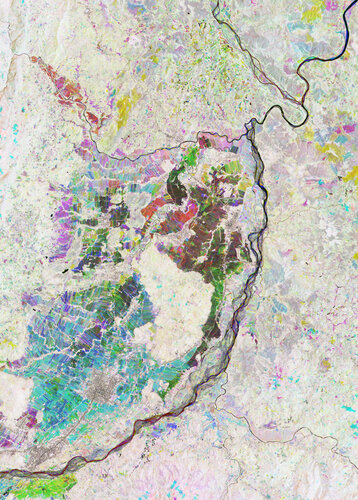 Image:
The heart of the Nueva Vizcaya Province on Luzon, the largest and most populated island of the Philippines, shows up brightly in this Copernicus Sentinel-2 false-colour image.
Image:
The heart of the Nueva Vizcaya Province on Luzon, the largest and most populated island of the Philippines, shows up brightly in this Copernicus Sentinel-2 false-colour image.
Odstávka Geoportálu ČÚZK
6.10.2023 10:00 ČÚZK - Geoportál Odstávka Geoportálu ČÚZKOd pátku 20.10.2023, od 15:00 do 17:00 je plánována odstávka Geoportálu ČÚZK, tj. informačních stránek i všech poskytovaných služeb.
Předem se omlouváme všem uživatelům za vzniklé potíže.
Děkujeme za pochopení, Váš team Geoportál.
Breaking into space entrepreneurship with "Cassini Challenges"
6.10.2023 9:22 European GNSS Agency is the one stop shop for both experienced and inexperienced innovators who want to break into the space industry!")
Space has become one of the most exciting ecosystems to generate revenue. Yet, when most people hear the term "space business" the first thing that pops into their head is a rocket blasting off of a launch pad and a control room.
"And yes, part of space business is about sending rovers to Mars and putting satellites in orbit but there is so much more that space technology can offer." explains Fiammetta Diani, head at EUSPA Market, Downstream & Innovation Department. "Thanks to the large amount of Earth Observation, satellite navigation and satcom data offered by satellites we can develop myriads of applications to serve millions of users down on Earth," she adds.
A "downstream space entrepreneur" can be anyone from any sector that is looking into space data to innovate and add value to their or someone else’s business model. It could be a startup monitoring the environmental impact of tourism using Earth Observation data or a drone operator integrating secured satellite navigation services to deliver first aid products.
According to Diani, space downstream entrepreneurs are able to find solutions to problems that have not been solved before and reap the rewards associated by being early movers.
Now, one can wonder: How? And with what cost?
Commercialising space technology with CASSINI Challenges
EUSPA has an answer to that, and it’s now called CASSINI Challenges!
The Cassini Challenge (formerly known as #myeuspace competition) is the one stop shop for both experienced and inexperienced innovators who want to break into the space industry. It is a competition which tasks innovators with developing cutting-edge solutions to solve some of today’s most pressing societal issues using satellite data/services from Galileo and Copernicus. The reward? A cash prize pool of 1,000,000 euros to take their solution to the next level.
The competition consists of three thematic challenges and three tracks (based on the maturity of the solution proposed) encourage even more innovators to participate:
- Next Generation Challenge: applicants are asked to leverage Galileo and Copernicus data to craft value adding solutions to improve the well-being, safety, security and connectivity of EU citizens.
- Sustainable Future Challenge: participants are tasked with developing innovative solutions for the conservation of ecosystems, sustainable agriculture and management of energy and resources.
- Emerging Technologies Challenge: innovators must develop disruptive solutions combining EU space data with deep technologies such as Artificial Intelligence (AI), Quantum technologies (quantum computing, sensing, simulation, encryption, etc.), Blockchain technology and Extended Reality or the Metaverse (Augmented Reality (AR), Mixed Reality (MR), Virtual Reality (VR).
Throughout the competition, EUSPA Market Development professionals will offer guidance to participants through dedicated webinars. Participants will also have access to a wealth of tools and publications of space intelligence generated by EUSPA such as the EUSPA EO and GNSS Marker Report and the EU Space For Green Transformation report, among others.
The Cassini Challenges are open to teams from the EU27 plus Switzerland, Norway and Iceland.
Media note: This feature can be republished without charge provided the European Union Agency for the Space Programme (EUSPA) is acknowledged as the source at the top or the bottom of the story. You must request permission before you use any of the photographs on the site. If you republish, we would be grateful if you could link back to the EUSPA website (http://www.euspa.europa.eu).
Breaking into space entrepreneurship with "Cassini Challenges"
6.10.2023 9:22 European GNSS AgencySpace has become one of the most exciting ecosystems to generate revenue. Yet, when most people hear the term "space business" the first thing that pops into their head is a rocket blasting off of a launch pad and a control room.
"And yes, part of space business is about sending rovers to Mars and putting satellites in orbit but there so much more than space technology can offer." explains Fiammetta Diani, head at EUSPA Market, Downstream & Innovation Department. "Thanks to the large amount of Earth Observation, satellite navigation and satcom data offered by satellites we can develop myriads of applications to serve millions of users down on Earth," she adds.
A "downstream space entrepreneur" can be anyone from any sector that is looking into space data to innovate and add value to their or someone else’s business model. It could be a startup monitoring the environmental impact of tourism using Earth Observation data or a drone operator integrating secured satellite navigation services to deliver first aid products.
According to Diani, space downstream entrepreneurs are able to find solutions to problems that have not been solved before and reap the rewards associated by being early movers.
Now, one can wonder: How? And with what cost?
Commercialising space technology with CASSINI Challenges
EUSPA has an answer to that, and it’s now called CASSINI Challenges!
The Cassini Challenge (formerly known as #myeuspace competition) is the one stop shop for both experienced and inexperienced innovators who want to break into the space industry. It is a competition which tasks innovators with developing cutting-edge solutions to solve some of today’s most pressing societal issues using satellite data/services from Galileo and Copernicus. The reward? A cash prize pool of 1,000,000 euros to take their solution to the next level.
The competition consists of three thematic challenges and three tracks (based on the maturity of the solution proposed) encourage even more innovators to participate:
- Next Generation Challenge: applicants are asked to leverage Galileo and Copernicus data to craft value adding solutions to improve the well-being, safety, security and connectivity of EU citizens.
- Sustainable Future Challenge: participants are tasked with developing innovative solutions for the conservation of ecosystems, sustainable agriculture and management of energy and resources.
- Emerging Technologies Challenge: innovators must develop disruptive solutions combining EU space data with deep technologies such as Artificial Intelligence (AI), Quantum technologies (quantum computing, sensing, simulation, encryption, etc.), Blockchain technology and Extended Reality or the Metaverse (Augmented Reality (AR), Mixed Reality (MR), Virtual Reality (VR).
Throughout the competition, EUSPA Market Development professionals will offer guidance to participants through dedicated webinars. Participants will also have access to a wealth of tools and publications of space intelligence generated by EUSPA such as the EUSPA EO and GNSS Marker Report and the EU Space For Green Transformation report, among others.
The Cassini Challenges are open to teams from the EU27 plus Switzerland, Norway and Iceland.
Media note: This feature can be republished without charge provided the European Union Agency for the Space Programme (EUSPA) is acknowledged as the source at the top or the bottom of the story. You must request permission before you use any of the photographs on the site. If you republish, we would be grateful if you could link back to the EUSPA website (http://www.euspa.europa.eu).
rada/odborný rada - ředitel/ka Technické sekce
6.10.2023 9:02 ČÚZK - volná místa Katastrální úřad pro Jihomoravský kraj technická sekce vypisuje výběrové řízení na místo rada/odborný rada - ředitel/ka Technické sekcerada/odborný rada - ředitel/ka Technické sekce
6.10.2023 9:02 ČÚZK - předpisy a opatření Katastrální úřad pro Jihomoravský kraj technická sekcevypisuje výběrové řízení na místo
rada/odborný rada - ředitel/ka Technické sekce
rada/odborný rada - ředitel/ka Technické sekce
6.10.2023 9:02 ČÚZK /Urady/Katastralni-urady/Katastralni-urady/Katastralni-urad-pro-Jihomoravsky-kraj/Uredni-deska/Oznameni-a-jina-uredni-sdeleni/Volna-mista/DMS/rada-odborny-rada-reditel-ka-Technicke-sekce2231006-VŘ KP Karviná
6.10.2023 8:52 ČÚZK - předpisy a opatření Český úřad zeměměřický a katastrální zveřejnil novou aktualitu: Oznámení o vyhlášení výběrového řízení na obsazení služebního místa ředitele/ ředitelky Katastrálního pracoviště Karviná.2231006-VŘ KP Karviná
6.10.2023 8:52 ČÚZK - aktuality v resortu Oznámení o vyhlášení výběrového řízení na obsazení služebního místa ředitele/ ředitelky Katastrálního pracoviště Karviná.2231006-VŘ KP Karviná
6.10.2023 8:52 ČÚZK - předpisy a opatření Český úřad zeměměřický a katastrálnízveřejnil novou aktualitu: Oznámení o vyhlášení výběrového řízení na obsazení služebního místa ředitele/ ředitelky Katastrálního pracoviště Karviná.
2231006-VŘ KP Karviná
6.10.2023 8:52 ČÚZK - předpisy a opatření Český úřad zeměměřický a katastrální zveřejnil novou aktualitu: Oznámení o vyhlášení výběrového řízení na obsazení služebního místa ředitele/ ředitelky Katastrálního pracoviště Karviná.2231006-VŘ KP Karviná
6.10.2023 8:52 ČÚZK - aktuality v resortu Oznámení o vyhlášení výběrového řízení na obsazení služebního místa ředitele/ ředitelky Katastrálního pracoviště Karviná.2231006-VŘ KP Karviná
6.10.2023 8:52 ČÚZK - aktuality v resortu Oznámení o vyhlášení výběrového řízení na obsazení služebního místa ředitele/ ředitelky Katastrálního pracoviště Karviná.2231006-VŘ KP Karviná
6.10.2023 8:52 ČÚZK - aktuality v resortu Oznámení o vyhlášení výběrového řízení na obsazení služebního místa ředitele/ ředitelky Katastrálního pracoviště Karviná.2231006-VŘ KP Karviná
6.10.2023 8:52 ČÚZK - předpisy a opatření Český úřad zeměměřický a katastrálnízveřejnil novou aktualitu: Oznámení o vyhlášení výběrového řízení na obsazení služebního místa ředitele/ ředitelky Katastrálního pracoviště Karviná.
Harmonizing satnav for aviation: SBAS experts meet
6.10.2023 8:38 ESA Navigation
More than 150 000 aircraft and 5000 airports worldwide are equipped with Satellite-based Augmentation System (SBAS) technology for safer flying. Specialists overseeing these systems met from 19 to 21 September for the 38th SBAS Interoperability Working Group meeting, hosted by ESA in Toulouse, to coordinate efforts for seamless navigation.
Nová verze DAEX DESIGN 24 již v naší nabídce!
5.10.2023 17:55 ŠPINAR - softwareNová verze DAEX DESIGN 24 již brzy na našich internetových stránkách
The post Nová verze DAEX DESIGN 24 již v naší nabídce! appeared first on ŠPINAR – software.
Nová verze DAEX DESIGN 24 již v naší nabídce!
5.10.2023 17:55 ŠPINAR - softwareNová verze DAEX DESIGN 24 již brzy na našich internetových stránkách
The post Nová verze DAEX DESIGN 24 již v naší nabídce! appeared first on ŠPINAR – software.
Nová verze DAEX DESIGN 24 již v naší nabídce!
5.10.2023 17:55 ŠPINAR - softwareNová verze DAEX DESIGN 24 uvedena na trhu v České a Slovenské republice
The post Nová verze DAEX DESIGN 24 již v naší nabídce! appeared first on ŠPINAR – software.
Nová verze DAEX DESIGN 24 již v naší nabídce!
5.10.2023 17:55 ŠPINAR - softwareNová verze DAEX DESIGN 24 uvedena na trhu!
The post Nová verze DAEX DESIGN 24 již v naší nabídce! appeared first on ŠPINAR – software.
Nová verze DAEX DESIGN 24 již v naší nabídce!
5.10.2023 17:55 ŠPINAR - softwareNová verze DAEX DESIGN 24 uvedena na trhu v České a Slovenské republice
The post Nová verze DAEX DESIGN 24 již v naší nabídce! appeared first on ŠPINAR – software.
Nová verze DAEX DESIGN 24 již v naší nabídce!
5.10.2023 17:55 ŠPINAR - software Nová verze DAEX DESIGN 24 uvedena na trhu!odborný rada - vedoucí oddělení právních vztahů k nemovitostem Katastrálního pracoviště Náchod
5.10.2023 13:24 ČÚZK - volná místa Katastrální úřad pro Královéhradecký kraj Katastrální pracoviště Náchod vypisuje výběrové řízení na místo odborný rada - vedoucí oddělení právních vztahů k nemovitostem Katastrálního pracoviště Náchododborný rada - vedoucí oddělení právních vztahů k nemovitostem Katastrálního pracoviště Náchod
5.10.2023 13:24 ČÚZK - předpisy a opatření Katastrální úřad pro Královéhradecký kraj Katastrální pracoviště Náchodvypisuje výběrové řízení na místo
odborný rada - vedoucí oddělení právních vztahů k nemovitostem Katastrálního pracoviště Náchod
odborný rada - vedoucí oddělení právních vztahů k nemovitostem Katastrálního pracoviště Náchod
5.10.2023 13:24 ČÚZK /Urady/Katastralni-urady/Katastralni-urady/Katastralni-urad-pro-Kralovehradecky-kraj/Uredni-deska/Oznameni-a-jina-uredni-sdeleni/Volna-mista/DMS/odborny-rada-vedouci-oddeleni-pravnich-vztahu-(1)referent majetkové správy Katastrálního úřadu pro Královéhradecký kraj
5.10.2023 13:21 ČÚZK /Urady/Katastralni-urady/Katastralni-urady/Katastralni-urad-pro-Kralovehradecky-kraj/Volna-mista/DMS/referent-majetkove-spravy-Katastralniho-uradu-pro-referent majetkové správy Katastrálního úřadu pro Královéhradecký kraj
5.10.2023 13:21 ČÚZK - předpisy a opatření Katastrální úřad pro Královéhradecký kraj kancelář ředitelevypisuje výběrové řízení na místo
referent majetkové správy Katastrálního úřadu pro Královéhradecký kraj
referent majetkové správy Katastrálního úřadu pro Královéhradecký kraj
5.10.2023 13:21 ČÚZK - volná místa Katastrální úřad pro Královéhradecký kraj kancelář ředitele vypisuje výběrové řízení na místo referent majetkové správy Katastrálního úřadu pro Královéhradecký krajYounger trees champion carbon capture
5.10.2023 11:00 ESA Observing the Earth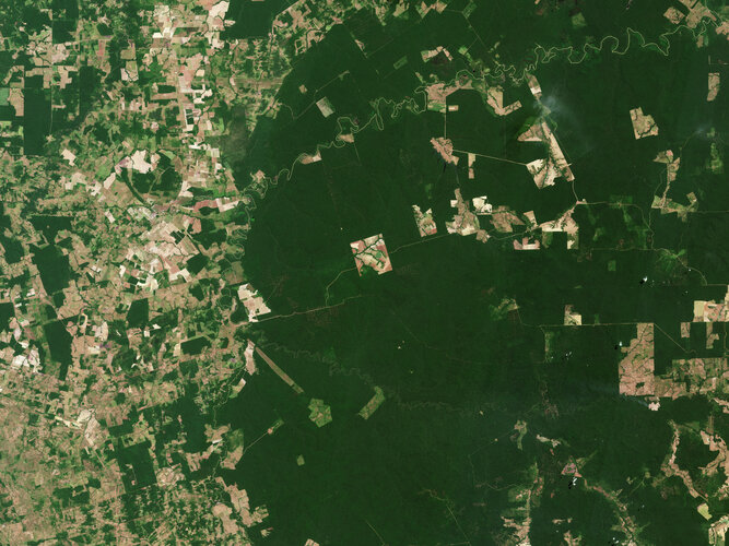
Thanks to their ability to absorb and store carbon dioxide from the atmosphere, forests have long been recognised as a key tool in the fight against climate change – but not all forests are equal. New research based on data from ESA’s SMOS satellite mission has found that, surprisingly, young trees are champions at carbon capture.
Uno, dos, tres… Registrations for EU Space Week are open!
4.10.2023 16:04 European GNSS Agency
Organised by the EU Agency for the Space Programme and the European Commission, under the auspices of the Spanish Presidency of the Council of the European Union, the EU Space Week 2023 is taking place in Sevilla from the 7th to 9th of November. The top European Union space conference is a unique opportunity to get an up-close look at how European businesses – and society in general – benefit from the EU Space Programme.
"The EU Space Week is the hallmark of the European space sector, bringing together top policy and decision makers across the EU, scientists, space industry experts and entrepreneurs from all walks of life. It’s a platform where actors involved or interested in the EU Space Programme can share knowledge, experiences and reflect on how we can improve the services currently offered by Galileo, EGNOS, Copernicus and GOVSATCOM/IRIS2. I am excited to announce that the registrations for the EU Space Week 2023 are officially open as of today! I look forward to welcoming you all in Sevilla" remarked EUSPA Executive Director Rodrigo da Costa.
REGISTER HERE
What to expect?
While more details will be revealed in the coming weeks, here’s a sneak peek of what awaits you:
- Keynote speeches by Diana Morant, Minister of Science and Innovation and Thierry Breton, European Commissioner for Internal Market
- New and insightful sessions including sessions on Space Traffic Management and Space Security
- New ways to do space and innovate
- Live demonstrations of applications powered by the EU Space Programme
- Social events and networking opportunities
Latitude: 37.40347465 Longitude: -5.93310621
The EU Space Week will be hosted at the Fibes Conference and Exhibition centre, just two kilometres from the picturesque city of Sevilla.
To find your way to the conference centre use your Galileo-enabled, mobile phone or wearable.
Can’t make it to Sevilla? No worries, we will be livestreaming the event.
The EU Space Week is jointly organised by the European Commission and the EU Agency for the Space Programme (EUSPA) and held under the auspices of the Spanish Presidency of the Council of European Union.
Make sure you follow EUSPA (@EU4Space), DG DEFIS (@DEFIS_eu), and the Spanish Presidency (@eu2023es) on Twitter for updates.
Media note: This feature can be republished without charge provided the European Union Agency for the Space Programme (EUSPA) is acknowledged as the source at the top or the bottom of the story. You must request permission before you use any of the photographs on the site. If you republish, we would be grateful if you could link back to the EUSPA website (http://www.euspa.europa.eu).
Ozone hole goes large again
4.10.2023 15:40 ESA Observing the Earth
Measurements from the Copernicus Sentinel-5P satellite show that this year’s ozone hole over Antarctica is one of the biggest on record. The hole, which is what scientists call an ‘ozone depleting area,’ reached a size of 26 million sq km on 16 September 2023. This is roughly three times the size of Brazil.
Noc vědců [Knihovna geografie, byTopic]
4.10.2023 12:00 Katedra aplikované geoinformatiky a kartografie Přf UK Navštivte různá muzea, sbírky nebo přednášky i s geografickou tématikouRada/odborný rada – obnova katastrálního operátu
4.10.2023 10:33 ČÚZK - volná místa Katastrální úřad pro Moravskoslezský kraj Katastrální pracoviště Ostrava vypisuje výběrové řízení na místo Rada/odborný rada – obnova katastrálního operátuRada/odborný rada – obnova katastrálního operátu
4.10.2023 10:33 ČÚZK - předpisy a opatření Katastrální úřad pro Moravskoslezský kraj Katastrální pracoviště Ostravavypisuje výběrové řízení na místo
Rada/odborný rada – obnova katastrálního operátu
Změna otevírací doby knihovny 4. 10. 2023 [Knihovna geografie, byTopic]
4.10.2023 10:30 Katedra aplikované geoinformatiky a kartografie Přf UK Z provozních důvodů je Knihovna geografie otevřena ve středu 4. 10. 2023 pouze do 16:00.Rada/odborný rada – ředitel/ka
4.10.2023 10:13 ČÚZK /Urady/Katastralni-urady/Katastralni-urady/Katastralni-urad-pro-Moravskoslezsky-kraj/Uredni-deska/Oznameni-a-jina-uredni-sdeleni/Volna-mista/DMS/Rada-odborny-rada-–-reditel-kaRada/odborný rada – ředitel/ka
4.10.2023 10:13 ČÚZK - volná místa Katastrální úřad pro Moravskoslezský kraj Katastrální pracoviště Karviná vypisuje výběrové řízení na místo Rada/odborný rada – ředitel/kaRada/odborný rada – ředitel/ka
4.10.2023 10:13 ČÚZK - předpisy a opatření Katastrální úřad pro Moravskoslezský kraj Katastrální pracoviště Karvinávypisuje výběrové řízení na místo
Rada/odborný rada – ředitel/ka
Známe program letošní Konference GIS Esri v ČR
4.10.2023 8:53 GISportal.cz
Společnost ARCDATA PRAHA zveřejnila program letošní Konference GIS Esri v ČR, která proběhne 8. a 9. listopadu v Praze. My se na akci i letos chystáme a budeme průběžně reportovat pod #EsriCZ – budeme rádi, když se k nám přidáte! Mimo hlavní řečníky, se můžete těšit na tyto sekce a přednášky: Technologie, novinky, aktuality Trends […]
The post Známe program letošní Konference GIS Esri v ČR appeared first on GISportal.cz.
Známe program letošní Konference GIS Esri v ČR
4.10.2023 8:53 GISportal.czSpolečnost ARCDATA PRAHA zveřejnila program letošní Konference GIS Esri v ČR, která proběhne 8. a 9. listopadu v Praze. My se na akci i letos chystáme a budeme průběžně reportovat pod #EsriCZ – budeme rádi, když se k nám přidáte! Mimo hlavní řečníky, se můžete těšit na tyto sekce a přednášky: Technologie, novinky, aktuality Trends […]
The post Známe program letošní Konference GIS Esri v ČR appeared first on GISportal.cz.
Laserové skenování Čiperovy vily
3.10.2023 14:30 Hrdlička V létě roku 2021 jsme provedli zaměření této racionálně klasicistní vily ve Zlíně.Přerušení provozu DP a WSDP v pátek 6.10.2023 od 18:00 do cca 20:00.
3.10.2023 13:07 Dálkový přístup k údajům KN ČR Vážení uživatelé,oznamujeme, že v pátek 6.10.2023 od 18:00 bude z provozních důvodů zcela přerušen provoz Dálkového přístupu i Webových služeb dálkového přístupu. Obnovení provozu předpokládáme v cca 20 hodin. U této verze nedochází ke změnám webových služeb.
Za komplikace tímto způsobené se omlouváme a děkujeme za pochopení.
Přerušení provozu DP a WSDP v pátek 6.10.2023 od 18:00 do cca 20:00.
3.10.2023 13:07 ČÚZK /Aplikace-DP-do-KN/Aplikace-DP-do-KN/Archiv-DP/396723Přerušení provozu DP a WSDP v pátek 6.10.2023 od 18:00 do cca 20:00.
3.10.2023 13:07 ČÚZK - předpisy a opatření Vážení uživatelé,oznamujeme, že v pátek 6.10.2023 od 18:00 bude z provozních důvodů zcela přerušen provoz Dálkového přístupu i Webových služeb dálkového přístupu. Obnovení provozu předpokládáme v cca 20 hodin. U této verze nedochází ke změnám webových služeb.
Za komplikace tímto způsobené se omlouváme a děkujeme za pochopení.
Rada / odborný rada - vedoucí oddělení právních vztahů k nemovitostem Katastrálního pracoviště Valaš
3.10.2023 12:30 ČÚZK /Urady/Katastralni-urady/Katastralni-urady/Katastralni-urad-pro-Zlinsky-kraj/Uredni-deska/Oznameni-a-jina-uredni-sdeleni/Volna-mista/DMS/Rada-odborny-rada-vedouci-oddeleni-pravnich-vztahuRada / odborný rada - vedoucí oddělení právních vztahů k nemovitostem Katastrálního pracoviště Valaš
3.10.2023 12:30 ČÚZK - volná místa Katastrální úřad pro Zlínský kraj Katastrální pracoviště Valašské Klobouky vypisuje výběrové řízení na místo Rada / odborný rada - vedoucí oddělení právních vztahů k nemovitostem Katastrálního pracoviště ValašRada / odborný rada - vedoucí oddělení právních vztahů k nemovitostem Katastrálního pracoviště Valaš
3.10.2023 12:30 ČÚZK - předpisy a opatření Katastrální úřad pro Zlínský kraj Katastrální pracoviště Valašské Kloboukyvypisuje výběrové řízení na místo
Rada / odborný rada - vedoucí oddělení právních vztahů k nemovitostem Katastrálního pracoviště Valašské Klobouky
OÚ KO Stará Ľubovňa - oznam
3.10.2023 10:03
ÚGKK SR
Oznamujeme Vám, že dňa 03.10.2023 nebudú vykonávané úkony na Okresnom úrade Stará Ľubovňa, katastrálny odbor, z technických príčin /porucha servera/.
Podzimní sleva 33 % na Fusion 360
3.10.2023 8:59 Adeon
Autodesk ohlásil novou akci pro licence aplikace Fusion 360. V rámci akce lze pořídit nové licence se slevou 33 %. […]
The post Podzimní sleva 33 % na Fusion 360 appeared first on Adeon CZ.
Podzimní sleva 33 % na Fusion 360
3.10.2023 8:59 AdeonAutodesk ohlásil novou akci pro licence aplikace Fusion 360. V rámci akce lze pořídit nové licence se slevou 33 %. […]
The post Podzimní sleva 33 % na Fusion 360 appeared first on Adeon CZ.
Podzimní sleva 33 % na Fusion 360
3.10.2023 8:59 AdeonAutodesk ohlásil novou akci pro licence aplikace Fusion 360. V rámci akce lze pořídit nové licence se slevou 33 %. […]
The post Podzimní sleva 33 % na Fusion 360 appeared first on Adeon CZ.
Říjnová sleva 33 % na oblíbenou aplikaci Autodesk Fusion 360
3.10.2023 0:00 Arkance SystemsZískejte slevu na nové roční předplatné 3D CAD/CAM aplikace Autodesk Fusion 360. Akce trvá do 31. října 2023.
Zpráva Říjnová sleva 33 % na oblíbenou aplikaci Autodesk Fusion 360 pochází z arkance-systems.cz.
Odstávka mapových aplikací Geoportálu
2.10.2023 13:41 Jihočeský krajV pátek 6.10.2023 od 15:30 budou z technických důvodů nedostupné mapové aplikace Geoportálu. Obnovení plného provozu předpokládáme po 23:00.
rnrnOmlouváme se za komplikace
Reinforcing European space autonomy with the EU Space Information Sharing Centre (ISAC)
2.10.2023 13:06 European GNSS Agency
Space plays a crucial role in EU strategic autonomy, economy, citizens’ welfare, security and defence, scientific development and other vital areas. Considering the Union’s increasing reliance on space data and services, safeguarding the security of space systems and the communication and information networks they rely upon is of utmost importance.
On March 2023, the European Commissioner for Internal Market, Thierry Breton and the High Representative, Josep Borrel presented in March 2023 the first-ever EU Space Strategy for Security and Defence. The strategy is a direct implementation of the EU Strategic Compass adopted less than a year ago and which defined space, together with cyber and maritime, as contested strategic domains, the security of which must be ensured.
The strategy foresees -among others- the creation of a Sharing and Analysis Centre (EU Space ISAC) to raise awareness and facilitate the exchange of best practices among commercial and relevant public entities on resilience measures for space capabilities.
Increasing EUSPA’s security responsibilities
EUSPA has a large portfolio to deliver on, which includes the security of the EU Space Programme and its components in space and on the ground. The agency guarantees that Europe’s positioning systems, Galileo and EGNOS emit secure signals and that their respective ground infrastructures (sensors, antennas, stations) remain intact. It does so by performing risk and threat analysis and monitoring the compliance to the general security requirements of the space components.
Moreover, EUSPA provides security expertise to other components of the Space Programme, such as GOVSATCOM and the Space Situational Awareness.
As of June 2023, the agency also manages the EU Space Surveillance and Tracking (SST) Front Desk. Highly qualified EUSPA staff interfaces with spacecraft owners and operators, EU institutions and EU Member States and supports them in using the web portal and the services SST offers.
Read this: EUSPA grows further to support EU Space Traffic Management
“Working towards the establishment of the EU space ISAC is an important task for our agency, and we are proud to work with the European Commission on this’’ says EUSPA Executive Director Rodrigo da Costa. “Given our excellence in managing the operational security of Galileo and our new role in the EU SST, we are excited to be able to share our knowledge with interested stakeholders and contribute to a safer and more secure EU space.’’ he concludes.
So, what is the EU space Sharing and Analysis Centre?
The EU Space ISAC will be membership-driven organisation, engaging industry, public sector institutions and academia. The main objective of it is to contribute to the security and resilience of space systems and their supply chain.
It will serve as the primary communication channel for the space sector with regard to security related information and sharing of best practices, and will provide relevant knowledge, services and resources to enable participants to prevent, tackle and mitigate security challenges to the space sector more effectively and efficiently.
The centre will be composed of “Members'”, which can include Small and Medium Enterprises (SMEs), startups and academia. It will also include the so called “Public partners,’’ i.e., legal public entities of relevance for the EU Space sector and which are directly or indirectly contributing to the activity and regulation of ISAC.
Why Participate?
• Stay Informed: engage in information sharing about security related information, incidents*, cyber trends, vulnerabilities, and threats.
• Stay Ahead: benefit from early warning systems, getting timely alerts on security threats, enabling swift responses.
• Develop Together: enhance collective cybersecurity resilience through knowledge sharing, best practices, and expertise pooling.
• Access Expertise: engage with cybersecurity experts, public sector agencies, and other stakeholders for guidance and support.
• Network: build connections with industry peers and public partners, fostering collaborative solutions to common challenges.
Analytical information can be found here.
We encourage applicants to read carefully the call before submitting.
Media note: This feature can be republished without charge provided the European Union Agency for the Space Programme (EUSPA) is acknowledged as the source at the top or the bottom of the story. You must request permission before you use any of the photographs on the site. If you republish, we would be grateful if you could link back to the EUSPA website (http://www.euspa.europa.eu).
20231002_Odborný / vrchní referent oddělení aktualizace PI KN I.
2.10.2023 10:29 ČÚZK /Urady/Katastralni-urady/Katastralni-urady/Katastralni-urad-pro-Stredocesky-kraj/Katastralni-pracoviste/KP-Praha-vychod/O-uradu/Aktuality/20210922_Odborny-referent-oddeleni-aktualizace-(4)20231002_Odborný / vrchní referent oddělení aktualizace PI KN I.
2.10.2023 10:29 ČÚZK - předpisy a opatření Katastrální úřad pro Středočeský kraj - Katastrální pracoviště Praha-východ Vyhlášení výběrového řízení: Odborný / vrchní referent oddělení aktualizace PI KN I. V části "Úřední deska", v sekci "Oznámení a jiná úřední sdělení" bylo vystaveno "Oznámení o vyhlášení výběrového řízení na obsazení služebního místa Odborný / vrchní referent oddělení aktualizace PI KN I."Nová verze DAEX DESIGN 24 již brzy!
30.9.2023 14:11 ŠPINAR - softwareNová verze DAEX DESIGN 24 již brzy na našich internetových stránkách
The post Nová verze DAEX DESIGN 24 již brzy! appeared first on ŠPINAR – software.
Nová verze DAEX DESIGN 24 již brzy!
30.9.2023 14:11 ŠPINAR - softwareReferenční články na využívání programů DAEX DESIGN pro interiéry, nábytek a truhlářskou výrobu
The post Nová verze DAEX DESIGN 24 již brzy! appeared first on ŠPINAR – software.