


![]()

zprávy
zdroje zpráv:Vrchní referent/rada v právním oddělení č.2 na Katastrálním pracovišti Brno - město
6.4.2022 11:48 ČÚZK - volná místa Katastrální úřad pro Jihomoravský kraj Katastrální pracoviště Brno-město vypisuje výběrové řízení na místo Vrchní referent/rada v právním oddělení č.2 na Katastrálním pracovišti Brno - městoVrchní referent/rada v právním oddělení č.2 na Katastrálním pracovišti Brno - město
6.4.2022 11:48 ČÚZK - předpisy a opatření Katastrální úřad pro Jihomoravský kraj Katastrální pracoviště Brno-městovypisuje výběrové řízení na místo
Vrchní referent/rada v právním oddělení č.2 na Katastrálním pracovišti Brno - město
Rada/odborný rada - vedoucí oddělení aktualizace PI KN na Katastrálním pracovišti Brno - město
6.4.2022 11:10 ČÚZK - volná místa Katastrální úřad pro Jihomoravský kraj Katastrální pracoviště Brno-město vypisuje výběrové řízení na místo Rada/odborný rada - vedoucí oddělení aktualizace PI KN na Katastrálním pracovišti Brno - městoRada/odborný rada - vedoucí oddělení aktualizace PI KN na Katastrálním pracovišti Brno - město
6.4.2022 11:10 ČÚZK - předpisy a opatření Katastrální úřad pro Jihomoravský kraj Katastrální pracoviště Brno-městovypisuje výběrové řízení na místo
Rada/odborný rada - vedoucí oddělení aktualizace PI KN na Katastrálním pracovišti Brno - město
Rada/odborný rada - vedoucí oddělení aktualizace PI KN na Katastrálním pracovišti Brno - město
6.4.2022 11:10 ČÚZK /Urady/Katastralni-urady/Katastralni-urady/Katastralni-urad-pro-Jihomoravsky-kraj/Uredni-deska/Oznameni-a-jina-uredni-sdeleni/Volna-mista/DMS/Rada-odborny-rada-vedouci-oddeleni-aktualizace-PRada / odborný rada - vedoucí oddělení aktualizace KN Katastrálního pracoviště Valašské Meziříčí
6.4.2022 11:03 ČÚZK - volná místa Katastrální úřad pro Zlínský kraj Katastrální pracoviště Valašské Meziříčí vypisuje výběrové řízení na místo Rada / odborný rada - vedoucí oddělení aktualizace KN Katastrálního pracoviště Valašské MeziříčíRada / odborný rada - vedoucí oddělení aktualizace KN Katastrálního pracoviště Valašské Meziříčí
6.4.2022 11:03 ČÚZK /Urady/Katastralni-urady/Katastralni-urady/Katastralni-urad-pro-Zlinsky-kraj/Uredni-deska/Oznameni-a-jina-uredni-sdeleni/Volna-mista/DMS/Rada-odborny-rada-vedouci-oddeleni-aktualizaceRada / odborný rada - vedoucí oddělení aktualizace KN Katastrálního pracoviště Valašské Meziříčí
6.4.2022 11:03 ČÚZK - předpisy a opatření Katastrální úřad pro Zlínský kraj Katastrální pracoviště Valašské Meziříčívypisuje výběrové řízení na místo
Rada / odborný rada - vedoucí oddělení aktualizace KN Katastrálního pracoviště Valašské Meziříčí
Rozpočet úřadu za rok 2022
6.4.2022 9:58 ČÚZK /Urady/Katastralni-urady/Katastralni-urady/Katastralni-urad-pro-Pardubicky-kraj/Rozpocet/Rozpocet-uradu-za-rok-2022Rozpočet úřadu za rok 2022
6.4.2022 9:58 ČÚZK - předpisy a opatření Katastrální úřad pro Pardubický krajvystavuje rozpočet úřadu za rok
2022
406 Day: how Galileo helps save lives
6.4.2022 9:45 ESA Navigation
Today is the annual 406 Day, celebrating the life-saving importance of emergency beacons, named for the radio frequency they operate on, as well as the satellites that relay their signals – with Europe’s own Galileo constellation prominent among them. While Galileo’s main purpose is satellite navigation, the system also picks up distress messages from across the globe and relays them to regional search and rescue authorities.
Utilitní Jihlava
6.4.2022 9:33 blog ARCDATA V roce 2021 se Jihlava stala novým vlastníkem vodohospodářské infrastruktury na svém území – sta kilometrů vedení a tisíců objektů, které je nutné podrobně evidovat, sledovat a pracovat s nimi. Na oddělení GIS Magistrátu města Jihlavy jsme tak stáli před nesnadným úkolem prakticky na zelené louce vybudovat funkční systém pro správu celé této infrastruktury.Interview with Elliott S Ferguson, VP Geospatial Solutions, Hexagon US Federal
6.4.2022 9:00 GISCafe.com Webcasts-WebinarsProdej automobilu Octavia v aukci na ÚZSVM
6.4.2022 8:36 ČÚZK /Urady/Katastralni-urady/Katastralni-urady/Katastralni-urad-pro-Liberecky-kraj/Nabidky-majetku/Prodej-automobilu-Octavia-v-aukci-na-UZSVMProdej automobilu Octavia v aukci na ÚZSVM
6.4.2022 8:36 ČÚZK - předpisy a opatřeníKatastrální úřad pro Liberecký kraj Prodej automobilu Octavia v aukci na ÚZSVM
Prodej automobilu Octavia v aukci na ÚZSVM
Prodej automobilu Fabia v aukci na ÚZSVM
6.4.2022 8:34 ČÚZK /Urady/Katastralni-urady/Katastralni-urady/Katastralni-urad-pro-Liberecky-kraj/Nabidky-majetku/Prodej-automobilu-Fabia-v-aukci-na-UZSVMProdej automobilu Fabia v aukci na ÚZSVM
6.4.2022 8:34 ČÚZK - předpisy a opatřeníKatastrální úřad pro Liberecký kraj Prodej automobilu Fabia v aukci na ÚZSVM
Prodej automobilu Fabia v aukci na ÚZSVM
Rozpočet úřadu za rok 2022
6.4.2022 7:36 ČÚZK /Urady/Katastralni-urady/Katastralni-urady/Katastralni-urad-pro-Ustecky-kraj/Rozpocet/Rozpocet-uradu-za-rok-2022Rozpočet úřadu za rok 2022
6.4.2022 7:36 ČÚZK - předpisy a opatření Katastrální úřad pro Ústecký krajvystavuje rozpočet úřadu za rok
2022
Rozpočet úřadu za rok 2022
6.4.2022 7:36 ČÚZK - předpisy a opatření Katastrální úřad pro Ústecký krajvystavuje rozpočet úřadu za rok 2022
2022
For three days Amsterdam was the UAV capital of the world
5.4.2022 23:59 GISCafe.com Webcasts-Webinars Amsterdam, 4 April 2022Fourth edition of the Amsterdam Drone Week
For three days Amsterdam was the UAV capital of the world
Nearly 3,500 …
Maxar : Satellite Images, 10 & 31 March: Bucha, Ukraine
5.4.2022 23:50 GISCafe.com Webcasts-Webinars European Space Imaging and Maxar collected high resolution satellite imagery of the mass grave which has been identified in the town of Bucha, …CoreLogic and EagleView Expand Relationship to Enhance Claims Processing Automation
5.4.2022 21:59 GISCafe.com Webcasts-Webinars BELLEVUE, Wash., April 05, 2022 (GLOBE NEWSWIRE) -- CoreLogic, a leading global property information, analytics and data-enabled solutions provider …GeoComm Achieves Esri ArcGIS Indoors Specialty Designation
5.4.2022 21:59 GISCafe.com Webcasts-Webinars ST. CLOUD, Minn., April 5, 2022 — (PRNewswire) —This award recognizes GeoComm's expertise in indoor mapping and location …
Satellite Monitoring Technology adds Value to Agro-Consultancy Services, states EOS Data Analytics
5.4.2022 20:24 GISCafe.com Webcasts-Webinars Menlo Park, CA, April 05, 2022 (GLOBE NEWSWIRE) -- Modern agriculture faces an unprecedented challenge — feeding the ever-growing world …Minsait ACS Announces Partnership with Esri
5.4.2022 20:24 GISCafe.com Webcasts-Webinars ATLANTA, April 5, 2022 — (PRNewswire) — Minsait ACS, Inc., a power grid control solutions and technology provider for the electric power …Quanergy 3D LiDAR Flow Management Solution Successfully Deployed by The SFMTA to Reduce Traffic Delays
5.4.2022 16:21 GISCafe.com Webcasts-Webinars Travel time per light rail vehicle was reduced by 66 seconds resulting in a travel time reduction of 16%The chance that a train will reach an …
Welsh Government-Sponsored Living Wales Research Project Leverages Planet Data For Green Agricultural Policies
5.4.2022 16:21 GISCafe.com Webcasts-Webinars SAN FRANCISCO — (BUSINESS WIRE) — April 5, 2022 —Planet Labs PBC (NYSE: PL), a leading provider of daily data and insights about …
Annual Home Price Growth Again Hits New High in February, CoreLogic Reports
5.4.2022 16:21 GISCafe.com Webcasts-Webinars U.S. home prices jumped by 20% from February 2021Home price growth is projected to slow to 5% over the next 12 months
IRVINE, Calif. — …
Top-10 U.S. Insurer Subscribes to Intermap's InsitePro®
5.4.2022 16:21 GISCafe.com Webcasts-Webinars DENVER, April 5, 2022 — (PRNewswire) — Intermap Technologies (TSX: IMP) (OTCQX: ITMSF) ("Intermap" or the "Company"), a global leader in …Novinky v ArcGIS Online
5.4.2022 13:20 ARCDATAKoncem minulého měsíce vyšla nová verze ArcGIS Online. Připravili jsem si pro vás výběr našich nejoblíbenějších novinek, které stojí za vaši pozornost. Nejvíce vylepšení pravděpodobně naleznete v Map Vieweru.
Seskupování vrstev
Možnost uspořádání vrstev do skupin je uživatelsky velmi oblíbená. Nyní již můžete stejně jako v původním Map Vieweru vytvářet skupiny vrstev podle vašich potřeb.

Změna souřadnicového systému
Jednou z dalších novinek, kterou byste si neměli nechat ujít, je možnost pracovat s mapou v souřadnicovém systému S-JTSK. Tak jako v Map Viewer Classic, i nyní se souřadnicový systém webové mapy řídí systémem podkladové mapy.

Kategorizace uživatelů
Také bychom vás chtěli upozornit na novou možnost vytvořit kategorie pro členy vaší organizace. Tato novinka se vám může hodit, zvláště pokud je vaše organizace rozsáhlá a potřebujete zpřehlednit správu všech zúčastněných.

Nový editační widget
V nové verzi ArcGIS Online a jeho Map Vieweru najdete také vylepšený editační widget. Editace v Map Vieweru i v ArcGIS Field Maps nyní podporuje funkci Calculations – tedy výpočty atributů na základě jazyka Arcade.

Vizualizace vektorů toku
A na závěr bychom chtěli vyzdvihnout metodu zobrazení rastrových dat Tok (Flow Renderer). V novém Map Vieweru totiž najdete možnost vizualizace rastrových dat pomocí jejich atributů UV a MagDir (vektorové pole). Pokud tedy disponujete daty, která obsahují i informaci o směru, určitě doporučujeme tento nástroj využít.

odborný referent/vrchní referent – obnova katastrálního operátu
5.4.2022 12:40 ČÚZK - předpisy a opatření Katastrální úřad pro Olomoucký kraj - Katastrální pracoviště Šumperkvypisuje výběrové řízení na místo
odborný referent/vrchní referent – obnova katastrálního operátu
odborný referent/vrchní referent – obnova katastrálního operátu
5.4.2022 12:40 ČÚZK - volná místa Katastrální úřad pro Olomoucký kraj - Katastrální pracoviště Šumperk vypisuje výběrové řízení na místo odborný referent/vrchní referent – obnova katastrálního operátuOznámení o výběru zástupu na služební místo
5.4.2022 11:11 ČÚZK - předpisy a opatření Katastrální úřad pro Plzeňský kraj - Katastrální pracoviště Rokycany zveřejnil novou aktualitu: Oznámení o výběru zástupu na služební místovrchní referent/rada – kontrola aktualizace KA1301,
oddělení právních vztahů k nemovitostem,
Katastrální úřad pro Plzeňský kraj, Katastrální pracoviště Rokycany
Oznámení o výběru zástupu na služební místo – kontrola aktualizace , oddělení právních vztahů k nemo
5.4.2022 11:08 ČÚZK - volná místa Katastrální úřad pro Plzeňský kraj Katastrální pracoviště Rokycany vypisuje výběrové řízení na místo Oznámení o výběru zástupu na služební místo – kontrola aktualizace , oddělení právních vztahů k nemoOznámení o výběru zástupu na služební místo – kontrola aktualizace , oddělení právních vztahů k nemo
5.4.2022 11:08 ČÚZK - předpisy a opatření Katastrální úřad pro Plzeňský kraj Katastrální pracoviště Rokycanyvypisuje výběrové řízení na místo
Oznámení o výběru zástupu na služební místo – kontrola aktualizace , oddělení právních vztahů k nemovitostem, Katastrální úřad pro Plzeňský kraj, Katastrální pracoviště Rokycany
Oznámení o výběru zástupu na služební místo – kontrola aktualizace , oddělení právních vztahů k nemo
5.4.2022 11:08 ČÚZK /Urady/Katastralni-urady/Katastralni-urady/Katastralni-urad-pro-Plzensky-kraj/Uredni-deska/Oznameni-a-jina-uredni-sdeleni/Volna-mista/DMS/Oznameni-o-vyberu-zastupu-na-sluzebni-misto-–-kontAliance komentuje dlouhodobě pro Českou televizi využívání vojenských dronů při válečných konfliktech
5.4.2022 10:52 UAVAPrezident Aliance dlouhodobě komentuje pro Českou Televizi využití vojenských i komerčních dronů ve válečném konfliktu na Ukrajině a průzkumu u hranic NATO, jako například v speciálu s Danielem Stachem, v Událostech a na ČT24. Využití dronů razantně mění způsob vedení válečných konfliktů a na Ukrajině jsou ve velkém měřítku využívány i dostupné komerční drony…
The post Aliance komentuje dlouhodobě pro Českou televizi využívání vojenských dronů při válečných konfliktech appeared first on UAV Aliance pro bezpilotní letecký průmysl.
Unicorn Systems jako klíčový hráč na evropském poli technologií Esri
5.4.2022 10:04 Unicorn "Rádi bychom vynaložili úsilí na rozšíření našich aktivit po celé Evropě a stali se jedním z klíčových evropských hráčů na poli technologií Esri," říká Managing Director produkčního streamu Miroslav Hašek. Přečtěte si celý rozhovor s Miroslavem o tom, jak se Unicornu daří v oblasti geoinformatiky a jaké jsou naše plány do budoucna.Soutěž Podnikavá hlava již potřinácté pomůže s rozběhnutím podnikání
5.4.2022 10:03 Katedra geoinformatiky UP OlomoucNové kontakty, networking, sdílení zkušeností, konzultace s mentory, ale také 50 tisíc korun do startu podnikání nebo 50% sleva na roční pronájem kanceláře. Nejen to čeká na vítěze soutěže Podnikavá hlava, jejíž třináctý ročník vyhlásil Vědeckotechnický park Univerzity Palackého v Olomouci (VTP UP). Své projekty mohou zájemci přihlašovat do 10. května 2022. Podnikavá hlava je […]
The post Soutěž Podnikavá hlava již potřinácté pomůže s rozběhnutím podnikání appeared first on Katedra geoinformatiky.
Nedostupné produkční prostředí ISÚI a VDP
5.4.2022 9:50 ČÚZK /ruian/Editacni-agendovy-system-ISUI/Provozni-informace-a-odstavky/Archiv-PROD/Nedostupne-produkcni-prostredi-ISUI-a-VDP-(2)Interview with Jodie Gosselin, Director of Geospatial Technologies, Dawood Engineering
5.4.2022 9:00 GISCafe.com Webcasts-WebinarsJarní workshopy s ARCDATA PRAHA – Jak udělat mapu hezčí (PR)
5.4.2022 8:50 GISportal.cz
Společnost ARCDATA PRAHA připravila jarní sérii webových seminářů, zaměřenou na nejrůznější aplikace systému ArcGIS. Vedle tipů pro práci v desktopové aplikaci se seznámíte s postupy pro publikaci vektorových dat online, způsobem, jak je vizualizovat a sdílet formou aplikací nebo interaktivních článků, a také s komplexnějším tématem použití rastrových snímků ve webovém i v desktopovém prostředí. […]
The post Jarní workshopy s ARCDATA PRAHA – Jak udělat mapu hezčí (PR) appeared first on GISportal.cz.
Úprava prohlížecí služby ArcGIS Server - Ortofoto ČR
5.4.2022 7:07 ČÚZK - Geoportál Úprava prohlížecí služby ArcGIS Server - Ortofoto ČRProhlížecí služba ArcGIS Server - Ortofoto ČR byla doplněna o nejpodrobnější měřítkovou úroveň optimalizovaných mapových dlaždic (1 : 472,5). Viz metadata služby.
Tato služba slouží také jako podkladová mapa Ortofoto ČR v aplikaci Geoprohlížeč, kde je po úpravě služby umožněno přiblížení do velmi podrobných měřítek. Aplikace tedy umožňuje plně využít zvýšení rozlišení aktualizovaného produktu Ortofoto ČR, nasnímaného v pásmu Západ s pixelem zobrazujícím 0,125 m území ve střední rovině terénu.
BlackSky Expands Constellation to 14 Satellites and Increases Capacity Over Critical Locations
5.4.2022 3:25 GISCafe.com Webcasts-Webinars HERNDON, Va. — (BUSINESS WIRE) — April 4, 2022 —BlackSky's (NYSE: BKSY) newest satellites successfully began revenue-generating …
Hexagon helps Electricity Company of Ghana modernize electricity distribution
4.4.2022 19:00 Hexagon Safety & InfrastructureTeal Drones Secures Purchase Order for Golden Eagle Drone Units from NATO Member Country for Deployment in Ukraine
4.4.2022 16:01 GISCafe.com Webcasts-Webinars SAN JUAN, Puerto Rico, April 04, 2022 (GLOBE NEWSWIRE) -- Red Cat Holdings, Inc. (Nasdaq: RCAT) ("Red Cat" or the "Company"), a hardware-enabled …BlackSky Appoints Top Defense and Intelligence Experts to New Advisory Group
4.4.2022 16:01 GISCafe.com Webcasts-Webinars Prominent leaders from the Intelligence Community and the Department of Defense: U.S. Army, U.S. Navy, and U.S. Space Force to provide strategic …Esri Releases Annual Update of Ready-to-Use US Census Bureau Data for ArcGIS Users
4.4.2022 16:01 GISCafe.com Webcasts-Webinars Updated American Community Survey Data Is Available in ArcGIS Living AtlasREDLANDS, Calif. — (BUSINESS WIRE) — April 4, 2022 …
Satellogic Launches Five Additional Satellites on SpaceX Transporter-4 Mission
4.4.2022 16:01 GISCafe.com Webcasts-Webinars Leading Vertically-Integrated Geospatial Company Expands its Fleet to 22 SatellitesNEW YORK — (BUSINESS WIRE) — April 4, 2022 …
EARTH OVERSHOOT LAUNCHES "MVP" SUSTAINABLE COUNTRY MAP
4.4.2022 16:01 GISCafe.com Webcasts-Webinars PHILADELPHIA, April 4, 2022 — (PRNewswire) — Earth Overshoot (EO) today unveiled its "MVP" Sustainability Map, a new online educational …Woolpert Contracted By USGS To Conduct Geophysical Surveys Related To Critical Minerals, Energy Research, Hazard Assessments In Arkansas
4.4.2022 16:01 GISCafe.com Webcasts-Webinars DANVILLE, Ark., April 4, 2022 — (PRNewswire) — The U.S. Geological Survey (USGS) has contracted with Woolpert to conduct a …Nová verze popisu služeb
4.4.2022 15:39 ČÚZK - předpisy a opatření V záložce Popis služeb byla zveřejněna aktualizovaná verze dokumentu Popis a technické parametry služeb IS DMVSNová verze popisu služeb
4.4.2022 15:39 ČÚZK - předpisy a opatření V záložce Popis rozhraní byla zveřejněna aktualizovaná verze dokumentu Popis a technické parametry služeb IS DMVSNová verze popisu služeb
4.4.2022 15:39 ČÚZK - předpisy a opatření V záložce Popis rozhraní byla zveřejněna aktualizovaná verze dokumentu Popis a technické parametry služeb IS DMVSOdborný rada v oddělení právních vztahů k nemovitostem na Katastrálním pracovišti Znojmo
4.4.2022 13:20 ČÚZK - volná místa Katastrální úřad pro Jihomoravský kraj Katastrální pracoviště Znojmo vypisuje výběrové řízení na místo Odborný rada v oddělení právních vztahů k nemovitostem na Katastrálním pracovišti ZnojmoOdborný rada v oddělení právních vztahů k nemovitostem na Katastrálním pracovišti Znojmo
4.4.2022 13:20 ČÚZK - předpisy a opatření Katastrální úřad pro Jihomoravský kraj Katastrální pracoviště Znojmovypisuje výběrové řízení na místo
Odborný rada v oddělení právních vztahů k nemovitostem na Katastrálním pracovišti Znojmo
Odborný rada v oddělení právních vztahů k nemovitostem na Katastrálním pracovišti Znojmo
4.4.2022 13:20 ČÚZK /Urady/Katastralni-urady/Katastralni-urady/Katastralni-urad-pro-Jihomoravsky-kraj/Volna-mista/DMS/Odborny-rada-v-oddeleni-pravnich-vztahu-k-nemovitoVandalové z neznalosti ničí práci geodetů
4.4.2022 12:25 ZeměměřičNa silnicích druhých a třetích tříd v Olomouckém kraji se objevily vlícovací a kontrolní body pro mobilní mapování. Všimli si jich nejen řidiči, ale také vandalové, kteří některé z nich přetřeli černou barvou. Začerněno bylo několik desítek vlícovacích bodů, které si firma TopGis kvůli mobilnímu mapování na vozovkách připravila. Pořízení snímků komunikací je součástí projektu vytvoření digitálně technické mapy […]
The post Vandalové z neznalosti ničí práci geodetů appeared first on Zeměměřič.
Space-based solutions set to address some of today’s most pressing challenges
4.4.2022 11:45 European GNSS Agency
Having received 50 proposals, the first Horizon Europe call is set to turn space technologies like Galileo, EGNOS and Copernicus into innovative applications and solutions.
The results of the first Horizon Europe call are in, with the European Union Agency for the Space Programme (EUSPA), who manages the call, receiving 50 proposals.
While the proposals come from across Europe, each shares the common goal of developing innovative downstream solutions that leverage data and information from the EU Space Programme, including Galileo, EGNOS and Copernicus.
“Linking space to user needs starts with research and innovation,” says EUSPA Head of Market Development Innovation department, Fiammetta Diani. “By facilitating research that leverages the EU Space Programme, Horizon Europe supports the development of space-based solutions to some of today’s most pressing challenges.”
Those challenges are transforming the digital economy, improving safety and security services and mitigating the risk of climate change – and the proposals received for this first call address all three.
For instance, for the Digital Age, EUSPA received 10 innovative applications proposals focusing on this particular topic. Taking advantage of European GNSS’ (EGNSS) superb multipath resistance and authentication, these proposals look to address a range of societal challenges, including health and wellbeing, smart mobility and the sharing economy.
EUSPA also received 12 proposals for using Earth Observation and EGNSS to better protect European citizens from natural disasters and other emergencies. Many of these proposals, highlight the important of timing and synchronisation services offered by Galileo. “In the unfortunate event of wildfires, floods or earthquakes, having ready access to precise location and up-to-date geospatial information are vital to conducting an effective emergency response,” says Diani. “The synergies between Copernicus, Galileo and EGNOS have the potential to offer just that, and these proposals aim to turn that potential into practical solutions.”
As to mitigating the risk of climate change, the first call received 28 proposals for using EGNSS and Earth Observation data to support the objectives of the EU’s Green Deal. “From curbing CO2 emissions to fighting illegal logging, monitoring biodiversity and tracking oil spills, Galileo, EGNOS and Copernicus are essential tools for delivering on the Green Deal’s ambitious environmental goals,” adds Diani.
The total indicative budget allocated for these first call proposals is EUR 32.6 million.
The second Horizon Europe call is planned to be opened for submissions in October 2022. With an overall budget of EUR 48.1 million, this second call will focus on supporting the development of innovative space-based downstream applications.
Media note: This feature can be republished without charge provided the European Union Agency for the Space Programme (EUSPA) is acknowledged as the source at the top or the bottom of the story. You must request permission before you use any of the photographs on the site. If you republish, we would be grateful if you could link back to the EUSPA website (http://www.euspa.europa.eu).
20220404_Rada / odborný rada oddělení právních vztahů k nemovitostem
4.4.2022 8:46 ČÚZK /Urady/Katastralni-urady/Katastralni-urady/Katastralni-urad-pro-Stredocesky-kraj/Katastralni-pracoviste/KP-Rakovnik/O-uradu/Aktuality/20210922_Odborny-referent-oddeleni-aktualizace-(4)20220404_Rada / odborný rada oddělení právních vztahů k nemovitostem
4.4.2022 8:46 ČÚZK - předpisy a opatření Katastrální úřad pro Středočeský kraj - Katastrální pracoviště Rakovník Vyhlášení výběrového řízení: Rada / odborný rada oddělení právních vztahů k nemovitostem V části "Úřední deska", v sekci "Oznámení a jiná úřední sdělení" bylo vystaveno "Oznámení o vyhlášení výběrového řízení na obsazení služebního místa Rada / odborný rada oddělení právních vztahů k nemovitostem"Aktualizace dat - Císařské otisky stabilního katastru
4.4.2022 7:40 Jihočeský krajMísta na Vitorazsku s chybějícími císařskými povinnými otisky stabilního katastru byla doplněna originálními mapami stabilního katastru z pozdějšího období získaných z rakouského Bundesamt für Eich- und Vermessungswesen (BEV).
HawkEye 360 Launches Next-Generation Cluster 4 Satellites
3.4.2022 16:19 GISCafe.com Webcasts-Webinars HERNDON, Va., April 1, 2022 — (PRNewswire) — HawkEye 360 Inc., the world's leading commercial provider of space-based radio frequency …Rocket Lab Launches 112th Satellite to Orbit
3.4.2022 16:19 GISCafe.com Webcasts-Webinars MAHIA, New Zealand — (BUSINESS WIRE) — April 2, 2022 —Rocket Lab USA, Inc (Nasdaq: RKLB), a leading launch and space systems …
Orbit Logic Awarded Lunar Swarms Autonomy NASA Phase II STTR
1.4.2022 21:29 GISCafe.com Webcasts-Webinars GREENBELT, MD ( March 29 , 2022) – Orbit Logic has been awarded a Phase II Small Business Technology Transfer (STTR) contract by NASA to …Energy Assets Select MGISS For Geospatial Services Provision
1.4.2022 17:21 GISCafe.com Webcasts-Webinars April 01, 2022 -- Dynamic multi-utility service network adopter Energy Assets Networks and Pipelines (EAN & P) recently won grant funding from …Nearmap Challenges Validity of EagleView/Pictometry Patents
1.4.2022 17:21 GISCafe.com Webcasts-Webinars SALT LAKE CITY, April 01, 2022 (GLOBE NEWSWIRE) -- Nearmap has filed three inter partes reviews against EagleView/Pictometry which relate …Launch of Kleos’ Patrol Mission Satellites Targeted for 1st April (UTC)
1.4.2022 16:21 GISCafe.com Webcasts-Webinars Kleos Space S.A, a space-powered Radio Frequency Reconnaissance data-as-a-service (DaaS) company, is advised that their four Patrol Mission (KSF2) …Amnesty International Partners With Planet to Tackle Deforestation in Cambodia
1.4.2022 16:20 GISCafe.com Webcasts-Webinars SAN FRANCISCO — (BUSINESS WIRE) — April 1, 2022 —Planet Labs PBC (NYSE: PL), a leading provider of daily data and insights about …
WSDP - aktualizace dokumentace
1.4.2022 14:10 Dálkový přístup k údajům KN ČR Vážení uživatelé webových služeb dálkového přístupu,byla zveřejněna nová verze dokumentace WSDP v2.9. Hlavní změnou je úprava XSD pro sestavy, kde dochází úpravě v elementu <OKRES>. Dokumentace je vystavena zde: https://cuzk.cz/Katastr-nemovitosti/Poskytovani-udaju-z-KN/Dalkovy-pristup/Webove-sluzby-dalkoveho-pristupu.aspx
Změna bude nasazena s novou verzí ISKN v polovině dubna.
WSDP - aktualizace dokumentace
1.4.2022 14:10 ČÚZK - předpisy a opatření Vážení uživatelé webových služeb dálkového přístupu,byla zveřejněna nová verze dokumentace WSDP v2.9. Hlavní změnou je úprava XSD pro sestavy, kde dochází úpravě v elementu <OKRES>. Dokumentace je vystavena zde: https://cuzk.cz/Katastr-nemovitosti/Poskytovani-udaju-z-KN/Dalkovy-pristup/Webove-sluzby-dalkoveho-pristupu.aspx
Změna bude nasazena s novou verzí ISKN v polovině dubna.
WSDP - aktualizace dokumentace
1.4.2022 14:10 ČÚZK /Aplikace-DP-do-KN/Aplikace-DP-do-KN/Archiv-DP/351948WSDP - aktualizace dokumentace
1.4.2022 14:10 ČÚZK - předpisy a opatření Vážení uživatelé webových služeb dálkového přístupu,byla zveřejněna nová verze dokumentace WSDP v2.9. Hlavní změnou je úprava XSD pro sestavy, kde dochází úpravě v elementu <OKRES>. Dokumentace je vystavena zde: https://cuzk.cz/Katastr-nemovitosti/Poskytovani-udaju-z-KN/Dalkovy-pristup/Webove-sluzby-dalkoveho-pristupu.aspx
Změna bude nasazena s novou verzí ISKN v polovině dubna.
WSDP - aktualizace dokumentace
1.4.2022 14:10 Dálkový přístup k údajům KN ČR Vážení uživatelé webových služeb dálkového přístupu,byla zveřejněna nová verze dokumentace WSDP v2.9. Hlavní změnou je úprava XSD pro sestavy, kde dochází úpravě v elementu <OKRES>. Dokumentace je vystavena zde: https://cuzk.cz/Katastr-nemovitosti/Poskytovani-udaju-z-KN/Dalkovy-pristup/Webove-sluzby-dalkoveho-pristupu.aspx
Změna bude nasazena s novou verzí ISKN v polovině dubna.
WSGP-termín ukončení provozu služeb v.2.8
1.4.2022 12:24 ČÚZK - RSS kanál pro zeměměřiče Vážení uživatelé webových služeb pro vyhotovitele a ověřovatele geometrických plánů, předpokládaný termín ukončení provozu webových služeb pro vyhotovitele a ověřovatele geometrických plánů verze 2.8 je 14.4.2022. Od 14.4.2022 budou v provozu pouze webové služby pro vyhotovitele a ověřovatele geometrických plánů verze 2.9 a zároveň bude upraven export a import VFK. Nově bude umožněno pouze kódování UTF-8.WSGP-termín ukončení provozu služeb v.2.8
1.4.2022 12:24 ČÚZK - předpisy a opatření Český úřad zeměměřický a katastrálnízveřejnil novou aktualitu: Vážení uživatelé webových služeb pro vyhotovitele a ověřovatele geometrických plánů, předpokládaný termín ukončení provozu webových služeb pro vyhotovitele a ověřovatele geometrických plánů verze 2.8 je 14.4.2022. Od 14.4.2022 budou v provozu pouze webové služby pro vyhotovitele a ověřovatele geometrických plánů verze 2.9 a zároveň bude upraven export a import VFK. Nově bude umožněno pouze kódování UTF-8.
WSGP-termín ukončení provozu služeb v.2.8
1.4.2022 12:24 ČÚZK /Zememerictvi/Zememericke-cinnosti/Aktuality-pro-zememerice/2022/WSGP-termin-ukonceni-provozu-sluzeb-v-2-8Inženýrské sítě a jejich ochranná pásma
1.4.2022 12:11 GISportal.cz
Umístění technické infrastruktury, zejména liniových staveb a jejich příslušenství, je dnes standardem v geoinformačních portálech měst a obcí. Ne vždy jsou však zpracovány všechny inženýrské sítě nacházející se v obci, případně nejsou jejich trasy po rozšíření aktualizovány. Spoléhat se na zakreslení inženýrských sítí v GIS je obecně problematické. Ačkoli je jejich umístění v GIS zaneseno většinou přesně, aktuálnost […]
The post Inženýrské sítě a jejich ochranná pásma appeared first on GISportal.cz.
vrchní referent/rada - obnova katastrálního operátu v oddělení aktualizace KN Katastrálního pracoviš
1.4.2022 12:07 ČÚZK /Urady/Katastralni-urady/Katastralni-urady/Katastralni-urad-pro-Jihocesky-kraj/Uredni-deska/Oznameni-a-jina-uredni-sdeleni/Volna-mista/DMS/vrchni-referent-rada-obnova-katastralniho-operatvrchní referent/rada - obnova katastrálního operátu v oddělení aktualizace KN Katastrálního pracoviš
1.4.2022 12:07 ČÚZK - předpisy a opatření Katastrální úřad pro Jihočeský kraj Katastrální pracoviště Strakonicevypisuje výběrové řízení na místo
vrchní referent/rada - obnova katastrálního operátu v oddělení aktualizace KN Katastrálního pracoviště Strakonice (ID SM 30000361/30087122)
vrchní referent/rada - obnova katastrálního operátu v oddělení aktualizace KN Katastrálního pracoviš
1.4.2022 12:07 ČÚZK - volná místa Katastrální úřad pro Jihočeský kraj Katastrální pracoviště Strakonice vypisuje výběrové řízení na místo vrchní referent/rada - obnova katastrálního operátu v oddělení aktualizace KN Katastrálního pracovišOznámení o vyhlášení výběrového řízení – ředitel Kanceláře ředitele Katastrálního úřadu
1.4.2022 10:45 ČÚZK /Urady/Katastralni-urady/Katastralni-urady/Katastralni-urad-pro-Plzensky-kraj/O-uradu/Aktuality/Oznameni-o-vyhlaseni-vyberoveho-rizeni-–-reditel-KOznámení o vyhlášení výběrového řízení – ředitel Kanceláře ředitele Katastrálního úřadu
1.4.2022 10:45 ČÚZK - předpisy a opatření Katastrální úřad pro Plzeňský kraj zveřejnil novou aktualitu: Oznámení o vyhlášení výběrového řízení na služební místo rada/odborný rada – ředitel Kanceláře ředitele Katastrálního úřadu, Katastrální úřad pro Plzeňský kraj, Kancelář ředitele Katastrálního úřaduOznámení o vyhlášení výběrového řízení na služební místo rada/odborný rada – ředitel Kanceláře ředit
1.4.2022 10:31 ČÚZK - volná místa Katastrální úřad pro Plzeňský kraj kancelář ředitele vypisuje výběrové řízení na místo Oznámení o vyhlášení výběrového řízení na služební místo rada/odborný rada – ředitel Kanceláře ředitOznámení o vyhlášení výběrového řízení na služební místo rada/odborný rada – ředitel Kanceláře ředit
1.4.2022 10:21 ČÚZK - předpisy a opatření Katastrální úřad pro Plzeňský kraj kancelář ředitelevypisuje výběrové řízení na místo
Oznámení o vyhlášení výběrového řízení na služební místo rada/odborný rada – ředitel Kanceláře ředitele Katastrálního úřadu, Katastrální úřad pro Plzeňský kraj, Kancelář ředitele Katastrálního úřadu
Oznámení o vyhlášení výběrového řízení na služební místo rada/odborný rada – ředitel Kanceláře ředit
1.4.2022 10:21 ČÚZK /Urady/Katastralni-urady/Katastralni-urady/Katastralni-urad-pro-Plzensky-kraj/Uredni-deska/Oznameni-a-jina-uredni-sdeleni/Volna-mista/DMS/Oznameni-o-vyhlaseni-vyberoveho-rizeni-na-sluzebniEarth from Space: Barranquilla, Colombia
1.4.2022 10:00 ESA Observing the Earth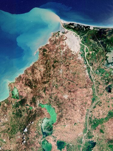
Barranquilla, the capital of the Atlántico department in northwest Colombia, is featured in this image taken by the Copernicus Sentinel-2 mission.
Nová verze aplikace Holixa T4R pro Revit
1.4.2022 9:52 Arkance SystemsUvádíme novou verzi aplikace Holixa T4R pro Revit, dříve známé pod názvem Tools for Revit nebo Revit Tools.
Zpráva Nová verze aplikace Holixa T4R pro Revit pochází z arkance-systems.cz.
20220401 - Nový speciální VFR s ÚÚP - dobývacími prostory
1.4.2022 9:40 ČÚZK /ruian/Novinky-RUIAN/Archiv-novinek-RUIAN/2022/20220401-Novy-specialni-VFR-s-UUP-dobyvacimi-pAgEagle to Host Fourth Quarter and Full Year 2021 Corporate Update on Tuesday, April 12, 2022 at 4:30 PM ET
1.4.2022 9:00 GISCafe.com Webcasts-Webinars WICHITA, Kan., March 31, 2022 (GLOBE NEWSWIRE) -- AgEagle Aerial Systems Inc. (NYSE American: UAVS) (“AgEagle” or the …20220401 - Nový speciální VFR s ÚÚP - dobývacími prostory
1.4.2022 8:26 ČÚZK /ruian/Poskytovani-udaju-ISUI-RUIAN-VDP/Vymenny-format-RUIAN-(VFR)/Archiv-novinek-VFR/2022/20220401-Novy-specialni-VFR-s-UUP-dobyvacimi-pAutel Robotics Drones Win Best of the Best of Red Dot Design Awards 2022
1.4.2022 2:33 GISCafe.com Webcasts-Webinars News Highlightsâ— Autel wins Red Dot awards
â— EVO Lite+ and EVO Nano+ drones named Best of the …
Trans-Atlantic team to develop technical concept for NATO’s Future Surveillance and Control capabilities
1.4.2022 2:29 GISCafe.com Webcasts-Webinars #NATO #ASPAARO @AirbusDefence @NorthropGrummanMunich / Falls Church, Va, 31 March 2022 – Airbus Defence and Space together with Northrop …
Planet Reports Financial Results for Fourth Quarter and Full Year of Fiscal 2022
1.4.2022 1:45 GISCafe.com Webcasts-Webinars Delivers Record Fourth Quarter Revenue of $37.1 Million and Full Year Revenue of $131.2 MillionExpands YoY Fourth Quarter GAAP Gross Margin from …
Intermap Files 2021 Annual Results
1.4.2022 1:45 GISCafe.com Webcasts-Webinars DENVER, March 31, 2022 — (PRNewswire) — Intermap Technologies (TSX: IMP) (OTCQX: ITMSF) ("Intermap" or the "Company"), a global leader …UltraMatch, the new revolutionary photogrammetry processing and LiDAR Geo-referencing software
31.3.2022 16:44 GISCafe.com Webcasts-Webinars March 31, 2022 -- MetaSpatial Solutions Pty Ltd., an Australian Geospatial Technology company, announced today the release of new cutting-edge …TomTom Partners with MIH Consortium
31.3.2022 16:20 GISCafe.com Webcasts-Webinars AMSTERDAM, March 31, 2022 (GLOBE NEWSWIRE) -- TomTom (TOM2), the geolocation technology specialist, today announced that it has joined the MIH …Kratos Demonstrates All-Digital Multi-Mission Edge Capability at the 37th Space Symposium
31.3.2022 16:20 GISCafe.com Webcasts-Webinars SAN DIEGO, March 31, 2022 (GLOBE NEWSWIRE) -- Kratos Defense & Security Solutions, Inc. (Nasdaq: KTOS), a leading National Security Solutions …Dvacátý Agrihub INSPIRE Hackathon 2022 v dubnu a květnu
31.3.2022 16:02 GeoBusinessAgriHub INSPIRE Hackathon je dvacátý ročník INSPIRE Hackathonu, který organizuje Plan4All, letos v rámci projektu AgriHub CZ&SK financovaného z projektu SmartAgriHubs H2020. Vychází z tradičního modelu INSPIRE Hackathonu, což znamená, že se nejedná o jednorázovou akci, ale o proces zaměřený na efektivní využití výsledků předchozích hackathonů zaměřených na vývoj nových inovací. V rámci tohoto hackathonu […]
The post Dvacátý Agrihub INSPIRE Hackathon 2022 v dubnu a květnu appeared first on GeoBusiness.
rada/odborný rada - rozhodování o povolení vkladu v právním oddělení Katastrálního pracoviště České
31.3.2022 14:01 ČÚZK - předpisy a opatření Katastrální úřad pro Jihočeský kraj Katastrální pracoviště České Budějovicevypisuje výběrové řízení na místo
rada/odborný rada - rozhodování o povolení vkladu v právním oddělení Katastrálního pracoviště České Budějovice (ID SM 30000095/30003719)
Chráněno: DTM ČR - největší geomatický projekt posledních let
31.3.2022 13:29 T-MAPYStručný obsah příspěvku zde není uveden, protože je tento příspěvek chráněn heslem.
The post Chráněno: DTM ČR - největší geomatický projekt posledních let appeared first on T-MAPY spol. s r.o..