


![]()

zprávy
zdroje zpráv:Přeshraniční editace verze 0.6
11.4.2022 17:23 ČÚZK - předpisy a opatření Do záložky Podklady IS DTM byl přidán dokument Přeshraniční editace: doplnění podrobného popisu pro implementaci systémuFrom CAD to Digital Twins Bentley Systems Visualizes Future of Infrastructure
11.4.2022 16:27 Bentley SystemsVelikonoční sleva na produkty společnosti AGACAD
11.4.2022 14:54 Arkance SystemsKaždá druhá licence software AGACAD za poloviční cenu až do 22. května. Nepropásněte výhodnou akci.
Zpráva Velikonoční sleva na produkty společnosti AGACAD pochází z arkance-systems.cz.
Online Public Portal Development Services Announced by Inspect2go
11.4.2022 13:27 GISCafe.com Webcasts-Webinars SAN CLEMENTE, Calif., April 11, 2022 — (PRNewswire) —Inspect2go's online portal enables the public to interact with state and local …
Locus Technologies Celebrates 25 Years of Innovative EHS & ESG Software
11.4.2022 13:27 GISCafe.com Webcasts-Webinars MOUNTAIN VIEW, Calif., April 11, 2022 (GLOBE NEWSWIRE) -- Locus Technologies, the leading EHS Compliance and ESG software provider, today …Allvision's New Offering Provides Customizable Access to Geospatial AI Platform
11.4.2022 13:27 GISCafe.com Webcasts-Webinars PITTSBURGH, April 11, 2022 — (PRNewswire) — Allvision IO, a geospatial analytics company, is pleased to announce the release of AIGIS …vrchní referent/rada - obnova katastrálního operátu v oddělení obnovy katastrálního operátu (3040) K
11.4.2022 12:06 ČÚZK - volná místa Katastrální úřad pro Jihočeský kraj odbor obnovy katastrálního operátu vypisuje výběrové řízení na místo vrchní referent/rada - obnova katastrálního operátu v oddělení obnovy katastrálního operátu (3040) Kvrchní referent/rada - obnova katastrálního operátu v oddělení obnovy katastrálního operátu (3040) K
11.4.2022 12:06 ČÚZK - předpisy a opatření Katastrální úřad pro Jihočeský kraj odbor obnovy katastrálního operátuvypisuje výběrové řízení na místo
vrchní referent/rada - obnova katastrálního operátu v oddělení obnovy katastrálního operátu (3040) Katastrálního úřadu pro Jihočeský kraj
vrchní referent/rada - obnova katastrálního operátu v oddělení obnovy katastrálního operátu (3040) K
11.4.2022 12:06 ČÚZK /Urady/Katastralni-urady/Katastralni-urady/Katastralni-urad-pro-Jihocesky-kraj/Uredni-deska/Oznameni-a-jina-uredni-sdeleni/Volna-mista/DMS/vrchni-referent-rada-obnova-katastralniho-oper-(1)SatLab Shone in GeoSmart India 2021
11.4.2022 12:03 Satlab Geosolutions During the 7th-9th of December 2021, the GeoSmart India 2021 was successfully held in Hyderabad, India.SatLab Shone in GeoSmart India 2021
11.4.2022 12:03 Satlab GeosolutionsDuring the 7th-9th of December 2021, the GeoSmart India 2021 was successfully held in Hyderabad, India.
The post SatLab Shone in GeoSmart India 2021 appeared first on Global Satellite Positioning Solutions | SatLab Geosolutions AB.
SatLab Shone in GeoSmart India 2021
11.4.2022 12:03 Satlab GeosolutionsDuring the 7th-9th of December 2021, the GeoSmart India 2021 was successfully held in Hyderabad, India.
The post SatLab Shone in GeoSmart India 2021 appeared first on Global Satellite Positioning Singapore | SatLab Geosolutions AB.
SatLab Shone in GeoSmart India 2021
11.4.2022 12:03 Satlab Geosolutions During the 7th-9th of December 2021, the GeoSmart India 2021 was successfully held in Hyderabad, India.Sdělení pro veřejnost
11.4.2022 10:52 ČÚZK /Urady/Katastralni-urady/Katastralni-urady/Katastralni-urad-pro-Ustecky-kraj/Katastralni-pracoviste/KP-Decin/O-uradu/Aktuality/Sdeleni-pro-verejnostSdělení pro veřejnost
11.4.2022 10:52 ČÚZK - předpisy a opatření Katastrální úřad pro Ústecký kraj - Katastrální pracoviště Děčín zveřejnil novou aktualitu: Vážení klienti,Dne 28. dubna 2022 bude podle oznámení ČEZ přerušena dodávka elektrické energie do budovy Katastrálního pracoviště Děčín. Přerušení potrvá od ranních do časných odpoledních hodin. Katastrální pracoviště tak nebude schopné poskytovat své služby. Proto bude Katastrální pracoviště Děčín dne 28.4.2022 pro veřejnost uzavřeno.
Za případné komplikace spojené s tímto mimořádným omezením provozu se omlouváme a děkujeme za pochopení.
Ing. Ivo Apfelbeck
ředitel katastrálního pracoviště
Nové sestavení GEUS 26.0.3.342
11.4.2022 9:16 GEUSware Bylo publikováno nové sestavení GEUS 26.0.3.342. Toto sestavení obsahuje podporu VFK verze 6.0 (změna kódování na UTF-8), které ČÚZK zavádí po 14.4.2022.Dwindling water levels of Lake Powell seen from space
11.4.2022 9:10 ESA Observing the Earth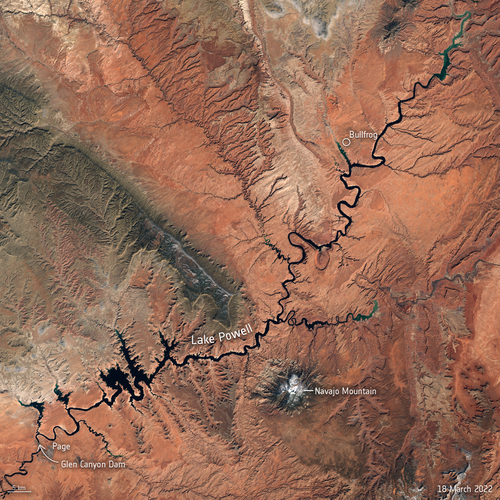
After decades of drought, water levels in Lake Powell, the second-largest humanmade reservoir in the United States, have shrunk to its lowest level since it was created more than 50 years ago, threatening millions of people who rely on its water supply. Satellite images allow us to take a closer look at the dwindling water levels of the lake amidst the climate crisis.
Přerušení provozu DP a WSDP ve dnech 14.4. - 18.4.2022
11.4.2022 9:09 GEUSware Upozorňujeme naše uživatele, že ČÚZK od čtvrtka 14.4.2022 od 14:30 do pondělí 18.4.2022 do cca 18 hodin bude z provozních důvodů zcela přerušen provoz Dálkového přístupu i Webových služeb dálkového přístupu. Z tohoto důvodu budou v GEUSu nefunkční Podklady měření a Odesílání GP. Přerušení provozu DP a WSDP ve dnech 14.4. - 18.4.2022
11.4.2022 9:09 GEUSware Upozorňujeme naše uživatele, že od čtvrtka 14.4.2022 od 14:30 do pondělí 18.4.2022 do cca 18 hodin bude z provozních důvodů zcela přerušen provoz Dálkového přístupu i Webových služeb dálkového přístupu. Z tohoto důvodu budou v GEUSu nefunkční Podklady měření a Odesílání GP. Úprava Databáze bodových polí
11.4.2022 9:00 ČÚZK - Geoportál Úprava Databáze bodových políGeodetické údaje nivelačních bodů podrobného výškového bodového pole z území hlavního města Prahy, které byly dosud dostupné pouze v analogové formě, byly doplněny do Databáze bodových polí a jsou tak nově dostupné na Geoportálu ČÚZK v rámci aplikace Geoprohlížeč produkt Bodová pole. Současně jsou tyto body dostupné v rámci Prohlížecí služby WMS Bodová pole i Stahovací služby WFS - Bodová pole.
Úprava Databáze bodových polí
11.4.2022 9:00 ČÚZK - Geoportál Úprava Databáze bodových políGeodetické údaje nivelačních bodů podrobného výškového bodového pole z území hlavního města Prahy, které byly dosud dostupné pouze v analogové formě, byly doplněny do Databáze bodových polí a jsou tak nově dostupné na Geoportálu ČÚZK v rámci aplikace Geoprohlížeč produkt Bodová pole. Současně jsou tyto body dostupné v rámci Prohlížecí služby WMS Bodová pole i Stahovací služby WFS - Bodová pole.
Štatistická ročenka za rok 2021
11.4.2022 8:51
ÚGKK SR
ÚGKK SR zverejnil na svojej stránke štatistickú ročenku za rok 2021. Ročenka je súborným materiálom poskytujúcim ucelený prehľad o vývoji pôdneho fondu a evidencií stavieb a bytov v Slovenskej republike. Okrem rozboru prírastkov a úbytkov poľnohospodárskej pôdy a lesných pozemkov obsahuje štatistická ročenka za rok 2021 s podrobnosťou okresov úhrnné hodnoty druhov pozemkov, počty parciel, stavieb a bytov a prehľad o plochách druhov pozemkov vo vlastníctve fyzických a právnických osôb podľa sumarizačného kódu k 1.1.2022. V prípade ďalších podrobností je možné napísať na info@skgeodesy.sk
Štatistická ročenka za rok 2021
11.4.2022 8:51 ÚGKK SRÚGKK SR zverejnil na svojej stránke štatistickú ročenku za rok 2021. Ročenka je súborným materiálom poskytujúcim ucelený prehľad o vývoji pôdneho fondu a evidencií stavieb a bytov v Slovenskej republike. Okrem rozboru prírastkov a úbytkov poľnohospodárskej pôdy a lesných pozemkov obsahuje štatistická ročenka za rok 2021 s podrobnosťou okresov úhrnné hodnoty druhov pozemkov, počty parciel, stavieb a bytov a prehľad o plochách druhov pozemkov vo vlastníctve fyzických a právnických osôb podľa sumarizačného kódu k 1.1.2022. V prípade ďalších podrobností je možné napísať na info@skgeodesy.sk
Štatistická ročenka za rok 2021
11.4.2022 8:51
ÚGKK SR
ÚGKK SR zverejnil na svojej stránke štatistickú ročenku za rok 2021. Ročenka je súborným materiálom poskytujúcim ucelený prehľad o vývoji pôdneho fondu a evidencií stavieb a bytov v Slovenskej republike. Okrem rozboru prírastkov a úbytkov poľnohospodárskej pôdy a lesných pozemkov obsahuje štatistická ročenka za rok 2021 s podrobnosťou okresov úhrnné hodnoty druhov pozemkov, počty parciel, stavieb a bytov a prehľad o plochách druhov pozemkov vo vlastníctve fyzických a právnických osôb podľa sumarizačného kódu k 1.1.2022. V prípade ďalších podrobností je možné napísať na info@skgeodesy.sk
Den s CAD/PDM expertem – bezplatná konzultace pro vaši firmu
11.4.2022 8:00 Arkance Systems27. dubna 2022 - využijte nové akce společnosti Arkance Systems a přihlaste se!
Zpráva Den s CAD/PDM expertem – bezplatná konzultace pro vaši firmu pochází z arkance-systems.cz.
Nabídka pracovní pozice
11.4.2022 7:31 Katedra geoinformatiky UP OlomoucZajímavá pracovní nabídka práce v oblasti precizního zemědělství Kariéra
The post Nabídka pracovní pozice appeared first on Katedra geoinformatiky.
Změna otevírací doby knihovny [Knihovna geografie, byTopic]
11.4.2022 0:00 Katedra aplikované geoinformatiky a kartografie Přf UK Z provozních důvodů bude Knihovna geografie otevřena v úterý 12.4.2022 pouze do 16,00. Děkujeme za pochopení.SPODEK 2022
10.4.2022 14:55 Katedra geoinformatiky UP OlomoucPo několikaleté odmlce je opět v plánu uspořádat Sportovní den katedry (Spodek). Proběhne 19.05.2022 od 8 hodin na adrese Tererovo náměstí 1, jedná se o venkovní sportovní hřiště základní školy. Připravujeme 5+1 nejen sportovních aktivit, můžete se těšit na fotbal, plážový volejbal a běh, další aktivity promýšlíme (skok do písku, přetahování lanem…). Soutěžit […]
The post SPODEK 2022 appeared first on Katedra geoinformatiky.
Mezinárodní den Měsíce
10.4.2022 12:34 Česká kosmická kancelář
Valné shromáždění OSN přijalo v prosinci loňského roku rezoluci, kterou se vyhlašuje datum 20. července Mezinárodním dnem Měsíce. Na tento den připadá výročí prvního přistání člověka na Měsíci, které v roce 1969 uskutečnila posádka americké kosmické mise Apollo 11.
Mezinárodní den Měsíce
10.4.2022 12:34 Česká kosmická kancelářValné shromáždění OSN přijalo v prosinci loňského roku rezoluci, kterou se vyhlašuje datum 20. července Mezinárodním dnem Měsíce. Na tento den připadá výročí prvního přistání člověka na Měsíci, které v roce 1969 uskutečnila posádka americké kosmické mise Apollo 11.
Mezinárodní den Měsíce
10.4.2022 12:34 Česká kosmická kancelář
Valné shromáždění OSN přijalo v prosinci loňského roku rezoluci, kterou se vyhlašuje datum 20. července Mezinárodním dnem Měsíce. Na tento den připadá výročí prvního přistání člověka na Měsíci, které v roce 1969 uskutečnila posádka americké kosmické mise Apollo 11.
CzBIM organizuje turnaj v minikopané Open BIM Cup 2022
9.4.2022 10:11 BIM News Odborná rada pro BIM zve všechny architekty, stavební inženýry, projektanty, statiky, konstruktéry, stavbyvedoucí, stavební firmy, dodavatele, výrobce, investory, developery, geodety na Open BIM Cup 2022. Přihlaste do turnaje svůj až 10členný fotbalový tým Zvolte druh účasti (podpory) na turnaji, základní startovné je 10 000 Kč za tým Pak už stačí jen nazout turfy a ukázat, […]CzBIM organizuje turnaj v minikopané Open BIM Cup 2022
9.4.2022 10:11 BIM NewsOdborná rada pro BIM zve všechny architekty, stavební inženýry, projektanty, statiky, konstruktéry, stavbyvedoucí, stavební firmy, dodavatele, výrobce, investory, developery, geodety na Open BIM Cup 2022. Přihlaste do turnaje svůj až 10členný fotbalový tým Zvolte druh účasti (podpory) na turnaji, základní startovné je 10 000 Kč za tým Pak už stačí jen nazout turfy a ukázat, […]
The post CzBIM organizuje turnaj v minikopané Open BIM Cup 2022 appeared first on BIM News.
CzBIM organizuje turnaj v minikopané. Open BIM Cup 2022
9.4.2022 10:11 BIM NewsOdborná rada pro BIM zve všechny architekty, stavební inženýry, projektanty, statiky, konstruktéry, stavbyvedoucí, stavební firmy, dodavatele, výrobce, investory, developery, geodety na Open BIM Cup 2022. Přihlaste do turnaje svůj až 10členný fotbalový tým Zvolte druh účasti (podpory) na turnaji, základní startovné je 10 000 Kč za tým Pak už stačí jen nazout turfy a ukázat, […]
The post CzBIM organizuje turnaj v minikopané. Open BIM Cup 2022 appeared first on BIM News.
Prezentácia predsedu ÚGKK SR na Valnom zhromaždení Komory geodetov a kartografov 08.04.2022
8.4.2022 20:00
ÚGKK SR
Prierezové informácie z rezortu ÚGKK SR od minuloročného valného zhromaždenia KGK doteraz.
Realizované aktivity v tomto období a plánované aktivity v nasledujúcich rokoch.
„ Prezentácia predsedu ÚGKK SR na Valnom zhromaždení Komory geodetov a kartografov 08.04.2022
8.4.2022 20:00
ÚGKK SR
Prierezové informácie z rezortu ÚGKK SR od minuloročného valného zhromaždenia KGK doteraz.
Realizované aktivity v tomto období a plánované aktivity v nasledujúcich rokoch.
„ Prezentácia predsedu ÚGKK SR na Valnom zhromaždení Komory geodetov a kartografov 08.04.2022
8.4.2022 20:00
ÚGKK SR
Prierezové informácie z rezortu ÚGKK SR od minuloročného valného zhromaždenia KGK doteraz.
Realizované aktivity v tomto období a plánované aktivity v nasledujúcich rokoch.
„ Prezentácia predsedu ÚGKK SR na Valnom zhromaždení Komory geodetov a kartografov 08.04.2022
8.4.2022 20:00 ÚGKK SRPrierezové informácie z rezortu ÚGKK SR od minuloročného valného zhromaždenia KGK doteraz.
Realizované aktivity v tomto období a plánované aktivity v nasledujúcich rokoch.
Trimble Opens Registration for its 2022 Insight Tech Conference + Expo
8.4.2022 16:19 GISCafe.com Webcasts-Webinars SUNNYVALE, Calif., April 8, 2022 — (PRNewswire) — Trimble (NASDAQ: TRMB) opened registration for its 2022 Insight Tech Conference + …DRONY PRO UKRAJINU – tisková zpráva
8.4.2022 14:49 Hrdlička Ke dni 31. 3. byla vydána tisková zpráv k projektu Drony pro Ukrajinu.Přerušení provozu DP a WSDP ve čtvrtek 14.4.2022 od 14:30 až do 18.4.2022 do cca 18:00.
8.4.2022 13:31 Dálkový přístup k údajům KN ČR Vážení uživatelé,oznamujeme, že ve čtvrtek 14.4.2022 od 14:30 bude z provozních důvodů zcela přerušen provoz Dálkového přístupu i Webových služeb dálkového přístupu. Obnovení provozu předpokládáme 18.4.2022 v cca 18 hodin. U této verze dochází ke změně XSD sestav webových služeb (https://www.cuzk.cz/Aplikace-DP-do-KN/Aplikace-DP-do-KN/Archiv-DP/351948.aspx?feed=RSS).
Za komplikace tímto způsobené se omlouváme a děkujeme za pochopení.
Přerušení provozu DP a WSDP ve čtvrtek 14.4.2022 od 14:30 až do 18.4.2022 do cca 18:00.
8.4.2022 13:31 ČÚZK - předpisy a opatření Vážení uživatelé,oznamujeme, že ve čtvrtek 14.4.2022 od 14:30 bude z provozních důvodů zcela přerušen provoz Dálkového přístupu i Webových služeb dálkového přístupu. Obnovení provozu předpokládáme 18.4.2022 v cca 18 hodin. U této verze dochází ke změně XSD sestav webových služeb (https://www.cuzk.cz/Aplikace-DP-do-KN/Aplikace-DP-do-KN/Archiv-DP/351948.aspx?feed=RSS).
Za komplikace tímto způsobené se omlouváme a děkujeme za pochopení.
Přerušení provozu DP a WSDP ve čtvrtek 14.4.2022 od 14:30 až do 18.4.2022 do cca 18:00.
8.4.2022 13:31 ČÚZK /Aplikace-DP-do-KN/Aplikace-DP-do-KN/Archiv-DP/352556DTM ČR - největší geomatický projekt posledních let
8.4.2022 13:20 T-MAPYThe post DTM ČR - největší geomatický projekt posledních let appeared first on T-MAPY spol. s r.o..
DTM ČR - největší geomatický projekt posledních let
8.4.2022 13:20 T-MAPYThe post DTM ČR - největší geomatický projekt posledních let appeared first on T-MAPY spol. s r.o..
How the EU Space Programme helps address the new challenges of a changing Arctic
8.4.2022 12:51 European GNSS Agency
Polar regions are faced with emerging challenges. Climate change is affecting the entire globe, but it is especially pronounced at the poles. With an integrated EU Space Programme in place, Europe has the capacity to better understand the challenges the Arctic Circle is confronted with, shape new mitigating policies and develop the necessary tools to fight climate change.
With nearly half the country sitting north of the Arctic Circle, Norway has a front row seat to the unprecedented changes taking place in this polar region. Climate change is causing temperatures in the Arctic Circle to rise twice as fast as anywhere else on the planet. As the ice melts, the Arctic Ocean is opening and shipping companies are moving in. According to the Arctic Council, ship traffic in the area grew by 25% between 2013 and 2019.
It was also in this context that EUSPA Executive Director, Rodrigo da Costa, delivered a keynote speech at the Oslo Position Conference 2022. His visit to the Norwegian capital was a great opportunity to confer with Jan Christian Vestre Minister of Trade, Industry and Fisheries, on the huge potential of EU Space across 17 markets. Global Navigation Satellite System (GNSS) & Earth Observation (EO) revenues are expected to reach 500 billion by 2031. Besides, Norway has been supporting European innovation with several H2020 funded projects such as Prepare Ships. Da Costa also met with Norwegian Space Agency leadership and members of the Norwegian Parliament’s Standing Committee on Business and Industry to give an overview of how the Arctic stands to benefit from the EU Space Programme.
“Increased maritime traffic in this remote polar region, in combination with more unpredictable and extreme weather events, raises many new challenges”, said EUSPA Executive Director Rodrigo da Costa. “In the event of a ship running aground or a collision, search and rescue crews have to navigate rough seas, freezing temperatures and vast spaces in order to evacuate the vessel and provide emergency services.”
This is where Galileo comes into play.
Galileo supports search and rescue operations Galileo, Europe’s GNSS, provides improved positioning and timing information to a range of users – including search and rescue (SAR) teams.
Galileo’s SAR service contributes to life-saving efforts by swiftly relaying radio beacon distress signals to the relevant SAR crews by means of dedicated payloads onboard Galileo satellites, supported by three ground stations strategically deployed across Europe. But what really sets the Galileo SAR service apart is its unique Return Link Service (RLS) – a feature that allows people in distress to receive an automatic acknowledgement that their signal has been picked up by emergency first responders.
The Galileo SAR service is fully integrated into the Cospas-Sarsat system, a non-profit satellite-based search and rescue distress alert detection and information distribution system. The SAR transponder on the Galileo satellites picks up signals emitted from distress beacons in the 406 – 406.1 MHz band. It then broadcasts this information to dedicated ground stations called MEOLUTS, which use the signals to generate an independent location of the beacon. This location is then relayed to first responders through dedicated Cospas-Sarsat Mission Control Centres.
In Case You Missed It: EUSPA celebrates ‘406Day’.
Because it offers greater coverage in higher latitudes and thus a more robust performance, Galileo brings particularly important added value to Arctic SAR operations – value which was on full display during a large-scale rescue exercise that took place in the Artic Circle last year. Following the activation of the onboard distress signal, the Galileo SAR service was able to track the ship’s location in just 2 minutes and 20 seconds and with an accuracy of under one kilometre.
Safe navigation, environmental protection and mitigating climate change
But Galileo isn’t the only EU Space Programme benefiting the Arctic. The Copernicus Earth Observation programme’s Marine service provides ship captains and search and rescue teams with essential data on wave height and direction and the presence of sea ice, for example. And ships of all sizes rely on the accurate positioning provided by Galileo to safely navigate across these remote waters.
Furthermore, as the Arctic sees more ship traffic, the risk of environmental catastrophes, such as oil spills, increases. Here, Copernicus satellites can provide optical and synthetic aperture radar images which, combined with accurate positioning from Galileo, allow authorities to quickly reach the spill site, understand the extent of the risk, and implement necessary actions.
The EU Space Programme also plays an important role in mitigating how climate change impacts the Nordic environment. On the one hand, the accurate navigation offered by Galileo and EGNOS can optimise shipping routes to reduce greenhouse gas emissions and fuel consumption. On the other hand, the Copernicus Marine and Climate Change Services monitor a number of key climate indicators, such as sea level, temperature, currents and salinity. This data can then be used to drive global climate policy decisions.
Read More: The world has a water problem, and space may have a solution
All the benefits that the EU Space Programme brings to the Arctic region are highlighted in a short film produced by EUSPA, which was premiered for the Norwegian Space Agency. “Protecting the Arctic and its many ecosystems are an important component of the EU Green Deal,” said da Costa while introducing the film. “Through an integrated EU Space Programme and by working closely with our partners in the Arctic like NOSA, we are better-positioned to understand the challenges, find solutions and implement change.”
Media note: This feature can be republished without charge provided the European Union Agency for the Space Programme (EUSPA) is acknowledged as the source at the top or the bottom of the story. You must request permission before you use any of the photographs on the site. If you republish, we would be grateful if you could link back to the EUSPA website (http://www.euspa.europa.eu).
How the EU Space Programme helps address the new challenges of a changing Arctic
8.4.2022 12:51 European GNSS AgencyPolar regions are faced with emerging challenges. Climate change is affecting the entire globe, but it is especially pronounced at the poles. With an integrated EU Space Programme in place, Europe has the capacity to better understand the challenges the Arctic Circle is confronted with, shape new mitigating policies and develop the necessary tools to fight climate change.
With nearly half the country sitting north of the Arctic Circle, Norway has a front row seat to the unprecedented changes taking place in this polar region. Climate change is causing temperatures in the Arctic Circle to rise twice as fast as anywhere else on the planet. As the ice melts, the Arctic Ocean is opening and shipping companies are moving in. According to the Arctic Council, ship traffic in the area grew by 25% between 2013 and 2019.
It was also in this context that EUSPA Executive Director, Rodrigo da Costa, delivered a keynote speech at the Oslo Position Conference 2022. His visit to the Norwegian capital was a great opportunity to confer with Jan Christian Vestre Minister of Trade, Industry and Fisheries, on the huge potential of EU Space across 17 markets. Global Navigation Satellite System (GNSS) & Earth Observation (EO) revenues are expected to reach 500 billion by 2031. Besides, Norway has been supporting European innovation with several H2020 funded projects such as Prepare Ships. Da Costa also met with Norwegian Space Agency leadership and members of the Norwegian Parliament’s Standing Committee on Business and Industry to give an overview of how the Arctic stands to benefit from the EU Space Programme.
“Increased maritime traffic in this remote polar region, in combination with more unpredictable and extreme weather events, raises many new challenges”, said EUSPA Executive Director Rodrigo da Costa. “In the event of a ship running aground or a collision, search and rescue crews have to navigate rough seas, freezing temperatures and vast spaces in order to evacuate the vessel and provide emergency services.”
This is where Galileo comes into play.
Galileo supports search and rescue operations Galileo, Europe’s GNSS, provides improved positioning and timing information to a range of users – including search and rescue (SAR) teams.
Galileo’s SAR service contributes to life-saving efforts by swiftly relaying radio beacon distress signals to the relevant SAR crews by means of dedicated payloads onboard Galileo satellites, supported by three ground stations strategically deployed across Europe. But what really sets the Galileo SAR service apart is its unique Return Link Service (RLS) – a feature that allows people in distress to receive an automatic acknowledgement that their signal has been picked up by emergency first responders.
The Galileo SAR service is fully integrated into the Cospas-Sarsat system, a non-profit satellite-based search and rescue distress alert detection and information distribution system. The SAR transponder on the Galileo satellites picks up signals emitted from distress beacons in the 406 – 406.1 MHz band. It then broadcasts this information to dedicated ground stations called MEOLUTS, which use the signals to generate an independent location of the beacon. This location is then relayed to first responders through dedicated Cospas-Sarsat Mission Control Centres.
In Case You Missed It: EUSPA celebrates ‘406Day’.
Because it offers greater coverage in higher latitudes and thus a more robust performance, Galileo brings particularly important added value to Arctic SAR operations – value which was on full display during a large-scale rescue exercise that took place in the Artic Circle last year. Following the activation of the onboard distress signal, the Galileo SAR service was able to track the ship’s location in just 2 minutes and 20 seconds and with an accuracy of under one kilometre.
Safe navigation, environmental protection and mitigating climate change
But Galileo isn’t the only EU Space Programme benefiting the Arctic. The Copernicus Earth Observation programme’s Marine service provides ship captains and search and rescue teams with essential data on wave height and direction and the presence of sea ice, for example. And ships of all sizes rely on the accurate positioning provided by Galileo to safely navigate across these remote waters.
Furthermore, as the Arctic sees more ship traffic, the risk of environmental catastrophes, such as oil spills, increases. Here, Copernicus satellites can provide optical and synthetic aperture radar images which, combined with accurate positioning from Galileo, allow authorities to quickly reach the spill site, understand the extent of the risk, and implement necessary actions.
The EU Space Programme also plays an important role in mitigating how climate change impacts the Nordic environment. On the one hand, the accurate navigation offered by Galileo and EGNOS can optimise shipping routes to reduce greenhouse gas emissions and fuel consumption. On the other hand, the Copernicus Marine and Climate Change Services monitor a number of key climate indicators, such as sea level, temperature, currents and salinity. This data can then be used to drive global climate policy decisions.
Read More: The world has a water problem, and space may have a solution
All the benefits that the EU Space Programme brings to the Arctic region are highlighted in a short film produced by EUSPA, which was premiered for the Norwegian Space Agency. “Protecting the Arctic and its many ecosystems are an important component of the EU Green Deal,” said da Costa while introducing the film. “Through an integrated EU Space Programme and by working closely with our partners in the Arctic like NOSA, we are better-positioned to understand the challenges, find solutions and implement change.” Insertion of video for now
Media note: This feature can be republished without charge provided the European Union Agency for the Space Programme (EUSPA) is acknowledged as the source at the top or the bottom of the story. You must request permission before you use any of the photographs on the site. If you republish, we would be grateful if you could link back to the EUSPA website (http://www.euspa.europa.eu).
How the EU Space Programme helps address the new challenges of a changing Arctic
8.4.2022 12:51 European GNSS Agency
Polar regions are faced with emerging challenges. Climate change is affecting the entire globe, but it is especially pronounced at the poles. With an integrated EU Space Programme in place, Europe has the capacity to better understand the challenges the Arctic Circle is confronted with, shape new mitigating policies and develop the necessary tools to fight climate change.
With nearly half the country sitting north of the Arctic Circle, Norway has a front row seat to the unprecedented changes taking place in this polar region. Climate change is causing temperatures in the Arctic Circle to rise twice as fast as anywhere else on the planet. As the ice melts, the Arctic Ocean is opening and shipping companies are moving in. According to the Arctic Council, ship traffic in the area grew by 25% between 2013 and 2019.
It was also in this context that EUSPA Executive Director, Rodrigo da Costa, delivered a keynote speech at the Oslo Position Conference 2022. His visit to the Norwegian capital was a great opportunity to confer with Jan Christian Vestre Minister of Trade, Industry and Fisheries, on the huge potential of EU Space across 17 markets. Global Navigation Satellite System (GNSS) & Earth Observation (EO) revenues are expected to reach 500 billion by 2031. Besides, Norway has been supporting European innovation with several H2020 funded projects such as Prepare Ships. Da Costa also met with Norwegian Space Agency leadership and members of the Norwegian Parliament’s Standing Committee on Business and Industry to give an overview of how the Arctic stands to benefit from the EU Space Programme.
“Increased maritime traffic in this remote polar region, in combination with more unpredictable and extreme weather events, raises many new challenges”, said EUSPA Executive Director Rodrigo da Costa. “In the event of a ship running aground or a collision, search and rescue crews have to navigate rough seas, freezing temperatures and vast spaces in order to evacuate the vessel and provide emergency services.”
This is where Galileo comes into play.
Galileo supports search and rescue operations Galileo, Europe’s GNSS, provides improved positioning and timing information to a range of users – including search and rescue (SAR) teams.
Galileo’s SAR service contributes to life-saving efforts by swiftly relaying radio beacon distress signals to the relevant SAR crews by means of dedicated payloads onboard Galileo satellites, supported by three ground stations strategically deployed across Europe. But what really sets the Galileo SAR service apart is its unique Return Link Service (RLS) – a feature that allows people in distress to receive an automatic acknowledgement that their signal has been picked up by emergency first responders.
The Galileo SAR service is fully integrated into the Cospas-Sarsat system, a non-profit satellite-based search and rescue distress alert detection and information distribution system. The SAR transponder on the Galileo satellites picks up signals emitted from distress beacons in the 406 – 406.1 MHz band. It then broadcasts this information to dedicated ground stations called MEOLUTS, which use the signals to generate an independent location of the beacon. This location is then relayed to first responders through dedicated Cospas-Sarsat Mission Control Centres.
In Case You Missed It: EUSPA celebrates ‘406Day’.
Because it offers greater coverage in higher latitudes and thus a more robust performance, Galileo brings particularly important added value to Arctic SAR operations – value which was on full display during a large-scale rescue exercise that took place in the Artic Circle last year. Following the activation of the onboard distress signal, the Galileo SAR service was able to track the ship’s location in just 2 minutes and 20 seconds and with an accuracy of under one kilometre.
Safe navigation, environmental protection and mitigating climate change
But Galileo isn’t the only EU Space Programme benefiting the Arctic. The Copernicus Earth Observation programme’s Marine service provides ship captains and search and rescue teams with essential data on wave height and direction and the presence of sea ice, for example. And ships of all sizes rely on the accurate positioning provided by Galileo to safely navigate across these remote waters.
Furthermore, as the Arctic sees more ship traffic, the risk of environmental catastrophes, such as oil spills, increases. Here, Copernicus satellites can provide optical and synthetic aperture radar images which, combined with accurate positioning from Galileo, allow authorities to quickly reach the spill site, understand the extent of the risk, and implement necessary actions.
The EU Space Programme also plays an important role in mitigating how climate change impacts the Nordic environment. On the one hand, the accurate navigation offered by Galileo and EGNOS can optimise shipping routes to reduce greenhouse gas emissions and fuel consumption. On the other hand, the Copernicus Marine and Climate Change Services monitor a number of key climate indicators, such as sea level, temperature, currents and salinity. This data can then be used to drive global climate policy decisions.
Read More: The world has a water problem, and space may have a solution
All the benefits that the EU Space Programme brings to the Arctic region are highlighted in a short film produced by EUSPA, which was premiered for the Norwegian Space Agency. “Protecting the Arctic and its many ecosystems are an important component of the EU Green Deal,” said da Costa while introducing the film. “Through an integrated EU Space Programme and by working closely with our partners in the Arctic like NOSA, we are better-positioned to understand the challenges, find solutions and implement change.”
Media note: This feature can be republished without charge provided the European Union Agency for the Space Programme (EUSPA) is acknowledged as the source at the top or the bottom of the story. You must request permission before you use any of the photographs on the site. If you republish, we would be grateful if you could link back to the EUSPA website (http://www.euspa.europa.eu).
Mapa silniční sítě 2022
8.4.2022 12:23 Jihočeský krajV sekci Ke stažení je k dispozici aktualizovaná mapa silniční sítě k 1.1.2022 v měřítku 1 : 100 000 za Jihočeský kraj.
Mapa administrativního členění 2022
8.4.2022 12:23 Jihočeský krajV sekci Ke stažení je k dispozici aktualizovaná mapa administrativního členění k 1.1.2022 v rozměru mapy A1 za Jihočeský kraj.
Zveřejnění obsahu informací poskytnutých na žádost dle zákona č. 106/1999 Sb. za rok 2022
8.4.2022 12:19 ČÚZK /Urady/Zememericke-a-katastralni-inspektoraty/Zememericke-a-katastralni-inspektoraty/Zememericky-a-katastralni-inspektorat-v-Praze/Casto-hledane-informace/Poskytovani-informaci-106-1999-Sb/Zverejneni-obsahu-informaci-poskytnutych-na-za-(1)/Zverejneni-obsahu-informaci-poskytnutych-na-za-(5)Zveřejnění obsahu informací poskytnutých na žádost dle zákona č. 106/1999 Sb. za rok 2022
8.4.2022 12:19 ČÚZK - předpisy a opatření Zeměměřický a katastrální inspektorát v Prazezveřejňuje obsah informace poskytnutých na žádost dle zákona č. 106/1999 Sb. za rok
2022
Nedostupné produkční prostředí ISÚI
8.4.2022 11:33 ČÚZK /ruian/Editacni-agendovy-system-ISUI/Provozni-informace-a-odstavky/Archiv-PROD/Nedostupne-produkcni-prostredi-ISUI-(32)Dnes podepsali ministři Ministerstva dopravy a Ministerstva obrany České republiky memorandum o spolupráci při užívání dronů
8.4.2022 10:46 UAVADnes podepsali ministři Ministerstvo dopravy a Ministerstvo obrany České republiky memorandum o spolupráci při užívání dronů, kde je uvedena důležitost vzniku testovacích prostorů (prvním by mělo být letiště v Přerově) a zavádění U-space. Prezident Aliance byl hostem vysílání ČT24 k tomuto tématu. Nyní je na řadě přijetí novely zákona o civilním letectví, která už čeká […]
The post Dnes podepsali ministři Ministerstva dopravy a Ministerstva obrany České republiky memorandum o spolupráci při užívání dronů appeared first on UAV Aliance pro bezpilotní letecký průmysl.
Earth from Space: Sindh, Pakistan
8.4.2022 10:00 ESA Observing the Earth
The Copernicus Sentinel-2 mission takes us over part of Sindh – the third-largest province of Pakistan.
Ride into orbit secured for Sentinel-1C
8.4.2022 9:00 ESA Observing the Earth
A contract signed with Arianespace secures the launch for the third Copernicus Sentinel-1 satellite. Scheduled to lift off on ESA’s new Vega-C rocket from Europe’s Spaceport in French Guiana in the first half of 2023, Sentinel-1C will continue the critical task of delivering key radar imagery for a wide range of services, applications and science – all of which benefit society.
Kleos successfully launches Patrol Mission satellites
8.4.2022 9:00 GISCafe.com Webcasts-Webinars Kleos Space S.A, (ASX: KSS, Frankfurt: KS1) a space-powered Radio Frequency Reconnaissance data-as-a-service (DaaS) company, successfully launched …Ride into orbit secured for Copernicus Sentinel-1C
8.4.2022 9:00 ESA Observing the Earth
A contract signed with Arianespace secures the launch for the third Copernicus Sentinel-1 satellite. Scheduled to lift off on ESA’s new Vega-C rocket from Europe’s Spaceport in French Guiana in the first half of 2023, Sentinel-1C will continue the critical task of delivering key radar imagery for a wide range of services, applications and science – all of which benefit society.
Woolpert Contracted by USGS to Conduct Geophysical Surveys Related to Critical Minerals, Energy Research, Hazard Assessments in Arkansas
8.4.2022 9:00 GISCafe.com Webcasts-Webinars Woolpert Contracted by USGS to Conduct Geophysical Surveys Related to Critical Minerals, Energy Research, Hazard Assessments in ArkansasThe firm …
Nové sestavení Geometr 19.0.07
8.4.2022 8:59 GEUSware Bylo publikováno nové sestavení Geometr 19.0.07, které obsahuje podporu VFK 6.0 (změna kódování na UTF-8). Dále umožňuje v tabulkách GP řadit stavební parcely před pozemkové.Nové sestavení Geometr 19.0.07
8.4.2022 8:59 GEUSware Bylo publikováno nové sestavení Geometr 19.0.07, které obsahuje podporu VFK 6.0 (změna kódování na UTF-8). Dále umožňuje v tabulkách GP řadit stavební parcely před pozemkové.Symboly obývacího nábytku firmy GWINNER – Německý interiér
8.4.2022 8:53 ŠPINAR - software Vážení zákazníci,dovolujeme si Vám nabídnout bezplatně nové knihovny nábytku pro obývací pokoje GWINNER pro TurboCAD Platinum 27 a DAEX DESIGN 22.
Symboly obývacího nábytku firmy GWINNER – Německý interiér
8.4.2022 8:53 ŠPINAR - softwareVážení zákazníci,
dovolujeme si Vám nabídnout bezplatně nové knihovny nábytku pro obývací pokoje GWINNER pro TurboCAD Platinum 27 a DAEX DESIGN 22.
The post Symboly obývacího nábytku firmy GWINNER – Německý interiér appeared first on ŠPINAR – software.
Kniha Kartografie pro nekartografy zdarma ke stažení
8.4.2022 8:21 GISportal.cz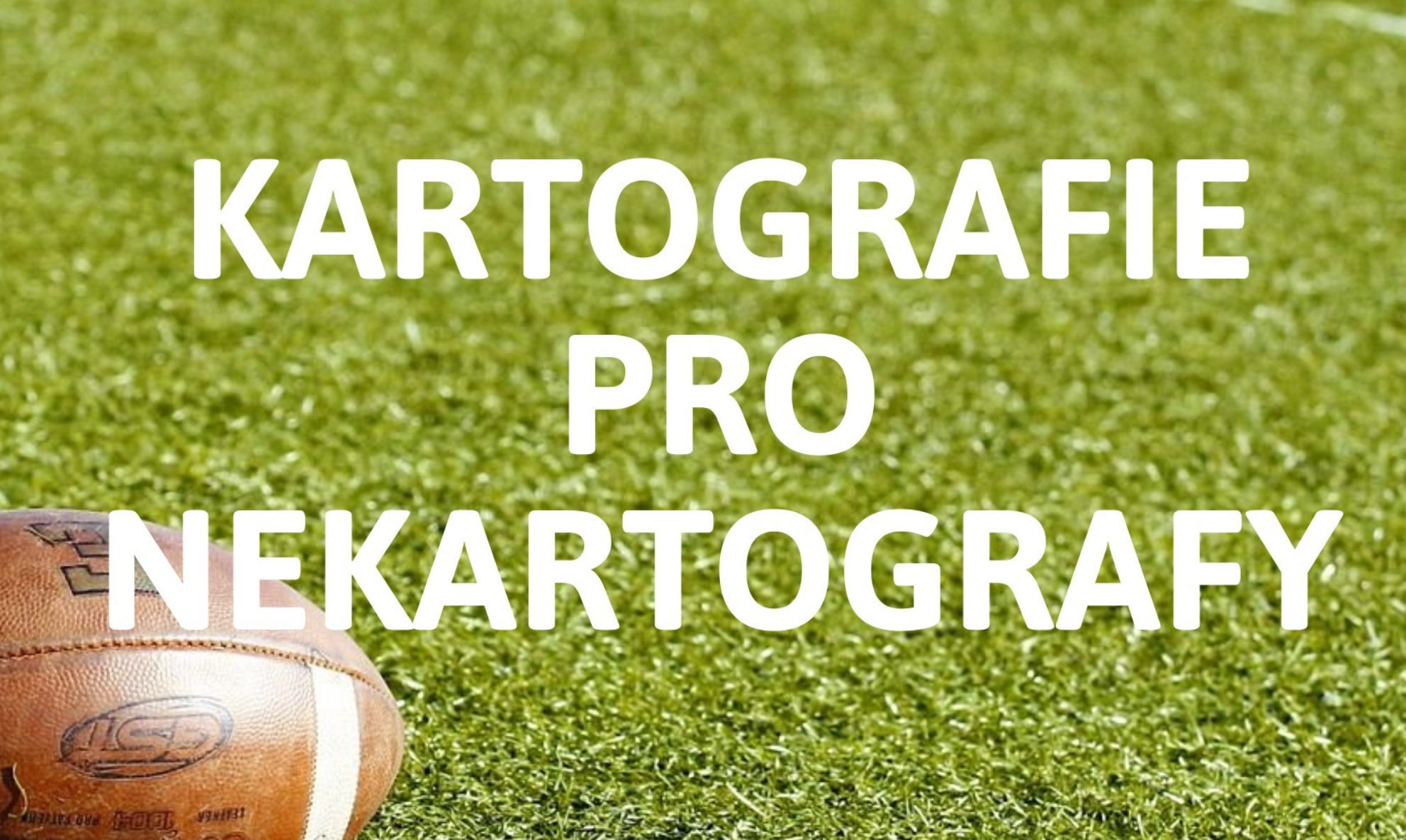
Doc. Otakar Čerba z katedry geomatiky Západočeské univerzity v Plzni vydal učebnici kartografie pro nekartografy, která, nezvykle pro dnešní dobu, je volně ke stažení v různých formátech (stačí vyplnit jméno a email). Kniha poutavě, jednoduše a vtipně na příkladu amerického fotbalu (neplést si s ragby či evropským fotbalem (v angličtině soccer)) prezentuje základy kartografické tvorby […]
The post Kniha Kartografie pro nekartografy zdarma ke stažení appeared first on GISportal.cz.
Záznam webináře APG o letecké fotogrammetrii
8.4.2022 8:11 ZeměměřičAsociace podnikatelů v geomatice uspořádala 21. března webinář, zaměřený na leteckou fotogrammetrii. Tato metoda hromadného sběru dat je totiž zajímavá v souvislosti s připravovanou Digitální technickou mapou ČR, kdy bude potřeba v krátkém časovém období mít a udržovat geodata pro celé území. Se svým referátem vystoupili Jiří Šíma, Petr Dušánek (Zeměměřický úřad), Karel Vondráček (Georeal), Zdeněk Klusoň (Primis) a Jakub Karas (UpVision). […]
The post Záznam webináře APG o letecké fotogrammetrii appeared first on Zeměměřič.
Prodej automobilu Octavia v aukci na ÚZSVM
8.4.2022 7:55 ČÚZK - předpisy a opatřeníKatastrální úřad pro Liberecký kraj Prodej automobilu Octavia v aukci na ÚZSVM
Prodej automobilu Octavia v aukci na ÚZSVM
Prodej automobilu Octavia v aukci na ÚZSVM
8.4.2022 7:55 ČÚZK /Urady/Katastralni-urady/Katastralni-urady/Katastralni-urad-pro-Liberecky-kraj/Nabidky-majetku/Prodej-automobilu-Octavia-v-aukci-na-UZSVM-(1)Prodej automobilu Fabia v aukci na ÚZSVM
8.4.2022 7:52 ČÚZK /Urady/Katastralni-urady/Katastralni-urady/Katastralni-urad-pro-Liberecky-kraj/Nabidky-majetku/Prodej-automobilu-Fabia-v-aukci-na-UZSVM-(1)Prodej automobilu Fabia v aukci na ÚZSVM
8.4.2022 7:52 ČÚZK - předpisy a opatřeníKatastrální úřad pro Liberecký kraj Prodej automobilu Fabia v aukci na ÚZSVM
Prodej automobilu Fabia v aukci na ÚZSVM
Bentley Systems Announces Acquisition of ADINA to Extend Nonlinear Simulation throughout Infrastructure Engineering
8.4.2022 1:52 GISCafe.com Webcasts-Webinars Digital Twins Will Benefit from Authoritative ADINA Simulations for Enhanced Infrastructure ResilienceEXTON, Pa. — (BUSINESS WIRE) — …

Bentley Systems Announces Acquisition of ADINA to Extend Nonlinear Simulation
7.4.2022 20:40 Bentley SystemsPress Announcements
Percepto drones receive approval to fly BVLOS under new European regulation
7.4.2022 16:37 GISCafe.com Webcasts-Webinars MODI'IN, Israel, April 7, 2022 — (PRNewswire) — Percepto, pioneering autonomous inspection by industrial robotics, today announced …Rozpočet úřadu za rok 2022
7.4.2022 13:51 ČÚZK /Urady/Zememericky-urad/Rozpocty/Rozpocet-uradu-za-rok-2022Rozpočet úřadu za rok 2022
7.4.2022 13:51 ČÚZK - předpisy a opatření Zeměměřický úřadvystavuje rozpočet úřadu za rok
2022
Rozpočet úřadu za rok 2022
7.4.2022 13:51 Zeměměřický úřad Zeměměřický úřadvystavuje rozpočet úřadu za rok
2022
Living Planet Fellowship: Call for Proposals
7.4.2022 13:11 ESA Observing the EarthLiving Planet Fellowship: Call for Proposals
Hexagon selected by Anchorage Police Department for next-gen 9-1-1 solution
7.4.2022 12:00 Hexagon Safety & InfrastructureInterview with Paul Braun, Senior Vice President, Axim Geospatial
7.4.2022 9:00 GISCafe.com Webcasts-WebinarsKrátká dubnová sleva 15 % na nejoblíbenější produkty Autodesku
7.4.2022 0:00 Arkance SystemsNabídka produktů AutoCAD, AutoCAD LT a AutoCAD Revit LT Suite se slevou. Akce trvá pouze do 12.4. 2022.
Zpráva Krátká dubnová sleva 15 % na nejoblíbenější produkty Autodesku pochází z arkance-systems.cz.
Michael Baker International Introduces Consulting and Technology Solutions Vertical
6.4.2022 21:20 GISCafe.com Webcasts-Webinars PITTSBURGH, April 6, 2022 — (PRNewswire) — Michael Baker International, a global leader in engineering, planning and consulting …vHive Raises $25 Million in Series B Led by PSG
6.4.2022 20:26 GISCafe.com Webcasts-Webinars Funding to support vHive's vision to digitize enterprise assets and expand operations globallyNEW YORK and LONDON, April 5, 2022 — …
Referent/ka ZKN
6.4.2022 15:32 Zeměměřický úřad Zeměměřický úřadvypisuje výběrové řízení na místo
Referent/ka ZKN
Referent/ka ZKN
6.4.2022 15:32 ČÚZK - předpisy a opatření Zeměměřický úřadvypisuje výběrové řízení na místo
Referent/ka ZKN
Referent/ka ZKN
6.4.2022 15:32 ČÚZK - volná místa Zeměměřický úřad vypisuje výběrové řízení na místo Referent/ka ZKNRozpočet úřadu za rok 2022
6.4.2022 15:30 ČÚZK /Urady/Katastralni-urady/Katastralni-urady/Katastralni-urad-pro-Zlinsky-kraj/Rozpocet/Rozpocet-uradu-za-rok-2022Rozpočet úřadu za rok 2022
6.4.2022 15:30 ČÚZK - předpisy a opatření Katastrální úřad pro Zlínský krajvystavuje rozpočet úřadu za rok
2022
Výroční zpráva dle zákona č. 106/1999 Sb. za rok 2022
6.4.2022 15:03 ČÚZK - předpisy a opatření Katastrální úřad pro Ústecký krajvydává výroční zprávu úřadu za rok 2022
2022
Výroční zpráva dle zákona č. 106/1999 Sb. za rok 2022
6.4.2022 15:03 ČÚZK /Urady/Katastralni-urady/Katastralni-urady/Katastralni-urad-pro-Ustecky-kraj/Vyrocni-zpravy/Vyrocni-zprava-dle-zakona-c-106-1999-Sb-za-rok-(5)Mapová aplikace ÚPD - nové dokumentace
6.4.2022 12:53 Jihočeský krajV mapové aplikaci Územně plánovací dokumentace obcí byla aktualizována ÚPD obcí ORP Jindřichův Hradec – Blažejov, ORP Kaplice – Kaplice, Netřebice, ORP Vimperk – Buk.
EUSPA celebrates “406Day”, the International Search and Rescue Beacon Day by lifting the veil on new life-saving features.
6.4.2022 12:40 European GNSS Agency
Beacon Awareness Day (#406Day) is an opportunity to celebrate the amazing work carried out by Search and Rescue teams across the globe that risk their lives daily to save people in distress. It also aims to remind the owners of Search and Rescue beacons of the need to register their beacons and test them regularly.
On #406Day2021, we celebrate Search and Rescue teams all around the world. But why 406? Well, 406 Day, as April 6th is written in the US where the initiative emerged, is a reference to the 406 MHz frequency of the Search and Rescue beacons used by the international rescue organisation Cospas-Sarsat. These beacons help save an average of seven lives every day around the world.
The EU Agency for the Space Programme (EUSPA), the European Commission, and their partners, the European Space Agency (ESA), is proud to celebrate Galileo’s contribution to this international effort.
The Search and Rescue (SAR) transponders installed onboard the Galileo satellites decrease the detection and location time of a distress beacon dramatically, speeding up the rescue response and augmenting the chances of survival. Galileo/SAR is the only system delivering the Return Link Service (RLS). This feature provides the user in distress with an acknowledgment indication on the beacon that the distress signal was received and its position located.
Today, Galileo provides more than 90% of the approved L-band satellite-based search and rescue capabilities with 24/7 worldwide coverage. On top, Galileo is also the largest search and rescue ground segment provider with a committed performance of over 20% of the Earth's surface.
It is a great European achievement, which shows that Europe is not only a major space power but also an actor continuously working on people's well-being. The 406 Day is also the perfect occasion to pay tribute to all the members of the Rescue teams around the world.
As announced last year, and based on the feedback received from more than 250 operational Search and Rescue units, Galileo is designing new features to answer their operational needs as closely as possible, to save even more lives. The Remote Beacon Activation Service (e.g. in the case of the disappearance of a plane or a vessel) and the Two-Way communication functionality (that allows rescue coordinators to send pre-programmed questions and instructions to the person in distress) is due to enter into preliminary testing shortly.
Media note: This feature can be republished without charge provided the European Union Agency for the Space Programme (EUSPA) is acknowledged as the source at the top or the bottom of the story. You must request permission before you use any of the photographs on the site. If you republish, we would be grateful if you could link back to the EUSPA website (http://www.euspa.europa.eu).
EUSPA celebrates “406Day”, the International Search and Rescue Beacon Day by lifting the veil on new life-saving features.
6.4.2022 12:40 European GNSS AgencyBeacon Awareness Day (#406Day) is an opportunity to celebrate the amazing work carried out by Search and Rescue teams across the globe that risk their lives daily to save people in distress. It also aims to remind the owners of Search and Rescue beacons of the need to register their beacons and test them regularly.
On #406Day2021, we celebrate Search and Rescue teams all around the world. But why 406? Well, 406 Day, as April 6th is written in the US where the initiative emerged, is a reference to the 406 MHz frequency of the Search and Rescue beacons used by the international rescue organisation Cospas-Sarsat. These beacons help save an average of seven lives every day around the world.
The EU Agency for the Space Programme (EUSPA), the European Commission, and their partners, the European Space Agency (ESA), is proud to celebrate Galileo’s contribution to this international effort.
The Search and Rescue (SAR) transponders installed onboard the Galileo satellites decrease the detection and location time of a distress beacon dramatically, speeding up the rescue response and augmenting the chances of survival. Galileo/SAR is the only system delivering the Return Link Service (RLS). This feature provides the user in distress with an acknowledgment indication on the beacon that the distress signal was received and its position located.
Today, Galileo provides more than 90% of the approved L-band satellite-based search and rescue capabilities with 24/7 worldwide coverage. On top, Galileo is also the largest search and rescue ground segment provider with a committed performance of over 20% of the Earth's surface.
It is a great European achievement, which shows that Europe is not only a major space power but also an actor continuously working on people's well-being. The 406 Day is also the perfect occasion to pay tribute to all the members of the Rescue teams around the world.
As announced last year, and based on the feedback received from more than 250 operational Search and Rescue units, Galileo is designing new features to answer their operational needs as closely as possible, to save even more lives. The Remote Beacon Activation Service (e.g. in the case of the disappearance of a plane or a vessel) and the Two-Way communication functionality (that allows rescue coordinators to send pre-programmed questions and instructions to the person in distress) is due to enter into preliminary testing shortly.
See how EU Space mitigates risks and saves lives in the Arctic region.
Media note: This feature can be republished without charge provided the European Union Agency for the Space Programme (EUSPA) is acknowledged as the source at the top or the bottom of the story. You must request permission before you use any of the photographs on the site. If you republish, we would be grateful if you could link back to the EUSPA website (http://www.euspa.europa.eu).
EUSPA celebrates “406Day”, the International Search and Rescue Beacon Day by lifting the veil on new life-saving features.
6.4.2022 12:40 European GNSS AgencyBeacon Awareness Day (#406Day) is an opportunity to celebrate the amazing work carried out by Search and Rescue teams across the globe that risk their lives daily to save people in distress. It also aims to remind the owners of Search and Rescue beacons of the need to register their beacons and test them regularly.
On #406Day2021, we celebrate Search and Rescue teams all around the world. But why 406? Well, 406 Day, as April 6th is written in the US where the initiative emerged, is a reference to the 406 MHz frequency of the Search and Rescue beacons used by the international rescue organisation Cospas-Sarsat. These beacons help save an average of seven lives every day around the world.
The EU Agency for the Space Programme (EUSPA), the European Commission, and their partners, the European Space Agency (ESA), is proud to celebrate Galileo’s contribution to this international effort.
The Search and Rescue (SAR) transponders installed onboard the Galileo satellites decrease the detection and location time of a distress beacon dramatically, speeding up the rescue response and augmenting the chances of survival. Galileo/SAR is the only system delivering the Return Link Service (RLS). This feature provides the user in distress with an acknowledgment indication on the beacon that the distress signal was received and its position located.
Today, Galileo provides more than 90% of the approved L-band satellite-based search and rescue capabilities with 24/7 worldwide coverage. On top, Galileo is also the largest search and rescue ground segment provider with a committed performance of over 20% of the Earth's surface.
It is a great European achievement, which shows that Europe is not only a major space power but also an actor continuously working on people's well-being. The 406 Day is also the perfect occasion to pay tribute to all the members of the Rescue teams around the world.
As announced last year, and based on the feedback received from more than 250 operational Search and Rescue units, Galileo is designing new features to answer their operational needs as closely as possible, to save even more lives. The Remote Beacon Activation Service (e.g. in the case of the disappearance of a plane or a vessel) and the Two-Way communication functionality (that allows rescue coordinators to send pre-programmed questions and instructions to the person in distress) is due to enter into preliminary testing shortly.
Watch our first ever short documentary to see how Galileo-enabled Emergency Position-Indicating Radiobeacon (EPIRB) is used to save lives in the Arctic Circle, and what benefits the EU Space Programme brings to better understand and fight the challenges climate change is causing, from affecting communities and ecosystems to disrupting maritime operations in the Arctic Circle.
Media note: This feature can be republished without charge provided the European Union Agency for the Space Programme (EUSPA) is acknowledged as the source at the top or the bottom of the story. You must request permission before you use any of the photographs on the site. If you republish, we would be grateful if you could link back to the EUSPA website (http://www.euspa.europa.eu).
EUSPA celebrates “406Day”, the International Search and Rescue Beacon Day by lifting the veil on new life-saving features.
6.4.2022 12:40 European GNSS AgencyBeacon Awareness Day (#406Day) is an opportunity to celebrate the amazing work carried out by Search and Rescue teams across the globe that risk their lives daily to save people in distress. It also aims to remind the owners of Search and Rescue beacons of the need to register their beacons and test them regularly.
On #406Day2021, we celebrate Search and Rescue teams all around the world. But why 406? Well, 406 Day, as April 6th is written in the US where the initiative emerged, is a reference to the 406 MHz frequency of the Search and Rescue beacons used by the international rescue organisation Cospas-Sarsat. These beacons help save an average of seven lives every day around the world.
The EU Agency for the Space Programme (EUSPA), the European Commission, and their partners, the European Space Agency (ESA), is proud to celebrate Galileo’s contribution to this international effort.
The Search and Rescue (SAR) transponders installed onboard the Galileo satellites decrease the detection and location time of a distress beacon dramatically, speeding up the rescue response and augmenting the chances of survival. Galileo/SAR is the only system delivering the Return Link Service (RLS). This feature provides the user in distress with an acknowledgment indication on the beacon that the distress signal was received and its position located.
Today, Galileo provides more than 90% of the approved L-band satellite-based search and rescue capabilities with 24/7 worldwide coverage. On top, Galileo is also the largest search and rescue ground segment provider with a committed performance of over 20% of the Earth's surface.
It is a great European achievement, which shows that Europe is not only a major space power but also an actor continuously working on people's well-being. The 406 Day is also the perfect occasion to pay tribute to all the members of the Rescue teams around the world.
As announced last year, and based on the feedback received from more than 250 operational Search and Rescue units, Galileo is designing new features to answer their operational needs as closely as possible, to save even more lives. The Remote Beacon Activation Service (e.g. in the case of the disappearance of a plane or a vessel) and the Two-Way communication functionality (that allows rescue coordinators to send pre-programmed questions and instructions to the person in distress) is due to enter into preliminary testing shortly.
Media note: This feature can be republished without charge provided the European Union Agency for the Space Programme (EUSPA) is acknowledged as the source at the top or the bottom of the story. You must request permission before you use any of the photographs on the site. If you republish, we would be grateful if you could link back to the EUSPA website (http://www.euspa.europa.eu).