


![]()

zprávy
zdroje zpráv:Odstávka aplikací, mapových a vyhledávacích služeb Geoportálu ČÚZK
6.12.2021 10:00 ČÚZK - Geoportál Odstávka aplikací, mapových a vyhledávacích služeb Geoportálu ČÚZKDne 8.12. 2021 po 21 hodině dojde k plánované odstávce a nebudou proto dostupné funkce aplikací Geoprohlížeč, Archiv, Analýzy výškopisu. Dále nebudou dostupné mapové a vyhledávací služby publikované na URL http://ags.cuzk.cz/arcgis.
Předpokládaná doba odstávky 4 hodiny. Omlouváme se za případné komplikace.
Odstávka aplikací, mapových a vyhledávacích služeb Geoportálu ČÚZK
6.12.2021 10:00 ČÚZK - Geoportál Odstávka aplikací, mapových a vyhledávacích služeb Geoportálu ČÚZKDne 8.12. 2021 po 21 hodině dojde k plánované odstávce a nebudou proto dostupné funkce aplikací Geoprohlížeč, Archiv, Analýzy výškopisu. Dále nebudou dostupné mapové a vyhledávací služby publikované na URL http://ags.cuzk.cz/arcgis.
Předpokládaná doba odstávky 4 hodiny. Omlouváme se za případné komplikace.
SatLab Products Exhibition in GeoSmart India 2021
6.12.2021 9:37 Satlab GeosolutionsEvent: GeoSmart India 2021 | SatLab Products Exhibition Date: 7th-9th December 2021 GeoSmart India 2021 is going to be held physically from 7th-9th, December in Hyderabad, India. More than 800 delegates from the global geospatial community will attend this annual prestigious geospatial event. The theme of GeoSmart 2021 is ADVANCING THE ROLE OF GEOSPATIAL KNOWLEDGE IN […]
The post SatLab Products Exhibition in GeoSmart India 2021 appeared first on SatLab – Global Satellite Positioning Solutions.
Nedostupnost WSDP na zkoušku ve dnech 6.12. - 10.12.2021
6.12.2021 8:13 ČÚZK /Aplikace-DP-do-KN/Aplikace-DP-do-KN/Archiv-DP/340750Nedostupnost WSDP na zkoušku ve dnech 6.12. - 10.12.2021
6.12.2021 8:13 Dálkový přístup k údajům KN ČR Vážení uživatelé webových služeb,oznamujeme, že z technických důvodů budou ve dnech od 6.12.2021 do 10.12.2021 nedostupné webové služby dálkového přístupu na zkoušku.
Za komplikace se omlouváme a děkujeme za pochopení.
Nedostupnost WSDP na zkoušku ve dnech 6.12. - 10.12.2021
6.12.2021 8:13 ČÚZK - předpisy a opatření Vážení uživatelé webových služeb,oznamujeme, že z technických důvodů budou ve dnech od 6.12.2021 do 10.12.2021 nedostupné webové služby dálkového přístupu na zkoušku.
Za komplikace se omlouváme a děkujeme za pochopení.
Prezentace Knihovny geografie na konferenci Archivy, knihovny, muzea v digitálním světě 2021 [Knihovna geografie, byTopic]
6.12.2021 0:00 Katedra aplikované geoinformatiky a kartografie Přf UK Již 22. ročník konference, kterou uspořádaly Svaz knihovníků a informačních pracovníků ČR, Národní knihovna ČR a Česká informační společnost, proběhl 30. listopadu až 1. prosince 2021 v online formátu. Knihovnu geografie zastoupila Michaela Alijonov Hametová s příspěvkem Citování (nejen digitálních) kartografických dokumentů.dMY Technology Group, Inc. IV Stockholders Approve Proposed Business Combination with Planet
5.12.2021 16:42 GISCafe.com Webcasts-Webinars Transaction Expected to Close on December 7, 2021SAN FRANCISCO — (BUSINESS WIRE) — December 3, 2021 —
Planet Labs Inc. …
Two new satellites mark further enlargement of Galileo
5.12.2021 6:59 ESA Navigation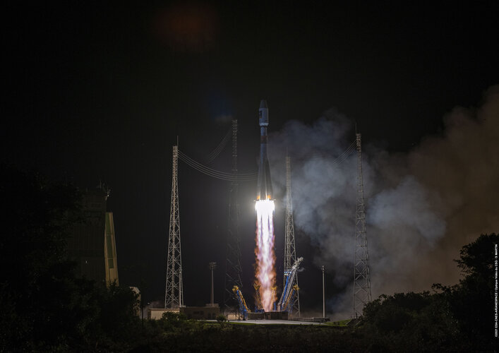
Europe’s largest satellite constellation has grown even bigger, following the launch of two more Galileo navigation satellites by Soyuz launcher from Europe’s Spaceport in French Guiana on 5 December. Galileo satellites 27-28 add to an existing 26-satellite constellation in orbit, providing the world’s most precise satnav positioning to more than 2.3 billion users around the globe.
Watch Galileo launch on night of 4-5 December
4.12.2021 1:34 ESA Navigation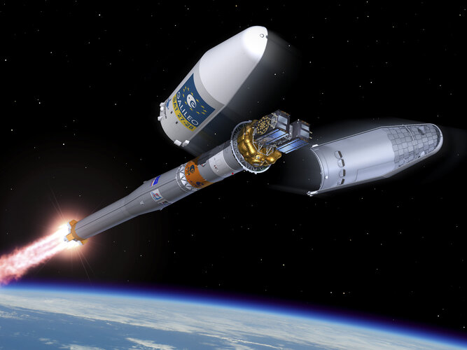
Galileo satellites 27 – 28 lifted off by Soyuz launcher VS26 from Europe’s Spaceport in French Guiana at 01:19 CET on 5 December (4 December at 21:19 local Kourou time). Follow the launch live on ESA Web TV Two.
Galileo launch postponed
4.12.2021 1:34 ESA Navigation
The launch of Europe’s latest Galileo satellites has been postponed. Launch operations were interrupted at H-10 minutes due to adverse weather conditions (lightning). The Soyuz launch vehicle and satellites are in a stable and safe condition.
Watch Galileo launch on night of 4-5 December
4.12.2021 1:34 ESA Navigation
The launch of Europe’s latest Galileo satellites is now scheduled for the night of 4-5 December.
Airbus completes second ocean satellite Sentinel-6B
4.12.2021 1:04 GISCafe.com Webcasts-Webinars Sentinel-6B loaded in Container in Friedrichshafen / Sentinel-6B en transfert à Friedrichshafen / Sentinel-6B wird in Friedrichshafen …Přerušení provozu DP a WSDP v pátek 10.12.2021 od 14:30 do cca 19:00. Přerušení provozu Sbírky listi
3.12.2021 21:18 ČÚZK - předpisy a opatření Vážení uživatelé,oznamujeme, že v pátek 10.12.2021 bude od 14:30 z provozních důvodů zcela přerušen provoz Dálkového přístupu i Webových služeb dálkového přístupu. Obnovení provozu předpokládáme do cca 19 hodin, s výjimkou poskytování dokumentů ze Sbírky listin – to by mělo být dostupné od soboty 11.12.2021 od cca 12:00.
Za komplikace tímto způsobené se omlouváme a děkujeme za pochopení.
Přerušení provozu DP a WSDP v pátek 10.12.2021 od 14:30 do cca 19:00. Přerušení provozu Sbírky listi
3.12.2021 21:18 ČÚZK /Aplikace-DP-do-KN/Aplikace-DP-do-KN/Archiv-DP/340734Přerušení provozu DP a WSDP v pátek 10.12.2021 od 14:30 do cca 19:00. Přerušení provozu Sbírky listi
3.12.2021 21:18 Dálkový přístup k údajům KN ČR Vážení uživatelé,oznamujeme, že v pátek 10.12.2021 bude od 14:30 z provozních důvodů zcela přerušen provoz Dálkového přístupu i Webových služeb dálkového přístupu. Obnovení provozu předpokládáme do cca 19 hodin, s výjimkou poskytování dokumentů ze Sbírky listin – to by mělo být dostupné od soboty 11.12.2021 od cca 12:00.
Za komplikace tímto způsobené se omlouváme a děkujeme za pochopení.
After the successful launch of 2 new Galileo satellites, the satellites operations are now ongoing.
3.12.2021 18:11 European GNSS Agency
The Galileo satellites 27 and 28 were successfully launched on-board of a Soyuz carrier earlier on December 4 at 21:19, Kourou time – or on December 5 at 01:19 CET from Europe’s Spaceport in French Guyana.
Earlier today, the 46m tall Soyuz launcher VS-26, successfully lifted off from Kourou, French Guyana, for a nearly four-hour voyage till the separation of the Galileo satellites 27-28 from the rocket. The Galileo Launch 11 is the first of a series of 6 launches (with two satellites per launch), which will allow Galileo to deliver greater accuracy to existing users and open up new market opportunities.
The Galileo satellites were ejected from the upper stage of the launcher at 05:09 CET. They are currently managed from the Galileo Control Centre in Oberpfaffenhofen in Germany by the EU Agency for the Space Programme (EUSPA) and its Galileo Service Operator team led by SpaceOpal, in charge of the satellite operations after separation from the Launch vehicle. It is part of the Launch and Early Orbit Phase (LEOP)
The Launch and Early Orbit Phase is one of the most exciting and important phases of a space mission, as it handles the launch of the spacecraft its travel into the correct orbit, gradually switching on the spacecraft platform to test the core-satellite elements. Over the following days, the EUSPA and SpaceOpal team will be manoeuvring the satellites until the start of the drift phase which should last around 3 weeks till the Drift Stop and Fine Positioning Manoeuvres (DSFP), when the satellites will be placed into their home orbit at 23 220 km.
Upon commissioning and rigorous in-Orbit tests, the spacecraft will enter into the Galileo service provision.
“Today we can proudly celebrate another milestone achieved by the European Union’s most ambitious and largest industrial project, Galileo’’ says EUSPA Executive Director, Rodrigo da Costa. “The successful addition of satellites 27-28 to the world’s most precise positioning system is a very important step for our more than 2 billion users around the world and is the result of a robust collaboration between us, the European Commission, the European Space Agency (ESA), and our industrial partners. I would like to express my deepest gratitude to all the parties involved, who are working relentlessly to ensure the success of the mission.”
Watch Rodrigo da Costa message here.
Media note: This feature can be republished without charge provided the European Union Agency for the Space Programme (EUSPA) is acknowledged as the source at the top or the bottom of the story. You must request permission before you use any of the photographs on the site. If you republish, we would be grateful if you could link back to the EUSPA website (http://www.euspa.europa.eu).
After the successful launch of 2 new Galileo satellites, the satellites operations are now ongoing.
3.12.2021 18:11 European GNSS AgencyThe Galileo satellites 27 and 28 were successfully launched on-board of a Soyuz carrier earlier on December 4 at 21:19, Kourou time – or on December 5 at 01:19 CET from Europe’s Spaceport in French Guyana.
Earlier today, the 46m tall Soyuz launcher VS-26, successfully lifted off from Kourou, French Guyana, for a nearly four-hour voyage till the separation of the Galileo satellites 27-28 from the rocket. The Galileo Launch 11 is the first of a series of 6 launches (with two satellites per launch), which will allow Galileo to deliver greater accuracy to existing users and open up new market opportunities.
The Galileo satellites were ejected from the upper stage of the launcher at 05:09 CET. They are currently managed from the Galileo Control Centre in Oberpfaffenhofen in Germany by the EU Agency for the Space Programme (EUSPA) and its Galileo Service Operator team led by SpaceOpal, in charge of the satellite operations after separation from the Launch vehicle. It is part of the Launch and Early Orbit Phase (LEOP)
Relive the launch here
The Launch and Early Orbit Phase is one of the most exciting and important phases of a space mission, as it handles the launch of the spacecraft its travel into the correct orbit, gradually switching on the spacecraft platform to test the core-satellite elements. Over the following days, the EUSPA and SpaceOpal team will be manoeuvring the satellites until the start of the drift phase which should last around 3 weeks till the Drift Stop and Fine Positioning Manoeuvres (DSFP), when the satellites will be placed into their home orbit at 23 220 km.
Upon commissioning and rigorous in-Orbit tests, the spacecraft will enter into the Galileo service provision.
“Today we can proudly celebrate another milestone achieved by the European Union’s most ambitious and largest industrial project, Galileo’’ says EUSPA Executive Director, Rodrigo da Costa. “The successful addition of satellites 27-28 to the world’s most precise positioning system is a very important step for our more than 2 billion users around the world and is the result of a robust collaboration between us, the European Commission, the European Space Agency (ESA), and our industrial partners. I would like to express my deepest gratitude to all the parties involved, who are working relentlessly to ensure the success of the mission.”
Watch Rodrigo da Costa's message here.
Media note: This feature can be republished without charge provided the European Union Agency for the Space Programme (EUSPA) is acknowledged as the source at the top or the bottom of the story. You must request permission before you use any of the photographs on the site. If you republish, we would be grateful if you could link back to the EUSPA website (http://www.euspa.europa.eu).
After the successful launch of 2 new Galileo satellites, the satellites operations are now ongoing
3.12.2021 18:11 European GNSS AgencyThe Galileo satellites 27 and 28 were successfully launched on-board of a Soyuz carrier earlier on December 4 at 21:19, Kourou time – or on December 5 at 01:19 CET from Europe’s Spaceport in French Guyana.
Earlier today, the 46m tall Soyuz launcher VS-26, successfully lifted off from Kourou, French Guyana, for a nearly four-hour voyage till the separation of the Galileo satellites 27-28 from the rocket. The Galileo Launch 11 is the first of a series of 6 launches (with two satellites per launch), which will allow Galileo to deliver greater accuracy to existing users and open up new market opportunities.
The Galileo satellites were ejected from the upper stage of the launcher at 05:09 CET. They are currently managed from the Galileo Control Centre in Oberpfaffenhofen in Germany by the EU Agency for the Space Programme (EUSPA) and its Galileo Service Operator team led by SpaceOpal, in charge of the satellite operations after separation from the Launch vehicle. It is part of the Launch and Early Orbit Phase (LEOP)
Relive the launch here
The Launch and Early Orbit Phase is one of the most exciting and important phases of a space mission, as it handles the launch of the spacecraft its travel into the correct orbit, gradually switching on the spacecraft platform to test the core-satellite elements. Over the following days, the EUSPA and SpaceOpal team will be manoeuvring the satellites until the start of the drift phase which should last around 3 weeks till the Drift Stop and Fine Positioning Manoeuvres (DSFP), when the satellites will be placed into their home orbit at 23 220 km.
Upon commissioning and rigorous in-Orbit tests, the spacecraft will enter into the Galileo service provision.
“Today we can proudly celebrate another milestone achieved by the European Union’s most ambitious and largest industrial project, Galileo’’ says EUSPA Executive Director, Rodrigo da Costa. “The successful addition of satellites 27-28 to the world’s most precise positioning system is a very important step for our more than 2 billion users around the world and is the result of a robust collaboration between us, the European Commission, the European Space Agency (ESA), and our industrial partners. I would like to express my deepest gratitude to all the parties involved, who are working relentlessly to ensure the success of the mission.”
Watch Rodrigo da Costa's message here.
Media note: This feature can be republished without charge provided the European Union Agency for the Space Programme (EUSPA) is acknowledged as the source at the top or the bottom of the story. You must request permission before you use any of the photographs on the site. If you republish, we would be grateful if you could link back to the EUSPA website (http://www.euspa.europa.eu).
Ředitel/ka Katastrálního pracoviště Sokolov, Katastrální úřad pro Karlovarský kraj
3.12.2021 13:13 ČÚZK - volná místa Katastrální úřad pro Karlovarský kraj Katastrální pracoviště Sokolov vypisuje výběrové řízení na místo Ředitel/ka Katastrálního pracoviště Sokolov, Katastrální úřad pro Karlovarský krajŘeditel/ka Katastrálního pracoviště Sokolov, Katastrální úřad pro Karlovarský kraj
3.12.2021 13:13 ČÚZK - předpisy a opatření Katastrální úřad pro Karlovarský kraj Katastrální pracoviště Sokolovvypisuje výběrové řízení na místo
Ředitel/ka Katastrálního pracoviště Sokolov, Katastrální úřad pro Karlovarský kraj
Ředitel/ka Katastrálního pracoviště Sokolov, Katastrální úřad pro Karlovarský kraj
3.12.2021 13:13 ČÚZK /Urady/Katastralni-urady/Katastralni-urady/Katastralni-urad-pro-Karlovarsky-kraj/Uredni-deska/Oznameni-a-jina-uredni-sdeleni/Volna-mista/DMS/Reditel-ka-Katastralniho-pracoviste-Sokolov,-KatasOdborný referent / vrchní referent – zápisy v řízení V a Z v oddělení právních vztahů k nemovitostem
3.12.2021 12:25 ČÚZK - volná místa Katastrální úřad pro Zlínský kraj Katastrální pracoviště Zlín vypisuje výběrové řízení na místo Odborný referent / vrchní referent – zápisy v řízení V a Z v oddělení právních vztahů k nemovitostemOdborný referent / vrchní referent – zápisy v řízení V a Z v oddělení právních vztahů k nemovitostem
3.12.2021 12:25 ČÚZK - předpisy a opatření Katastrální úřad pro Zlínský kraj Katastrální pracoviště Zlínvypisuje výběrové řízení na místo
Odborný referent / vrchní referent – zápisy v řízení V a Z v oddělení právních vztahů k nemovitostem Katastrálního pracoviště Zlín
Rada / odborný rada – organizační pracovník kanceláře ředitele Katastrálního úřadu pro Zlínský kraj
3.12.2021 11:38 ČÚZK - volná místa Katastrální úřad pro Zlínský kraj vypisuje výběrové řízení na místo Rada / odborný rada – organizační pracovník kanceláře ředitele Katastrálního úřadu pro Zlínský krajRada / odborný rada – organizační pracovník kanceláře ředitele Katastrálního úřadu pro Zlínský kraj
3.12.2021 11:38 ČÚZK /Urady/Katastralni-urady/Katastralni-urady/Katastralni-urad-pro-Zlinsky-kraj/Uredni-deska/Oznameni-a-jina-uredni-sdeleni/Volna-mista/DMS/Rada-odborny-rada-–-organizacni-pracovnik-kancelRada / odborný rada – organizační pracovník kanceláře ředitele Katastrálního úřadu pro Zlínský kraj
3.12.2021 11:38 ČÚZK - předpisy a opatření Katastrální úřad pro Zlínský krajvypisuje výběrové řízení na místo
Rada / odborný rada – organizační pracovník kanceláře ředitele Katastrálního úřadu pro Zlínský kraj
Online ukázka: Příprava stahovací služby ATOM v metadatovém editoru Národního geoportálu INSPIRE
3.12.2021 11:01 CENIA - národní geoportál INSPIRE Vážení uživatelé Národní geoportálu INSPIRE, v rámci Dne s INSPIRE, který se uskutečnil 30. listopadu 2021, proběhla i online ukázka, jak připravit stahovací služby ATOM v metadatovém editoru Národního geoportálu INSPIRE. Videozáznam této přednášky si můžete pustit zde. Prezentaci si můžete stáhnout zde.Sdělení
3.12.2021 10:14 ČÚZK /Urady/Zememericke-a-katastralni-inspektoraty/Zememericke-a-katastralni-inspektoraty/Zememericky-a-katastralni-inspektorat-v-Praze/O-uradu/Aktuality/SdeleniSdělení
3.12.2021 10:14 ČÚZK - předpisy a opatření Zeměměřický a katastrální inspektorát v Praze zveřejnil novou aktualitu: S ohledem na epidemickou situaci žádáme klienty, aby přednostně využívali písemný, elektronický (e-mail, datová schránka) či telefonický kontakt.Děkujeme za pochopení.
20211206 - volné místo - Rada/odborný rada v OMaK kanc. ředitele katastrálního úřadu na KÚ pro ÚK
3.12.2021 10:14 ČÚZK /Urady/Katastralni-urady/Katastralni-urady/Katastralni-urad-pro-Ustecky-kraj/O-uradu/Aktuality/20211206-volne-misto-Rada-odborny-rada-v OMaK20211206 - volné místo - Rada/odborný rada v OMaK kanc. ředitele katastrálního úřadu na KÚ pro ÚK
3.12.2021 10:14 ČÚZK - předpisy a opatření Katastrální úřad pro Ústecký kraj zveřejnil novou aktualitu: Nabídka volného místa - Rada / odborný rada v oddělení metodiky a kontroly kanceláře ředitele katastrálního úřadu na Katastrálním úřadu pro Ústecký krajRada / odborný rada v oddělení metodiky a kontroly kanceláře ředitele katastrálního úřadu na Katastr
3.12.2021 10:11 ČÚZK - předpisy a opatření Katastrální úřad pro Ústecký kraj kancelář ředitelevypisuje výběrové řízení na místo
Rada / odborný rada v oddělení metodiky a kontroly kanceláře ředitele katastrálního úřadu na Katastrálním úřadu pro Ústecký kraj
Rada / odborný rada v oddělení metodiky a kontroly kanceláře ředitele katastrálního úřadu na Katastr
3.12.2021 10:11 ČÚZK /Urady/Katastralni-urady/Katastralni-urady/Katastralni-urad-pro-Ustecky-kraj/Uredni-deska/Oznameni-a-jina-uredni-sdeleni/Volna-mista/DMS/Rada-odborny-rada-v oddeleni-metodiky-a-kontrolyRada / odborný rada v oddělení metodiky a kontroly kanceláře ředitele katastrálního úřadu na Katastr
3.12.2021 10:11 ČÚZK - volná místa Katastrální úřad pro Ústecký kraj kancelář ředitele vypisuje výběrové řízení na místo Rada / odborný rada v oddělení metodiky a kontroly kanceláře ředitele katastrálního úřadu na KatastrEarth from Space: White Nile, Sudan
3.12.2021 10:00 ESA Observing the Earth
A part of the White Nile state in Sudan is featured in this false-colour image captured by the Copernicus Sentinel-2 mission.
Earth from Space: White Nile, Sudan
3.12.2021 10:00 ESA Observing the Earth
A part of the White Nile state in Sudan is featured in this false-colour image captured by the Copernicus Sentinel-2 mission.
Tech Leaders Partner with TomTom to Transform the Digital Cockpit Experience through TomTom IndiGO
3.12.2021 9:00 GISCafe.com Webcasts-Webinars AMSTERDAM, Nov. 30, 2021 (GLOBE NEWSWIRE) -- TomTom (TOM2), the geolocation technology specialist, today announced that industry leading companies …Successful Rocket Lab Launch Strengthens BlackSky Constellation by Two Satellites
3.12.2021 9:00 GISCafe.com Webcasts-Webinars Satellites enter revenue generation six days after launchHERNDON, Va. — (BUSINESS WIRE) — November 30, 2021 — “This was the …
Interview with Chris Mewse, Managing Director, Geoxphere
3.12.2021 9:00 GISCafe.com Webcasts-WebinarsLuxCarta Announces 3D Building & Tree Extraction for BrightEarth at IITSEC
3.12.2021 9:00 GISCafe.com Webcasts-Webinars Real-time Extraction from Sub-meter ImagerySophia Antipolis, France – November 29, 2021 – LuxCarta introduced its newest …
Planet To Present at the Morgan Stanley Space Summit on December 7, 2021
3.12.2021 9:00 GISCafe.com Webcasts-Webinars SAN FRANCISCO — (BUSINESS WIRE) — November 30, 2021 — Planet Labs Inc. (“Planet”), a leading provider of daily data and …Bluesky Aerial Photography used to Map Green Roofs
3.12.2021 9:00 GISCafe.com Webcasts-Webinars Leicestershire, UK, 02 December 2021 – Bluesky International Ltd, the aerial survey and mapping company, has supplied its high-resolution …Děkanské volno
3.12.2021 8:12 Katedra geoinformatiky UP OlomoucDěkan Přírodovědecké fakulty UP v Olomouci ruší výuku na Přf UP připadající na den 7. prosince 2021 počínaje 12:00, a to za účelem umožnění účasti studentů a vyučujících na shromáždění akademické obce konaném téhož dne. O akci se víc dočtete zde: https://www.prf.upol.cz/nc/zprava/clanek/kandidat-na-dekana-martin-kubala-predstavi-sve-priority-a-vize/
The post Děkanské volno appeared first on Katedra geoinformatiky.
Bentley Systems Announces Winners of the 2021 Going Digital Awards in Infrastructure
3.12.2021 1:49 GISCafe.com Webcasts-Webinars EXTON, Pa. — (BUSINESS WIRE) — December 2, 2021 —Bentley Systems, Incorporated (Nasdaq:BSY), the infrastructure engineering …
GeoComm Expands Team Dedicated to Enhancing Partner Program Experience
3.12.2021 1:49 GISCafe.com Webcasts-Webinars GeoComm continues to grow with the expansion of their partner program, adding Amanda Vanderwerf to coordinate partner program activities. Vanderwerf …
Wiley Digital Archives - The Royal Geographical Society Collection [Knihovna geografie, byTopic]
3.12.2021 0:00 Katedra aplikované geoinformatiky a kartografie Přf UK Pro celou UK je nově dostupný zkušební přístup Wiley Digital Archives - The Royal Geographical Society Collection. Jedná se o databázi digitalizovaných objektů z oblasti geografie. Přistupovat ke zdroji můžete z Portálu elektronických zdrojů, kde je dostupný do 31. 12. 2021.3D Model of High-Altitude Cabbage Farm Quantifies Crop Yield to Stabilize Kimchi Prices
2.12.2021 23:08 Bentley SystemsPressCoverage
Low 2020 Cabbage Production in South Korea Inflates Value of Beloved Kimchi Vegetable
Read the articleZachry Group Awarded USD 10 Billion Contract
2.12.2021 18:25 Bentley SystemsPressCoverage
Going Digital with 4D Construction Modeling Transformed Project Workflows
Read the articleMoshe S Newhouse of Lakewood New Jersey based Moshe S Newhouse Real Estate, taps into DataMap Intelligence to Provide Organizations with Greater Insight When Searching For Real Estate Opportunities
2.12.2021 18:19 GISCafe.com Webcasts-Webinars LAKEWOOD, N.J., Dec. 1, 2021 — (PRNewswire) — Moshe S Newhouse of Lakewood New Jersey based Moshe S Newhouse Real Estate, licenses …Planet Expected to Close Business Combination with dMY Technology Group, Inc. IV with a Minimum of $589 Million in Gross Proceeds
2.12.2021 18:19 GISCafe.com Webcasts-Webinars - Strong investor support demonstrated with only approximately 2% of dMY Technology Group IV, Inc. (NYSE: DMYQ) public shares submitted for …Orbital Insight Integrates with Esri's ArcGIS Platform to Streamline Satellite and Sensor Imagery Analysis
2.12.2021 18:19 GISCafe.com Webcasts-Webinars Defense, Intelligence, and Commercial Organizations Can Now Seamlessly Access Basemaps and Visualize Data via Orbital Insight GOREDLANDS, Calif. …
Genesys International Transforms the Indian Mapping Landscape: To create a digital twin of urban India
2.12.2021 18:19 GISCafe.com Webcasts-Webinars NEW DELHI, Dec. 2, 2021 — (PRNewswire) — Genesys International, a pioneer in advanced mapping content and solutions, today launched its …120Water Adds Customer Engagement Features and Esri Connector to Help Water Utilities Meet Lead and Copper Rule Revisions
2.12.2021 18:19 GISCafe.com Webcasts-Webinars ZIONSVILLE, Ind., Dec. 02, 2021 (GLOBE NEWSWIRE) -- 120Water, the nation’s leading solutions provider for managing lead programs, has introduced …TECTERRA Inc. will host the NORTH51 Conference from May 4 to 6, 2022.
2.12.2021 18:19 GISCafe.com Webcasts-Webinars CALGARY, AB, Dec. 2, 2021 — (PRNewswire) —CALGARY, AB, Dec. 2, 2021 /CNW/ - More than 100 geospatial industry leaders, educators, and …
Huawei Asia Pacific Launches the Smart Campus Solution to Promote Development of the Smart Campus Industry
2.12.2021 18:19 GISCafe.com Webcasts-Webinars SINGAPORE, Dec. 2, 2021 — (PRNewswire) — At the Asia Pacific (APAC) Smart Campus Solution Launch 2021, Huawei released its Smart …Bentley Systems Announces Winners of the 2021 Going Digital Awards in Infrastructure
2.12.2021 17:02 Bentley SystemsPress Announcements
Bylo publikováno nové sestaven
2.12.2021 16:35 GEUSware Bylo publikováno nové sestavení GEUS 25.0.6.326. Sestavení mimo jiné obsahuje vylepšené funkce Statistik věcného břemene a trasy. Bohužel se zatím nepodařilo docílit zprovoznění funkcí souvisejících s aplikací "Nahlížení do KN".AFRY and Tyrens Introduces Bentley iTwin Technology to Design Swedens East Link Railway System
2.12.2021 15:34 Bentley SystemsPressCoverage
AFRY & Tyréns Introduces Bentley iTwin Technology to Design Sweden’s East Link Railway System
Read the articleInnovative Dam and Hydroelectric Project Wins Peoples Choice Award
2.12.2021 15:17 Bentley SystemsPressCoverage
Using PLAXIS for Geotechnical Design and Analysis Verifies Technical Feasibility and Scalability of the Sustainable Dam
Read the articleInnovative Dam and Hydroelectric Project Wins Peoples Choice Award
2.12.2021 15:17 Bentley SystemsPressCoverage
Using PLAXIS for Geotechnical Design and Analysis Verifies Technical Feasibility and Scalability of the Sustainable Dam
Read the articleHigh School Students Make Campus Sustainable with Digital Technology Learned from New BIM Workshop
2.12.2021 15:04 Bentley SystemsPressCoverage
Course Based on Bentley Systems Platform Boosts Engineering Skills of Technical Pupils in Mexico
Read the articleCivil Engineering Means Going Digital for Two Jacobs Engineers
2.12.2021 14:51 Bentley SystemsPressCoverage
Jacobs Engineers Steven Yule and Joao Barbeiro Innovatively Embrace Digital Technology on U.K. Rail Program
Read the articleCivil Engineering Means Going Digital for Two Jacobs Engineers
2.12.2021 14:51 Bentley SystemsPressCoverage
Jacobs Engineers Steven Yule and Joao Barbeiro Innovatively Embrace Digital Technology on U.K. Rail Program
Read the articleRada/odborný rada v právním oddělení na Katastrálním pracoviště Brno - venkov
2.12.2021 13:42 ČÚZK - volná místa Katastrální úřad pro Jihomoravský kraj Katastrální pracoviště Brno-venkov vypisuje výběrové řízení na místo Rada/odborný rada v právním oddělení na Katastrálním pracoviště Brno - venkovRada/odborný rada v právním oddělení na Katastrálním pracoviště Brno - venkov
2.12.2021 13:42 ČÚZK - předpisy a opatření Katastrální úřad pro Jihomoravský kraj Katastrální pracoviště Brno-venkovvypisuje výběrové řízení na místo
Rada/odborný rada v právním oddělení na Katastrálním pracoviště Brno - venkov
Rada/odborný rada v právním oddělení na Katastrálním pracoviště Brno - venkov
2.12.2021 13:42 ČÚZK /Urady/Katastralni-urady/Katastralni-urady/Katastralni-urad-pro-Jihomoravsky-kraj/Volna-mista/DMS/Rada-odborny-rada-v-pravnim-oddeleni-na-KatastralnOdborný referent v oddělení právních vztahů k nemovitostem na Katastrálním pracovišti Hustopeče
2.12.2021 13:39 ČÚZK - volná místa Katastrální úřad pro Jihomoravský kraj Katastrální pracoviště Hustopeče vypisuje výběrové řízení na místo Odborný referent v oddělení právních vztahů k nemovitostem na Katastrálním pracovišti HustopečeOdborný referent v oddělení právních vztahů k nemovitostem na Katastrálním pracovišti Hustopeče
2.12.2021 13:39 ČÚZK /Urady/Katastralni-urady/Katastralni-urady/Katastralni-urad-pro-Jihomoravsky-kraj/Uredni-deska/Oznameni-a-jina-uredni-sdeleni/Volna-mista/DMS/Odborny-referent-v-oddeleni-pravnich-vztahu-k-nemoOdborný referent v oddělení právních vztahů k nemovitostem na Katastrálním pracovišti Hustopeče
2.12.2021 13:39 ČÚZK - předpisy a opatření Katastrální úřad pro Jihomoravský kraj Katastrální pracoviště Hustopečevypisuje výběrové řízení na místo
Odborný referent v oddělení právních vztahů k nemovitostem na Katastrálním pracovišti Hustopeče
Jak rozšířit dosah vašeho GIS: Rady a osvědčené postupy pro ArcGIS Online
2.12.2021 11:18 ARCDATA
E-knihu Jak rozšířit dosah vašeho GIS: Rady a osvědčené postupy pro ArcGIS Online vydala společnost Esri Press v roce 2021 jako průvodce pro správce organizace na ArcGIS Online. Shrnuje návody a postupy pro správu organizace, její nastavení a obsahuje také tipy, na co se zaměřit, aby byl váš portál oblíbenou stránkou nejen mezi vašimi kolegy, ale také mezi veřejností.
Knihu jsme lokalizovali do češtiny a vy si ji zde můžete stáhnout ve formátu PDF.
Watch Galileo launch on night of 3-4 December
2.12.2021 10:34 ESA Navigation
The earliest launch date for Europe’s latest Galileo satellites is now during the night of 3-4 December.
Galileo launch postponed
2.12.2021 10:34 ESA Navigation
Due to unavailability of a downrange tracking station, Arianespace has taken the decision to postpone the fueling of Galileo's three stage Soyuz launcher. The VS26 Soyuz launch vehicle and the satellites are in a stable and safe condition.
Watch Galileo launch on night of 2-3 December
2.12.2021 10:34 ESA Navigation
The launch of Europe’s latest Galileo satellites is now due to take place tonight, very early on Friday morning. The original launch date was postponed due to adverse weather conditions at the launch site.
Watch Galileo launch on night of 3-4 December
2.12.2021 10:34 ESA Navigation
Europe’s latest Galileo satellites will be launched on the night of 3-4 December. Arianespace has taken the decision to begin fuelling their three-stage Soyuz launcher.
12 things you never knew about Galileo satellites
2.12.2021 10:12 ESA Navigation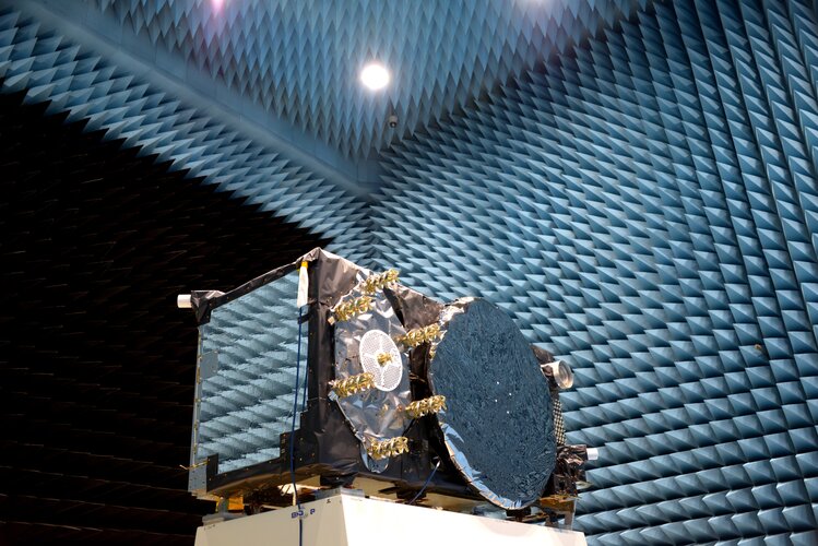
Europe’s Galileo satellite navigation system is providing the world’s most precise positioning services, but the satellites at its heart are surprisingly compact, and dependent on many different technologies to keep running. Here are 12 things you probably didn’t know about them:
USGIF Launches 2022 Scholarship Campaign
2.12.2021 1:12 GISCafe.com Webcasts-Webinars Foundation seeks donations toward collegiate geospatial intelligence educationHerndon, Virginia (December 1, 2021)—The United States …
NASA Expands its Commercial Data Acquisition Program with Airbus
2.12.2021 0:59 GISCafe.com Webcasts-Webinars @AirbusSpace @NASA #SatelliteImagery #Radar #SARHerndon, Virginia, USA. DD September 2021 - NASA has expanded the Commercial Smallsat Data …
Zemřel Miroslav Zikmund [Knihovna geografie, byTopic]
2.12.2021 0:00 Katedra aplikované geoinformatiky a kartografie Přf UK Ve středu 1.12.2021 se ve svých 102 letech vydal na svou poslední pouť známý cestovatel Ing. Miroslav Zikmund. Spolu s Jiřím Hanzelkou vytvořili legendární cestovatelskou dvojici, která navštívila přes 80 zemí světa a proslavila vozy Tatra a Československo. Čest jeho památce!Přednáška dr. Pöppla
2.12.2021 0:00 Geografický ústav MUV rámci programu INNOLEC zavítá na Geografický ústav dr. Ronald Pöppl z Vídeňské univerzity, který přednese přednášku na téma "Connectivity in geomorphology: Basic concepts and selected case studies". Přednáška se uskuteční v posluchárně Z3 ve čtvrtek 2. prosince v čase 10:30 až 12:00.
Dr. Pöppl se odborně věnuje problematice půdní eroze a konektivity transportu sedimentů v povodích.
Všichni zájemci jsou srdečně zváni.
Self sustainable Campus Project Wins Judges Choice Award
1.12.2021 20:41 Bentley SystemsPressCoverage
Using 3D Modeling and Digitalization to Design Mini-Modular Plant
Read the articleBentley Systems Announces the Year in Infrastructure 2021 Founders Honorees
1.12.2021 18:15 Bentley SystemsPress Announcements
Pleiades Neo Satellite Imagery is Now Available! Join the webinar
1.12.2021 18:12 GISCafe.com Webcasts-WebinarsRestoration Project to Preserve Strengthen Minneapolis Iconic Stone Arch Bridge
1.12.2021 18:02 Bentley SystemsPressCoverage
Collins Engineers Inc. Uses Innovative Reality Modeling Technology to Determine Necessary Repairs
Read the articleNGA Accelerator Seeks Third Cohort of Geospatial Technology Companies
1.12.2021 17:23 GISCafe.com Webcasts-Webinars NGA Accelerator will accept applications until Jan. 18 for its third cohort.ST. LOUIS, Mo., Dec. 1, 2021 — (PRNewswire) —
ST. LOUIS, …
DroneSense Assisted Emergency Teams at Surfside Building Collapse
1.12.2021 17:23 GISCafe.com Webcasts-Webinars AUSTIN, Texas, Dec. 01, 2021 (GLOBE NEWSWIRE) -- DroneSense responded to a Florida emergency service's need for assistance following the Surfside …ADLINK releases its first SMARC module based on Qualcomm QRB5165 enabling high performance robots and drones at low power
1.12.2021 17:23 GISCafe.com Webcasts-Webinars Integrated IoT technologies provide on-device AI capabilities at the edgeTAIPEI, Taiwan, Dec. 1, 2021 — (PRNewswire) —
TAIPEI, …
Airspace Link Partners with the City of Arlington, Texas, on Safer, Scalable Drone Solutions
1.12.2021 17:23 GISCafe.com Webcasts-Webinars ARLINGTON, Texas, Dec. 1, 2021 — (PRNewswire) — Airspace Link, Inc., a leading Detroit-based provider of drone mapping and …Sony Electronics' Airpeak S1 Professional Drone Now Available to Order
1.12.2021 17:23 GISCafe.com Webcasts-Webinars World's Smallest Alpha Mirrorless Camera-Ready Professional Drone Will Ship on December 24, 2021SAN DIEGO, Dec. 1, 2021 — (PRNewswire) — …
POWERCHINA Hubei Electric Engineering Develops One of a Kind Mountainous Solar Array
1.12.2021 17:11 Bentley SystemsPressCoverage
POWERCHINA Hubei Electric Engineering Develops One-of-a-Kind Mountainous Solar Array
Read the articlePOWERCHINA Hubei Electric Engineering Develops One of a Kind Mountainous Solar Array
1.12.2021 17:11 Bentley SystemsPressCoverage
POWERCHINA Hubei Electric Engineering
Read the articlePOWERCHINA Hubei Electric Engineering Develops One of a Kind Mountainous Solar Array
1.12.2021 17:11 Bentley SystemsPressCoverage
POWERCHINA Hubei Electric Engineering Develops One-of-a-Kind Mountainous Solar Array
Read the articleDen otevřených dveří
1.12.2021 16:13 Katedra geoinformatiky UP OlomoucDen otevřených dveří Univerzity Palackého se koná už tento pátek 3. 12. 2021 a opět online §Samozřejmě i Geoinformatika UPOL nemůže chybět Pro všechny zvědavé uchazeče budeme od 8 do 14:00 k dispozici na https://meet.vpsfree.cz/geoinformatika Takže neváhejte a připojte se
The post Den otevřených dveří appeared first on Katedra geoinformatiky.
Vrchní referent/rada v ekonomicko-správním oddělení v Kanceláři ředitele Katastrálního úřadu
1.12.2021 13:22 ČÚZK /Urady/Katastralni-urady/Katastralni-urady/Katastralni-urad-pro-Jihomoravsky-kraj/Volna-mista/DMS/Vrchni-referent-rada-v-ekonomicko-spravnim-oddelenVrchní referent/rada v ekonomicko-správním oddělení v Kanceláři ředitele Katastrálního úřadu
1.12.2021 13:22 ČÚZK - předpisy a opatření Katastrální úřad pro Jihomoravský kraj kancelář úřaduvypisuje výběrové řízení na místo
Vrchní referent/rada v ekonomicko-správním oddělení v Kanceláři ředitele Katastrálního úřadu
Vrchní referent/rada v ekonomicko-správním oddělení v Kanceláři ředitele Katastrálního úřadu
1.12.2021 13:22 ČÚZK - volná místa Katastrální úřad pro Jihomoravský kraj kancelář úřadu vypisuje výběrové řízení na místo Vrchní referent/rada v ekonomicko-správním oddělení v Kanceláři ředitele Katastrálního úřaduVychází nová verze nástroje ISKN Import
1.12.2021 10:19 ARCDATA
Nástroj ISKN Import pro aplikaci ArcGIS Pro slouží ke zpracování dat výměnného formátu katastru (VFK) ČÚZK pro použití v geodatabázi Esri. Nová verze ISKN Import 2.8.3 přináší několik nových funkcí a opravy chyb.
Novinky:
- Při importu pomocí konzole je možné importovat všechny VFK soubory z adresáře.
- Výpis a uložení shrnutí při importu z konzole.
- Šablona verze VFK 5.6.
- Akce Before a After Import, které odstraňují (nebo vytvářejí) atributové indexy a relační třídy, což zrychluje import více souborů najednou.
- Automatické otevření Nahlížení do KN při označení definičního bodu nemovitosti v mapě, ke kterému lokálně chybí popisné informace (ISKN View).
- Úprava názvů domén a číselníků (přidán prefix ISKN_), názvy relačních tříd začínají na "R_".
- Vytváření datového modelu je značně zrychleno.
Opraveno:
- Načítání tabulek a tříd prvků ze šablony a konfigurace.
- Vazba na tabulku KRAJE je nyní na NKRAJE (ISKN View).
- Parsování datumů ze souborů při běhu na operačním systému, který není v češtině.
- Adresa prokliknutí do KN pro budovu (ISKN View).
Zdarma si můžete stáhnout verzi ISKN Import Free, která umožňuje základní operace s daty dostupnými v rámci souboru VFK.
Používáte-li ještě ISKN Studio pro ArcMap, můžete si také stáhnout novou šablonu VFK 5.6 pro ISKN Studio.
Více informací o celé sadě nástrojů ISKN Import i o verzi ISKN Free naleznete na samostatné stránce.
Astun Technology appoints new Head of Sales to achieve 35% growth by 2025
1.12.2021 9:00 GISCafe.com Webcasts-Webinars Epsom, UK, 2 December 2021, (www.astuntechnology.com)Market-leading open source geospatial solutions provider, Astun Technology, has appointed Mark …
Spire Global, Inc. Completes Acquisition of exactEarth Ltd.
1.12.2021 0:59 GISCafe.com Webcasts-Webinars Combined company is a global leader in the space-based maritime data and analytics IndustrySpire gains approximately $18m ARR, 150+ customers, vast …
Belize, Costa Rica, and the Dominican Republic Select terraPulse to Map Forest
30.11.2021 22:12 GISCafe.com Webcasts-Webinars Producing data of unprecedented granularity and accuracy, program will support countries' natural asset protection and participation in global carbon …VESA Publishes Thousands of High-Resolution Video and Image Files for Unrestricted Public Use Resulting from 3D Video Compression Research Study with York University
30.11.2021 22:12 GISCafe.com Webcasts-Webinars Multi-year research contract with York University established to validate and improve VESA compression codecs for augmented/virtual/extended reality …GeoInfoStrategie2020+
30.11.2021 20:45 Ministerstvo vnitra Strategie rozvoje infrastruktury pro prostorové informace v České republice po roce 2020Swift Navigation’s Precise Positioning Solution with STMicroelectronics Teseo V Delivers Centimeter-Level Accurate Location Precision
30.11.2021 20:21 GISCafe.com Webcasts-Webinars SAN FRANCISCO, Nov. 30, 2021 (GLOBE NEWSWIRE) -- Swift Navigation, a San Francisco-based tech firm redefining GNSS (Global Navigation Satellite …S&P CoreLogic Case-Shiller Index Reports 19.5% Annual Home Price Gain In September
30.11.2021 20:21 GISCafe.com Webcasts-Webinars NEW YORK, Nov. 30, 2021 — (PRNewswire) — S&P Dow Jones Indices (S&P DJI) today released the latest results for the S&P …BlackSky Continues Aggressive Business Expansion Adding Two Satellites with Upcoming SpaceX Launch
30.11.2021 17:45 GISCafe.com Webcasts-Webinars Company looks to double constellation capacity in 2021HERNDON, Va. — (BUSINESS WIRE) — November 30, 2021 —
BlackSky (NYSE: BKSY) …
Skytec Selects Esri Technology to Power New Precision Conservation Management Application
30.11.2021 17:45 GISCafe.com Webcasts-Webinars Startup's Ranger App Uses Cloud-Hosted Drone and Satellite Imagery to Monitor User LandREDLANDS, Calif. — (BUSINESS WIRE) — November 30, …
HSR.health Announces Issuance of U.S. Patent to Identify Population At-Risk of Opioid Addiction
30.11.2021 17:45 GISCafe.com Webcasts-Webinars The patent covers the use of HSR.health's novel geospatial and AI-based approach to help mitigate the growing opioid epidemic.ROCKVILLE, Md., Nov. …
Introducing TomTom IndiGO: The world’s first open digital cockpit software platform for carmakers
30.11.2021 17:45 GISCafe.com Webcasts-Webinars AMSTERDAM, Nov. 30, 2021 (GLOBE NEWSWIRE) -- TomTom (TOM2), the geolocation technology specialist, today unveiled TomTom IndiGO, the world’s …Kartograf/ka
30.11.2021 13:39 ČÚZK - předpisy a opatření Zeměměřický úřadvypisuje výběrové řízení na místo
Kartograf/ka
Kartograf/ka
30.11.2021 13:39 Zeměměřický úřad Zeměměřický úřadvypisuje výběrové řízení na místo
Kartograf/ka
Kartograf/ka
30.11.2021 13:39 ČÚZK - volná místa Zeměměřický úřad vypisuje výběrové řízení na místo Kartograf/kaGalileo satellites placed on Soyuz launcher
30.11.2021 13:28 ESA Navigation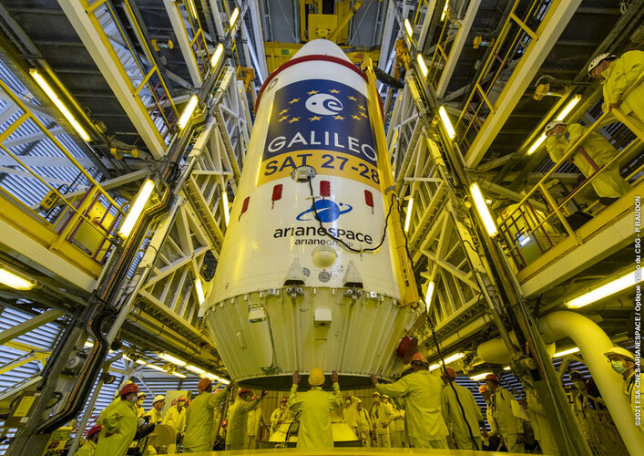 Image:
Galileo satellites placed on Soyuz launcher
Image:
Galileo satellites placed on Soyuz launcher
Schránka pro příjem podání
30.11.2021 12:20 ČÚZK - předpisy a opatření Katastrální úřad pro Královéhradecký kraj - Katastrální pracoviště Trutnov zveřejnil novou aktualitu: Vážení klienti,s účinností od 01. 12. 2021 je na Katastrálním pracovišti Trutnov instalována schránka pro příjem podání. Tato schránka je určena pro bezkontaktní podání návrhů na vklad a dalších písemností určených tomuto pracovišti. Schránka je pravidelně vybírána, okamžikem podání je okamžik výběru schránky. Příjem podání bude potvrzen spolu s případným podkladem pro platbu správního poplatku na Vámi sdělenou e-mailovou adresu.