


![]()

zprávy
zdroje zpráv:Ransomware EKANS napadá průmyslové řídící systémy
24.2.2020 15:25 GeoBusinessFirma Acronis poslala upozornění na ransomware Ekans (pozpátku „snake“), který napadá průmyslové řídící systémy. Ransomware se objevil v prosinci 2019, ve své výzkumné zprávě na něj své zákazníky upozornila bezpečnostní firma Dragos, která později kvůli zájmu o tento vyděračský software zveřejnila celou zprávu. Ransomware EKANS zastavuje určité procesy v průmyslových řídících systémech (vodárenství, plynárenství, elektrárenství, […]
The post Ransomware EKANS napadá průmyslové řídící systémy appeared first on GeoBusiness.
20200225- seznam oprávněných zeměměřických inženýrů
24.2.2020 14:25 ČÚZK - předpisy a opatření Český úřad zeměměřický a katastrální zveřejnil novou aktualitu: Aktualizovaný seznam úředně oprávněných zeměměřických inženýrů.20200225- seznam oprávněných zeměměřických inženýrů
24.2.2020 14:25 ČÚZK /Aktuality-resort/2020/20200225-seznamopravnenych-zememerickych-inzenyru12 nejlepších webů, kde hledat modely pro 3D tisk, obrábění a vizualizace
24.2.2020 14:08 Konstruktér Proč znovu vynalézat kolo, když to už před vámi udělali jiní? Stejně tak můžete ušetřit [...]Výroční zpráva dle zákona č. 106/1999 Sb. za rok 2019
24.2.2020 14:06 ČÚZK - předpisy a opatření Katastrální úřad pro Středočeský krajvydává výroční zprávu úřadu za rok
2019
Výběrové řízení na služební místo interní auditor
24.2.2020 13:05 ČÚZK - předpisy a opatření Katastrální úřad pro Plzeňský kraj zveřejnil novou aktualitu: Ředitel Katastrálního úřadu pro Plzeňský kraj jako služební orgán příslušný podle § 10 odst. 1 písm. f) zákona č. 234/2014 Sb., o státní službě ve znění pozdějších předpisů, vyhlašuje Výběrové řízení na služební místo interní auditor – IA, Katastrální úřad pro Plzeňský kraj, v oboru služby 3. Audit.Výběrové řízení na služební místo interní auditor
24.2.2020 13:05 ČÚZK /Urady/Katastralni-urady/Katastralni-urady/Katastralni-urad-pro-Plzensky-kraj/O-uradu/Aktuality/Vyberove-rizeni-na-sluzebni-misto-interni-auditorVýběrové řízení na služební místo interní auditor
24.2.2020 13:01 ČÚZK /Urady/Katastralni-urady/Katastralni-urady/Katastralni-urad-pro-Plzensky-kraj/Uredni-deska/Oznameni-a-jina-uredni-sdeleni/Volna-mista/DMS/Vyberove-rizeni-na-sluzebni-misto-interni-auditorVýběrové řízení na služební místo interní auditor
24.2.2020 13:01 ČÚZK - volná místa Katastrální úřad pro Plzeňský kraj vypisuje výběrové řízení na místo Výběrové řízení na služební místo interní auditorVýběrové řízení na služební místo interní auditor
24.2.2020 13:01 ČÚZK - předpisy a opatření Katastrální úřad pro Plzeňský krajvypisuje výběrové řízení na místo
Výběrové řízení na služební místo interní auditor
166 388 geometrických plánů v roce 2019, uvádí výroční zpráva ČÚZK za rok 2019
24.2.2020 11:41 ZeměměřičDne 19. února 2020 uveřejnil Český úřad zeměměřický a katastrální výroční zprávu za rok 2019, obsahující údaje, které by mohly (a měly) zajímat čtenáře Zeměměřiče. Údaje můžeme rozdělit do tří částí – výkony v oboru katastru nemovitostí, výkony v oboru zeměměřictví, personální a ekonomické údaje. Výkony v oboru katastru nemovitostí Katastrální pracoviště přijala 925 373 návrhů na vklad práv do katastru nemovitostí a 95 % […]
The post 166 388 geometrických plánů v roce 2019, uvádí výroční zpráva ČÚZK za rok 2019 appeared first on Zeměměřič.
Výroční zpráva ČÚZK za rok 2019 – co se dělo v resortu ČÚZK
24.2.2020 11:41 ZeměměřičDne 19. února 2020 uveřejnil Český úřad zeměměřický a katastrální výroční zprávu za rok 2019, obsahující údaje, které by mohly (a měly) zajímat čtenáře Zeměměřiče. Údaje můžeme rozdělit do tří částí – výkony v oboru katastru nemovitostí, výkony v oboru zeměměřictví, personální a ekonomické údaje. Výkony v oboru katastru nemovitostí Katastrální pracoviště přijala 925 373 návrhů na vklad práv do katastru nemovitostí a 95 % […]
The post Výroční zpráva ČÚZK za rok 2019 – co se dělo v resortu ČÚZK appeared first on Zeměměřič.
APG společně s APÚ a ČMKPÚ jedná s SPÚ o změnách v zadávací dokumentaci
24.2.2020 11:26 ZeměměřičStátní pozemkový úřad před časem vyhlásil výzvu k předběžné tržní konzultaci. Asociace podnikatelů v geomatice (APG) se spojila s APÚ (Asociace pozemkových úprav) a ČMKPÚ (Českomoravská komora pozemkových úprav) a společně jednotnou cestou jednají se Státním pozemkovým úřadem o změně zadávací dokumentace. Nová zadávací dokumentace by měla odrážet současný stav pozemkových úprav a princip rovnoprávného postavení zadavatele a zpracovatele. Cílem předběžné tržní konzultace […]
The post APG společně s APÚ a ČMKPÚ jedná s SPÚ o změnách v zadávací dokumentaci appeared first on Zeměměřič.
VZ: Komplexní pozemkové úpravy v k. ú. Eš
24.2.2020 10:54 ZeměměřičPředmětem plnění podlimitní veřejné zakázky na služby je zpracování návrhu komplexních pozemkových úprav (dále jen „KoPÚ“) v katastrálním území Eš, včetně nezbytných geodetických prací v třídě přesnosti určené pro obnovu katastru nemovitostí vyhláškou č. 357/2013 Sb. Do obvodu komplexních pozemkových úprav bude zahrnuto celé katastrální území Eš, mimo zastavěné území obce Eš a dále mimo komplex rekreačních objektů v lesním […]
The post VZ: Komplexní pozemkové úpravy v k. ú. Eš appeared first on Zeměměřič.
Mapy jsou pro každého nově pořádá Michal Souček s Drahou Zedníčkovou
24.2.2020 10:47 GeoBusinessPo dlouholeté úspěšné spolupráci s Nadací Partnerství pořádá konferenci Mapy jsou pro každého nově konzultant Michal Souček ve spolupráci s Drahomírou Zedníčkovou z firmy TopGis. Letošní ročník konference se uskuteční opět v hotelu Luna nedaleko Ledče nad Sázavou. Konference Mapy jsou pro každého je především o poznání, sdílení zkušeností, vzájemné inspiraci a někdy i o výměně […]
The post Mapy jsou pro každého nově pořádá Michal Souček s Drahou Zedníčkovou appeared first on GeoBusiness.
Looking for funding? The EIC may have something for you!
24.2.2020 10:19 European GNSS Agency
The European Innovation Council (EIC) has as its goal to put Europe on top of the next wave of breakthrough and disruptive innovation that creates new markets. Space-based technology fits this profile and there are number of funding opportunities available under open EIC calls that may be of interest to space-tech innovators.
Support for deep-tech, high-risk SMEs and innovators
One such opportunity is the EIC Accelerator Pilot (previously known as the SME Instrument), which supports innovative, high-potential SMEs to develop and bring to market new products, services and business models. The EIC Accelerator supports, for example, trials, prototyping, validation, demonstration and testing in real-world conditions, and market replication.
Projects will receive between EUR 0.5 and EUR 2.5 million in the form of grants. The EIC Accelerator also offers blended finance in the form of an optional investment in equity in addition to the grant, to single for-profit SMEs. Grants will finance activities from Technology Readiness Levels (TRL) 6-8. Activities above TRL 8 will financed only through blended finance. You can find a map of current EIC Accelerator companies here. The next cut-off date for applications is 18 March 2020. You can apply here.
Novel ideas for radically new technologies
Another opportunity is the Future and Emerging Technologies (FET) Open call Novel ideas for radically new technologies, which is looking for proposals for cutting-edge, high-risk or high-impact interdisciplinary research. This research should have a radical vision and target a novel and ambitious science-to-technology breakthrough that opens up new areas of investigation.
FET Open aims to establish European leadership in the early exploration of future technologies. It looks for opportunities that are of long-term benefit for citizens, the economy and society. With this aim in mind, it strives to mobilise Europe's most creative and forward-thinking researchers from all disciplines to work together and explore possible leading technology paradigms of the future.
Cutting-edge innovation
Last year, as part of its Pathfinder pilot (FET-Proactive) Boosting emerging technologies call, the EIC looked for proposals for projects that aimed to demonstrate a new technological paradigm for human-centric Artificial Intelligence, contributing to the wider debate on the sociotechnical, organisational and AI-ethical dimensions of these technologies and systems. Also targeted were proposals for implantable autonomous biomedical devices and materials and breakthrough solutions for zero-emissions energy generation.
Read this: Last calls for Horizon 2020, first views for Horizon Europe
FET Proactive aimed to identify the future and emerging technologies with the highest economic and societal potential. It looked to establish a broad and solid European basis in terms of knowledge, key technological building blocks and interdisciplinary communities to ensure that Europe has the best 'first mover' position to capitalise rapidly and effectively on emerging societal and industrial opportunities.
EGNSS R&D White Paper
The European GNSS Agency (GSA) has gathered input from EGNSS (Galileo and EGNOS) users, confirming the importance of investing in the development of EGNSS downstream applications in order to capture economic and technological returns.
This can be achieved by identifying the priority areas for investing in downstream applications by market segment; analysing the different funding tools that could support EGNSS market uptake; and describing the desirable characteristics that define best practices for EGNSS R&D programmes.
The results of this research have been complied in a White Paper outlining recommendations for areas of focus and innovation funding for EGNSS R&D, which is available for download here.
Media note: This feature can be republished without charge provided the European GNSS Agency (GSA) is acknowledged as the source at the top or the bottom of the story. You must request permission before you use any of the photographs on the site. If you republish, we would be grateful if you could link back to the GSA website (http://www.gsa.europa.eu).
Looking for funding? The EIC may have something for you!
24.2.2020 10:19 European GNSS AgencyThe European Innovation Council (EIC) has as its goal to put Europe on top of the next wave of breakthrough and disruptive innovation that creates new markets. Space-based technology fits this profile and there are number of funding opportunities available under open EIC calls that may be of interest to space-tech innovators.
Support for deep-tech, high-risk SMEs and innovators
One such opportunity is the EIC Accelerator Pilot (previously known as the SME Instrument), which supports innovative, high-potential SMEs to develop and bring to market new products, services and business models. The EIC Accelerator supports, for example, trials, prototyping, validation, demonstration and testing in real-world conditions, and market replication.
Projects will receive between EUR 0.5 and EUR 2.5 million in the form of grants. The EIC Accelerator also offers blended finance in the form of an optional investment in equity in addition to the grant, to single for-profit SMEs. Grants will finance activities from Technology Readiness Levels (TRL) 6-8. Activities above TRL 8 will financed only through blended finance. You can find a map of current EIC Accelerator companies here. The next cut-off date for applications is 18 March 2020. You can apply here.
Novel ideas for radically new technologies
Another opportunity is the Future and Emerging Technologies (FET) Open call Novel ideas for radically new technologies, which is looking for proposals for cutting-edge, high-risk or high-impact interdisciplinary research. This research should have a radical vision and target a novel and ambitious science-to-technology breakthrough that opens up new areas of investigation.
FET Open aims to establish European leadership in the early exploration of future technologies. It looks for opportunities that are of long-term benefit for citizens, the economy and society. With this aim in mind, it strives to mobilise Europe's most creative and forward-thinking researchers from all disciplines to work together and explore possible leading technology paradigms of the future.
Cutting-edge innovation
As part of its Pathfinder pilot (FET-Proactive) Boosting emerging technologies call, the EIC looked for proposals for projects that aimed to demonstrate a new technological paradigm for human-centric Artificial Intelligence, contributing to the wider debate on the sociotechnical, organisational and AI-ethical dimensions of these technologies and systems. Also targeted were proposals for implantable autonomous biomedical devices and materials and breakthrough solutions for zero-emissions energy generation.
Read this: Last calls for Horizon 2020, first views for Horizon Europe
FET Proactive aims to identify the future and emerging technologies with the highest economic and societal potential. It looks to establish a broad and solid European basis in terms of knowledge, key technological building blocks and interdisciplinary communities to ensure that Europe has the best 'first mover' position to capitalise rapidly and effectively on emerging societal and industrial opportunities.
EGNSS R&D White Paper
The European GNSS Agency (GSA) has gathered input from EGNSS (Galileo and EGNOS) users, confirming the importance of investing in the development of EGNSS downstream applications in order to capture economic and technological returns.
This can be achieved by identifying the priority areas for investing in downstream applications by market segment; analysing the different funding tools that could support EGNSS market uptake; and describing the desirable characteristics that define best practices for EGNSS R&D programmes.
The results of this research have been complied in a White Paper outlining recommendations for areas of focus and innovation funding for EGNSS R&D, which is available for download here.
Media note: This feature can be republished without charge provided the European GNSS Agency (GSA) is acknowledged as the source at the top or the bottom of the story. You must request permission before you use any of the photographs on the site. If you republish, we would be grateful if you could link back to the GSA website (http://www.gsa.europa.eu).
Looking for funding? The EIC may have something for you!
24.2.2020 10:19 European GNSS AgencySupport for deep-tech, high-risk SMEs and innovators
One such opportunity is the EIC Accelerator Pilot (previously known as the SME Instrument), which supports innovative, high-potential SMEs to develop and bring to market new products, services and business models. The EIC Accelerator supports, for example, trials, prototyping, validation, demonstration and testing in real-world conditions, and market replication.
Projects will receive between EUR 0.5 and EUR 2.5 million in the form of grants. The EIC Accelerator also offers blended finance in the form of an optional investment in equity in addition to the grant, to single for-profit SMEs. Grants will finance activities from Technology Readiness Levels (TRL) 6-8. Activities above TRL 8 will financed only through blended finance. You can find a map of current EIC Accelerator companies here. The next cut-off date for applications is 18 March 2020. You can apply here.
Novel ideas for radically new technologies
Another opportunity is the Future and Emerging Technologies (FET) Open call Novel ideas for radically new technologies, which is looking for proposals for cutting-edge, high-risk or high-impact interdisciplinary research. This research should have a radical vision and target a novel and ambitious science-to-technology breakthrough that opens up new areas of investigation.
FET Open aims to establish European leadership in the early exploration of future technologies. It looks for opportunities that are of long-term benefit for citizens, the economy and society. With this aim in mind, it strives to mobilise Europe's most creative and forward-thinking researchers from all disciplines to work together and explore possible leading technology paradigms of the future.
Cutting-edge innovation
As part of its Pathfinder pilot (FET-Proactive) Boosting emerging technologies call, the EIC looked for proposals for projects that aimed to demonstrate a new technological paradigm for human-centric Artificial Intelligence, contributing to the wider debate on the sociotechnical, organisational and AI-ethical dimensions of these technologies and systems. Also targeted were proposals for implantable autonomous biomedical devices and materials and breakthrough solutions for zero-emissions energy generation.
Read this: Last calls for Horizon 2020, first views for Horizon Europe
FET Proactive aims to identify the future and emerging technologies with the highest economic and societal potential. It looks to establish a broad and solid European basis in terms of knowledge, key technological building blocks and interdisciplinary communities to ensure that Europe has the best 'first mover' position to capitalise rapidly and effectively on emerging societal and industrial opportunities.
EGNSS R&D White Paper
The European GNSS Agency (GSA) has gathered input from EGNSS (Galileo and EGNOS) users, confirming the importance of investing in the development of EGNSS downstream applications in order to capture economic and technological returns.
This can be achieved by identifying the priority areas for investing in downstream applications by market segment; analysing the different funding tools that could support EGNSS market uptake; and describing the desirable characteristics that define best practices for EGNSS R&D programmes.
The results of this research have been complied in a White Paper outlining recommendations for areas of focus and innovation funding for EGNSS R&D, which is available for download here.
Media note: This feature can be republished without charge provided the European GNSS Agency (GSA) is acknowledged as the source at the top or the bottom of the story. You must request permission before you use any of the photographs on the site. If you republish, we would be grateful if you could link back to the GSA website (http://www.gsa.europa.eu).
Looking for funding? The EIC may have something for you!
24.2.2020 10:19 European GNSS AgencyThe European Innovation Council (EIC) has as its goal to put Europe on top of the next wave of breakthrough and disruptive innovation that creates new markets. Space-based technology fits this profile and there are number of funding opportunities available under open EIC calls that may be of interest to space-tech innovators.
Support for deep-tech, high-risk SMEs and innovators
One such opportunity is the EIC Accelerator Pilot (previously known as the SME Instrument), which supports innovative, high-potential SMEs to develop and bring to market new products, services and business models. The EIC Accelerator supports, for example, trials, prototyping, validation, demonstration and testing in real-world conditions, and market replication.
Projects will receive between EUR 0.5 and EUR 2.5 million in the form of grants. The EIC Accelerator also offers blended finance in the form of an optional investment in equity in addition to the grant, to single for-profit SMEs. Grants will finance activities from Technology Readiness Levels (TRL) 6-8. Activities above TRL 8 will financed only through blended finance. You can find a map of current EIC Accelerator companies here. The next cut-off date for applications is 18 March 2020. You can apply here.
Novel ideas for radically new technologies
Another opportunity is the Future and Emerging Technologies (FET) Open call Novel ideas for radically new technologies, which is looking for proposals for cutting-edge, high-risk or high-impact interdisciplinary research. This research should have a radical vision and target a novel and ambitious science-to-technology breakthrough that opens up new areas of investigation.
FET Open aims to establish European leadership in the early exploration of future technologies. It looks for opportunities that are of long-term benefit for citizens, the economy and society. With this aim in mind, it strives to mobilise Europe's most creative and forward-thinking researchers from all disciplines to work together and explore possible leading technology paradigms of the future.
Other funding is available
If your profile does not fit any of the above opportunities, take a look at this Guide to European GNSS Funding Mechanisms, recently published by the GSA. This funding guide provides a snapshot of the various funding mechanisms available to any team or individual working on an EGNOS/Galileo technology or application.
The guide illustrates the nature of the various funding mechanisms, explains their target applicants, the markets in which they operate, and the funding envelopes they can be expected to provide. It also highlights the eligibility criteria, if any, and the additional support mechanisms for each project.
Cutting-edge innovation
Last year, as part of its Pathfinder pilot (FET-Proactive) Boosting emerging technologies call, the EIC looked for proposals for projects that aimed to demonstrate a new technological paradigm for human-centric Artificial Intelligence, contributing to the wider debate on the sociotechnical, organisational and AI-ethical dimensions of these technologies and systems. Also targeted were proposals for implantable autonomous biomedical devices and materials and breakthrough solutions for zero-emissions energy generation.
Read this: Last calls for Horizon 2020, first views for Horizon Europe
FET Proactive aimed to identify the future and emerging technologies with the highest economic and societal potential. It looked to establish a broad and solid European basis in terms of knowledge, key technological building blocks and interdisciplinary communities to ensure that Europe has the best 'first mover' position to capitalise rapidly and effectively on emerging societal and industrial opportunities.
EGNSS R&D White Paper
The European GNSS Agency (GSA) has gathered input from EGNSS (Galileo and EGNOS) users, confirming the importance of investing in the development of EGNSS downstream applications in order to capture economic and technological returns.
This can be achieved by identifying the priority areas for investing in downstream applications by market segment; analysing the different funding tools that could support EGNSS market uptake; and describing the desirable characteristics that define best practices for EGNSS R&D programmes.
The results of this research have been complied in a White Paper outlining recommendations for areas of focus and innovation funding for EGNSS R&D, which is available for download here.
Media note: This feature can be republished without charge provided the European GNSS Agency (GSA) is acknowledged as the source at the top or the bottom of the story. You must request permission before you use any of the photographs on the site. If you republish, we would be grateful if you could link back to the GSA website (http://www.gsa.europa.eu).
Inzerát_PP na referent KN-vedení katastrální mapy
24.2.2020 10:13 ČÚZK - volná místa Katastrální úřad pro hlavní město Prahu vypisuje výběrové řízení na místo Inzerát_PP na referent KN-vedení katastrální mapyreferent KN – vedení DKM, vedení katastrální mapy (10. pt.)
24.2.2020 10:13 ČÚZK - předpisy a opatření Katastrální úřad pro hlavní město Prahuvypisuje výběrové řízení na místo
referent KN – vedení DKM, vedení katastrální mapy (10. pt.)
referent KN – vedení DKM, vedení katastrální mapy (10. pt.)
24.2.2020 10:13 ČÚZK /Urady/Katastralni-urady/Katastralni-urady/Katastralni-urad-pro-hlavni-mesto-Prahu/Volna-mista/DMS/Inzerat_PP-na-referent-KN-vedeni-katastralni-mapy1referent KN – vedení DKM, vedení katastrální mapy (10. pt.)
24.2.2020 10:13 ČÚZK - volná místa Katastrální úřad pro hlavní město Prahu vypisuje výběrové řízení na místo referent KN – vedení DKM, vedení katastrální mapy (10. pt.)referent KN – právník do právního oddělení XI.
24.2.2020 9:40 ČÚZK - předpisy a opatření Katastrální úřad pro hlavní město Prahuvypisuje výběrové řízení na místo
referent KN – právník do právního oddělení XI.
referent KN – právník do právního oddělení XI.
24.2.2020 9:40 ČÚZK /Urady/Katastralni-urady/Katastralni-urady/Katastralni-urad-pro-hlavni-mesto-Prahu/Volna-mista/DMS/Inzerat_PP_na_pravnik_PO_XIInzerát_PP_na_právník_PO_XI
24.2.2020 9:40 ČÚZK - předpisy a opatření Katastrální úřad pro hlavní město Prahuvypisuje výběrové řízení na místo
Inzerát_PP_na_právník_PO_XI
referent KN – právník do právního oddělení XI.
24.2.2020 9:40 ČÚZK - volná místa Katastrální úřad pro hlavní město Prahu vypisuje výběrové řízení na místo referent KN – právník do právního oddělení XI.Inzerát_PP_na_právník_PO_XI
24.2.2020 9:40 ČÚZK - volná místa Katastrální úřad pro hlavní město Prahu vypisuje výběrové řízení na místo Inzerát_PP_na_právník_PO_XIInzerát_PP_na_právník_PO_XI
24.2.2020 9:40 ČÚZK /Urady/Katastralni-urady/Katastralni-urady/Katastralni-urad-pro-hlavni-mesto-Prahu/Volna-mista/DMS/Inzerat_PP_na_pravnik_PO_XIAnalytik IKT v Sedlčanech
24.2.2020 9:19 Zeměměřický úřad Zeměměřický úřadvypisuje výběrové řízení na místo
Analytik IKT v Sedlčanech
Analytik IKT v Sedlčanech
24.2.2020 9:19 ČÚZK - předpisy a opatření Zeměměřický úřadvypisuje výběrové řízení na místo
Analytik IKT v Sedlčanech
Analytik IKT v Sedlčanech
24.2.2020 9:19 ČÚZK /Urady/Zememericky-urad/Volna-mista/Analytik-IKT-v-SedlcanechAnalytik IKT v Sedlčanech
24.2.2020 9:19 ČÚZK - volná místa Zeměměřický úřad vypisuje výběrové řízení na místo Analytik IKT v Sedlčanechreferent KN – vedení DKM, vedení katastrální mapy
24.2.2020 9:16 ČÚZK /Urady/Katastralni-urady/Katastralni-urady/Katastralni-urad-pro-hlavni-mesto-Prahu/Volna-mista/DMS/Inzerat_PP-na-referent-KN-vedeni-katastralni-mapyreferent KN – vedení DKM, vedení katastrální mapy
24.2.2020 9:16 ČÚZK - předpisy a opatření Katastrální úřad pro hlavní město Prahuvypisuje výběrové řízení na místo
referent KN – vedení DKM, vedení katastrální mapy
Inzerát_PP na referent KN-vedení katastrální mapy
24.2.2020 9:16 ČÚZK - volná místa Katastrální úřad pro hlavní město Prahu Katastrální pracoviště Praha vypisuje výběrové řízení na místo Inzerát_PP na referent KN-vedení katastrální mapyInzerát_PP na referent KN-vedení katastrální mapy
24.2.2020 9:16 ČÚZK /Urady/Katastralni-urady/Katastralni-urady/Katastralni-urad-pro-hlavni-mesto-Prahu/Volna-mista/DMS/Inzerat_PP-na-referent-KN-vedeni-katastralni-mapyreferent KN – vedení DKM, vedení katastrální mapy
24.2.2020 9:16 ČÚZK - volná místa Katastrální úřad pro hlavní město Prahu vypisuje výběrové řízení na místo referent KN – vedení DKM, vedení katastrální mapyInzerát_PP na referent KN-vedení katastrální mapy
24.2.2020 9:16 ČÚZK - předpisy a opatření Katastrální úřad pro hlavní město Prahu Katastrální pracoviště Prahavypisuje výběrové řízení na místo
referent KN – vedení DKM, vedení katastrální mapy
Jak efektivně navrhovat potrubí ve 3D CADu?
24.2.2020 8:39 Konstruktér Návrh komplexních potrubních systémů vyžaduje přesné plánování s využitím 3D CAD systémů. Konstrukci potrubních systémů [...]GIS Ostrava v termínu 18. až 20. 3. 2020 v Nové aule VŠB-TU Ostrava
21.2.2020 17:48 Společnost pro fotogrammetrii a dálkový průzkumKatedra geoinformatiky VŠB-TU Ostrava vás zve na již tradiční mezinárodní symposium GIS Ostrava, které sa uskuteční v termínu 18. až 20. 3. 2020 v Nové aule VŠB-TU Ostrava. Sympozium má samostatnou českou konferenci, jejíž letošním nosným tématem jsou „Prostorová data pro Smart City a Smart Region“ a anglickou konferenci s nosným tématem „UAV in Smart City and Smart Region“. Klíčovými řečníky jsou Francesco Nex z University of Twente a Jakub Karas ze společnosti UpVision. V rámci symposia proběhne několik zajímavých seminářů českých a zahraničních odborníků: Towards real-time UAV mapping (Francesco Nex, University of Twente) Dense Image Matching and Multi View Stereo in Urban Areas (Fabio Remondino, FBK Trento) The role of Vienna‘s geoinfrastructure in Viennese Smart City Initiatives (Franz Xaver Pfaffenbichler, City of Vienna) Geodesign (Jaroslav Burian, UP Olomouc) Využití konceptu Big Data v kontextu udržitelné mobility a řešení RODOS (Marek Šcerba, VŠB-TUO) Možnosti využití jazyka R jako skriptovacího nástroje pro GIS na příkladech QGIS a ArcGIS (Jan Caha, Mendelova univerzita Brno) BIM ve stavitelství Více informací naleznete na adrese http://gisak.vsb.cz/gisostrava/cz/index.php.
The post GIS Ostrava v termínu 18. až 20. 3. 2020 v Nové aule VŠB-TU Ostrava appeared first on SFDP.
GIS Ostrava v termínu 18. až 20. 3. 2020 v Nové aule VŠB-TU Ostrava
21.2.2020 17:48 Společnost pro fotogrammetrii a dálkový průzkumKatedra geoinformatiky VŠB-TU Ostrava vás zve na již tradiční mezinárodní symposium GIS Ostrava, které sa uskuteční v termínu 18. až 20. 3. 2020 v Nové aule VŠB-TU Ostrava. Sympozium má samostatnou českou konferenci, jejíž letošním nosným tématem jsou „Prostorová data pro Smart City a Smart Region“ a anglickou konferenci s nosným tématem „UAV in Smart City and Smart Region“. Klíčovými řečníky jsou Francesco Nex z University of Twente a Jakub Karas ze společnosti UpVision. V rámci symposia proběhne několik zajímavých seminářů českých a zahraničních odborníků: Towards real-time UAV mapping (Francesco Nex, University of Twente) Dense Image Matching and Multi View Stereo in Urban Areas (Fabio Remondino, FBK Trento) The role of Vienna‘s geoinfrastructure in Viennese Smart City Initiatives (Franz Xaver Pfaffenbichler, City of Vienna) Geodesign (Jaroslav Burian, UP Olomouc) Využití konceptu Big Data v kontextu udržitelné mobility a řešení RODOS (Marek Šcerba, VŠB-TUO) Možnosti využití jazyka R jako skriptovacího nástroje pro GIS na příkladech QGIS a ArcGIS (Jan Caha, Mendelova univerzita Brno) BIM ve stavitelství Více informací naleznete na adrese http://gisak.vsb.cz/gisostrava/cz/index.php.
The post GIS Ostrava v termínu 18. až 20. 3. 2020 v Nové aule VŠB-TU Ostrava appeared first on SFDP.
NM Group Announce London Dates for Latest PLS-CADD™ Training Seminar
21.2.2020 15:59 GISCafe.com Webcasts-Webinars KNARESBOROUGH, England, Feb. 21, 2020 — (PRNewswire) — NM Group, in association with Power Line Systems (PLS), has announced their next …Counterpoint Research: Fugro, PTC and Mapbox Lead the Spatial Intelligence Platform Capabilities
21.2.2020 15:59 GISCafe.com Webcasts-Webinars WRLD, Nomoko and Gamesim are providing customized solutions while NavVis, Enertiv, Siradel Engie and SketchUp are developing niche categoriesNEW …
Nová služba - termokamery pro únik tepla
21.2.2020 15:55 Hrdlička V nedávné době jsme začali našim zákazníkům nabízet měření termokamerou..HRDLIČKA spol. s r.o. - Nová služba - termokamery pro únik tepla
21.2.2020 15:55 Hrdlička V nedávné době jsme začali našim zákazníkům nabízet měření termokamerou..APEI first to purchase Leica CityMapper-2
21.2.2020 10:26 GISCafe.com Webcasts-Webinars WASHINTON, D.C., USA (20 February 2020) — Hexagon’s Geosystems division announced today Aero Photo Europe Investigation (APEI), …FM:Systems Announces 2019 Record Growth and Expansion
21.2.2020 10:03 GISCafe.com Webcasts-Webinars Powered by Acquisitions and Executive HiresRaleigh, N.C. – Feb. 20, 2020 – FM:Systems, a provider of solutions that enable facility and …
Earth from Space: Houston, Texas
21.2.2020 10:00 ESA Observing the Earth Video:
00:02:55
Video:
00:02:55
In this week's edition of the Earth from Space programme, the Copernicus Sentinel-1 mission takes us over Houston, the most populous city in Texas and the fourth largest in the US.
See also Houston, Texas to download the image.
In this week's edition of the Earth from Space programme, the Copernicus Sentinel-1 mission takes us over Houston, the most populous city in Texas and the fourth largest in the US.
See also Houston, Texas to download the image.
Earth from Space: Houston, Texas
21.2.2020 10:00 ESA Observing the Earth
Video:
00:02:55
In this week's edition of the Earth from Space programme, the Copernicus Sentinel-1 mission takes us over Houston, the most populous city in Texas and the fourth largest in the US.
See also Houston, Texas to download the image.
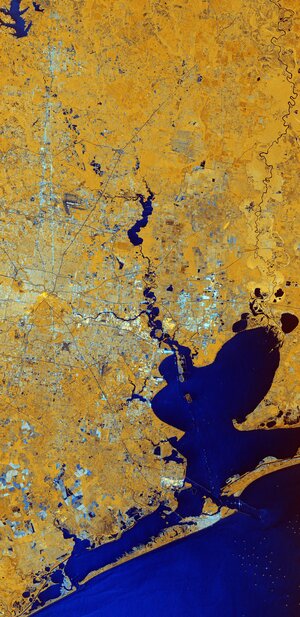 Image:
Houston, Texas
Image:
Houston, Texas
"AA Salt Doubles Productivity with Cloud-Based Mobile Workforce System BigChange" by Susan Smith
21.2.2020 9:00 GISCafe.com Webcasts-WebinarsMaxar Technologies Fourth Quarter 2019 Investor Call Scheduled for Monday, March 2, 2020
21.2.2020 9:00 GISCafe.com Webcasts-Webinars WESTMINSTER, Colo. — (BUSINESS WIRE) — February 19, 2020 — Maxar Technologies (NYSE:MAXR) (TSX:MAXR) plans to release its fourth …20200221 - volné místo - Ředitel/ředitelka kanceláře ředitele katastrálního úřadu na KÚ pro Úst.kraj
21.2.2020 7:44 ČÚZK - předpisy a opatření Katastrální úřad pro Ústecký kraj zveřejnil novou aktualitu: Nabídka volného pracovního místa - Ředitel / ředitelka kanceláře ředitele katastrálního úřadu na KÚ pro Ústecký kraj20200221 - volné místo - Ředitel/ředitelka kanceláře ředitele katastrálního úřadu na KÚ pro Úst.kraj
21.2.2020 7:44 ČÚZK /Urady/Katastralni-urady/Katastralni-urady/Katastralni-urad-pro-Ustecky-kraj/O-uradu/Aktuality/20200221-volne-misto-Reditel-reditelka-kancela20200221 - volné místo - Ředitel/ředitelka kanceláře ředitele katastrálního úřadu na KÚ pro Úst.kraj
21.2.2020 7:44 ČÚZK - předpisy a opatření Katastrální úřad pro Ústecký kraj zveřejnil novou aktualitu: Nabídka volného pracovního místa - Ředitel / ředitelka kanceláře ředitele katastrálního úřadu na KÚ pro Ústecký krajŘeditel / ředitelka kanceláře ředitele katastrálního úřadu na Katastrálním úřadu pro Ústecký kraj
21.2.2020 7:26 ČÚZK - předpisy a opatření Katastrální úřad pro Ústecký kraj kancelář ředitelevypisuje výběrové řízení na místo
Ředitel / ředitelka kanceláře ředitele katastrálního úřadu na Katastrálním úřadu pro Ústecký kraj
Ředitel / ředitelka kanceláře ředitele katastrálního úřadu na Katastrálním úřadu pro Ústecký kraj
21.2.2020 7:26 ČÚZK - volná místa Katastrální úřad pro Ústecký kraj kancelář ředitele vypisuje výběrové řízení na místo Ředitel / ředitelka kanceláře ředitele katastrálního úřadu na Katastrálním úřadu pro Ústecký krajŘeditel / ředitelka kanceláře ředitele katastrálního úřadu na Katastrálním úřadu pro Ústecký kraj
21.2.2020 7:26 ČÚZK /Urady/Katastralni-urady/Katastralni-urady/Katastralni-urad-pro-Ustecky-kraj/Uredni-deska/Oznameni-a-jina-uredni-sdeleni/Volna-mista/DMS/Reditel-reditelka-kancelare-reditele-katastralniHigh-End Aerial Camera and Software Company Vexcel Imaging Unlocks New Business With HPE And Qumulo
21.2.2020 0:26 GISCafe.com Webcasts-Webinars SEATTLE — (BUSINESS WIRE) — February 20, 2020 —Qumulo, the leading provider of enterprise-proven hybrid cloud file storage, …
Obec Medlov ocenila práci pozemkového úřadu
21.2.2020 0:00 Státní pozemkový úřad Praha, 21. 2. 2020: Starosta obce Medlov u Uničova v okrese Olomouc ocenil v dopise adresovaném ústřednímu řediteli Státního pozemkového úřadu profesionalitu a vstřícnost pracovníků Pobočky Olomouc.73. setkání pražských fotogrammetrů a členů SFDP se uskutečnilo v regionálním podzemním výzkumném centru URC Josef dne 4. 6. 2019
20.2.2020 22:39 Společnost pro fotogrammetrii a dálkový průzkumŠtola Josef se nachází v malebné krajině nedaleko Slapské přehrady. Výzkumné práce zde realizuje Centrum experimentální geotechniky (K220). Podrobné informace jsou dostupné na
The post 73. setkání pražských fotogrammetrů a členů SFDP se uskutečnilo v regionálním podzemním výzkumném centru URC Josef dne 4. 6. 2019 appeared first on SFDP.
MGISS Launches Integrated Web App for AR Visualisations of Buried Assets
20.2.2020 19:09 GISCafe.com Webcasts-Webinars February 20, 2020 -- MGISS, a UK geospatial specialist, has released a new version of its web app TopoGrafi which allows for the display of 3D data …CustomWeather Celebrates 20 Years of Weather Excellence and Innovation
20.2.2020 19:07 GISCafe.com Webcasts-Webinars Innovation Retrospective: In 2003, CustomWeather developed the first OpenGIS-based map server for weather data.MILL VALLEY, Calif. — (BUSINESS …
6 Teams Chosen to Compete for $35K in First-Ever FirePoint C3 Challenge
20.2.2020 19:07 GISCafe.com Webcasts-Webinars 5 University & 1 High School Team Move to Next Phase of Competition to Spur Innovation Within the Army's Next-Generation Unmanned Aerial …Axon Launches First Connected App for Law Enforcement that Livestreams Drone Video Directly into Axon Evidence
20.2.2020 19:07 GISCafe.com Webcasts-Webinars California's Escondido's Police Department is first to deploy new Axon Air applicationSCOTTSDALE, Ariz., Feb. 20, 2020 — (PRNewswire) — …
Microdesk Recognized as Panzura Partner of the Year
20.2.2020 19:07 GISCafe.com Webcasts-Webinars NASHUA, N.H., Feb. 20, 2020 — (PRNewswire) — Global BIM consulting firm Microdesk, a leading provider of business and technology …Oznámení o vyhlášení výběrových řízení na služební místa
20.2.2020 15:49 ČÚZK /Urady/Katastralni-urady/Katastralni-urady/Katastralni-urad-pro-Moravskoslezsky-kraj/O-uradu/Aktuality/Oznameni-o-vyhlaseni-vyberovych-rizeni-na-sluzebniOznámení o vyhlášení výběrových řízení na služební místa
20.2.2020 15:49 ČÚZK - předpisy a opatření Český úřad zeměměřický a katastrální zveřejnil novou aktualitu: Oznámení o vyhlášení výběrových řízení na služební místa:Vrchní referent/rada – zápisy v řízení V a Z na Katastrálním pracovišti Ostrava
Rada/odborný rada – obnova katastrálního operátu na Katastrálním pracovišti Frýdek-Místek
Oznámení o vyhlášení výběrových řízení na služební místa
20.2.2020 15:49 ČÚZK - předpisy a opatření Katastrální úřad pro Moravskoslezský kraj zveřejnil novou aktualitu: Oznámení o vyhlášení výběrových řízení na služební místa:Vrchní referent/rada – zápisy v řízení V a Z na Katastrálním pracovišti Ostrava,
Rada/odborný rada – obnova katastrálního operátu na Katastrálním pracovišti Frýdek-Místek.
Vrchní referent/rada – zápisy v řízení V a Z na Katastrálním pracovišti Ostrava
20.2.2020 15:06 ČÚZK - předpisy a opatření Katastrální úřad pro Moravskoslezský kraj Katastrální pracoviště Ostravavypisuje výběrové řízení na místo
Vrchní referent/rada – zápisy v řízení V a Z na Katastrálním pracovišti Ostrava
Vrchní referent/rada – zápisy v řízení V a Z na Katastrálním pracovišti Ostrava
20.2.2020 15:06 ČÚZK /Urady/Katastralni-urady/Katastralni-urady/Katastralni-urad-pro-Moravskoslezsky-kraj/Uredni-deska/Oznameni-a-jina-uredni-sdeleni/Volna-mista/DMS/Vrchni-referent-rada-–-zapisy-v-rizeni-V-a-Z-na-KaVrchní referent/rada – zápisy v řízení V a Z na Katastrálním pracovišti Ostrava
20.2.2020 15:06 ČÚZK - volná místa Katastrální úřad pro Moravskoslezský kraj Katastrální pracoviště Ostrava vypisuje výběrové řízení na místo Vrchní referent/rada – zápisy v řízení V a Z na Katastrálním pracovišti OstravaRada/odborný rada – obnova katastrálního operátu na Katastrálním pracovišti Frýdek-Místek
20.2.2020 14:55 ČÚZK - volná místa Katastrální úřad pro Moravskoslezský kraj - Katastrální pracoviště Frýdek-Místek vypisuje výběrové řízení na místo Rada/odborný rada – obnova katastrálního operátu na Katastrálním pracovišti Frýdek-MístekRada/odborný rada – obnova katastrálního operátu na Katastrálním pracovišti Frýdek-Místek
20.2.2020 14:55 ČÚZK /Urady/Katastralni-urady/Katastralni-urady/Katastralni-urad-pro-Moravskoslezsky-kraj/Uredni-deska/Oznameni-a-jina-uredni-sdeleni/Volna-mista/DMS/rada-odborny-rada-–-obnova-katastralniho-operatu-nrada/odborný rada – obnova katastrálního operátu na Katastrálním pracovišti Frýdek-Místek Katastráln
20.2.2020 14:55 ČÚZK - volná místa Katastrální úřad pro Moravskoslezský kraj Katastrální pracoviště Frýdek-Místek vypisuje výběrové řízení na místo rada/odborný rada – obnova katastrálního operátu na Katastrálním pracovišti Frýdek-Místek KatastrálnRada/odborný rada – obnova katastrálního operátu na Katastrálním pracovišti Frýdek-Místek
20.2.2020 14:55 ČÚZK - předpisy a opatření Katastrální úřad pro Moravskoslezský kraj - Katastrální pracoviště Frýdek-Místekvypisuje výběrové řízení na místo
Rada/odborný rada – obnova katastrálního operátu na Katastrálním pracovišti Frýdek-Místek
rada/odborný rada – obnova katastrálního operátu na Katastrálním pracovišti Frýdek-Místek Katastráln
20.2.2020 14:55 ČÚZK /Urady/Katastralni-urady/Katastralni-urady/Katastralni-urad-pro-Moravskoslezsky-kraj/Uredni-deska/Oznameni-a-jina-uredni-sdeleni/Volna-mista/DMS/rada-odborny-rada-–-obnova-katastralniho-operatu-nrada/odborný rada – obnova katastrálního operátu na Katastrálním pracovišti Frýdek-Místek Katastráln
20.2.2020 14:55 ČÚZK - předpisy a opatření Katastrální úřad pro Moravskoslezský kraj Katastrální pracoviště Frýdek-Místekvypisuje výběrové řízení na místo
rada/odborný rada – obnova katastrálního operátu na Katastrálním pracovišti Frýdek-Místek Katastrálního úřadu pro Moravskoslezský kraj
20_00737_3_oznameni_o_vyhlaseni_vyberoveho_rizeni_signed
20.2.2020 14:29 ČÚZK /Urady/Katastralni-urady/Katastralni-urady/Katastralni-urad-pro-Moravskoslezsky-kraj/Uredni-deska/Oznameni-a-jina-uredni-sdeleni/Volna-mista/DMS/20_00737_3_oznameni_o_vyhlaseni_vyberoveho_rizeni_20_00737_3_oznameni_o_vyhlaseni_vyberoveho_rizeni_signed
20.2.2020 14:29 ČÚZK - volná místa Katastrální úřad pro Moravskoslezský kraj Katastrální pracoviště Frýdek-Místek vypisuje výběrové řízení na místo 20_00737_3_oznameni_o_vyhlaseni_vyberoveho_rizeni_signed20_00737_3_oznameni_o_vyhlaseni_vyberoveho_rizeni_signed
20.2.2020 14:29 ČÚZK - předpisy a opatření Katastrální úřad pro Moravskoslezský kraj Katastrální pracoviště Frýdek-Místekvypisuje výběrové řízení na místo
rada/odborný rada – obnova katastrálního operátu na Katastrálním pracovišti Frýdek-Místek Katastrálního úřadu pro Moravskoslezský kraj
20_00376_3_oznameni_vyhlášení_řízení_signed
20.2.2020 14:24 ČÚZK /Urady/Katastralni-urady/Katastralni-urady/Katastralni-urad-pro-Moravskoslezsky-kraj/Uredni-deska/Oznameni-a-jina-uredni-sdeleni/Volna-mista/DMS/20_00376_3_oznameni_vyhlaseni_rizeni_signed20_00376_3_oznameni_vyhlášení_řízení_signed
20.2.2020 14:24 ČÚZK - předpisy a opatření Katastrální úřad pro Moravskoslezský kraj Katastrální pracoviště Ostravavypisuje výběrové řízení na místo
Vrchní referent/rada – zápisy v řízení V a Z na Katastrálním pracovišti Ostrava Katastrálního úřadu pro Moravskoslezský kraj
20_00376_3_oznameni_vyhlášení_řízení_signed
20.2.2020 14:24 ČÚZK - volná místa Katastrální úřad pro Moravskoslezský kraj Katastrální pracoviště Ostrava vypisuje výběrové řízení na místo 20_00376_3_oznameni_vyhlášení_řízení_signedKamerový systém
20.2.2020 13:27 ČÚZK /Urady/Katastralni-urady/Katastralni-urady/Katastralni-urad-pro-Liberecky-kraj/Katastralni-pracoviste/KP-Ceska-Lipa/O-uradu/Aktuality/Kamerovy-systemKamerový systém
20.2.2020 13:27 ČÚZK - předpisy a opatření Český úřad zeměměřický a katastrální zveřejnil novou aktualitu: Kamerový systémKamerový systém
20.2.2020 13:27 ČÚZK - předpisy a opatření Český úřad zeměměřický a katastrální zveřejnil novou aktualitu: Kamerový systémKamerový systém
20.2.2020 13:27 ČÚZK - předpisy a opatření Český úřad zeměměřický a katastrálnízveřejnil novou aktualitu: Kamerový systém
Aktualizace údajů o našich absolventech
20.2.2020 13:07 Proběhla aktualizace údajů o našich absolventech se zaměřením na jejich místo a obor uplatnění v praxi. Do studie se bylo zahrnuto 239 absolventů oboru Geoinformatika (GIS), u kterých je známé jejich zaměstnání a ukončili své studium do roku 2019. Výsledky zpracování jsou k dispozici v podobě mapy, kterou najdete na stránce https://gis.vsb.cz/studium/mgr-studium/.Pasport hřbitova
20.2.2020 12:03 TopGis Pasport hřbitova je v pojetí firmy TopGis geografickým informačním systémem hřbitova – v přehledné formě prezentuje uživatelům situaci hřbitova, databázi hrobových míst, fotografie aj. Cílem je maximálně zpřehlednit orientaci na pietním místě jak správě hřbitova, tak návštěvníkům a umožnit vedení agendy elektronickou formou. Pasport hřbitova od firmy TopGis pracuje jako webová aplikace, tedy bez instalacerada/odborný rada – právník Katastrálního úřadu pro hlavní město Prahu, KP Praha - PO XI
20.2.2020 10:43 ČÚZK /Urady/Katastralni-urady/Katastralni-urady/Katastralni-urad-pro-hlavni-mesto-Prahu/Uredni-deska/Oznameni-a-jina-uredni-sdeleni/Volna-mista/DMS/rada-odborny-rada-–-pravnik-Katastralniho-urad-(2)rada/odborný rada – právník Katastrálního úřadu pro hlavní město Prahu, KP Praha - PO XI
20.2.2020 10:43 ČÚZK - volná místa Katastrální úřad pro hlavní město Prahu - Katastrální pracoviště Praha vypisuje výběrové řízení na místo rada/odborný rada – právník Katastrálního úřadu pro hlavní město Prahu, KP Praha - PO XIrada/odborný rada – právník Katastrálního úřadu pro hlavní město Prahu, KP Praha - PO XI
20.2.2020 10:43 ČÚZK - předpisy a opatření Katastrální úřad pro hlavní město Prahu - Katastrální pracoviště Prahavypisuje výběrové řízení na místo
rada/odborný rada – právník Katastrálního úřadu pro hlavní město Prahu, KP Praha - PO XI
rada/odborný rada – právník Katastrálního úřadu pro hlavní město Prahu, KP Praha
20.2.2020 10:43 ČÚZK - předpisy a opatření Katastrální úřad pro hlavní město Prahu - Katastrální pracoviště Prahavypisuje výběrové řízení na místo
rada/odborný rada – právník Katastrálního úřadu pro hlavní město Prahu, KP Praha
rada/odborný rada – právník Katastrálního úřadu pro hlavní město Prahu, KP Praha - PO IV
20.2.2020 10:40 ČÚZK - volná místa Katastrální úřad pro hlavní město Prahu - Katastrální pracoviště Praha vypisuje výběrové řízení na místo rada/odborný rada – právník Katastrálního úřadu pro hlavní město Prahu, KP Praha - PO IVrada/odborný rada – právník Katastrálního úřadu pro hlavní město Prahu, KP Praha - PO IV
20.2.2020 10:40 ČÚZK - předpisy a opatření Katastrální úřad pro hlavní město Prahu - Katastrální pracoviště Prahavypisuje výběrové řízení na místo
rada/odborný rada – právník Katastrálního úřadu pro hlavní město Prahu, KP Praha - PO IV
rada/odborný rada – právník Katastrálního úřadu pro hlavní město Prahu, KP Praha
20.2.2020 10:40 ČÚZK - předpisy a opatření Katastrální úřad pro hlavní město Prahu - Katastrální pracoviště Prahavypisuje výběrové řízení na místo
rada/odborný rada – právník Katastrálního úřadu pro hlavní město Prahu, KP Praha
rada/odborný rada – právník Katastrálního úřadu pro hlavní město Prahu, KP Praha - PO IV
20.2.2020 10:40 ČÚZK /Urady/Katastralni-urady/Katastralni-urady/Katastralni-urad-pro-hlavni-mesto-Prahu/Uredni-deska/Oznameni-a-jina-uredni-sdeleni/Volna-mista/DMS/rada-odborny-rada-–-pravnik-Katastralniho-urad-(1)rada/odborný rada – právník Katastrálního úřadu pro hlavní
20.2.2020 10:25 ČÚZK - předpisy a opatření Katastrální úřad pro hlavní město Prahu Katastrální pracoviště Prahavypisuje výběrové řízení na místo
rada/odborný rada – právník Katastrálního úřadu pro hlavní
rada/odborný rada – právník Katastrálního úřadu pro hlavní město Prahu, KP Praha
20.2.2020 10:25 ČÚZK /Urady/Katastralni-urady/Katastralni-urady/Katastralni-urad-pro-hlavni-mesto-Prahu/Uredni-deska/Oznameni-a-jina-uredni-sdeleni/Volna-mista/DMS/rada-odborny-rada-–-pravnik-Katastralniho-uradu-prrada/odborný rada – právník Katastrálního úřadu pro hlavní
20.2.2020 10:25 ČÚZK - volná místa Katastrální úřad pro hlavní město Prahu Katastrální pracoviště Praha vypisuje výběrové řízení na místo rada/odborný rada – právník Katastrálního úřadu pro hlavnírada/odborný rada – právník Katastrálního úřadu pro hlavní město Prahu, KP Praha - PO VIII
20.2.2020 10:25 ČÚZK /Urady/Katastralni-urady/Katastralni-urady/Katastralni-urad-pro-hlavni-mesto-Prahu/Uredni-deska/Oznameni-a-jina-uredni-sdeleni/Volna-mista/DMS/rada-odborny-rada-–-pravnik-Katastralniho-uradu-prrada/odborný rada – právník Katastrálního úřadu pro hlavní město Prahu, KP Praha
20.2.2020 10:25 ČÚZK - předpisy a opatření Katastrální úřad pro hlavní město Prahu - Katastrální pracoviště Prahavypisuje výběrové řízení na místo
rada/odborný rada – právník Katastrálního úřadu pro hlavní město Prahu, KP Praha
rada/odborný rada – právník Katastrálního úřadu pro hlavní město Prahu, KP Praha - PO VIII
20.2.2020 10:25 ČÚZK - předpisy a opatření Katastrální úřad pro hlavní město Prahu - Katastrální pracoviště Prahavypisuje výběrové řízení na místo
rada/odborný rada – právník Katastrálního úřadu pro hlavní město Prahu, KP Praha - PO VIII
rada/odborný rada – právník Katastrálního úřadu pro hlavní město Prahu, KP Praha - PO VIII
20.2.2020 10:25 ČÚZK - volná místa Katastrální úřad pro hlavní město Prahu - Katastrální pracoviště Praha vypisuje výběrové řízení na místo rada/odborný rada – právník Katastrálního úřadu pro hlavní město Prahu, KP Praha - PO VIIIČeský historický atlas. Kapitoly z dějin 20. století
20.2.2020 10:05 ARCDATAZajímáte se nejen o mapy, ale také o historii naší republiky? Pak se určitě ve vašem knihkupectví podívejte po nové publikaci Český historický atlas. Kapitoly z dějin 20. století, která vznikla na základě dlouholeté spolupráce Historického ústavu AV ČR, katedry geomatiky Fakulty stavební ČVUT a katedry sociální geografie a regionálního rozvoje Přírodovědecké fakulty Univerzity Karlovy. Stejný tým stál například za vznikem úspěšného Akademického atlasu českých dějin.
Tento nový atlas se zabývá historií 20. století, sociálním a demografickým prostředím i geografickými souvislostmi. Jeho obsah není přitom řazen chronologicky, ale člení se na tři oddíly: Prostor, zabývající se hranicemi a správou země, ale i krajinou a přírodou; Čas, popisující historické mezníky, konflikty a události,a Společnost, ve kterém jsou jedněmi z nejdůležitějších témat přesuny obyvatelstva a národní, náboženská a vzdělanostní diverzita. Podobně jako jeho předchůdce, i tento atlas nabízí témata jak dosud nezpracovaná, tak i ta, která stále oslovují odbornou i laickou veřejnost.

Zveřejnění obsahu informací poskytnutých na žádost dle zákona č. 106/1999 Sb. za rok 2019
20.2.2020 9:27 ČÚZK /Urady/Katastralni-urady/Katastralni-urady/Katastralni-urad-pro-Zlinsky-kraj/Casto-hledane-informace/Poskytovani-informaci-106-1999-Sb/Zverejneni-obsahu-informaci-poskytnutych-na-za-(1)/Zverejneni-obsahu-informaci-poskytnutych-na-za-(2)Zveřejnění obsahu informací poskytnutých na žádost dle zákona č. 106/1999 Sb. za rok 2019
20.2.2020 9:27 ČÚZK - předpisy a opatření Katastrální úřad pro Zlínský krajzveřejňuje obsah informace poskytnutých na žádost dle zákona č. 106/1999 Sb. za rok
2019
Výroční souhrnná resortní zpráva za rok 2019
20.2.2020 9:18 ČÚZK - předpisy a opatření Katastrální úřad pro Zlínský krajvydává výroční zprávu úřadu za rok
2019