


![]()

zprávy
zdroje zpráv:rada/odborný rada – řízení o opravě chyby
18.4.2019 8:07 ČÚZK - předpisy a opatření Katastrální úřad pro Olomoucký kraj - Katastrální pracoviště Prostějovvypisuje výběrové řízení na místo
rada/odborný rada – řízení o opravě chyby
rada/odborný rada – řízení o opravě chyby
18.4.2019 8:07 ČÚZK /Urady/Katastralni-urady/Katastralni-urady/Katastralni-urad-pro-Olomoucky-kraj/Uredni-deska/Oznameni-a-jina-uredni-sdeleni/Volna-mista/rada-odborny-rada-–-rizeni-o-oprave-chybyVolání z Marsu
18.4.2019 7:58 Český Kosmický PortálÚžasná nová příležitost nabízí obyvatelům planety Země možnost vyslat svůj hlas na planetu Mars v rámci další fáze programu ExoMars. Rover a vědecká plošina ExoMars se na čtvrtou planetu Sluneční soustavy vydá v roce 2020.
Volání z Marsu
18.4.2019 7:58 Český Kosmický PortálÚžasná nová příležitost nabízí obyvatelům planety Země možnost vyslat svůj hlas na planetu Mars v rámci další fáze programu ExoMars. Rover a vědecká plošina ExoMars se na čtvrtou planetu Sluneční soustavy vydá v roce 2020.
VÚV TGM - OpenGIS WMS - ISVS
18.4.2019 2:00 Cenia - Katalog metadat ČR - INSPIRE Hydroekologický informační systém VÚV TGM, v.v.i. - mapový server OpenGIS WMS (WebMap) poskytuje prostřednictvím mapového serveru OpenGIS WMS (WebMap) přístup k prostorovým datům evidencí ISVS voda vedených Výzkumným ústavem vodohospodářským T. G. Masaryka, v.v.i.UWWTD - Body vypouštění
18.4.2019 2:00 Cenia - Katalog metadat ČR - INSPIRE Datová sada obsahuje jednotlivé údaje o bodech vypouštění z čistíren odpadních vod, individuálních vhodných systémech nebo volných výústech. Zahrnuty jsou informace o oblastech vypouštění odpadních vod a souvisejících vodních útvarech (řekách, povodích).Stav útvarů podzemních vod
18.4.2019 2:00 Cenia - Katalog metadat ČR - INSPIRE Evidence obsahuje údaje o vyhodnocení stavu útvarů podzemních vod v ČR. Stavem podzemních vod vodní zákon rozumí obecné vyjádření stavu útvaru podzemní vody určené kvantitativním nebo chemickým stavem, podle toho, který je horší. Dobrým stavem podzemních vod se rozumí takový stav útvaru podzemních vod, kdy je jeho kvantitativní i chemický stav přinejmenším dobrý, Dobrým chemickým stavem podzemních vod se rozumí chemický stav potřebný pro dosažení cílů ochrany vod jako složky životního prostředí (§ 23a), při kterém koncentrace znečišťujících látek nepřekračují normy environmentální kvality. Normou environmentální kvality se rozumí koncentrace znečišťující látky nebo skupiny látek ve vodě, sedimentech nebo živých organismech, která nesmí být překročena z důvodů ochrany lidského zdraví a životního prostředí. Kvantitativním stavem podzemních vod se rozumí vyjádření míry ovlivnění útvaru podzemních vod přímými a nepřímými odběry. Hodnocení stavu útvarů podzemních vod spočívá v hodnocení jejich chemického a kvantitativního stavu. Pro hodnocení stavu útvarů podzemních vod se využívají výsledky získané ze sítě zjišťování stavu podzemních vod, analýz všeobecných a vodohospodářských charakteristik povodí a hodnocení dopadů lidské činnosti na stav útvarů podzemních vod. Stav vodních útvarů je hodnocen v rámci zpracování plánů povodí. Stav útvarů podzemních vod se eviduje v rozsahu údajů o jejich identifikátoru a klasifikaci jejich chemického a kvantitativního stavu.Útvary povrchových vod včetně silně ovlivněných vodních útvarů a umělých vodních útvarů
18.4.2019 2:00 Cenia - Katalog metadat ČR - INSPIRE Vodní útvar je dle § 2 odst, 3 zákona č. 254/2001 Sb. o vodách a o změně některých zákonů (vodní zákon) vymezené významné soustředění povrchových nebo podzemních vod v určitém prostředí charakterizované společnou formou jejich výskytu nebo společnými vlastnostmi vod a znaky hydrologického režimu. Vodní útvary se člení na útvary povrchových vod a útvary podzemních vod. Útvar povrchové vody je vymezené soustředění povrchové vody v určitém prostředí, například v jezeru, ve vodní nádrži, v korytě vodního toku. Umělý vodní útvar je vodní útvar povrchové vody vytvořený lidskou činností. Silně ovlivněný vodní útvar je útvar povrchové vody, který má v důsledku lidské činnosti podstatně změněný charakter. Útvary povrchových vod jsou rozděleny do kategorií vod tekoucích (\\"řeka\\") a stojatých (\\"jezero\\"), případně identifikovány jako silně ovlivněné nebo umělé. Útvary povrchových vod tekoucích jsou tvořeny navazujícími úseky vodních toků. K jednotlivým útvarům je identifikováno příslušné mezipovodí. Vodní útvary povrchových vod se evidují v rozsahu údajů o jejich územní identifikaci, názvu, číselném identifikátoru, kategorii a typu, identifikace silně ovlivněného a umělého útvaru a názvu dílčího povodí a názvu mezinárodní oblasti povodí, do kterých útvar spadá. V rámci plánovaní v oblasti vod představuje útvar povrchových vod jednotku pro hodnocení chemického a ekologického stavu. Vymezení útvarů je platné v rámci celého 6ti letého plánovacího cyklu (2010-2015, 2016-2021, 2022-2027). Před každým plánovacím cyklem může být vymezení revidováno.Útvary podzemních vod
18.4.2019 2:00 Cenia - Katalog metadat ČR - INSPIRE Evidence obsahuje údaje o vymezení a charakteristikách útvarů podzemních vod v ČR. Vodní útvar je dle vodního zákona definován jako vymezené významné soustředění povrchových nebo podzemních vod v určitém prostředí charakterizované společnou formou jejich výskytu nebo společnými vlastnostmi vod a znaky hydrologického režimu. Vodní útvary se člení na útvary povrchových vod a útvary podzemních vod. Útvar podzemní vody je vymezené soustředění podzemní vody v příslušném kolektoru nebo kolektorech; kolektorem se rozumí horninová vrstva nebo souvrství hornin s dostatečnou propustností, umožňující významnou spojitou akumulaci podzemní vody nebo její proudění či odběr. Útvary podzemních vod jsou vymezeny v hloubkové svrchní, základní a hlubinné vrstvě a jsou zjednodušeně vyjádřeny plochami ve třech vrstvách hydrogeologických rajónů (svrchní vrstvy kvartérních sedimentů a coniaku, základní vrstvy a hlubinné vrstvy bazálního křídového kolektoru). Útvary podzemních vod se evidují v rozsahu údajů o jejich územní identifikaci, názvu a číselném identifikátoru, názvu a číselném identifikátoru hydrogeologického rajonu, a jejich příslušnosti k mezinárodní oblasti povodí, dílčímu povodí, správci povodí, správnímu obvodu kraje, popřípadě krajů. Aktuální vymezení útvarů povrchových vod je určeno vyhláškou č. 5/2011 Sb,, o vymezení hydrogeologických rajonů a útvarů podzemních vod, způsobu hodnocení stavu podzemních vod a náležitostech programů zjišťování a hodnocení stavu podzemních vod, ve znění pozdějších předpisů.UWWTD - Citlivé obasti
18.4.2019 2:00 Cenia - Katalog metadat ČR - INSPIRE Povrchové vody na území České republiky jsou podle § 15 odst, 1 nařízení vlády č. 401/2015 Sb. ve znění pozdějších předpisů všechny vymezeny jako citlivé oblasti.VÚV TGM - OpenGIS WMS - INSPIRE
18.4.2019 2:00 Cenia - Katalog metadat ČR - INSPIRE Hydroekologický informační systém VÚV TGM, v.v.i. - mapový server OpenGIS WMS (WebMap) poskytuje prostřednictvím mapového serveru OpenGIS WMS (WebMap) přístup k prostorovým datům, patřícím k prioritním datovým sadám oblasti voda podle směrnice INSPIRE. Mezi prioritní jsou zařazeny ty datové sady, které byly reportovány Evropské komisi na základě některé z dalších evropských směrnic.VÚV TGM - OpenGIS WFS - ISVS
18.4.2019 2:00 Cenia - Katalog metadat ČR - INSPIRE Výzkumný ústav vodohospodářský TGM, v.v.i., poskytuje přístup k prostorovým datům vybraných evidencí ISVS voda prostřednictvím stahovací služby (WFS).VÚV TGM - OpenGIS WFS - INSPIRE
18.4.2019 2:00 Cenia - Katalog metadat ČR - INSPIRE Výzkumný ústav vodohospodářský T. G. Masaryka, v.v.i. poskytuje přístup k prostorovým datům, patřícím k prioritním datovým sadám oblasti voda podle směrnice INSPIRE. Mezi prioritní jsou zařazeny ty datové sady, které byly reportovány Evropské komisi na základě některé z dalších evropských směrnic.Mapa radonového indexu ČR 1 : 50 000 (GEOČR50)
18.4.2019 2:00 Cenia - Katalog metadat ČR - INSPIRE INSPIRE prohlížecí služba zobrazuje výsledky mapování radonového indexu na území České republiky v měřítku 1 : 50 000.„Realizace plánu společných zařízení v k. ú. Paseka u Šternberka - I. etapa“
18.4.2019 0:00 Státní pozemkový úřad Krajský pozemkový úřad pro Olomoucký kraj, Pobočka Olomouc dokončila v roce 2018 realizaci první etapy realizace plánu společných zařízení po komplexních pozemkových úpravách v katastrálním území Paseka u Šternberka.Omezení provozu na KPÚ Moravskoslezského kraje dne 24.4.
18.4.2019 0:00 Státní pozemkový úřad Ve středu 24. 4. 2019 bude z provozních důvodů částečně omezen provoz obou budov KPÚ Moravskoslezského kraje. Všechny vaše záležitosti se přesto budou kolegové snažit vyřídit, podatelna bude fungovat bez omezení. Děkujeme za pochopení.Parrot Unveils Thermal Imaging Drone: ANAFI Thermal
17.4.2019 16:11 GISCafe.com Webcasts-Webinars New ultra-compact and lightweight Parrot ANAFI drone equipped with thermal imaging capabilities for professional usesPARIS, April 16, 2019 — …
Location Intelligence Meets Decision Technology: SiteZeus Leads Shift into New Prescriptive-Led Growth Era.
17.4.2019 16:10 GISCafe.com Webcasts-Webinars TAMPA, Fla., April 16, 2019 — (PRNewswire) — SiteZeus is excited to be at the forefront of a transformative change occurring within …Textron Reports First Quarter 2019 Results
17.4.2019 16:10 GISCafe.com Webcasts-Webinars EPS of $0.76, up 5.6% year over yearSegment profit of $294 million, up 5.4% from prior year
Operating margin of 9.5%, up from 8.5% a year …
Notre-Dame Cathedral fire: as it happened - The National (Google Maps)
17.4.2019 16:09 GISCafe.com Webcasts-WebinarsWorldwide UAS Traffic Management (UTM) System Market Outlook, 2019 - Anticipated to Reach $2.83 Billion by 2030
17.4.2019 16:08 GISCafe.com Webcasts-Webinars Dublin, April 17, 2019 (GLOBE NEWSWIRE) -- The "Global UAS Traffic Management (UTM) System Market: Focus on Stakeholders Analysis, Key Technologies …Equipped with Velodyne Lidar Sensors, Techmake’s Eagle X Swoops into Aerial-Mapping Market
17.4.2019 16:08 GISCafe.com Webcasts-Webinars Eagle X Makes Lidar Mapping More Accessible in Mexico, Central America, and South AmericaSAN JOSE, Calif. — (BUSINESS WIRE) — April 17, …
TomTom results top estimates, wins two high-definition map deals - Reuters (Google Maps)
17.4.2019 16:07 GISCafe.com Webcasts-WebinarsDrone Logistics & Transportation (2020-2025 Outlook): High Tech & Emerging Markets Report - ResearchAndMarkets.com
17.4.2019 16:07 GISCafe.com Webcasts-Webinars DUBLIN — (BUSINESS WIRE) — April 17, 2019 — The "2019 Global Forecast for Drone Logistics And Transportation (2020-2025 Outlook) - …Satellites and the City
17.4.2019 14:29 European GNSS Agency
As urban populations grow, cities will have to become smarter to provide the same level of services to their residents, while tackling growing environmental and logistical challenges. A dedicated session at the recent Munich Satellite Navigation Summit discussed the future needs of smart cities and how synergies between GNSS and other emerging technologies support the applications that will meet these needs.
Modern society is already totally dependent on GNSS, and this dependence is set to increase as the world’s cities strive to become smarter to meet the demands of their growing populations. In his presentation at the Munich summit, Dr Igancio Fernandez-Hernandez, Galileo Authentication and High Accuracy Service Manager at the European Commission, highlighted some of the challenges ahead.
“According to some estimates, in the coming decades 75% of the world’s population will live in cities, so cities will need to become smarter,” he said, adding that, with smart technology targeting IT connectivity, water and waste management, electricity grids, transport and mobility, and citizen participation, cities will be able to improve people’s lives and the urban environment. “GNSS contributes to all of these solutions,” he said.
Underpinning smart city networks
“GNSS timing is essential for the synchronisation of communications networks and smart power grids and positioning is essential for the geolocation of transmitters. Essentially, all of the networks that underpin the smart city depend to one extent or another on GNSS,” Fernandez-Hernandez said.
Read this: Galileo provides boost to smart transport systems
However, GNSS will not have to bear this burden alone. Miguel Mantiega Bautista, GNSS Evolutions Programme Manager at the European Space Agency, who moderated the session, said that interoperability between systems will be crucial to meet the future requirements of smart cities.
Likewise, Fernandez-Hernandez described GNSS as one technology among many. “But it is nevertheless an essential element of the smart city, as the location of physical assets and the synchronisation of signals in various smart applications are all underpinned by GNSS,” he said.
Fernandez-Hernandez stressed that, as our dependence on GNSS increases, it becomes more important to have redundancy and regional independence and better signal availability in cities. “Galileo brings this. It brings more independence, redundancy, accuracy and security to smart cities,” he said.
Roberto Prieto Cerderia, GNSS Evolutions R&D Principal Engineer at the European Space Agency in Noordwijk, the Netherlands noted that GNSS in combination with 5G will provide the synergy that urban areas need. He said that GNSS will not only complement 5G in supporting smart city applications, GNSS is also an enabler of 5G, supporting network synchronisation and, in particular, meeting the stringent timing requirements for aspects such as massive mining.
Three technology pillars
European GNSS Agency (GSA) Market Development Officer Reinhard Blasi noted that that the vast majority of data supporting smart applications contains a location component. He said that smart cities are built on three technology pillars – ubiquitous location, ubiquitous sensing and ubiquitous communications.
“The role of GNSS is different for each pillar – for location it obviously plays a key role, but GNSS also provides critical services for the sensing and communications pillars, with timestamping of sensor data and synchronization of communications networks,” he said.
And this: European GNSS and the environment
Likewise, GNSS plays a role in all the major technology trends and emerging apps within the smart city, from the Internet of Things and augmented reality, to autonomous cars, drones and Mobility as a Service (MaaS). “The reality today is multi-constellation, multi-frequency, high accuracy,” he said, adding that Galileo brings all of these to the table.
Looking to the future, Blasi outlined some of the things on the table for the next generation of Galileo that can support the smart cities of 2030 and later. These include features such as new signals, high accuracy services including real integrity, an Emergency Warning System, increased robustness supported by ARAIM deployment beyond aviation, chipsets with very low energy per fix, and hybrid 5G-GNSS PNT.
Dr Bruno Bougard, R&D Director at Septentrio said that 5G and high accuracy GNSS complement each other perfectly and bring the assured and accurate positioning needed for smart mobility. “The challenge is to make them work together seamlessly,” he said.
Media note: This feature can be republished without charge provided the European GNSS Agency (GSA) is acknowledged as the source at the top or the bottom of the story. You must request permission before you use any of the photographs on the site. If you republish, we would be grateful if you could link back to the GSA website (http://www.gsa.europa.eu).
rada / odborný rada - inspektor Zeměřického a katastrálního inspektorátu v Pardubicích
17.4.2019 13:03 ČÚZK - volná místa Zeměměřický a katastrální inspektorát v Pardubicích vypisuje výběrové řízení na místo rada / odborný rada - inspektor Zeměřického a katastrálního inspektorátu v Pardubicíchrada / odborný rada - inspektor Zeměřického a katastrálního inspektorátu v Pardubicích
17.4.2019 13:03 ČÚZK - předpisy a opatření Zeměměřický a katastrální inspektorát v Pardubicíchvypisuje výběrové řízení na místo
rada / odborný rada - inspektor Zeměřického a katastrálního inspektorátu v Pardubicích
rada / odborný rada - inspektor Zeměřického a katastrálního inspektorátu v Pardubicích
17.4.2019 13:03 ČÚZK /Urady/Zememericke-a-katastralni-inspektoraty/Zememericke-a-katastralni-inspektoraty/Zememericky-a-katastralni-inspektorat-v-Pardubicic/Uredni-deska/Oznameni-a-jina-uredni-sdeleni/Volna-mista/rada-odborny-rada-inspektor-Zemerickeho-a-kataBlue Marble’s Global Mapper Mobile App Now Available through the NGA IGAPP Store
17.4.2019 12:44 GISCafe.com Webcasts-Webinars Hallowell, Maine – April 16, 2019 - Blue Marble Geographics (bluemarblegeo.com) is pleased to announce that is innovative mobile mapping …20190417 Odborný referent/vrchní referent oddělení obnovy katastrálního operátu 03130
17.4.2019 12:10 ČÚZK - předpisy a opatření Katastrální úřad pro Středočeský kraj Vyhlášení výběrového řízení: Odborný referent/vrchní referent oddělení obnovy katastrálního operátu 03130 V části "Úřední deska", v sekci "Oznámení a jiná úřední sdělení" bylo vystaveno oznámení o vyhlášení výběrového řízení na obsazení služebního místa "Odborný referent/vrchní referent oddělení obnovy katastrálního operátu 03130 "20190417 Odborný referent/vrchní referent oddělení obnovy katastrálního operátu 03130
17.4.2019 12:10 ČÚZK /Urady/Katastralni-urady/Katastralni-urady/Katastralni-urad-pro-Stredocesky-kraj/O-uradu/Aktuality/20190214-Odborny-rada-–-metodik-katastru-nemov-(3)Odborný referent/vrchní referent oddělení obnovy katastrálního operátu 03130
17.4.2019 12:09 ČÚZK - předpisy a opatření Katastrální úřad pro Středočeský krajvypisuje výběrové řízení na místo Odborný referent/vrchní referent oddělení obnovy katastrálního operátu 03130
Odborný referent/vrchní referent oddělení obnovy katastrálního operátu 03130
Odborný referent/vrchní referent oddělení obnovy katastrálního operátu 03130
17.4.2019 12:09 ČÚZK /Urady/Katastralni-urady/Katastralni-urady/Katastralni-urad-pro-Stredocesky-kraj/Uredni-deska/Oznameni-a-jina-uredni-sdeleni/Volna-mista/Odborny-referent-vrchni-referent-oddeleni-obnovy-kOdborný referent/vrchní referent oddělení obnovy katastrálního operátu 03130
17.4.2019 12:09 ČÚZK - volná místa Katastrální úřad pro Středočeský kraj vypisuje výběrové řízení na místo Odborný referent/vrchní referent oddělení obnovy katastrálního operátu 0313020190417 Vrchní referent/rada oddělení obnovy katastrálního operátu 03120
17.4.2019 12:00 ČÚZK - předpisy a opatření Katastrální úřad pro Středočeský kraj Vyhlášení výběrového řízení: Vrchní referent/rada oddělení obnovy katastrálního operátu 03120 V části "Úřední deska", v sekci "Oznámení a jiná úřední sdělení" bylo vystaveno oznámení o vyhlášení výběrového řízení na obsazení služebního místa "Vrchní referent/rada oddělení obnovy katastrálního operátu 03120 "20190417 Vrchní referent/rada oddělení obnovy katastrálního operátu 03120
17.4.2019 12:00 ČÚZK /Urady/Katastralni-urady/Katastralni-urady/Katastralni-urad-pro-Stredocesky-kraj/O-uradu/Aktuality/20190214-Odborny-rada-–-metodik-katastru-nemov-(2)20190214 Vrchní referent/rada oddělení obnovy katastrálního operátu 03120
17.4.2019 12:00 ČÚZK /Urady/Katastralni-urady/Katastralni-urady/Katastralni-urad-pro-Stredocesky-kraj/O-uradu/Aktuality/20190214-Odborny-rada-–-metodik-katastru-nemov-(2)20190214 Vrchní referent/rada oddělení obnovy katastrálního operátu 03120
17.4.2019 12:00 ČÚZK - předpisy a opatření Katastrální úřad pro Středočeský kraj Vyhlášení výběrového řízení: Vrchní referent/rada oddělení obnovy katastrálního operátu 03120 V části "Úřední deska", v sekci "Oznámení a jiná úřední sdělení" bylo vystaveno oznámení o vyhlášení výběrového řízení na obsazení služebního místa "Vrchní referent/rada oddělení obnovy katastrálního operátu 03120 "Vrchní referent/rada oddělení obnovy katastrálního operátu 03120
17.4.2019 12:00 ČÚZK - předpisy a opatření Katastrální úřad pro Středočeský kraj - odbor obnovy katastrálního operátuvypisuje výběrové řízení na místo Vrchní referent/rada oddělení obnovy katastrálního operátu 03120
Vrchní referent/rada oddělení obnovy katastrálního operátu 03120
Vrchní referent/rada oddělení obnovy katastrálního operátu 03120
17.4.2019 12:00 ČÚZK - volná místa Katastrální úřad pro Středočeský kraj - odbor obnovy katastrálního operátu vypisuje výběrové řízení na místo Vrchní referent/rada oddělení obnovy katastrálního operátu 03120Vrchní referent/rada oddělení obnovy katastrálního operátu 03120
17.4.2019 12:00 ČÚZK /Urady/Katastralni-urady/Katastralni-urady/Katastralni-urad-pro-Stredocesky-kraj/Uredni-deska/Oznameni-a-jina-uredni-sdeleni/Volna-mista/Vrchni-referent-rada-oddeleni-obnovy-katastralniho20190417 Rada/odborný rada oddělení podpory ICT – informatik Katastrálního úřadu pro Středočes. kraj
17.4.2019 11:19 ČÚZK - předpisy a opatření Katastrální úřad pro Středočeský kraj Vyhlášení výběrového řízení: Rada/odborný rada oddělení podpory ICT – informatik Katastrálního úřadu pro Středočeský kraj V části "Úřední deska", v sekci "Oznámení a jiná úřední sdělení" bylo vystaveno oznámení o vyhlášení výběrového řízení na obsazení služebního místa "Rada/odborný rada oddělení podpory ICT – informatik Katastrálního úřadu proStředočeský kraj"
20190214 Rada/odborný rada oddělení podpory ICT – informatik Katastrálního úřadu pro Středočes. kraj
17.4.2019 11:19 ČÚZK /Urady/Katastralni-urady/Katastralni-urady/Katastralni-urad-pro-Stredocesky-kraj/O-uradu/Aktuality/20190214-Odborny-rada-–-metodik-katastru-nemov-(1)20190417 Rada/odborný rada oddělení podpory ICT – informatik Katastrálního úřadu pro Středočes. kraj
17.4.2019 11:19 ČÚZK /Urady/Katastralni-urady/Katastralni-urady/Katastralni-urad-pro-Stredocesky-kraj/O-uradu/Aktuality/20190214-Odborny-rada-–-metodik-katastru-nemov-(1)20190214 Rada/odborný rada oddělení podpory ICT – informatik Katastrálního úřadu pro Středočes. kraj
17.4.2019 11:19 ČÚZK - předpisy a opatření Katastrální úřad pro Středočeský kraj Vyhlášení výběrového řízení: Rada/odborný rada oddělení podpory ICT – informatik Katastrálního úřadu pro Středočeský kraj V části "Úřední deska", v sekci "Oznámení a jiná úřední sdělení" bylo vystaveno oznámení o vyhlášení výběrového řízení na obsazení služebního místa "Rada/odborný rada oddělení podpory ICT – informatik Katastrálního úřadu proStředočeský kraj"
Rada/odborný rada oddělení podpory ICT – informatik Katastrálního úřadu pro Středočeský kraj
17.4.2019 11:17 ČÚZK /Urady/Katastralni-urady/Katastralni-urady/Katastralni-urad-pro-Stredocesky-kraj/Uredni-deska/Oznameni-a-jina-uredni-sdeleni/Volna-mista/Rada-odborny-rada-oddeleni-podpory-ICT-–-informatiRada/odborný rada oddělení podpory ICT – informatik Katastrálního úřadu pro Středočeský kraj
17.4.2019 11:17 ČÚZK - předpisy a opatření Katastrální úřad pro Středočeský kraj - technická sekcevypisuje výběrové řízení na místo Rada/odborný rada oddělení podpory ICT – informatik Katastrálního úřadu pro Středočeský kraj
Rada/odborný rada oddělení podpory ICT – informatik Katastrálního úřadu pro Středočeský kraj
Rada/odborný rada oddělení podpory ICT – informatik Katastrálního úřadu pro Středočeský kraj
17.4.2019 11:17 ČÚZK - volná místa Katastrální úřad pro Středočeský kraj - technická sekce vypisuje výběrové řízení na místo Rada/odborný rada oddělení podpory ICT – informatik Katastrálního úřadu pro Středočeský krajHledáme programátora backendových služeb
17.4.2019 10:48 CEDA Maps a.s. Do nově vznikajícího vývojářského týmu hledáme parťáka na pozici Programátor a architekt backendových služeb pro mapové aplikace.Konference „Životní prostředí – prostředí pro život“ a INSPIRE INFO DAY
17.4.2019 10:39 CENIA - národní geoportál INSPIRE CENIA, česká informační agentura životního prostředí a Slovenská agentura životného prostredia vás zvou na konferenci „Životní prostředí – prostředí pro život“, která se uskuteční ve dnech 12. – 13. června 2019 ve Vzdělávacím a Kongresovém centru Floret Průhonice. Registrovat se můžete prostřednictvím registračního formuláře. INSPIRE INFO DAY V rámci konference proběhne dne 12. června 2019 v...Konference „Životní prostředí – prostředí pro život“ a INSPIRE INFO DAY
17.4.2019 10:39 CENIA - národní geoportál INSPIRE CENIA, česká informační agentura životního prostředí a Slovenská agentura životného prostredia vás zvou na konferenci „Životní prostředí – prostředí pro život“, která se uskuteční ve dnech 12. – 13. června 2019 ve Vzdělávacím a Kongresovém centru Floret Průhonice. Registrovat se můžete prostřednictvím registračního formuláře. INSPIRE INFO DAY V rámci konference proběhne dne 12. 6. 2019 v...Rozpočtář v ekonomicko - správním oddělení
17.4.2019 10:09 ČÚZK - volná místa Katastrální úřad pro Zlínský kraj vypisuje výběrové řízení na místo Rozpočtář v ekonomicko - správním odděleníRozpočtář v ekonomicko - správním oddělení
17.4.2019 10:09 ČÚZK - předpisy a opatření Katastrální úřad pro Zlínský krajvypisuje výběrové řízení na místo
Rozpočtář v ekonomicko - správním oddělení
Rozpočtář v ekonomicko - správním oddělení
17.4.2019 10:09 ČÚZK /Urady/Katastralni-urady/Katastralni-urady/Katastralni-urad-pro-Zlinsky-kraj/Volna-mista/Rozpoctar-v-ekonomicko-spravnim-oddeleniObnova novým mapováním 2019
17.4.2019 10:04 ČÚZK - předpisy a opatření Katastrální úřad pro Středočeský kraj - Katastrální pracoviště Kutná Hora zveřejnil novou aktualitu: Obnova novým mapováním 2019 Obnova novým mapováním 2019:Bylany u Kutné Hory
Jindice
Předbořice
Úmonín
Obnova novým mapováním 2019
17.4.2019 10:04 ČÚZK /Urady/Katastralni-urady/Katastralni-urady/Katastralni-urad-pro-Stredocesky-kraj/Katastralni-pracoviste/KP-Kutna-Hora/O-uradu/Aktuality/Obnova-novym-mapovanim-2019Obnova novým mapováním 2019
17.4.2019 10:04 ČÚZK - předpisy a opatření Katastrální úřad pro Středočeský kraj - Katastrální pracoviště Kutná Hora zveřejnil novou aktualitu: Obnova novým mapováním 2019 Obnova novým mapováním 2019:Bylany u Kutné Hory
Jindice
Revize operátu 2019
17.4.2019 9:58 ČÚZK /Urady/Katastralni-urady/Katastralni-urady/Katastralni-urad-pro-Stredocesky-kraj/Katastralni-pracoviste/KP-Kutna-Hora/O-uradu/Aktuality/Revize-operatu-2019Revize operátu 2019
17.4.2019 9:58 ČÚZK - předpisy a opatření Katastrální úřad pro Středočeský kraj - Katastrální pracoviště Kutná Hora zveřejnil novou aktualitu: Plánované revize operátu:červen 2019
Brambory
Čestín
Filipov
Kamenná Lhota
listopad 2019
Bílé Podolí
Lovčice
Semtěš
Zaříčany
Revize operátu 2019
17.4.2019 9:58 ČÚZK - předpisy a opatření Katastrální úřad pro Středočeský kraj - Katastrální pracoviště Kutná Hora zveřejnil novou aktualitu: Plánované revize operátu:červen 2019
Brambory
Čestín
Filipov u Čáslavi
Kamenná Lhota u Čestína
listopad 2019
Bílé Podolí
Lovčice
Semtěš u Bílého Podolí
Zaříčany
Revize operátu 2019
17.4.2019 9:58 ČÚZK - předpisy a opatření Katastrální úřad pro Středočeský kraj - Katastrální pracoviště Kutná Hora zveřejnil novou aktualitu: Plánované revize operátu:listopad 2019
Bílé Podolí
Lovčice
Semtěš u Bílého Podolí
Zaříčany
Informace k činnosti pozemkové knihy
17.4.2019 9:53 ČÚZK - předpisy a opatření Katastrální úřad pro Středočeský kraj - Katastrální pracoviště Kutná Horazveřejnil novou aktualitu: upřesnění k ukončení činnosti Pozemkové knihy Vážení návštěvníci Katastrálního pracoviště Kutná Hora. Od 30. 06. 2019 bude zcela ukončen provoz Pozemkové knihy na adrese: Kremnická 6/115, Žižkov, Kutná Hora. Služby Pozemkové knihy Vám můžeme již dnes z části poskytnout na adrese Rudní 432, Kutná Hora v úředních hodinách.
Informace k činnosti pozemkové knihy
17.4.2019 9:53 ČÚZK /Urady/Katastralni-urady/Katastralni-urady/Katastralni-urad-pro-Stredocesky-kraj/Katastralni-pracoviste/KP-Kutna-Hora/O-uradu/Aktuality/Informace-k-cinnosti-pozemkove-knihyInformace k telefonickému spojení
17.4.2019 9:34 ČÚZK - předpisy a opatření Katastrální úřad pro Středočeský kraj - Katastrální pracoviště Kutná Hora zveřejnil novou aktualitu: informace k telefonickému spojení Vážení klienti katastrálního pracoviště Kutná Hora, prosím používejte pokud možno přímá telefonní čísla, a to z důvodu přerušování hovorů při přepojováníInformace k telefonickému spojení
17.4.2019 9:34 ČÚZK - předpisy a opatření Katastrální úřad pro Středočeský kraj - Katastrální pracoviště Kutná Hora zveřejnil novou aktualitu: informace k telefonickému spojení Vážení klienti katastrálního pracoviště Kutná Hora, prosím používejte pokud možno přímá telefonní čísla, odkaz zde:http://www.cuzk.cz/Urady/Katastralni-urady/Katastralni-urady/Katastralni-urad-pro-Stredocesky-kraj/Katastralni-pracoviste/KP-Kutna-Hora/O-uradu/Kontakty.aspx a to z důvodu přerušování hovorů při přepojování.
Informace k telefonickému spojení
17.4.2019 9:34 ČÚZK /Urady/Katastralni-urady/Katastralni-urady/Katastralni-urad-pro-Stredocesky-kraj/Katastralni-pracoviste/KP-Kutna-Hora/O-uradu/Aktuality/Informace-k-telefonickemu-spojenivrchní referent/odborný referent – poskytování informací KN, nahlížení do KN
17.4.2019 7:52 ČÚZK /Urady/Katastralni-urady/Katastralni-urady/Katastralni-urad-pro-hlavni-mesto-Prahu/Uredni-deska/Oznameni-a-jina-uredni-sdeleni/Volna-mista/vrchni-referent-odborny-referent-–-poskytovani-infvrchní referent/odborný referent – poskytování informací KN, nahlížení do KN
17.4.2019 7:52 ČÚZK - předpisy a opatření Katastrální úřad pro hlavní město Prahu - Katastrální pracoviště Prahavypisuje výběrové řízení na místo
vrchní referent/odborný referent – poskytování informací KN, nahlížení do KN
vrchní referent/odborný referent – poskytování informací KN, nahlížení do KN
17.4.2019 7:52 ČÚZK - volná místa Katastrální úřad pro hlavní město Prahu - Katastrální pracoviště Praha vypisuje výběrové řízení na místo vrchní referent/odborný referent – poskytování informací KN, nahlížení do KNFD - Prostorová data pro předběžné vyhodnocení povodňových rizik v povodí Labe (PFRA)
17.4.2019 2:00 Cenia - Katalog metadat ČR - INSPIRE Hodnocení minulých povodní bylo založeno na informacích, které jsou o těchto povodních dostupné. V ČR je současný způsob dokumentace a vyhodnocení povodní upraven §76 vodního zákona. Zprávy o povodních zpracovávají povodňové orgány obcí a správci vodních toků, souhrnnou zprávu za povodí zpracovávají správci povodí a souhrnnou hodnotící zprávu, včetně analýzy rozsahu a výše povodňových škod a účelnosti provedených opatření, zpracovávají povodňové orgány krajů. Evidenci vyhodnocených povodní zajišťují správci povodí. Evidenci povodní z hlediska hydrologického, včetně meteorologických údajů o příčinách přirozených povodní, zajišťuje Český hydrometeorologický ústav (ČHMÚ). Významné povodně, které zasáhly rozsáhlá území a způsobily značné škody a ztráty na lidských životech, byly počínaje povodní v roce 1997 vyhodnocovány v rámci komplexních projektů, zpracovaných na základě usnesení vlády ČR a financovaných s podporou státního rozpočtu. Tímto způsobem byly vyhodnoceny povodně v červenci 1997, v srpnu 2002, v březnu až dubnu 2006, přívalové povodně v červnu až červenci 2009, povodně v květnu až červnu 2010 a v srpnu 2010. Zprávy o starších povodních již nejsou úplné a systematicky vedené. Pokud byly zaznamenány ve stanicích pozorovacích sítí ČHMÚ, jsou jejich hydrologické charakteristiky uloženy v databázích ústavu. Zpravidla však již nejsou k dispozici úplné údaje o důsledcích povodní, rozsahu a výši celkových povodňových škod. Zprávy za ucelená povodí jsou uloženy u státních podniků Povodí, většinou i s informacemi o povodňových škodách na tocích a vodohospodářských objektech. Dále jsou pro některé povodně k dispozici zprávy povodňových orgánů územních celků (obcí a krajů).ÚSES biocentra regionální a nadregionální (jev ÚAP č. 21)
17.4.2019 2:00 Cenia - Katalog metadat ČR - INSPIRE Regionální a nadregionální biocentra ÚSES v Libereckém kraji mimo území VZCHÚ.Chráněné oblasti přirozené akumulace vod
17.4.2019 2:00 Cenia - Katalog metadat ČR - INSPIRE Chráněné oblasti přirozené akumulace vod (CHOPAV) jsou § 28 zákona č. 254/2001 Sb. o vodách a o změně některých zákonů (vodní zákon) definovány jako oblasti, které pro své přírodní podmínky tvoří významnou přirozenou akumulaci vod. V těchto oblastech se zákonem č. 254/2001 Sb., v rozsahu stanoveném nařízením vlády, zakazuje: (a) zmenšovat rozsah lesních pozemků, (b) odvodňovat lesní pozemky, (c) odvodňovat zemědělské pozemky, (d) těžit rašelinu, (e) těžit nerosty povrchovým způsobem nebo provádět jiné zemní práce, které by vedly k odkrytí souvislé hladiny podzemních vod, (f) těžit a zpracovávat radioaktivní suroviny, (g) ukládat radioaktivní odpady, Vláda tyto oblasti vyhlašuje nařízením. Hranice těchto oblastí jsou vymezeny v nařízeních vlády č.40/1978 Sb., č.10/1979 Sb., č.85/1981 Sb., Evidence je vedena v rozsahu územní identifikace, popisu hranic a názvu chráněné oblasti.Data INSPIRE voda spravovaná VÚV TGM, v.v.i.
17.4.2019 2:00 Cenia - Katalog metadat ČR - INSPIRE Výzkumný ústav vodohospodářský T. G. Masaryka, v.v.i. poskytuje přístup k prostorovým datům, patřícím k prioritním datovým sadám oblasti voda podle směrnice INSPIRE, Mezi prioritní jsou zařazeny ty datové sady, které byly reportovány Evropské komisi na základě některé z dalších evropských směrnic.Silnice II. a III. třídy ( jev ÚAP č. 91 a č. 92)
17.4.2019 2:00 Cenia - Katalog metadat ČR - INSPIRE Silnice II. a III. třídy na území Liberckého krajeFD - Rozsah povodně s dobou opakování 100 let v povodí Dunaje (flooded areas)
17.4.2019 2:00 Cenia - Katalog metadat ČR - INSPIRE Datová sada obsahuje údaje o vymezení rozsahu povodně s dobou opakování 100 let (středně vysoká pravděpodobnost výskytu), formálně upravené pro potřeby reportingu podle směrnice 2007/60/ES (FD). Výchozí datovou sadou jsou rozlivy Q100 I, plánovacího cyklu vytvořené v rámci tvorby map povodňového nebezpečí a povodňových rizik v roce 2013.FD - Rozsah povodně s dobou opakování 100 let (flooded areas)
17.4.2019 2:00 Cenia - Katalog metadat ČR - INSPIRE Datová sada obsahuje údaje o vymezení rozsahu povodně s dobou opakování 100 let (středně vysoká pravděpodobnost výskytu), formálně upravené pro potřeby reportingu podle směrnice 2007/60/ES (FD). Výchozí datovou sadou jsou rozlivy Q100 I, plánovacího cyklu vytvořené v rámci tvorby map povodňového nebezpečí a povodňových rizik v roce 2013.FD - Prostorová data pro předběžné vyhodnocení povodňových rizik v povodí Odry (PFRA)
17.4.2019 2:00 Cenia - Katalog metadat ČR - INSPIRE Hodnocení minulých povodní bylo založeno na informacích, které jsou o těchto povodních dostupné. V ČR je současný způsob dokumentace a vyhodnocení povodní upraven §76 vodního zákona. Zprávy o povodních zpracovávají povodňové orgány obcí a správci vodních toků, souhrnnou zprávu za povodí zpracovávají správci povodí a souhrnnou hodnotící zprávu, včetně analýzy rozsahu a výše povodňových škod a účelnosti provedených opatření, zpracovávají povodňové orgány krajů. Evidenci vyhodnocených povodní zajišťují správci povodí. Evidenci povodní z hlediska hydrologického, včetně meteorologických údajů o příčinách přirozených povodní, zajišťuje Český hydrometeorologický ústav (ČHMÚ). Významné povodně, které zasáhly rozsáhlá území a způsobily značné škody a ztráty na lidských životech, byly počínaje povodní v roce 1997 vyhodnocovány v rámci komplexních projektů, zpracovaných na základě usnesení vlády ČR a financovaných s podporou státního rozpočtu. Tímto způsobem byly vyhodnoceny povodně v červenci 1997, v srpnu 2002, v březnu až dubnu 2006, přívalové povodně v červnu až červenci 2009, povodně v květnu až červnu 2010 a v srpnu 2010. Zprávy o starších povodních již nejsou úplné a systematicky vedené. Pokud byly zaznamenány ve stanicích pozorovacích sítí ČHMÚ, jsou jejich hydrologické charakteristiky uloženy v databázích ústavu. Zpravidla však již nejsou k dispozici úplné údaje o důsledcích povodní, rozsahu a výši celkových povodňových škod. Zprávy za ucelená povodí jsou uloženy u státních podniků Povodí, většinou i s informacemi o povodňových škodách na tocích a vodohospodářských objektech. Dále jsou pro některé povodně k dispozici zprávy povodňových orgánů územních celků (obcí a krajů).FD - Rozsah povodně s dobou opakování 100 let v povodí Labe (flooded areas)
17.4.2019 2:00 Cenia - Katalog metadat ČR - INSPIRE Datová sada obsahuje údaje o vymezení rozsahu povodně s dobou opakování 100 let (středně vysoká pravděpodobnost výskytu), formálně upravené pro potřeby reportingu podle směrnice 2007/60/ES (FD). Výchozí datovou sadou jsou rozlivy Q100 I, plánovacího cyklu vytvořené v rámci tvorby map povodňového nebezpečí a povodňových rizik v roce 2013.FD - Rozsah povodně s dobou opakování 100 let v povodí Odry (flooded areas)
17.4.2019 2:00 Cenia - Katalog metadat ČR - INSPIRE Datová sada obsahuje údaje o vymezení rozsahu povodně s dobou opakování 100 let (středně vysoká pravděpodobnost výskytu), formálně upravené pro potřeby reportingu podle směrnice 2007/60/ES (FD). Výchozí datovou sadou jsou rozlivy Q100 I, plánovacího cyklu vytvořené v rámci tvorby map povodňového nebezpečí a povodňových rizik v roce 2013.FD - Oblasti s potenciálně významným povodňovým rizikem v povodí Labe (APSFR)
17.4.2019 2:00 Cenia - Katalog metadat ČR - INSPIRE Oblasti s potenciálně významným povodňovým rizikem (Areas of Potential Significant Flood Risk, zkráceno „APSFR“), pro které budou dále zpracovávány mapy povodňového nebezpečí a rizik a plány pro zvládání povodňových rizik, byly identifikovány z pohledu rizika fluviálních povodní. Postup vymezení oblastí s potenciálně významným povodňovým rizikem je podrobně popsán v Návrhu metodiky předběžného vyhodnocení povodňových rizik v České republice (viz příloha č. 1 zprávy Předběžné vyhodnocení povodňových rizik v České republice 2011). Metodika je postavena na možných nepříznivých účincích budoucích povodní (podle čl. 4d Směrnice), Hlavními kritérii výběru byl počet trvale žijících osob a hodnota majetku dotčená teoretickou povodní s pravděpodobností výskytu 5, 20 a 100 let a to pro katastrální území jednotlivých obcí. Kvantitativní vyjádření hledisek předběžného vyhodnocení povodňového rizika bylo založeno na definici rizika, tj. kombinace pravděpodobnosti výskytu nežádoucího jevu (povodně, scénáře nebezpečí) a jeho nepříznivých dopadů na lidské zdraví, životní prostředí, kulturní dědictví a hospodářskou činnost. Tento přístup, který zohledňuje více scénářů nebezpečí, umožnil zahrnout do vyhodnocení i přínosy stávajících strukturálních protipovodňových opatření. Výsledné úseky vodních toků, které definují oblasti s potenciálně významným povodňovým rizikem, byly popsány číselným kódem se značkou povodí, říčním kilometrem, slovním vyjádřením vymezení úseku, názvem vodního toku a geografickými souřadnicemi.HEIS VÚV
17.4.2019 2:00 Cenia - Katalog metadat ČR - INSPIRE Hydroekologický informační systém VÚV TGM, v.v.i.ÚSES biokoridory regionální a nadregionální (jev ÚAP č. 21)
17.4.2019 2:00 Cenia - Katalog metadat ČR - INSPIRE Regionální a nadregionální biokoridory ÚSES v Libereckém kraji mimo území VZCHÚ.Oblasti povrchových vod využívaných ke koupání
17.4.2019 2:00 Cenia - Katalog metadat ČR - INSPIRE Oblasti povrchových vod využívaných ke koupání („koupací oblasti“) jsou vodním zákonem definovány jako povrchové vody využívané ke koupání osob pro vyhovující jakost vody, které obvykle používá ke koupání větší počet osob, Dne 27.5. 2011 vstoupila v platnost vyhláška č. 157/2011 Sb., kterou se zrušuje vyhláška č. 159/2003 Sb., kterou se stanoví povrchové vody využívané ke koupání osob, ve znění pozdějších předpisů. Počínaje rokem 2012 je každoročně před koupací sezónou sestavován seznam dle § 6g odst. 1 písm, a) zákona č. 258/2000 Sb., ve znění zákona č. 151/2011 Sb, (dále jen seznam). Tento seznam je vytvářen Ministerstvem zdravotnictví ve spolupráci s Ministerstvem životního prostředí a Ministerstvem zemědělství.Maloplošná zvláště chráněná území (jev ÚAP č. 28 a 31)
17.4.2019 2:00 Cenia - Katalog metadat ČR - INSPIRE Maloplošná zvláště chráněná území spravovaná Krajským úřadem Libereckého kraje a MŽP.Evidence ISVS voda spravované VÚV TGM, v.v.i.
17.4.2019 2:00 Cenia - Katalog metadat ČR - INSPIRE VÚV TGM, v.v.i. je pověřen k vedení celkem deseti evidencí o stavu povrchových a podzemních vod a k předávání údajů z těchto evidencí do informačních systémů veřejné správy: evidence vodních útvarů včetně silně ovlivněných vodních útvarů a umělých vodních útvarů, evidence stavu vodních útvarů, evidence ekologického potenciálu silně ovlivněných a umělých vodních útvarů, evidence chráněných oblasti přirozené akumulace vod, evidence ochranných pásem vodních zdrojů, evidence citlivých oblastí, evidence zranitelných oblastí, evidence oblastí povrchových vod využívaných ke koupání, evidence povrchových vod, které jsou nebo se mají stát trvale vhodnými pro život a reprodukci původních druhů ryb a dalších vodních živočichů a evidence záplavových územíNiD - Zranitelné obasti
17.4.2019 2:00 Cenia - Katalog metadat ČR - INSPIRE Zranitelné oblasti jsou § 33 zákona č. 254/2001 Sb, o vodách a o změně některých zákonů (vodní zákon) ve znění pozdějších předpisů definovány jako území, kde se vyskytují: povrchové nebo podzemní vody, zejména využívané nebo určené jako zdroje pitné vody, v nichž koncentrace dusičnanů přesahuje hodnotu 50 mg/l nebo mohou této hodnoty dosáhnout, nebo povrchové vody, u nichž v důsledku vysoké koncentrace dusičnanů ze zemědělských zdrojů dochází nebo může dojít k nežádoucímu zhoršení jakosti vody. Vláda stanovuje zranitelné oblasti nařízením a zároveň v nich akčním programem upravuje používání a skladování hnojiv a statkových hnojiv, střídání plodin a provádění protierozních opatření. Akční program a vymezení zranitelných oblastí podléhají přezkoumání a případným úpravám v intervalech nepřesahujících 4 roky. Přezkoumání se provádí na základě vyhodnocení účinnosti opatření vyplývajících z přijatého akčního programu. Zranitelné oblasti jsou stanovené nařízením vlády č. 262/2012 Sb., o stanovení zranitelných oblastí a akčním programu. Vymezení zranitelných oblastí bylo revidováno nařízením vlády č. 235/2016 Sb. Datová sada obsahuje vymezení katastrálních území aktuálně určených jako zranitelné oblasti upravené pro potřeby reportingu Evropské komisi.Jaké úkoly se budou řešit během třetího HackPrague 2019
17.4.2019 1:24 GeoBusiness Ve dnech 4. a 5. května 2019 se v Praze uskuteční třetí ročník hackathonu, nazvanou HackPrague. Tentokrát je zaměření na problematiku Smart Cities, tzv. chytrých ... PřečístDo vodní nádrže na Sabatzerově potoce již natéká voda
17.4.2019 0:00 Státní pozemkový úřad Bořislav, 16. 4. 2019 – Státní pozemkový úřad (SPÚ) buduje v katastrálním území obce Bořislav v rámci komplexních pozemkových úprav dvě vodní nádrže, suchý poldr, sedm přístupových cest a stezku a také odpočinkovou plochu s výraznou krajinotvornou funkcí. Projekt za více jak 25 milionů korun má být oficiálně dokončen na konci září letošního roku.S traffic management systems market has the potential to generate over $2.83 billion of revenue by 2030
16.4.2019 16:22 GISCafe.com Webcasts-Webinars Global UAS Traffic Management (UTM) System Market Anticipated to Reach $2.83 Billion by 2030NEW YORK, April 15, 2019 — (PRNewswire) — …
Trimble Opens Registration for its 2019 in.sight User Conference + Expo
16.4.2019 16:21 GISCafe.com Webcasts-Webinars Fourth Annual Transportation Event Headed Back to Houston in SeptemberSUNNYVALE, Calif., April 15, 2019 — (PRNewswire) — Trimble …
Alta Devices Solar on Upcoming Satellite Launch
16.4.2019 16:20 GISCafe.com Webcasts-Webinars Alta Devices Solar Cells Will Power Innovative ThinSat ProgramSAN FRANCISCO — (BUSINESS WIRE) — April 15, 2019 — This week, …
HD Map Market to Witness Huge Growth by 2025| HERE, TomTom NV, Google Inc, Alibaba, NavInfo, Mapmyindia, and Sandborn - Market Reports (Google Maps)
16.4.2019 16:19 GISCafe.com Webcasts-WebinarsAlteryx Expands APAC Presence to Amplify Analytics in Japan
16.4.2019 16:18 GISCafe.com Webcasts-Webinars Establishes Office in Tokyo, Invites Customers and Partners to Celebratory Launch EventTOKYO and IRVINE, Calif., April 15, 2019 — …
Juniper Systems Limited Releases Two New Rugged Handheld Computers
16.4.2019 16:18 GISCafe.com Webcasts-Webinars BIRMINGHAM, United Kingdom, April 15, 2019 (GLOBE NEWSWIRE) -- Juniper Systems Limited today announced the release of two new rugged handheld …Trimble First Quarter 2019 Earnings Call and Web Cast
16.4.2019 16:17 GISCafe.com Webcasts-Webinars SUNNYVALE, Calif., April 16, 2019 — (PRNewswire) — Trimble (NASDAQ: TRMB) will hold a conference call on Wednesday, May 1, 2019 at …Wearable AI Market ? Rising adoption of VR/AR based head-mounted device in several verticals is propelling growth of the global market in the near future - Market Research Gazette (Google Maps)
16.4.2019 16:16 GISCafe.com Webcasts-Webinars2019 Innovations in Sensor Stop Signs, Robotic Parking, Hybrid Bus/Tram, Object Tracking, EV Charging, Methanol Fuel Cells, Batteries, Turbocharger Surge, Vibration Measurement, and Optical Sensing - ResearchAndMarkets.com
16.4.2019 16:16 GISCafe.com Webcasts-Webinars DUBLIN — (BUSINESS WIRE) — April 16, 2019 — The "Innovations in Sensor Stop Signs, Robotic Parking, Hybrid Bus/Tram, Object …Skenovali jsme z LiDARu na dronu břehy přehradní hráze ohrožené sesuvy
16.4.2019 16:01 UpVision Minulý týden jsme skenovali z LiDARu na dronu břehy přehradní hráze ohrožené sesuvy pro tvorbu podrobného digitálního modelu terénu a pro periodické sledování lokality.Fotky zde:
https://www.facebook.com/permalink.php?story_fbid=959784934210074&id=199025016952740
What’s behind the ground-breaking 3D habitat map of the Great Barrier Reef?
16.4.2019 13:23 GISCafe.com Webcasts-Webinars April 16, 2019 -- International aquatic remote sensing company EOMAP will showcase its unique contribution to the world-first 3D habitat map of the …Corpis Maps oficiálním partnerem HackPrague 2019
16.4.2019 13:07 T-MAPYThe post Corpis Maps oficiálním partnerem HackPrague 2019 appeared first on T-MAPY spol. s r.o..
Archiv historických plánů hl. m. Prahy
16.4.2019 12:56 Geoportál PrahaV některých aplikacích na geoportálu se objevují různé historické mapy a plány. Podkladové archiválie byly naskenovány a transformovány do souřadnicového systému S-JTSK. Tyto rastry nedosahují vysoké polohové přesnosti, a to především kvůli kvalitě papírových podkladů znehodnocených věkem. Pro ujasnění jsou zde uvedeny základní informace o nich.
Airbus and ZF to develop high precise end-to-end autonomous driving solution
16.4.2019 12:18 GISCafe.com Webcasts-Webinars @AirbusSpace @ZF_GroupFriedrichshafen, 15 April 2019 – Airbus Defence and Space and ZF Friedrichshafen AG, a system provider for …
KAUST wins GSA Special Prize at ERL Emergency Local Tournament 2019
16.4.2019 11:53 European GNSS Agency
A team from the Robotics, Intelligent Systems, and Control (RISC) lab at King Abdullah University of Science and Technology (KAUST) in Saudi Arabia were the lucky winners of the GSA Special Prize at this year’s ERL Emergency Local Tournament, which took place in the fields surrounding the ‘Hacienda de Oran’ in Seville on 18-23 February.
The ERL Emergency Service Robots is a Horizon 2020-funded civilian robotics competition that promotes the development of multi-domain robotic systems for emergency response within the robotics community. The competition requires international teams to survey a scene, collect data, search for specific elements and identify critical hazards, all in a race against the clock.
On February 18-23, teams from international universities and research centres met in Seville to participate in the second ERL Local Tournament, hosted by the Advanced Centre for Aerospace Technologies (CATEC). At the competition, teams of engineers and scientists linked to robotics and unmanned systems presented their latest innovations in the application of these technologies in emergency situations, such as rescue operations, firefighting or natural disasters.
“CATEC was responsible for hosting and organizing this international competition, which was held for the first time in Spain, thanks to its leadership and experience in the development of new technological applications in this field,” said Dr Francisco Javier Pérez Grau, Head of the CATEC Perception & Software Unit. “This event has once again made Andalusia a benchmark for applied research and new innovative developments in robotics and unmanned systems, with a view to their real application in the market.”
A rewarding experience
The GSA special prize targeted robots that make use of solutions based on Galileo and EGNOS. For air robots, the challenge involved both horizontal accuracy in landings and vertical accuracy while hovering at specific geographic coordinates. Land robots were judged on horizontal accuracy during waypoint-based navigation.
The KAUST team, with principal investigator Prof. Jeff Shamma, participated in the air robot challenge and found the experience to be very rewarding. “I am very happy that we made the effort to take part in the tournament. On a personal level it was a very enjoyable experience. But it was also extremely rewarding on a technical level, as the team gained valuable experience in quickly resolving complex problems in the field,” said team leader Kuat Telegenov. “Even preparations for the event were rewarding – as we had to think outside the box to deal with all the issues that arose.”
He said that, initially, the team wasn’t sure if they would participate, because they didn’t have a Galileo-enabled receiver. “But we checked on the UseGalileo.eu website to see which receivers we could use and, in the end, went with a u-blox MAX-M8.”
The team acknowledged the edge that they received from Galileo in terms of accuracy. “We hit our waypoints with an accuracy of around 2.2 meters. We believe that, with GPS alone the accuracy would be about 2.5-3 meters, so we had a significant accuracy gain from Galileo,” Telegenov said.
Prize partnership
For its Special Prize, the GSA partnered with GNSS receiver manufacturer Septentrio, which offered an AsteRx-i S receiver to the winning team. With its size, weight and power consumption, the AsteRx-i S is ideal for applications such as inspection with UAV's, UAS photogrammetry, automation, robotics and logistics.
“Septentrio is proud to support the ERL emergency 2019 competition,” said Septentrio Product Manager Francesca Clemente. “We are driven by a strong customer focus and deep understanding of applications and use cases. Our professional products are not only able to provide reliable and precise positioning but are also easy to integrate and utilise thanks to intuitive web UI, tools and interfaces,” she said, adding: “This makes it ideal for young university teams where performance and ease of use are key to develop new solution in a short time.”
“We congratulate the winning team and we are eager to see the AsteRx-i S integrated their innovative robotics and unmanned solutions!”
About the tournament
The European Robotics League (ERL) is an innovative robot competition that stems from its predecessors - the euRathlon and RoCKIn competitions - and focuses on tasks that robots must execute in realistic emergency situations. The competition is composed of multiple local tournaments, held in different locations across Europe, in addition to a number of major events.
Teams participate in a minimum of two tournaments (local and/or major) per year and get scores based on their performances. Each team’s top two tournament scores are then added together and the teams are ranked based on their cumulative score. Prizes for the top teams are awarded at the following year’s European Robotics Forum (ERF).
Media note: This feature can be republished without charge provided the European GNSS Agency (GSA) is acknowledged as the source at the top or the bottom of the story. You must request permission before you use any of the photographs on the site. If you republish, we would be grateful if you could link back to the GSA website (http://www.gsa.europa.eu).
KAUST wins GSA Special Prize at ERL Emergency Local Tournament 2019
16.4.2019 11:53 European GNSS AgencyA team from the Robotics, Intelligent Systems, and Control (RISC) lab at King Abdullah University of Science and Technology (KAUST) in Saudi Arabia were the lucky winners of the GSA Special Prize at this year’s ERL Emergency Local Tournament, which took place in the fields surrounding the ‘Hacienda de Oran’ in Seville on 18-23 March.
The ERL Emergency Service Robots is a Horizon 2020-funded civilian robotics competition that promotes the development of multi-domain robotic systems for emergency response within the robotics community. The competition requires international teams to survey a scene, collect data, search for specific elements and identify critical hazards, all in a race against the clock.
On March 18-23, teams from international universities and research centres met in Seville to participate in the second ERL Local Tournament, hosted by the Advanced Centre for Aerospace Technologies (CATEC). At the competition, teams of engineers and scientists linked to robotics and unmanned systems presented their latest innovations in the application of these technologies in emergency situations, such as rescue operations, firefighting or natural disasters.
“CATEC was responsible for hosting and organizing this international competition, which was held for the first time in Spain, thanks to its leadership and experience in the development of new technological applications in this field,” said Dr Francisco Javier Pérez Grau, Head of the CATEC Perception & Software Unit. “This event has once again made Andalusia a benchmark for applied research and new innovative developments in robotics and unmanned systems, with a view to their real application in the market.”
A rewarding experience
The GSA special prize targeted robots that make use of solutions based on Galileo and EGNOS. For air robots, the challenge involved both horizontal accuracy in landings and vertical accuracy while hovering at specific geographic coordinates. Land robots were judged on horizontal accuracy during waypoint-based navigation.
The KAUST team, with principal investigator Prof. Jeff Shamma, participated in the air robot challenge and found the experience to be very rewarding. “I am very happy that we made the effort to take part in the tournament. On a personal level it was a very enjoyable experience. But it was also extremely rewarding on a technical level, as the team gained valuable experience in quickly resolving complex problems in the field,” said team leader Kuat Telegenov. “Even preparations for the event were rewarding – as we had to think outside the box to deal with all the issues that arose.”
He said that, initially, the team wasn’t sure if they would participate, because they didn’t have a Galileo-enabled receiver. “But we checked on the UseGalileo.eu website to see which receivers we could use and, in the end, went with a u-blox MAX-M8.”
The team acknowledged the edge that they received from Galileo in terms of accuracy. “We hit our waypoints with an accuracy of around 2.2 meters. We believe that, with GPS alone the accuracy would be about 2.5-3 meters, so we had a significant accuracy gain from Galileo,” Telegenov said.
Prize partnership
For its Special Prize, the GSA partnered with GNSS receiver manufacturer Septentrio, which offered an AsteRx-i S receiver to the winning team. With its size, weight and power consumption, the AsteRx-i S is ideal for applications such as inspection with UAV's, UAS photogrammetry, automation, robotics and logistics.
“Septentrio is proud to support the ERL emergency 2019 competition,” said Septentrio Product Manager Francesca Clemente. “We are driven by a strong customer focus and deep understanding of applications and use cases. Our professional products are not only able to provide reliable and precise positioning but are also easy to integrate and utilise thanks to intuitive web UI, tools and interfaces,” she said, adding: “This makes it ideal for young university teams where performance and ease of use are key to develop new solution in a short time.”
“We congratulate the winning team and we are eager to see the AsteRx-i S integrated their innovative robotics and unmanned solutions!”
About the tournament
The European Robotics League (ERL) is an innovative robot competition that stems from its predecessors - the euRathlon and RoCKIn competitions - and focuses on tasks that robots must execute in realistic emergency situations. The competition is composed of multiple local tournaments, held in different locations across Europe, in addition to a number of major events.
Teams participate in a minimum of two tournaments (local and/or major) per year and get scores based on their performances. Each team’s top two tournament scores are then added together and the teams are ranked based on their cumulative score. Prizes for the top teams are awarded at the following year’s European Robotics Forum (ERF).
Media note: This feature can be republished without charge provided the European GNSS Agency (GSA) is acknowledged as the source at the top or the bottom of the story. You must request permission before you use any of the photographs on the site. If you republish, we would be grateful if you could link back to the GSA website (http://www.gsa.europa.eu).
Quanta UAV, New INS/GNSS to Increase the Productivity of UAV-based Surveying Solutions
16.4.2019 11:26 GISCafe.com Webcasts-Webinars Carrières-sur-Seine, France, April 15th 2019 - SBG Systems will present for the first time at AUVSI’s Xponential show in Chicago (U.S.), …Orbit GT releases 3D Mapping Cloud v19.4 supporting 3D Models and Hybrid Resources
16.4.2019 11:16 GISCafe.com Webcasts-Webinars Lokeren, Belgium, April 8th, 2019 -- Orbit GT releases a new version of its SaaS solution 3DMapping.cloud introducing 3D Models support and …Rada / odborný rada – vedoucí oddělení dokumentace katastru nemovitostí Katastrálního pracoviště Tru
16.4.2019 10:49 ČÚZK - volná místa Katastrální úřad pro Královéhradecký kraj - Katastrální pracoviště Trutnov vypisuje výběrové řízení na místo Rada / odborný rada – vedoucí oddělení dokumentace katastru nemovitostí Katastrálního pracoviště TruRada / odborný rada – vedoucí oddělení dokumentace katastru nemovitostí Katastrálního pracoviště Tru
16.4.2019 10:49 ČÚZK /Urady/Katastralni-urady/Katastralni-urady/Katastralni-urad-pro-Kralovehradecky-kraj/Uredni-deska/Oznameni-a-jina-uredni-sdeleni/Volna-mista/Rada-odborny-rada-–-vedouci-oddeleni-dokumentaceRada / odborný rada – vedoucí oddělení dokumentace katastru nemovitostí Katastrálního pracoviště Tru
16.4.2019 10:49 ČÚZK - předpisy a opatření Katastrální úřad pro Královéhradecký kraj - Katastrální pracoviště Trutnovvypisuje výběrové řízení na místo
Rada / odborný rada – vedoucí oddělení dokumentace katastru nemovitostí Katastrálního pracoviště Trutnov
Call for media
16.4.2019 10:26 ESA Observing the Earth
ESA invites media representatives to join the Living Planet Symposium to hear first-hand from scientists about recent environmental discoveries and the latest hard facts on climate change
Rozšířili jsme naši leteckou „flotilu“
16.4.2019 10:22 HrdličkaNaši „flotilu“ bezpilotních letadel jsme rozšířili o model SenseFly, typ eBee plus, který váží pouhých 1,15 kg. Můžeme tak oficiálně nabídnout naše služby pro zamýšlený účel letu: letecké práce – ve smyslu ust. § 73 leteckého zákona letecké činnosti pro vlastní potřebu – ve smyslu ust. § 76 leteckého zákona Letecké snímkování umožňuje rychlý a... View Article
The post Rozšířili jsme naši leteckou „flotilu“ appeared first on HRDLIČKA spol. s r.o. - komplexní služby v oblasti geodézie.
Rozšířili jsme naší leteckou „flotilu“
16.4.2019 10:22 HrdličkaNaší „flotilu“ bezpilotních letadel jsme rozšířili o model SenseFly, typ eBee plus, který váží pouhých 1,15 kg. Můžeme tak oficiálně nabídnout naše služby pro zamýšlený účel letu: letecké práce – ve smyslu ust. § 73 leteckého zákona letecké činnosti pro vlastní potřebu – ve smyslu ust. § 76 leteckého zákona. Letecké snímkování umožňuje rychlý a... View Article
The post Rozšířili jsme naší leteckou „flotilu“ appeared first on HRDLIČKA spol. s r.o. - komplexní služby v oblasti geodézie.
ArcRevue 1+2/2019
16.4.2019 9:40 ARCDATA
Právě jsme publikovali aktuální vydání – dvojčíslo časopisu ArcRevue – ve formátu PDF. Naleznete v něm uživatelské články týkající se služeb DMR a RÚIAN dostupných na geoportálu ČÚZK, o hlukovém mapování, digitální mapě Opavy nebo třeba o záchraně tropických želv. Technologické články se věnují novinkám v ArcGIS Pro a na ArcGIS Online, nástrojům pro práci s daty katastru nemovitostí, aplikaci pro sledování stavu systému ArcGIS Monitor a mnoha dalším tématům.
Svůj názor na ArcRevue nám pak můžete zaslat prostřednictvím on-line dotazníku. Zajímá nás, co si o časopisu myslíte a co by se dalo zlepšit. Budeme proto moc rádi, pokud nám zanecháte jakoukoliv zpětnou vazbu.
20190416-VŘ ředitel KP Jindřichův Hradec
16.4.2019 8:41 ČÚZK - předpisy a opatření Český úřad zeměměřický a katastrální zveřejnil novou aktualitu: Oznámení o vyhlášení výběrového řízení na služební místo ředitele Katastrálního pracoviště Jindřichův Hradec.20190416-VŘ ředitel KP Jindřichův Hradec
16.4.2019 8:41 ČÚZK /Aktuality-resort/2019/20190416-VR-reditel-KP-Jindrichuv-HradecNové StoryMaps mohou změnit to, jak chápeme webové mapy
16.4.2019 8:03 GISportal.cz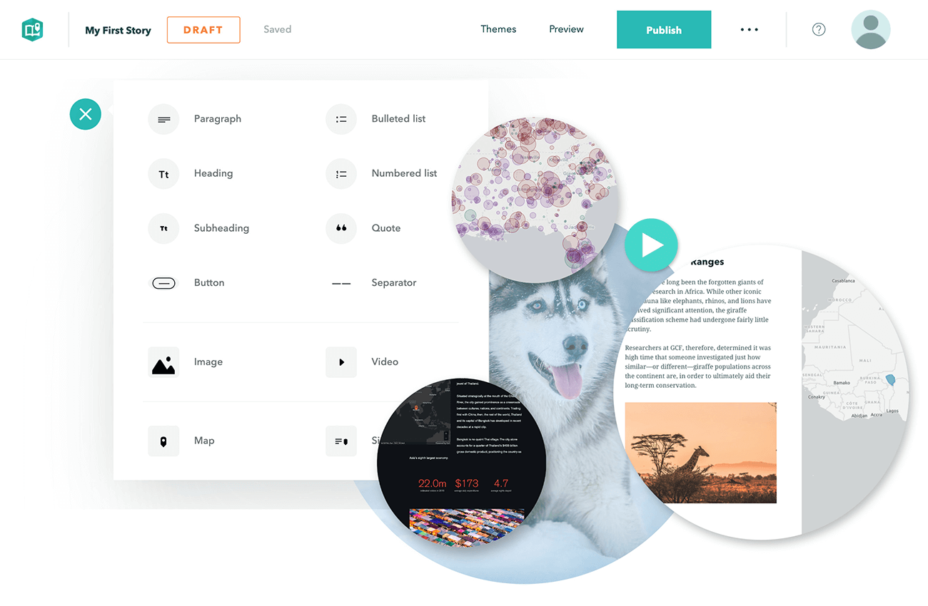
StoryMaps vznikly před sedmi lety jako uživatelsky jednoduchý nástroj na tvorbu vizuálně zajímavých webových prezentací, které kombinují mapy (vytvořené v ArcGIS Online – AGOL) s textem, fotografiemi a videi. Za tu dobu jich uživatelé vytvořili téměř 750 milionů. Nyní Esri představila novou verzi tohoto populárního nástroje, který využívají nejen GIS odborníci, ale i studenti či […]
The post Nové StoryMaps mohou změnit to, jak chápeme webové mapy appeared first on GISportal.cz.
Reálná dopravní data ŘSD pro studentské projekty
16.4.2019 8:02 GeoBusiness Dopravní fakulta Univerzity Pardubice se spojila s Ředitelstvím silnic a dálnic a vysokoškoláci mohou pro své projekty používat aktuální data z informačních systémů ŘSD. Společný ... PřečístSonda BepiColombo je připravena na dlouhou cestu
16.4.2019 8:00 Český Kosmický PortálPo sérii testů provedených přímo ve vesmíru v uplynulých pěti měsících zakončila společná mise ESA a JAXA komisní fázi svého letu a nyní je připravena na operace, které bude provádět během dlouhého přeletu. Následně pak i na průzkum planety Merkur.