


![]()

zprávy
zdroje zpráv:Řízení kvality
5.4.2019 14:34 ČÚZK - volná místa Český úřad zeměměřický a katastrální vypisuje výběrové řízení na místo Řízení kvalityŘízení kvality
5.4.2019 14:34 ČÚZK /Urady/Cesky-urad-zememericky-a-katastralni/Uredni-deska/Oznameni-a-jina-uredni-sdeleni/Volna-mista/Rizeni-kvalityŘízení kvality
5.4.2019 14:34 ČÚZK - předpisy a opatření Český úřad zeměměřický a katastrálnívypisuje výběrové řízení na místo
Řízení kvality
Konference GIS Esri v ČR 2019
5.4.2019 13:23 CENIA - národní geoportál INSPIRE Dovolujeme si Vás pozvat na letošní ročník Konference GIS Esri v ČR, která se v Kongresovém centru Praha uskuteční ve dnech 6. a 7. listopadu 2019. Na konferenci budete mít možnost seznámit se s aktuálními projekty v oboru GIS, příležitost inspirovat se prací kolegů z celé České republiky a v neposlední řadě také uvidíte spoustu technologických novinek, o kterých si budete moci na místě pohovořit...Aeolus well on the way to improving forecasts
5.4.2019 13:00 ESA Observing the Earth
Assessing the accuracy of data being returned by completely new technology in space is a challenging task. But this is exactly what engineers and scientists have been dedicating their time to over the last months so that measurements of the world’s winds being gathered by Aeolus can be fed confidently into weather forecast models.
Možné výpadky provozu DP a WSDP v pátek 5.4.2019 v době od 16:00 do cca 17:00
5.4.2019 12:30 Dálkový přístup k údajům KN ČR Vážení uživatelé,oznamujeme, že v pátek 5.4.2019 v době od 16:00 do 17:00 může z technických důvodů docházet ke krátkodobým výpadkům aplikace.
Za komplikace tímto způsobené se omlouváme a děkujeme za pochopení.
Možné výpadky provozu DP a WSDP v pátek 5.4.2019 v době od 16:00 do cca 17:00
5.4.2019 12:30 ČÚZK /Aplikace-DP-do-KN/Aplikace-DP-do-KN/Archiv-DP/253683Možné výpadky provozu DP a WSDP v pátek 5.4.2019 v době od 16:00 do cca 17:00
5.4.2019 12:30 ČÚZK - předpisy a opatření Vážení uživatelé,oznamujeme, že v pátek 5.4.2019 v době od 16:00 do 17:00 může z technických důvodů docházet ke krátkodobým výpadkům aplikace.
Za komplikace tímto způsobené se omlouváme a děkujeme za pochopení.
Preserving heritage data at ESA
5.4.2019 12:30 ESA Observing the Earth
Why is archiving and curating heritage satellite data so fundamentally important? How can heritage data from old satellites be used to compare with current findings?
Výběrové řízení inspektor/ka - právník (ZKI v Praze)
5.4.2019 12:11 ČÚZK /Urady/Zememericke-a-katastralni-inspektoraty/Zememericke-a-katastralni-inspektoraty/Zememericky-a-katastralni-inspektorat-v-Praze/O-uradu/Aktuality/Vyberove-rizeni-inspektor-ka-pravnik-(ZKI-v-Pr-(1)Výběrové řízení inspektor/ka - právník (ZKI v Praze)
5.4.2019 12:11 ČÚZK - předpisy a opatření Zeměměřický a katastrální inspektorát v Praze zveřejnil novou aktualitu: Oznámení o vyhlášení výběrového řízení na služební místo inspektor/ka – právník Zeměměřického a katastrálního inspektorátu v Praze (obor služby 70.)Inspektor/ka – právník Zeměměřického a katastrálního inspektorátu v Praze
5.4.2019 12:10 ČÚZK /Urady/Zememericke-a-katastralni-inspektoraty/Zememericke-a-katastralni-inspektoraty/Zememericky-a-katastralni-inspektorat-v-Praze/Uredni-deska/Oznameni-a-jina-uredni-sdeleni/Volna-mista/Inspektor-ka-–-pravnik-Zememerickeho-a-katastr-(1)Inspektor/ka – právník Zeměměřického a katastrálního inspektorátu v Praze
5.4.2019 12:10 ČÚZK - předpisy a opatření Zeměměřický a katastrální inspektorát v Prazevypisuje výběrové řízení na místo
Inspektor/ka – právník Zeměměřického a katastrálního inspektorátu v Praze
Inspektor/ka – právník Zeměměřického a katastrálního inspektorátu v Praze
5.4.2019 12:10 ČÚZK - volná místa Zeměměřický a katastrální inspektorát v Praze vypisuje výběrové řízení na místo Inspektor/ka – právník Zeměměřického a katastrálního inspektorátu v PrazeSpace4Rail: From innovation to implementation
5.4.2019 11:19 European GNSS Agency
The first Space for Innovation in Rail conference in Vienna on 18 and 19 March brought together stakeholders from the rail and space sector in a unique event to discuss the important role of satellite-based positioning technology for the future of the European rail sector. The event highlighted a portfolio of research, innovation and deployment projects being funded by the GSA and the Shift2Rail Joint Undertaking that demonstrate how satellite technologies can provide scalable positioning solutions to increase rail safety, boost capacity and efficiency, and deliver global success for advanced European technologies.
In an increasingly digitalised world, the European Global Navigation Satellite Systems Agency (GSA), the European Union Agency for Railways (ERA), and the Shift2Rail Joint Undertaking (S2R JU) are working together to explore the role of satellite technology in future railway systems. Both GSA and S2R JU have a key role in leading innovation and engaging with stakeholders, while ERA orchestrates the process from a regulatory point of view within the framework of the European Railway Traffic Management System (ERTMS).
Over the two days of the Space for Innovation in Rail event in Austria a range of projects looking to integrate satellite technologies with the rail system were presented.
Leading EU rail innovation
The STARS project (Satellite technology for Advanced Railway Signalling) was described by Peter Gurnik of AZD Praha, who was the project coordinator at the start of the project and Jose Bertolin from UNIFE who took over for the later stages. The positioning performance of GNSS is directly affected by environmental conditions that impact on the localisation function and, therefore, the overall performance of a train control system. STARS’ major objective is to fill the technology gap to allow a full implementation of GNSS in safety critical rail applications.
The project has developed a universal method for field measurement and characterisation of the rail environment including a yearlong measurement campaign. “A set of open tools has been developed that can assist rail companies to evaluate identified environmental factors,” said Bertolin. The project also links with economic aspects of GNSS within an enhanced ERTMS.
Massimiliano Ciaffi from Italian rail infrastructure manager RFI said that Italy, a pioneer in adopting ERTMS for high speed lines, has a plan to extend the ERTMS over all lines (about 16 800 km) including regional and local lines for which the ERTMS will likely be the first application in Europe.
The ERSAT (ERTMS on Satellite) initiative started in 2012 is targeting a solution to integrate GNSS positioning and public telecommunications over the ERTMS platform and consists of a portfolio of projects as the pillars of a roadmap to allow RFI a step-wise operational deployment.
The core ERSAT deployment is on the Pinerolo – Sangone line close to Turin that is representative of operational scenarios on regional lines in Italy. “The ERSAT architecture being developed is designed to be upgradable and also backward compatible to allow a fast deployment without prejudging the adoption of the latest satellite technologies,” said Ciaffi. The programme had effectively developed and verified in field satellite technology for ERTMS on a test bed in Sardinia and the objective now is to activate a first commercial line by the end of 2020. Further developments are ongoing to reduce the total cost of ownership and to use the virtual balise concept to achieve a Zero Staff Responsible Time, which will improve safety and efficiency.
Not only signalling
GNSS can also contribute to rail asset management as was demonstrated by the SIA project (System for vehicle- infrastructure Interaction Assets health status monitoring) presented by Wolfgang Zottl of ÖBB-Infrastruktur AG. The initiative is developing four ready-to-use services to provide information about the health status of four of rail’s most demanding assets in terms of maintenance: the wheels, the rails, the overhead pantograph and catenary (power wires). These new services could help to substantially reduce overall railway maintenance costs, unscheduled maintenance and derailments. Location and positioning are important data components for the system.
All four services have some common features being web-based applications using real-time information to make the ‘health assessments’ and able to integrate with current and future operational systems. “Full testing will commence in June this year,” said Zottl. “And will be based on the use of low-cost sensors to provide a cheap system that could be used on all trains.”
EGNOS leverage
A European Space Agency (ESA) funded project STEMS (System Suitability Study for Train Positioning using GNSS in ERTMS) was described by Mike Hutchinson of NSL. The project will examine how to leverage EGNOS for use in the rail sector.
“We will assess the suitability of Satellite-Based Augmentation Systems (SBAS), such as EGNOS, for acceptance by railway authorities,” said Hutchinson. “And propose a methodology for building the safety case for use in ERTMS applications.“
The project will leverage the existing investment and vast experience from the aviation sector and is based on the legacy SBAS configuration of augmenting GPS L1 signals (EGNOS V2 and V3.1).
The X2RAIL2 project aims to refine and develop four selected key technologies in the field of railway signalling and automation systems to the level of technology demonstrators. The four technologies are: Fail-Safe Train Positioning using a multi-sensor concept, where GNSS is one of the preferred technology; On-Board Train Integrity to allow the application of new signalling train separation concepts based on the train self-localisation rather than on traditional train detection systems such as balises; Formal Methods to innovate and standardise processes and interfaces as signalling systems evolve to reduce time-to-market costs; and Traffic Management Evolution that will improve standardisation and integration of Traffic Management processes to achieve flexibility and scalability.
“The project will provide new technical capabilities by combining innovative technologies,” explained Salvatore Sabina of Ansaldo STS. “We are looking to move signal intelligence from trackside to on board the train.”
Next steps
Summing up the project presentations, Daniel Lopour, Market Development Officer at GSA said that “European R&D on GNSS for rail signalling is fully synchronised between GSA, Shift2Rail and ESA.”
Lea Paties, Programme Manager for the Shift2Rail JU agreed that the key element is a high level of coordination to achieve inclusion of GNSS in ERTMS. “We aim at satisfying all the market needs,” she said. “The final system should be stable, fully interoperable, and overall offer reductions in both capital expenditure and operating expenditure for implementation of advanced ERTMS, while improving the flexibility and attractiveness of ERTMS for users in Europe and beyond.”
Lopour outlined some of the next steps to potential wider implementation of a GNSS-based ERTMS. “An analysis of European GNSS performance in the rail segment is available and will feed into a definition of a system architecture within Shift2Rail X2RAIIL2 project,” he said.
There is ongoing work on the cost-benefit of GNSS and further work is required to confirm how appropriate certification for system components might be achieved working with ERA.
Media note: This feature can be republished without charge provided the European GNSS Agency (GSA) is acknowledged as the source at the top or the bottom of the story. You must request permission before you use any of the photographs on the site. If you republish, we would be grateful if you could link back to the GSA website (http://www.gsa.europa.eu).
odborný referent / vrchní referent v oddělení právních vztahů k nemovitostem Katastrálního pracovišt
5.4.2019 10:29 ČÚZK - předpisy a opatření Katastrální úřad pro Pardubický kraj - Katastrální pracoviště Svitavyvypisuje výběrové řízení na místo
odborný referent / vrchní referent v oddělení právních vztahů k nemovitostem Katastrálního pracoviště Svitavy
odborný referent / vrchní referent v oddělení právních vztahů k nemovitostem Katastrálního pracovišt
5.4.2019 10:29 ČÚZK /Urady/Katastralni-urady/Katastralni-urady/Katastralni-urad-pro-Pardubicky-kraj/Uredni-deska/Oznameni-a-jina-uredni-sdeleni/Volna-mista/odborny-referent-vrchni-referent-v-oddeleni-pravodborný referent / vrchní referent v oddělení právních vztahů k nemovitostem Katastrálního pracovišt
5.4.2019 10:29 ČÚZK - volná místa Katastrální úřad pro Pardubický kraj - Katastrální pracoviště Svitavy vypisuje výběrové řízení na místo odborný referent / vrchní referent v oddělení právních vztahů k nemovitostem Katastrálního pracovištBattery Ventures-Backed AED-SICAD Announces Acquisition of GIS Software Company Geocom
5.4.2019 10:26 GISCafe.com Webcasts-Webinars April 4, 2019 -- Munich, Germany -- AED-SICAD, Battery Ventures’ core portfolio company in the geographic-information systems (GIS) …Sdělení pro ÚOZI: Omezení archivního oddělení
5.4.2019 10:19 ČÚZK - předpisy a opatření Katastrální úřad pro hlavní město Prahu - Katastrální pracoviště Praha zveřejnil novou aktualitu: Omezení výdeje nedigitalizovaných dokumentů ZPMZ Sdělení pro ÚOZI:Omezení archivního oddělení
5.4.2019 10:19 ČÚZK - předpisy a opatření Katastrální úřad pro hlavní město Prahu - Katastrální pracoviště Praha zveřejnil novou aktualitu: Omezení výdeje nedigitalizovaných dokumentů ZPMZ Sdělení pro ÚOZI: Vážené kolegyně, vážení kolegové, vzhledem k rekonstrukci archivu ZPMZ Vám nebudeme moci v době od 10. dubna předávat kopie archivních ZPMZ z obvodu působnosti Katastrálního úřadu pro hlavní město Prahu, které jsou doposud pouze v analogové formě. Předpoklad obnovení provozu je začátkem května t.r. Za případné obtíže se Vám omlouváme.Děkujeme za pochopení.
Ing. Lubomír Klučka, ředitel úřadu
Sdělení pro ÚOZI: Omezení archivního oddělení
5.4.2019 10:19 ČÚZK - předpisy a opatření Katastrální úřad pro hlavní město Prahu - Katastrální pracoviště Praha zveřejnil novou aktualitu: Omezení výdeje nedigitalizovaných dokumentů ZPMZ Sdělení pro ÚOZI:Omezení archivního oddělení
5.4.2019 10:19 ČÚZK - předpisy a opatření Katastrální úřad pro hlavní město Prahu - Katastrální pracoviště Praha zveřejnil novou aktualitu: Omezení výdeje nedigitalizovaných dokumentů ZPMZ Vážené kolegyně, vážení kolegové, vzhledem k rekonstrukci archivu ZPMZ Vám nebudeme moci v době od 10. dubna předávat kopie archivních ZPMZ z obvodu působnosti Katastrálního úřadu pro hlavní město Prahu, které jsou doposud pouze v analogové formě. Předpoklad obnovení provozu je začátkem května t.r. Za případné obtíže se Vám omlouváme.Děkujeme za pochopení.
Ing. Lubomír Klučka, ředitel úřadu
Sdělení pro ÚOZI: Omezení archivního oddělení
5.4.2019 10:19 ČÚZK /Urady/Katastralni-urady/Katastralni-urady/Katastralni-urad-pro-hlavni-mesto-Prahu/O-uradu/Aktuality/Omezeni-archivniho-oddeleniOmezení archivního oddělení
5.4.2019 10:19 ČÚZK - předpisy a opatření Katastrální úřad pro hlavní město Prahu - Katastrální pracoviště Praha zveřejnil novou aktualitu: Omezení výdeje nedigitalizovaných dokumentů ZPMZ Sdělení pro ÚOZI:Omezení archivního oddělení
5.4.2019 10:19 ČÚZK - předpisy a opatření Katastrální úřad pro hlavní město Prahu - Katastrální pracoviště Praha zveřejnil novou aktualitu: Omezení výdeje nedigitalizovaných dokumentů ZPMZ Sdělení pro ÚOZI: Vážené kolegyně, vážení kolegové, vzhledem k rekonstrukci archivu ZPMZ Vám nebudeme moci v době od 10. dubna předávat kopie archivních ZPMZ z obvodu působnosti Katastrálního úřadu pro hlavní město Prahu, které jsou doposud pouze v analogové formě. Předpoklad obnovení provozu je začátkem května t.r. Za případné obtíže se Vám omlouváme.Děkujeme za pochopení.
Ing. Lubomír Klučka, ředitel úřadu
Omezení archivního oddělení
5.4.2019 10:19 ČÚZK /Urady/Katastralni-urady/Katastralni-urady/Katastralni-urad-pro-hlavni-mesto-Prahu/O-uradu/Aktuality/Omezeni-archivniho-oddeleniAssetWorks Launches Fleet Benchmarking Tool Powered by Utilimarc
5.4.2019 10:15 GISCafe.com Webcasts-Webinars FleetMetrics, powered by Utilimarc, is a benchmarking tool designed to help understand a government fleet’s performance and identify areas for …Egyptian crop circles
5.4.2019 10:05 ESA Observing the Earth
Earth observation image of the week: this long-time series shows the development over 21 years of an important land reclamation project in the Western Desert of Egypt
Earth from Space
5.4.2019 10:05 ESA Observing the Earth
In this week's edition, we take a look at the agricultural development in the Western Desert of Egypt
Více hodin korekcí Trimble VRS Now
5.4.2019 10:01 Geotronics GEODÉZIE - Objednejte korekce Czech Unlimited nebo Czech 100 do konce dubna a měřte déle s hodinami navíc.Více hodin korekcí Trimble VRS Now
5.4.2019 10:01 Geotronics GEODÉZIE - Objednejte korekce Czech Unlimited a Czech 100 do konce dubna a měřte déle s hodinami navíc.New Version of the Global Mapper SDK Now Available with Support for S-52 Marine Chart Symbology and LiDAR Point Selection by Proximity
5.4.2019 9:48 GISCafe.com Webcasts-Webinars Hallowell, Maine – April 4, 2019 - Blue Marble Geographics (bluemarblegeo.com) is pleased to announce that a new version of the Global Mapper …Blue Marble Announces 2018-19 Academic Scholarship Winner and Unveils Scholarship Program for 2019-20 School Year
5.4.2019 9:34 GISCafe.com Webcasts-Webinars Hallowell, Maine – April 2, 2019 - Blue Marble Geographics (bluemarblegeo.com) is pleased to announce the winner of the 2018-2019 Academic …Výroční zpráva dle zákona č. 106/1999 Sb. za rok 2018
5.4.2019 9:11 Zeměměřický úřad Zeměměřický úřadvydává výroční zprávu úřadu za rok
2018
Výroční zpráva dle zákona č. 106/1999 Sb. za rok 2018
5.4.2019 9:11 ČÚZK - předpisy a opatření Zeměměřický úřadvydává výroční zprávu úřadu za rok
2018
Výroční zpráva dle zákona č. 106/1999 Sb. za rok 2018
5.4.2019 9:11 ČÚZK /Urady/Zememericky-urad/Dalsi-informace/UAZK/Vyrocni-zprava-UAZK/Vyrocni-zprava-dle-zakona-c-106-1999-Sb-za-rok-2Space tech set to help combat cocoa-fuelled deforestation
5.4.2019 9:00 GISCafe.com Webcasts-Webinars UK Space Agency’s pioneering Forests 2020 Project enables cocoa buyers to plot supply chain data onto satellite and LiDAR mapEdinburgh, 3 …
Odborný referent/vrchní referent – zápisy v řízení V a Z na Katastrálním pracovišti Ostrava Katastrá
5.4.2019 8:49 ČÚZK - předpisy a opatření Katastrální úřad pro Moravskoslezský kraj - Katastrální pracoviště Ostravavypisuje výběrové řízení na místo
Odborný referent/vrchní referent – zápisy v řízení V a Z na Katastrálním pracovišti Ostrava Katastrálního úřadu pro Moravskoslezský kraj
Odborný referent/vrchní referent – zápisy v řízení V a Z na Katastrálním pracovišti Ostrava Katastrá
5.4.2019 8:49 ČÚZK /Urady/Katastralni-urady/Katastralni-urady/Katastralni-urad-pro-Moravskoslezsky-kraj/Uredni-deska/Oznameni-a-jina-uredni-sdeleni/Volna-mista/Odborny-referent-vrchni-referent-–-zapisy-v-ri-(1)Odborný referent/vrchní referent – zápisy v řízení V a Z na Katastrálním pracovišti Ostrava Katastrá
5.4.2019 8:49 ČÚZK - volná místa Katastrální úřad pro Moravskoslezský kraj - Katastrální pracoviště Ostrava vypisuje výběrové řízení na místo Odborný referent/vrchní referent – zápisy v řízení V a Z na Katastrálním pracovišti Ostrava KatastráOdborný referent/vrchní referent – obnova katastrálního operátu v technickém odboru 385 Katastrálníh
5.4.2019 8:47 ČÚZK - volná místa Katastrální úřad pro Moravskoslezský kraj - technický odbor vypisuje výběrové řízení na místo Odborný referent/vrchní referent – obnova katastrálního operátu v technickém odboru 385 KatastrálníhOdborný referent/vrchní referent – obnova katastrálního operátu v technickém odboru 385 Katastrálníh
5.4.2019 8:47 ČÚZK - předpisy a opatření Katastrální úřad pro Moravskoslezský kraj - technický odborvypisuje výběrové řízení na místo
Odborný referent/vrchní referent – obnova katastrálního operátu v technickém odboru 385 Katastrálního úřadu pro Moravskoslezský kraj
Odborný referent/vrchní referent – obnova katastrálního operátu v technickém odboru 385 Katastrálníh
5.4.2019 8:47 ČÚZK /Urady/Katastralni-urady/Katastralni-urady/Katastralni-urad-pro-Moravskoslezsky-kraj/Uredni-deska/Oznameni-a-jina-uredni-sdeleni/Volna-mista/Odborny-referent-vrchni-referent-–-obnova-kata-(1)Odborný referent/vrchní referent – zápisy v řízení V a Z na Katastrálním pracovišti Frýdek-Místek Ka
5.4.2019 8:43 ČÚZK - volná místa Katastrální úřad pro Moravskoslezský kraj - Katastrální pracoviště Frýdek-Místek vypisuje výběrové řízení na místo Odborný referent/vrchní referent – zápisy v řízení V a Z na Katastrálním pracovišti Frýdek-Místek KaOdborný referent/vrchní referent – zápisy v řízení V a Z na Katastrálním pracovišti Frýdek-Místek Ka
5.4.2019 8:43 ČÚZK - předpisy a opatření Katastrální úřad pro Moravskoslezský kraj - Katastrální pracoviště Frýdek-Místekvypisuje výběrové řízení na místo
Odborný referent/vrchní referent – zápisy v řízení V a Z na Katastrálním pracovišti Frýdek-Místek Katastrálního úřadu pro Moravskoslezský kraj
Odborný referent/vrchní referent – zápisy v řízení V a Z na Katastrálním pracovišti Frýdek-Místek Ka
5.4.2019 8:43 ČÚZK /Urady/Katastralni-urady/Katastralni-urady/Katastralni-urad-pro-Moravskoslezsky-kraj/Uredni-deska/Oznameni-a-jina-uredni-sdeleni/Volna-mista/Odborny-referent-vrchni-referent-–-zapisy-v-rizeniOdborný referent/vrchní referent – obnova katastrálního operátu v technickém odboru 40 Katastrálního
5.4.2019 8:39 ČÚZK - předpisy a opatření Katastrální úřad pro Moravskoslezský kraj - technický odborvypisuje výběrové řízení na místo
Odborný referent/vrchní referent – obnova katastrálního operátu v technickém odboru 40 Katastrálního úřadu pro Moravskoslezský kraj
Odborný referent/vrchní referent – obnova katastrálního operátu v technickém odboru 40 Katastrálního
5.4.2019 8:39 ČÚZK /Urady/Katastralni-urady/Katastralni-urady/Katastralni-urad-pro-Moravskoslezsky-kraj/Uredni-deska/Oznameni-a-jina-uredni-sdeleni/Volna-mista/Odborny-referent-vrchni-referent-–-obnova-katastraOdborný referent/vrchní referent – obnova katastrálního operátu v technickém odboru 40 Katastrálního
5.4.2019 8:39 ČÚZK - volná místa Katastrální úřad pro Moravskoslezský kraj - technický odbor vypisuje výběrové řízení na místo Odborný referent/vrchní referent – obnova katastrálního operátu v technickém odboru 40 KatastrálníhoVrchní referent/rada – obnova katastrálního operátu v technickém odboru 71 Katastrálního úřadu pro M
5.4.2019 8:37 ČÚZK - předpisy a opatření Katastrální úřad pro Moravskoslezský kraj - technický odborvypisuje výběrové řízení na místo
Vrchní referent/rada – obnova katastrálního operátu v technickém odboru 71 Katastrálního úřadu pro Moravskoslezský kraj
Vrchní referent/rada – obnova katastrálního operátu v technickém odboru 71 Katastrálního úřadu pro M
5.4.2019 8:37 ČÚZK /Urady/Katastralni-urady/Katastralni-urady/Katastralni-urad-pro-Moravskoslezsky-kraj/Uredni-deska/Oznameni-a-jina-uredni-sdeleni/Volna-mista/Vrchni-referent-rada-–-obnova-katastralniho-op-(1)Vrchní referent/rada – obnova katastrálního operátu v technickém odboru 71 Katastrálního úřadu pro M
5.4.2019 8:37 ČÚZK - volná místa Katastrální úřad pro Moravskoslezský kraj - technický odbor vypisuje výběrové řízení na místo Vrchní referent/rada – obnova katastrálního operátu v technickém odboru 71 Katastrálního úřadu pro MOdborný referent – obnova katastrálního operátu v technickém odboru 59 Katastrálního úřadu pro Morav
5.4.2019 8:34 ČÚZK - volná místa Katastrální úřad pro Moravskoslezský kraj - technický odbor vypisuje výběrové řízení na místo Odborný referent – obnova katastrálního operátu v technickém odboru 59 Katastrálního úřadu pro MoravOdborný referent – obnova katastrálního operátu v technickém odboru 59 Katastrálního úřadu pro Morav
5.4.2019 8:34 ČÚZK - předpisy a opatření Katastrální úřad pro Moravskoslezský kraj - technický odborvypisuje výběrové řízení na místo
Odborný referent – obnova katastrálního operátu v technickém odboru 59 Katastrálního úřadu pro Moravskoslezský kraj
Odborný referent – obnova katastrálního operátu v technickém odboru 59 Katastrálního úřadu pro Morav
5.4.2019 8:34 ČÚZK /Urady/Katastralni-urady/Katastralni-urady/Katastralni-urad-pro-Moravskoslezsky-kraj/Uredni-deska/Oznameni-a-jina-uredni-sdeleni/Volna-mista/Odborny-referent-–-obnova-katastralniho-operatu-vVrchní referent/rada – obnova katastrálního operátu v technickém odboru 52 Katastrálního úřadu pro M
5.4.2019 8:32 ČÚZK - předpisy a opatření Katastrální úřad pro Moravskoslezský kraj - technický odborvypisuje výběrové řízení na místo
Vrchní referent/rada – obnova katastrálního operátu v technickém odboru 52 Katastrálního úřadu pro Moravskoslezský kraj
Vrchní referent/rada – obnova katastrálního operátu v technickém odboru 52 Katastrálního úřadu pro M
5.4.2019 8:32 ČÚZK /Urady/Katastralni-urady/Katastralni-urady/Katastralni-urad-pro-Moravskoslezsky-kraj/Uredni-deska/Oznameni-a-jina-uredni-sdeleni/Volna-mista/Vrchni-referent-rada-–-obnova-katastralniho-operatVrchní referent/rada – obnova katastrálního operátu v technickém odboru 52 Katastrálního úřadu pro M
5.4.2019 8:32 ČÚZK - volná místa Katastrální úřad pro Moravskoslezský kraj - technický odbor vypisuje výběrové řízení na místo Vrchní referent/rada – obnova katastrálního operátu v technickém odboru 52 Katastrálního úřadu pro M„Kosmická“ mobilní laboratoř je připravena na nouzové situace
5.4.2019 8:22 Český Kosmický PortálLaboratoř, která dovoluje záchranářům prvního sledu rychle a bezpečně bojovat s biologickým nebezpečím nebo infekčními nemocemi, prokázala své kvality během simulovaného biologického incidentu. Cvičení proběhlo v Belgii.
The Oak Ridge Boys Will Perform at the 2019 Carlson User Conference
4.4.2019 23:26 Carlson Software MAYSVILLE, Kentucky, U.S.A. (April 2019) — Carlson Software is proud to announce that the acclaimed Oak Ridge Boys, Country Music Hall of Fame and Grand Ole Opry members and Grammy winners, will be appearing at Carlson’s International User Conference on Tuesday, May 7th. The concert will be held at the Washington Opera House, located at […]Radius boosts vehicle tracking division with acquisition of Plant-i
4.4.2019 16:58 GISCafe.com Webcasts-Webinars April 04, 2019 -- Radius Payment Solutions, the group behind the telematics and fuel card brands Kinesis and UK Fuels, has acquired Plant-i, the …HawkEye 360 Launches First Commercial Product - RFGeo
4.4.2019 16:57 GISCafe.com Webcasts-Webinars Radio frequency (RF) signal mapping reveals new patterns of lifeHERNDON, Va., April 4, 2019 — (PRNewswire) — HawkEye 360 Inc. today …
Mapová aplikace ÚAP - aktualizace
4.4.2019 14:55 Jihočeský kraj Mapová aplikace Územně analytické podklady byla aktualizována k 3.4.2019.Preserving data
4.4.2019 14:28 ESA Observing the Earth
Through its Heritage Data Programme, ESA ensures the preservation and access to Earth observation satellite data for now and the future
University of Toronto Map and Data Library
4.4.2019 13:42 The University of Toronto Map and Data Library is hiring a Reference Specialist (permanent full-time). Please see the following posting and application information in the link below. Please forward to anyone you feel may be interested in applying. For further information, please contact me directly at marcel.fortin@utoronto.ca. https://utoronto.taleo.net/careersection/10000/jobdetail.ftl?job=1900674&tz=GMT-04%3A00Vrchní referent / rada v oddělení dokumentace KN na Katastrálním pracovišti Vyškov
4.4.2019 13:16 ČÚZK /Urady/Katastralni-urady/Katastralni-urady/Katastralni-urad-pro-Jihomoravsky-kraj/Uredni-deska/Oznameni-a-jina-uredni-sdeleni/Volna-mista/Vrchni-referent-rada-v-oddeleni-dokumentace-KN-nVrchní referent / rada v oddělení dokumentace KN na Katastrálním pracovišti Vyškov
4.4.2019 13:16 ČÚZK - volná místa Katastrální úřad pro Jihomoravský kraj - Katastrální pracoviště Vyškov vypisuje výběrové řízení na místo Vrchní referent / rada v oddělení dokumentace KN na Katastrálním pracovišti VyškovVrchní referent / rada v oddělení dokumentace KN na Katastrálním pracovišti Vyškov
4.4.2019 13:16 ČÚZK - předpisy a opatření Katastrální úřad pro Jihomoravský kraj - Katastrální pracoviště Vyškovvypisuje výběrové řízení na místo
Vrchní referent / rada v oddělení dokumentace KN na Katastrálním pracovišti Vyškov
OGC invites developers to the OGC API Hackathon
4.4.2019 12:09 GISCafe.com Webcasts-Webinars Participate in the most important hackathon in OGC history!3 April 2019: The Open Geospatial Consortium (OGC) invites interested developers to the …
ESA a Barbie ukazují cestu ke hvězdám
4.4.2019 11:52 Český Kosmický PortálNejznámější panenka na světě, Barbie, nedávno oslavila své šedesátiny. V upomínku na toto výročí spojila Barbie své síly s ESA a vznikly tak dvě zcela jedinečné panenky mající podobu astronautky ESA Samanthy Cristoforettiové.
GNSS year in review at the Munich Satellite Navigation Summit
4.4.2019 11:48 European GNSS Agency Mattias Petschke, Jan Woerner, Pascale Ehrenfreund, Jia Peng, Carlo des Dorides, David Comby and Oleg Kem, with moderator Claus Kruesken at the opening plenary.")
The opening plenary of the Munich Satellite Navigation Summit, on March 25, provided an opportunity for representatives from the GNSS industry in Europe and around the world to look back on what has been achieved in the year since the last summit, and to look to the future, where the challenge is to maintain current high levels of performance.
The theme of this year’s summit was ‘Augment yourself with GNSS’ and the opening session looked at how innovations in GNSS, combined with international cooperation, are bringing benefits to society. While highlighting the critical value of Galileo accuracy, Dr Thomas Pany from the Institute of Space Technology and Space Applications at Bundeswehr University Munich said that all the global and regional satellite navigation systems would have to work closely together to reap the maximum innovative benefits of GNSS.
Matthias Petschke, Director for the EU Satellite Navigation Programmes at the European Commission’s Directorate-General for the Internal Market, Industry, Entrepreneurship and SMEs, noted significant achievements over the past year, with more satellites launched and brought into operation, and important contracts signed, particularly for the ground segment.
Galileo market uptake
Petschke said, however, that these major achievements sometimes overshadow more ‘minor’ achievements that deserve to be put in the spotlight. Among these, he listed a waiver, in November 2018, from the U.S. Federal Communications Commission (FCC) for the use of Galileo signals in the U.S., and the publication of the E112 Delegated Regulation in December, requiring all smartphones sold in the EU to be ‘at least Galileo-enabled’ by March 2022, as two achievements that would promote the increased uptake of Galileo both in Europe and internationally.
Read this: GNSS chip manufacturers gear up for Galileo roll-out in U.S.
“Galileo is vital for Europe’s critical infrastructure,” said Dr Pascale Ehrenfreund, Chair of the Executive Board of DLR, adding that as the system nears full operational capability there has been a shift in focus from infrastructure to service delivery to end users.
In his address at the Summit, European GNSS Agency (GSA) Executive Director Carlo des Dorides also highlighted the major success in terms of service delivery and market uptake over the past 12 months, with almost 700 million Galileo users worldwide. “This is a remarkable result, which is being reinforced by the introduction to the market of dual frequency chipsets and the first smartphones exploiting this double frequency capability, bringing better accuracy and a more robust signal,” he said, reminding that the Galileo constellation has the highest number of dual-frequency satellites of any GNSS system.
Excellent performance
Des Dorides also referenced the recent launch of a Galileo-enabled chip with very low power consumption. “This is ideally suited for the IoT and we expect to see Galileo reaching very high uptake in this interesting domain also,” he said.
Participants in the panel highlighted the excellent level of Galileo’s performance. “A report published by the Galileo Reference Centre, working closely with relevant entities at the level of Member States, shows that we are surpassing by far all of our commitments in terms of performance,” Petschke said.
Des Dorides concurred, noting that Galileo’s performance had been excellent, with horizontal positioning accuracy well below 1.5 metres and per slot availability approaching 99.5%. “The challenge ahead is to maintain this level of excellence,” he said.
Huge steps for EGNOS
EGNOS too has seen some major developments. In particular, Petschke noted the adoption last year of a performance-based navigation implementing rule, which makes compulsory the publication of EGNOS-based procedures in all EU airports before January 2024. “This is a huge step for the uptake of EGNOS in aviation,” he said.
And this: Galileo is key to Europe's digital economy
What’s more, in March 2019 the EGNOS Service Definition Document was updated with Safety of Life coverage extended to 72° N, providing full coverage in northern Scandinavia, and a new EGNOS transponder is set to be launched in May or June this year. “This will ensure continuity of EGNOS service provision over the next decade, at least,” Petschke said.
Des Dorides noted that EGNOS was well deployed over Europe, with more than 300 airports or helipads served. “Other domains, such as the maritime and rail sectors, are also coming on-board,” he said.
Summing up, des Dorides cited the State of the Union address by Jean-Claude Junker, in which the European Commission president highlighted that Galileo’s success is Europe’s success. “Galileo is finding its place as one of the most important achievements of the European Union,” des Dorides said.
GNSS year in review at the Munich Satellite Navigation Summit
4.4.2019 11:48 European GNSS AgencyThe opening plenary of the Munich Satellite Navigation Summit, on March 25, provided an opportunity for representatives from the GNSS industry in Europe and around the world to look back on what has been achieved in the year since the last summit, and to look to the future, where the challenge is to maintain current high levels of performance.
The theme of this year’s summit was ‘Augment yourself with GNSS’ and the opening session looked at how innovations in GNSS, combined with international cooperation, are bringing benefits to society. While highlighting the critical value of Galileo accuracy, Dr Thomas Pany from the Institute of Space Technology and Space Applications at Bundeswehr University Munich said that all the global and regional satellite navigation systems would have to work closely together to reap the maximum innovative benefits of GNSS.
Matthias Petschke, Director for the EU Satellite Navigation Programmes at the European Commission’s Directorate-General for the Internal Market, Industry, Entrepreneurship and SMEs, noted significant achievements over the past year, with more satellites launched and brought into operation, and important contracts signed, particularly for the ground segment.
Galileo market uptake
Petschke said, however, that these major achievements sometimes overshadow more ‘minor’ achievements that deserve to be put in the spotlight. Among these, he listed a waiver, in November 2018, from the U.S. Federal Communications Commission (FCC) for the use of Galileo signals in the U.S., and the publication of the E112 Delegated Regulation in December, requiring all smartphones sold in the EU to be ‘at least Galileo-enabled’ by March 2022, as two achievements that would promote the increased uptake of Galileo both in Europe and internationally.
Read this: GNSS chip manufacturers gear up for Galileo roll-out in U.S.
“Galileo is vital for Europe’s critical infrastructure,” said Dr Pascale Ehrenfreund, Chair of the Executive Board of DLR, adding that as the system nears full operational capability there has been a shift in focus from infrastructure to service delivery to end users.
In his address at the Summit, European GNSS Agency (GSA) Executive Director Carlo des Dorides also highlighted the major success in terms of service delivery and market uptake over the past 12 months, with almost 700 million Galileo users worldwide. “This is a remarkable result, which is being reinforced by the introduction to the market of dual frequency chipsets and the first smartphones exploiting this double frequency capability, bringing better accuracy and a more robust signal,” he said, reminding that the Galileo constellation has the highest number of dual-frequency satellites of any GNSS system.
Excellent performance
Des Dorides also referenced the recent launch of a Galileo-enabled chip with very low power consumption. “This is ideally suited for the IoT and we expect to see Galileo reaching very high uptake in this interesting domain also,” he said.
Participants in the panel highlighted the excellent level of Galileo’s performance. “A report published by the Galileo Reference Centre, working closely with relevant entities at the level of Member States, shows that we are surpassing by far all of our commitments in terms of performance,” Petschke said.
Des Dorides concurred, noting that Galileo’s performance had been excellent, with horizontal positioning accuracy well below 1.5 metres and per slot availability approaching 99.5%. “The challenge ahead is to maintain this level of excellence,” he said.
Huge steps for EGNOS
EGNOS too has seen some major developments. In particular, Petschke noted the adoption last year of a performance-based navigation implementing rule, which makes compulsory the publication of EGNOS-based procedures in all EU airports before January 2024. “This is a huge step for the uptake of EGNOS in aviation,” he said.
And this: Galileo is key to Europe's digital economy
What’s more, in March 2019 the EGNOS Service Definition Document was updated with Safety of Life coverage extended to 72° N, providing full coverage in northern Scandinavia, and a new EGNOS transponder is set to be launched in May or June this year. “This will ensure continuity of EGNOS service provision over the next decade, at least,” Petschke said.
Des Dorides noted that EGNOS was well deployed over Europe, with more than 300 airports or helipads served. “Other domains, such as the maritime and rail sectors, are also coming on-board,” he said.
Summing up, des Dorides cited the State of the Union address by Jean-Claude Junker, in which the European Commission president highlighted that Galileo’s success is Europe’s success. “Galileo is finding its place as one of the most important achievements of the European Union,” des Dorides said.
World's only open-source industrial-grade environmental sensing and asset tracking solution with cellular connectivity, energy harvesting, GPS, and NFC
4.4.2019 10:59 GISCafe.com Webcasts-Webinars Developed by Finnish open-source electronicsspecialist, Ruuvi Innovations, the Ruuvi Node is said to be a highly robust, maintenance-free, 100 per …CartoVista Creates Thematic Map With Brewery and Beer Data for National Beer Day
4.4.2019 10:42 GISCafe.com Webcasts-Webinars Map buffs are encouraged to explore the map to win a $50 eGift card from CraftShack.com (Contest closes April 8th, 2019)April 04, 2019 -- With …
Vyhlášení termínu Konference GIS Esri v ČR 2019
4.4.2019 10:30 ARCDATANa konferenci budete mít možnost seznámit se s aktuálními projekty v oboru GIS, příležitost inspirovat se prací kolegů z celé České republiky a v neposlední řadě také uvidíte spoustu technologických novinek, o kterých si budete moci na místě pohovořit s našimi konzultanty, nebo si je dokonce rovnou i vyzkoušet.
Rezervujete si proto čas a připojte se k bezmála tisícovce odborníků, kteří se na této konferenci pravidelně scházejí. Více informací naleznete na webové stránce konference.

Exprodat Awarded Esri’s “Release Ready Speciality”
4.4.2019 9:00 GISCafe.com Webcasts-Webinars April 03, 2019 -- Exprodat, the petroleum ArcGIS platform specialist, Esri Gold-level Partner and Getech Group company, has been awarded the Release …Odborný referent/vrchní referent – obnova katastrálního operátu OKO0322
4.4.2019 8:51 ČÚZK - volná místa Katastrální úřad pro Plzeňský kraj - odbor obnovy katastrálního operátu vypisuje výběrové řízení na místo Odborný referent/vrchní referent – obnova katastrálního operátu OKO0322Odborný referent/vrchní referent – obnova katastrálního operátu OKO0322
4.4.2019 8:51 ČÚZK - předpisy a opatření Katastrální úřad pro Plzeňský kraj - odbor obnovy katastrálního operátuvypisuje výběrové řízení na místo
Odborný referent/vrchní referent – obnova katastrálního operátu OKO0322
Odborný referent/vrchní referent – obnova katastrálního operátu OKO0322
4.4.2019 8:51 ČÚZK /Urady/Katastralni-urady/Katastralni-urady/Katastralni-urad-pro-Plzensky-kraj/Uredni-deska/Oznameni-a-jina-uredni-sdeleni/Volna-mista/Odborny-referent-vrchni-referent-–-obnova-kata-(1)Global Commercial and Military Flight Simulation Industry
4.4.2019 0:22 GISCafe.com Webcasts-Webinars NEW YORK, April 3, 2019 — (PRNewswire) — This report analyzes the worldwide markets for Commercial and Military Flight Simulation in US$ …Cape Analytics Unveils Defensible Space Intelligence for Wildfire Risk
3.4.2019 22:30 GISCafe.com Webcasts-Webinars Company uses AI and geospatial imagery to provide wildfire-relatedproperty information to insurers, reinsurers, and CAT risk providers
…
Geospatial World Forum 2019 kick starts in Amsterdam
3.4.2019 22:28 GISCafe.com Webcasts-Webinars 2 April 2019, Amsterdam: Geospatial World Forum (GWF) 2019, the most anticipated event for the global geospatial community, commenced yesterday at …VRMesh V10.3 Provides Water Catchment Analysis
3.4.2019 17:38 GISCafe.com Webcasts-Webinars Apr. 3rd, 2019 - VirtualGrid is pleased to announce the availability of VRMesh v10.3, the latest version of its powerful point cloud and mesh …Trimble Expands CenterPoint RTX Fast Correction Service in North America
3.4.2019 17:36 GISCafe.com Webcasts-Webinars Trimble Doubles Coverage Area of its 2018 North American Network FootprintSUNNYVALE, Calif., April 3, 2019 — (PRNewswire) — …
Maxar Technologies Partners with Vulcan Inc. to Support Domain Awareness Systems Using EarthWatch
3.4.2019 17:36 GISCafe.com Webcasts-Webinars WESTMINSTER, CO, April 3, 2019 — (PRNewswire) — Maxar Technologies (NYSE: MAXR) (TSX: MAXR), a global technology innovator …Velodyne Lidar Announced as Finalist for AUVSI XCELLENCE Awards
3.4.2019 17:36 GISCafe.com Webcasts-Webinars Velodyne Alpha Puck™ Recognized for Providing Rich ComputerPerception Data in Mobile Mapping Applications
SAN JOSE, Calif. — …
ReconaSense Introduces Geospatial A.I. to Help Organizations Visualize Their Security Posture
3.4.2019 17:36 GISCafe.com Webcasts-Webinars Real-time location and security intelligence expedites safetymeasures to proactively mitigate the risk and impact of environmental
…
Skyfire and Darley to Give Away Another Drone Program
3.4.2019 17:36 GISCafe.com Webcasts-Webinars ATLANTA, April 3, 2019 — (PRNewswire) — Skyfire, the nation's leading public safety UAS consultancy, is partnering with equipment …Copernicus Masters 2019 submissions open
3.4.2019 15:36 ESA Observing the Earth
The Copernicus Masters 2019 competition is now open for submissions. This international competition awards prizes to innovative solutions, developments and ideas for business and society that use Copernicus data.
Vyhlášení platnosti - pozemková úprava
3.4.2019 14:59 ČÚZK /Urady/Katastralni-urady/Katastralni-urady/Katastralni-urad-pro-Liberecky-kraj/Katastralni-pracoviste/KP-Ceska-Lipa/O-uradu/Aktuality/Vyhlaseni-platnosti-pozemkova-upravaVyhlášení platnosti - pozemková úprava
3.4.2019 14:59 ČÚZK - předpisy a opatření Katastrální úřad pro Liberecký kraj - Katastrální pracoviště Česká Lípazveřejnil novou aktualitu: Katastrální úřad pro Liberecký kraj, Katastrální pracoviště Česká Lípa oznamuje, že dne 1. 4. 2019, vyhlásil s účinností k 25. 2. 2019, platnost obnoveného katastrálního operátu na podkladě výsledků pozemkových úprav v částech katastrálního území Pavlovice u Jestřebí, Drchlava, Dřevčice a Šváby. Podrobnosti viz úřední deska sp. zn. PUP-3/2014-501.
20190403 - Dvoufaktorová autentizace v ISÚI
3.4.2019 13:47 ČÚZK - předpisy a opatření Změna přihlašování do ISÚI:Od 28. 5. 2019 bude možné přihlášení do ISÚI buď osobním komerčním certifikátem nebo OTP (one time password). Po tomto termínu nebude možné přihlášení pouze jménem a heslem. Důvodem je termín účinnosti vyhlášky č. 82/2018 Sb., (vyhláška o kybernetické bezpečnosti), § 19 odst. 3.
Příručky pro nastavení certifikátu (Příručka pro běžného uživatele, Příručka pro lokálního administrátora) nebo OTP (Příručka pro OTP přihlašování) naleznete na adrese https://www.czechpoint.cz/dokumentace/prirucky/.
Děkujeme za pochopení.
Zveřejněno 3. 4. 2019
20190403 - Dvoufaktorová autentizace v ISÚI
3.4.2019 13:47 ČÚZK /Uvod/Produkty-a-sluzby/RUIAN/RUIAN-novinky/2019/20190403-Dvoufaktorova-autentizace-v-ISUIKonference HxGN LOCAL ČESKO A SLOVENSKO 2019
3.4.2019 13:01 CENIA - národní geoportál INSPIRE One Hexagon - Safety & Infrastructure, Geospatial, Manufacturing Intelligence a PPM pořádají 2. ročník společné uživatelské konference, během které vám představí novinky a zajímavosti z oblasti 3D měření, skenování, softwarových a hardwarových řešení a mobilních aplikací. Letošní ročník se bude konat ve dnech 19.-20. června v krásném prostředí zámeckého hotelu Valeč uprostřed Českomoravské...Orbit Logic Delivers Scheduling Software to NOAA to Optimize Search & Rescue Coverage
3.4.2019 12:16 GISCafe.com Webcasts-Webinars GREENBELT, MD (April 2nd, 2019) – Orbit Logic announced today that it has delivered scheduling software to the National Oceanographic and …RIEGL to Attend and Exhibit at Automate 2019!
3.4.2019 11:24 GISCafe.com Webcasts-Webinars RIEGL will be attending and exhibiting at Automate 2019!Automate 2019 will take place from April 8th-11th, 2019, at McCormick Place in Chicago, …
Dozens of Government Leaders to Present on the GEOINT 2019 Government Pavilion Stage
3.4.2019 11:16 GISCafe.com Webcasts-Webinars Federal experts will discuss current programs and business opportunitiesHerndon, Virginia (April 2, 2019) — Those seeking insight into some …
OGC Invites you to Participate in its combined Disasters Resilience 2019 & GEOSS Architecture Implementation Pilot
3.4.2019 11:08 GISCafe.com Webcasts-Webinars The initiative seeks to develop best practices in sharing and accessing data through Spatial Data Infrastructures in specific contexts, with Disaster …Aktualizace průběhu turistických tras a cyklotras
3.4.2019 10:55 Plzeňský kraj Byl aktualizován tematický obsah interaktivní mapy zobrazující Turistické trasy a cyklotrasy v Plzeňském kraji.Aktualizace dat ÚAP poskytovatelů E.ON Distribuce, GasNet, České radiokomunikace
3.4.2019 10:45 Plzeňský kraj V datech územně analytických podkladů Plzeňského kraje byla provedena kompletní aktualizace dat ve správě poskytovatelů E.ON Distribuce, a.s., GasNet, s.r.o. a České radiokomunikace a.s.Konference HxGN LOCAL ČESKO A SLOVENSKO 2019
3.4.2019 10:09 CENIA - národní geoportál INSPIRE One Hexagon - Safety & Infrastructure, Geospatial, Manufacturing Intelligence a PPM pořádají 2. ročník společné uživatelské konference, během které vám představí novinky a zajímavosti z oblasti 3D měření, skenování, softwarových a hardwarových řešení a mobilních aplikací. Letošní ročník se bude konat ve dnech 19.-20. června v krásném prostředí zámeckého hotelu Valeč uprostřed Českomoravské...NavPro takes top prize @ Galileo Hackathon by GNSS.asia
3.4.2019 9:49 European GNSS Agency
The NavPro team took the top prize at the Galileo Hackathon by H2020 project GNSS.asia, with their Rail Unfail solution, a GNSS-based maintenance system that geotags potential fault locations on railway tracks.
Over 80 programmers from universities and enterprises all over India came together at PES University, Bangalore on 16-17 March to form 20 teams in the Galileo Hackathon by GNSS.asia. Following an intensive morning of technical and business-focused training sessions, the teams worked through the night, leveraging Galileo in applications to support smart cities, smart mobility, health or vulnerable citizens.
Read this: Bavaria rings to the sound of BELS+
The challenge was to develop either a user-friendly, fast and cost-efficient turnkey transport solution for Bangalore; a smart city solution for citizens who are disadvantaged and/or have health issues, or that increases the safety of vulnerable population groups; or other smart solutions for Bangalore, India or globally, using Galileo.
Worthy winners
NavPro’s winning idea won over the jury with its innovative application to tackle India’s railway safety challenges, using Galileo to accurately and proactively geotag potential fault locations on railway tracks. Second prize went to the Phoenix team from Vignan Institute of Information and Technology for their Farm Along project, an online market place that offers farmers and buyers accurate tracking and a secure supply chain.
Finally, third prize went to the Hex-GNSS team from Hexagon/Novatel, who developed the Perk for Park app, which identifies imbalances in parking supply and demand, making it possible to offer and avail of public and private parking spaces in big cities.
And this: Exporting Galileo – developing EGNSS markets outside Europe
Throughout the challenge, the participants received mentorship and support from experts from the private sector (Volvo Trucks, Citrix, IBM, Magnasoft), the Indian Space Research Organisation (ISRO), the European GNSS Agency (GSA), PES University and Burdwan University.
The solutions were evaluated by a jury based on a number of criteria, including innovation, market potential and social relevance, optimal use of Galileo, level of completion and the progress made during the hackathon.
GNSS.asia
GNSS.asia is a H2020 project of the European GNSS Agency (GSA) that aims to stimulate the creation of partnerships between GNSS industries in Europe and Asia, while supporting institutional cooperation and encouraging Galileo adoption. It offers several services, including industry matchmaking and international cooperation events. GNSS.asia has permanent teams in Europe, India, China, Taiwan, South Korea and Japan.
Media note: This feature can be republished without charge provided the European GNSS Agency (GSA) is acknowledged as the source at the top or the bottom of the story. You must request permission before you use any of the photographs on the site. If you republish, we would be grateful if you could link back to the GSA website (http://www.gsa.europa.eu).
vedoucí právního oddělení II.
3.4.2019 9:21 ČÚZK - předpisy a opatření Katastrální úřad pro hlavní město Prahu - Katastrální pracoviště Prahavypisuje výběrové řízení na služební místo
vedoucí právního oddělení II.
vedoucí právního oddělení II.
3.4.2019 9:21 ČÚZK - volná místa Český úřad zeměměřický a katastrální - Katastrální pracoviště Praha vypisuje výběrové řízení na místo vedoucí právního oddělení II.vedoucí právního oddělení II.
3.4.2019 9:21 ČÚZK /Urady/Katastralni-urady/Katastralni-urady/Katastralni-urad-pro-hlavni-mesto-Prahu/Uredni-deska/Oznameni-a-jina-uredni-sdeleni/Volna-mista/vedouci-pravniho-oddeleni-IIvedoucí právního oddělení II.
3.4.2019 9:21 ČÚZK - předpisy a opatření Český úřad zeměměřický a katastrální - Katastrální pracoviště Prahavypisuje výběrové řízení na místo
vedoucí právního oddělení II.
vedoucí právního oddělení II.
3.4.2019 9:21 ČÚZK - volná místa Katastrální úřad pro hlavní město Prahu - Katastrální pracoviště Praha vypisuje výběrové řízení na místo vedoucí právního oddělení II.vedoucí právního oddělení II.
3.4.2019 9:21 ČÚZK - předpisy a opatření Katastrální úřad pro hlavní město Prahu - Katastrální pracoviště Prahavypisuje výběrové řízení na místo
vedoucí právního oddělení II.
20190403-Akturalizovaný seznam
3.4.2019 9:19 ČÚZK - předpisy a opatření Český úřad zeměměřický a katastrální zveřejnil novou aktualitu: Aktualizovaný seznam úředně oprávněných zeměměřických inženýrů.20190403-Akturalizovaný seznam
3.4.2019 9:19 ČÚZK - předpisy a opatření Český úřad zeměměřický a katastrální zveřejnil novou aktualitu: Aktualizovaný seznam úředně oprávněných zeměměřických inženýrů.Geograf - Pardubice
3.4.2019 8:50 ČÚZK - volná místa Zeměměřický úřad vypisuje výběrové řízení na místo Geograf - PardubiceGeograf - Pardubice
3.4.2019 8:50 Zeměměřický úřad Zeměměřický úřadvypisuje výběrové řízení na místo
Geograf - Pardubice
Geograf - Pardubice
3.4.2019 8:50 ČÚZK - předpisy a opatření Zeměměřický úřadvypisuje výběrové řízení na místo
Geograf - Pardubice
Origami pro geografy
3.4.2019 8:05 GISportal.cz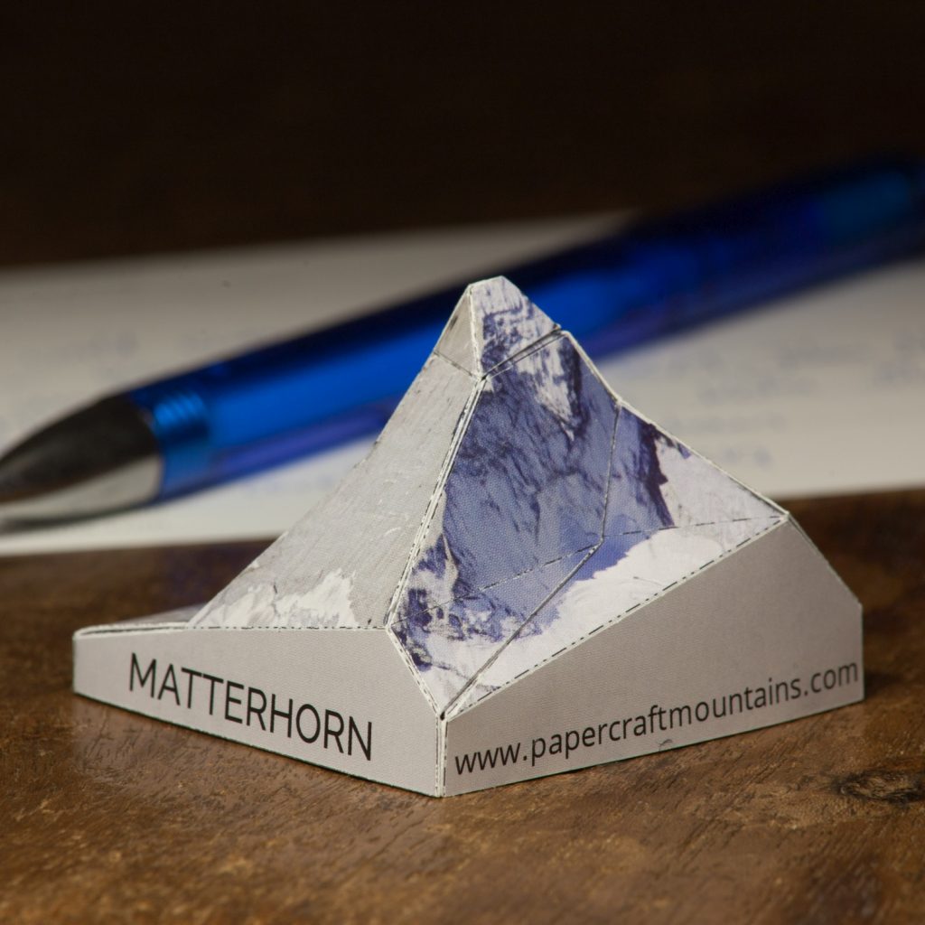
Baví vás origami, nebo alespoň skládání vlaštovek? Jakoba a Johanna ano, a tak vymysleli způsob, jak z DEMu udělat TIN a ten převést na origami – tak vznikl projekt PaperCraftMountains. Podobným způsobem tak vytvořili skládačky několika světových velehor – např. Uluru či Matterhorn. To, že jejich postup má vědecký základ dokazují nejen ve své prezentaci, […]
The post Origami pro geografy appeared first on GISportal.cz.
Space race hackathon - pozvánka
3.4.2019 7:00 Česká asociace pro geoinformaceVe dnech 26. až 28. dubna 2019 se v Olomouci na Katedře geoinformatiky UPOL koná Space Race Hackathon.
Přijďte si zahackovat na vesmírný hackathon v Olomouci a oslavit tak s námi 50. výročí jedné z nejodvážnějších misí v historii - Moon Landing.
Jak? Během 48 hodin vytvořte vlastní projekt na některou z výzev, třeba právě na moon challenge, přesvědčte porotu na