


![]()

zprávy
zdroje zpráv:Odborný referent – obnova katastrálního operátu v technickém odboru Katastrálního úřadu pro Moravsko
4.2.2019 16:24 ČÚZK - volná místa Katastrální úřad pro Moravskoslezský kraj - technický odbor vypisuje výběrové řízení na místo Odborný referent – obnova katastrálního operátu v technickém odboru Katastrálního úřadu pro MoravskoOdborný referent – obnova katastrálního operátu v technickém odboru Katastrálního úřadu pro Moravsko
4.2.2019 16:24 ČÚZK /Urady/Katastralni-urady/Katastralni-urady/Katastralni-urad-pro-Moravskoslezsky-kraj/Uredni-deska/Oznameni-a-jina-uredni-sdeleni/Volna-mista/Odborny-referent-–-obnova-katastralniho-operat-(1)Vrchní referent/rada – obnova katastrálního operátu v technickém odboru Katastrálního úřadu pro Mora
4.2.2019 16:22 ČÚZK /Urady/Katastralni-urady/Katastralni-urady/Katastralni-urad-pro-Moravskoslezsky-kraj/Uredni-deska/Oznameni-a-jina-uredni-sdeleni/Volna-mista/Vrchni-referent-rada-–-obnova-katastralniho-op-(3)Vrchní referent/rada – obnova katastrálního operátu v technickém odboru Katastrálního úřadu pro Mora
4.2.2019 16:22 ČÚZK - volná místa Katastrální úřad pro Moravskoslezský kraj - technický odbor vypisuje výběrové řízení na místo Vrchní referent/rada – obnova katastrálního operátu v technickém odboru Katastrálního úřadu pro MoraVrchní referent/rada – obnova katastrálního operátu v technickém odboru Katastrálního úřadu pro Mora
4.2.2019 16:22 ČÚZK - předpisy a opatření Katastrální úřad pro Moravskoslezský kraj - technický odborvypisuje výběrové řízení na místo
Vrchní referent/rada – obnova katastrálního operátu v technickém odboru Katastrálního úřadu pro Moravskoslezský kraj
Vrchní referent/rada – obnova katastrálního operátu na Katastrálním pracovišti Karviná Katastrálního
4.2.2019 16:21 ČÚZK - předpisy a opatření Katastrální úřad pro Moravskoslezský kraj - Katastrální pracoviště Karvinávypisuje výběrové řízení na místo
Vrchní referent/rada – obnova katastrálního operátu na Katastrálním pracovišti Karviná Katastrálního úřadu pro Moravskoslezský kraj
Vrchní referent/rada – obnova katastrálního operátu na Katastrálním pracovišti Karviná Katastrálního
4.2.2019 16:21 ČÚZK /Urady/Katastralni-urady/Katastralni-urady/Katastralni-urad-pro-Moravskoslezsky-kraj/Uredni-deska/Oznameni-a-jina-uredni-sdeleni/Volna-mista/Vrchni-referent-rada-–-obnova-katastralniho-op-(2)Vrchní referent/rada – obnova katastrálního operátu na Katastrálním pracovišti Karviná Katastrálního
4.2.2019 16:21 ČÚZK - volná místa Katastrální úřad pro Moravskoslezský kraj - Katastrální pracoviště Karviná vypisuje výběrové řízení na místo Vrchní referent/rada – obnova katastrálního operátu na Katastrálním pracovišti Karviná KatastrálníhoOdborný rada – vedoucí oddělení dokumentace KN na Katastrálním pracovišti Opava Katastrálního úřadu
4.2.2019 16:19 ČÚZK /Urady/Katastralni-urady/Katastralni-urady/Katastralni-urad-pro-Moravskoslezsky-kraj/Uredni-deska/Oznameni-a-jina-uredni-sdeleni/Volna-mista/Odborny-rada-–-vedouci-oddeleni-dokumentace-KN-naOdborný rada – vedoucí oddělení dokumentace KN na Katastrálním pracovišti Opava Katastrálního úřadu
4.2.2019 16:19 ČÚZK - předpisy a opatření Katastrální úřad pro Moravskoslezský kraj - Katastrální pracoviště Opavavypisuje výběrové řízení na místo
Odborný rada – vedoucí oddělení dokumentace KN na Katastrálním pracovišti Opava Katastrálního úřadu pro Moravskoslezský kraj
Odborný rada – vedoucí oddělení dokumentace KN na Katastrálním pracovišti Opava Katastrálního úřadu
4.2.2019 16:19 ČÚZK - volná místa Katastrální úřad pro Moravskoslezský kraj - Katastrální pracoviště Opava vypisuje výběrové řízení na místo Odborný rada – vedoucí oddělení dokumentace KN na Katastrálním pracovišti Opava Katastrálního úřaduCelofiremní školení – Březnice 2019
4.2.2019 15:44 HrdličkaToto firemní školení mělo hned několik cílů. Prvním cílem byly odborné semináře, v rámci, kterých se naši kolegové dozvěděli o nových technologických postupech, rozšiřující si povědomí o našich službách a tím tak prohloubili svoje odborné kompetence. V odpoledním bloku pak proběhla prezentace vedení společností v rámci Hrdlička holdingu. Bilancoval se uplynulý rok 2018 a představovala... View Article
The post Celofiremní školení – Březnice 2019 appeared first on HRDLIČKA spol. s r.o. - komplexní služby v oblasti geodézie.
Odborný referent v oddělení obnovy katastrálního operátu na Technické sekci
4.2.2019 14:35 ČÚZK /Urady/Katastralni-urady/Katastralni-urady/Katastralni-urad-pro-Jihomoravsky-kraj/Volna-mista/Odborny-referent-v-oddeleni-obnovy-katastralniho-oGSA opens new GSMC invitation to tenders
4.2.2019 14:35 European GNSS Agency
The European GNSS Agency (GSA) has just opened an invitation to tenders targeting the development of an “Operational Interface System for the GSMC”.
The Galileo Security Monitoring Centre (GSMC) has space constraints in the TEMPEST secure area which, in turn, is putting a damper on the deployment of the system. These constraints are primarily due to the fact that dedicated terminals and desktops are physically attached to each system in the GSMC sites. As a result, when the number of systems grows, the required number of terminals also increases.
Scope of the Call
To address this situation, the GSA aims to procure a security accredited operational interface system (OIS) that connects each of the GSA systems and their instances to every workstation in the appropriate operational area. The OIS/KVM switch will allow multiple users to access any of the interconnected systems’ instances via any of the workstations.
The baseline for this Contract is to have a minimum of eight workstations with OIS accessibility designed, developed and deployed at the GSMC site in Saint-Germain-en-Laye, France (GSMC-FR).
The OIS design shall allow:
- Management of physical space constraints,
- Operators to work more efficiently from a single workplace instead of moving between the current standalone workplaces,
- Improvements of work flexibility, and
- Improvements of scalability for the future deployment of the systems.
If you would like to find out more on how to prepare a successful bid, register to take part in a dedicated webinar to be held on 19 February 2019. At the webinar, GSA staff will present the technical and administrative requirements, as well as the optional functionalities and cyber requirements necessary to prepare a successful bid.
The Call at a Glance |
|||
| Deadline for submission of bids: | 1 May 2019 | ||
| Expected signature of contract: | July 2019 | ||
| EU budget: | EUR 950,000 (100 % funding) | ||
| Webinar date: | 19 February 2019 (registration to open soon) | ||
| To apply, click here. |
Role of GSMC in the Galileo Programme
The Galileo Security Monitoring Centre (GSMC) is an operational centre of the GSA and an integral part of the Galileo infrastructure. Its mission is to provide an EU facility that offers a secure way for Public Regulated Service (PRS) users to interact with the Galileo System Operator.
This will simplify the operation of the Galileo system and provide assurance to PRS users that sensitive information related to their use of Galileo is properly managed and protected. The GSMC also coordinates the implementation of Joint Action instructions received from the EU SitCen (Situation Centre).
The GSA is responsible for the operation of the GSMCs within the Galileo system, undertaking the following specific missions:
- Management of PRS access,
- Galileo security monitoring,
- Response to European GNSS crisis and security events,
- Provision of European GNSS security expertise and analysis.
Media note: This feature can be republished without charge provided the European GNSS Agency (GSA) is acknowledged as the source at the top or the bottom of the story. You must request permission before you use any of the photographs on the site. If you republish, we would be grateful if you could link back to the GSA website (http://www.gsa.europa.eu).
GSA opens new GSMC invitation to tenders
4.2.2019 14:35 European GNSS AgencyThe European GNSS Agency (GSA) has just opened an invitation to tenders targeting the development of an “Operational Interface System for the GSMC”.
The Galileo Security Monitoring Centre (GSMC) has space constraints in the TEMPEST secure area which, in turn, is putting a damper on the deployment of the system. These constraints are primarily due to the fact that dedicated terminals and desktops are physically attached to each system in the GSMC sites. As a result, when the number of systems grows, the required number of terminals also increases.
Scope of the Call
To address this situation, the GSA aims to procure a security accredited operational interface system (OIS) that connects each of the GSA systems and their instances to every workstation in the appropriate operational area. The OIS/KVM switch will allow multiple users to access any of the interconnected systems’ instances via any of the workstations.
The baseline for this Contract is to have a minimum of eight workstations with OIS accessibility designed, developed and deployed at the GSMC site in Saint-Germain-en-Laye, France (GSMC-FR).
The OIS design shall allow:
- Management of physical space constraints,
- Operators to work more efficiently from a single workplace instead of moving between the current standalone workplaces,
- Improvements of work flexibility, and
- Improvements of scalability for the future deployment of the systems.
If you would like to find out more on how to prepare a successful bid, register to take part in a dedicated webinar to be held on 19 February 2019, from 11.00 am to 12.00 pm CET. At the webinar, GSA staff will present the technical and administrative requirements, as well as the optional functionalities and cyber requirements necessary to prepare a successful bid. You can join the webinar here.
The Call at a Glance |
|||
| Deadline for submission of bids: | 2 May 2019 | ||
| Expected signature of contract: | July 2019 | ||
| EU budget: | EUR 950,000 (100 % funding) | ||
| Webinar date: | 19 February 2019, 11.00 CET | ||
| To apply, click here. |
Role of GSMC in the Galileo Programme
The Galileo Security Monitoring Centre (GSMC) is an operational centre of the GSA and an integral part of the Galileo infrastructure. Its mission is to provide an EU facility that offers a secure way for Public Regulated Service (PRS) users to interact with the Galileo System Operator.
This will simplify the operation of the Galileo system and provide assurance to PRS users that sensitive information related to their use of Galileo is properly managed and protected. The GSMC also coordinates the implementation of Joint Action instructions received from the EU SitCen (Situation Centre).
The GSA is responsible for the operation of the GSMCs within the Galileo system, undertaking the following specific missions:
- Management of PRS access,
- Galileo security monitoring,
- Response to European GNSS crisis and security events,
- Provision of European GNSS security expertise and analysis.
Webinar details
When: 19 February 2019, from 11.00 am to 12.00 pm CET.
Join the webinar here. To find how to register and participate in the dedicated webinar, please read all the instructions here.
Media note: This feature can be republished without charge provided the European GNSS Agency (GSA) is acknowledged as the source at the top or the bottom of the story. You must request permission before you use any of the photographs on the site. If you republish, we would be grateful if you could link back to the GSA website (http://www.gsa.europa.eu).
Odborný referent v oddělení obnovy katastrálního operátu na Technické sekci
4.2.2019 14:35 ČÚZK - předpisy a opatření Katastrální úřad pro Jihomoravský kraj - technická sekcenabízí služební místo
Odborný referent v oddělení obnovy katastrálního operátu na Technické sekci
GSA opens new GSMC invitation to tenders
4.2.2019 14:35 European GNSS Agency
The European GNSS Agency (GSA) has just opened an invitation to tenders targeting the development of an “Operational Interface System for the GSMC”.
The Galileo Security Monitoring Centre (GSMC) has space constraints in the TEMPEST secure area which, in turn, is putting a damper on the deployment of the system. These constraints are primarily due to the fact that dedicated terminals and desktops are physically attached to each system in the GSMC sites. As a result, when the number of systems grows, the required number of terminals also increases.
Scope of the Call
To address this situation, the GSA aims to procure a security accredited operational interface system (OIS) that connects each of the GSA systems and their instances to every workstation in the appropriate operational area. The OIS/KVM switch will allow multiple users to access any of the interconnected systems’ instances via any of the workstations.
The baseline for this Contract is to have a minimum of eight workstations with OIS accessibility designed, developed and deployed at the GSMC site in Saint-Germain-en-Laye, France (GSMC-FR).
The OIS design shall allow:
- Management of physical space constraints,
- Operators to work more efficiently from a single workplace instead of moving between the current standalone workplaces,
- Improvements of work flexibility, and
- Improvements of scalability for the future deployment of the systems.
If you would like to find out more on how to prepare a successful bid, take part in a dedicated webinar to be held on 19 February 2019, from 11.00 am to 12.00 pm CET. At the webinar, GSA staff will present the technical and administrative requirements, as well as the optional functionalities and cyber requirements necessary to prepare a successful bid. You can join the webinar here.
The Call at a Glance |
|||
| Deadline for submission of bids: | 2 May 2019 | ||
| Expected signature of contract: | July 2019 | ||
| EU budget: | EUR 950,000 (100 % funding) | ||
| Webinar date: | 19 February 2019, 11.00 CET | ||
| To apply, click here. |
Role of GSMC in the Galileo Programme
The Galileo Security Monitoring Centre (GSMC) is an operational centre of the GSA and an integral part of the Galileo infrastructure. Its mission is to provide an EU facility that offers a secure way for Public Regulated Service (PRS) users to interact with the Galileo System Operator.
This will simplify the operation of the Galileo system and provide assurance to PRS users that sensitive information related to their use of Galileo is properly managed and protected. The GSMC also coordinates the implementation of Joint Action instructions received from the EU SitCen (Situation Centre).
The GSA is responsible for the operation of the GSMCs within the Galileo system, undertaking the following specific missions:
- Management of PRS access,
- Galileo security monitoring,
- Response to European GNSS crisis and security events,
- Provision of European GNSS security expertise and analysis.
Webinar details
When: 19 February 2019, from 11.00 am to 12.00 pm CET.
Join the webinar here. To find how to register and participate in the dedicated webinar, please read all the instructions here.
Media note: This feature can be republished without charge provided the European GNSS Agency (GSA) is acknowledged as the source at the top or the bottom of the story. You must request permission before you use any of the photographs on the site. If you republish, we would be grateful if you could link back to the GSA website (http://www.gsa.europa.eu).
GSA opens new GSMC invitation to tenders
4.2.2019 14:35 European GNSS AgencyThe European GNSS Agency (GSA) has just opened an invitation to tenders targeting the development of an “Operational Interface System for the GSMC”.
The Galileo Security Monitoring Centre (GSMC) has space constraints in the TEMPEST secure area which, in turn, is putting a damper on the deployment of the system. These constraints are primarily due to the fact that dedicated terminals and desktops are physically attached to each system in the GSMC sites. As a result, when the number of systems grows, the required number of terminals also increases.
Scope of the Call
To address this situation, the GSA aims to procure a security accredited operational interface system (OIS) that connects each of the GSA systems and their instances to every workstation in the appropriate operational area. The OIS/KVM switch will allow multiple users to access any of the interconnected systems’ instances via any of the workstations.
The baseline for this Contract is to have a minimum of eight workstations with OIS accessibility designed, developed and deployed at the GSMC site in Saint-Germain-en-Laye, France (GSMC-FR).
The OIS design shall allow:
- Management of physical space constraints,
- Operators to work more efficiently from a single workplace instead of moving between the current standalone workplaces,
- Improvements of work flexibility, and
- Improvements of scalability for the future deployment of the systems.
If you would like to find out more on how to prepare a successful bid, register to take part in a dedicated webinar to be held on 19 February 2019, from 11.00 am to 12.00 pm CET. At the webinar, GSA staff will present the technical and administrative requirements, as well as the optional functionalities and cyber requirements necessary to prepare a successful bid. You can join the webinar here.
The Call at a Glance |
|||
| Deadline for submission of bids: | 2 May 2019 | ||
| Expected signature of contract: | July 2019 | ||
| EU budget: | EUR 950,000 (100 % funding) | ||
| Webinar date: | 19 February 2019, 11.00 CET | ||
| To apply, click here. |
Role of GSMC in the Galileo Programme
The Galileo Security Monitoring Centre (GSMC) is an operational centre of the GSA and an integral part of the Galileo infrastructure. Its mission is to provide an EU facility that offers a secure way for Public Regulated Service (PRS) users to interact with the Galileo System Operator.
This will simplify the operation of the Galileo system and provide assurance to PRS users that sensitive information related to their use of Galileo is properly managed and protected. The GSMC also coordinates the implementation of Joint Action instructions received from the EU SitCen (Situation Centre).
The GSA is responsible for the operation of the GSMCs within the Galileo system, undertaking the following specific missions:
- Management of PRS access,
- Galileo security monitoring,
- Response to European GNSS crisis and security events,
- Provision of European GNSS security expertise and analysis.
Webinar details
When: 19 February 2019, from 11.00 am to 12.00 pm CET.
Join the webinar here. To find how to register and participate in the dedicated webinar, please read all the instructions here.
Media note: This feature can be republished without charge provided the European GNSS Agency (GSA) is acknowledged as the source at the top or the bottom of the story. You must request permission before you use any of the photographs on the site. If you republish, we would be grateful if you could link back to the GSA website (http://www.gsa.europa.eu).
GSA opens new GSMC invitation to tenders
4.2.2019 14:35 European GNSS AgencyThe European GNSS Agency (GSA) has just opened an invitation to tenders targeting the development of an “Operational Interface System for the GSMC”.
The Galileo Security Monitoring Centre (GSMC) has space constraints in the TEMPEST secure area which, in turn, is putting a damper on the deployment of the system. These constraints are primarily due to the fact that dedicated terminals and desktops are physically attached to each system in the GSMC sites. As a result, when the number of systems grows, the required number of terminals also increases.
Scope of the Call
To address this situation, the GSA aims to procure a security accredited operational interface system (OIS) that connects each of the GSA systems and their instances to every workstation in the appropriate operational area. The OIS/KVM switch will allow multiple users to access any of the interconnected systems’ instances via any of the workstations.
The baseline for this Contract is to have a minimum of eight workstations with OIS accessibility designed, developed and deployed at the GSMC site in Saint-Germain-en-Laye, France (GSMC-FR).
The OIS design shall allow:
- Management of physical space constraints,
- Operators to work more efficiently from a single workplace instead of moving between the current standalone workplaces,
- Improvements of work flexibility, and
- Improvements of scalability for the future deployment of the systems.
If you would like to find out more on how to prepare a successful bid, register to take part in a dedicated webinar to be held on 19 February 2019, from 11 am to 12 pm CET. At the webinar, GSA staff will present the technical and administrative requirements, as well as the optional functionalities and cyber requirements necessary to prepare a successful bid. You can register in the webinar here.
The Call at a Glance |
|||
| Deadline for submission of bids: | 2 May 2019 | ||
| Expected signature of contract: | July 2019 | ||
| EU budget: | EUR 950,000 (100 % funding) | ||
| Webinar date: | 19 February 2019 (registration to open soon) | ||
| To apply, click here. |
Role of GSMC in the Galileo Programme
The Galileo Security Monitoring Centre (GSMC) is an operational centre of the GSA and an integral part of the Galileo infrastructure. Its mission is to provide an EU facility that offers a secure way for Public Regulated Service (PRS) users to interact with the Galileo System Operator.
This will simplify the operation of the Galileo system and provide assurance to PRS users that sensitive information related to their use of Galileo is properly managed and protected. The GSMC also coordinates the implementation of Joint Action instructions received from the EU SitCen (Situation Centre).
The GSA is responsible for the operation of the GSMCs within the Galileo system, undertaking the following specific missions:
- Management of PRS access,
- Galileo security monitoring,
- Response to European GNSS crisis and security events,
- Provision of European GNSS security expertise and analysis.
Webinar details
When: 19 February 2019, from 11 am to 12 pm CET
Register to the webinar here.
Media note: This feature can be republished without charge provided the European GNSS Agency (GSA) is acknowledged as the source at the top or the bottom of the story. You must request permission before you use any of the photographs on the site. If you republish, we would be grateful if you could link back to the GSA website (http://www.gsa.europa.eu).
Odborný referent v oddělení obnovy katastrálního operátu na Technické sekci
4.2.2019 14:35 ČÚZK - volná místa Katastrální úřad pro Jihomoravský kraj - technická sekce vypisuje výběrové řízení na místo Odborný referent v oddělení obnovy katastrálního operátu na Technické sekciGSA opens new GSMC invitation to tenders
4.2.2019 14:35 European GNSS AgencyThe European GNSS Agency (GSA) has just opened an invitation to tenders targeting the development of an “Operational Interface System for the GSMC”.
The Galileo Security Monitoring Centre (GSMC) has space constraints in the TEMPEST secure area which, in turn, is putting a damper on the deployment of the system. These constraints are primarily due to the fact that dedicated terminals and desktops are physically attached to each system in the GSMC sites. As a result, when the number of systems grows, the required number of terminals also increases.
Scope of the Call
To address this situation, the GSA aims to procure a security accredited operational interface system (OIS) that connects each of the GSA systems and their instances to every workstation in the appropriate operational area. The OIS/KVM switch will allow multiple users to access any of the interconnected systems’ instances via any of the workstations.
The baseline for this Contract is to have a minimum of eight workstations with OIS accessibility designed, developed and deployed at the GSMC site in Saint-Germain-en-Laye, France (GSMC-FR).
The OIS design shall allow:
- Management of physical space constraints,
- Operators to work more efficiently from a single workplace instead of moving between the current standalone workplaces,
- Improvements of work flexibility, and
- Improvements of scalability for the future deployment of the systems.
If you would like to find out more on how to prepare a successful bid, register to take part in a dedicated webinar to be held on 19 February 2019, from 11.00 am to 12.00 pm CET. At the webinar, GSA staff will present the technical and administrative requirements, as well as the optional functionalities and cyber requirements necessary to prepare a successful bid. You can join the webinar here.
The Call at a Glance |
|||
| Deadline for submission of bids: | 2 May 2019 | ||
| Expected signature of contract: | July 2019 | ||
| EU budget: | EUR 950,000 (100 % funding) | ||
| Webinar date: | 19 February 2019, 11.00 CET | ||
| To apply, click here. |
Role of GSMC in the Galileo Programme
The Galileo Security Monitoring Centre (GSMC) is an operational centre of the GSA and an integral part of the Galileo infrastructure. Its mission is to provide an EU facility that offers a secure way for Public Regulated Service (PRS) users to interact with the Galileo System Operator.
This will simplify the operation of the Galileo system and provide assurance to PRS users that sensitive information related to their use of Galileo is properly managed and protected. The GSMC also coordinates the implementation of Joint Action instructions received from the EU SitCen (Situation Centre).
The GSA is responsible for the operation of the GSMCs within the Galileo system, undertaking the following specific missions:
- Management of PRS access,
- Galileo security monitoring,
- Response to European GNSS crisis and security events,
- Provision of European GNSS security expertise and analysis.
Webinar details
When: 19 February 2019, from 11.00 am to 12.00 pm CET.
Join the webinar here. To find how to register and participate in the dedicated webinar, please read all the instructions here.
Media note: This feature can be republished without charge provided the European GNSS Agency (GSA) is acknowledged as the source at the top or the bottom of the story. You must request permission before you use any of the photographs on the site. If you republish, we would be grateful if you could link back to the GSA website (http://www.gsa.europa.eu).
GSA opens new GSMC invitation to tenders
4.2.2019 14:35 European GNSS AgencyThe European GNSS Agency (GSA) has just opened an invitation to tenders targeting the development of an “Operational Interface System for the GSMC”.
The Galileo Security Monitoring Centre (GSMC) has space constraints in the TEMPEST secure area which, in turn, is putting a damper on the deployment of the system. These constraints are primarily due to the fact that dedicated terminals and desktops are physically attached to each system in the GSMC sites. As a result, when the number of systems grows, the required number of terminals also increases.
Scope of the Call
To address this situation, the GSA aims to procure a security accredited operational interface system (OIS) that connects each of the GSA systems and their instances to every workstation in the appropriate operational area. The OIS/KVM switch will allow multiple users to access any of the interconnected systems’ instances via any of the workstations.
The baseline for this Contract is to have a minimum of eight workstations with OIS accessibility designed, developed and deployed at the GSMC site in Saint-Germain-en-Laye, France (GSMC-FR).
The OIS design shall allow:
- Management of physical space constraints,
- Operators to work more efficiently from a single workplace instead of moving between the current standalone workplaces,
- Improvements of work flexibility, and
- Improvements of scalability for the future deployment of the systems.
If you would like to find out more on how to prepare a successful bid, register to take part in a dedicated webinar to be held on 19 February 2019. At the webinar, GSA staff will present the technical and administrative requirements, as well as the optional functionalities and cyber requirements necessary to prepare a successful bid.
The Call at a Glance |
|||
| Deadline for submission of bids: | 2 May 2019 | ||
| Expected signature of contract: | July 2019 | ||
| EU budget: | EUR 950,000 (100 % funding) | ||
| Webinar date: | 19 February 2019 (registration to open soon) | ||
| To apply, click here. |
Role of GSMC in the Galileo Programme
The Galileo Security Monitoring Centre (GSMC) is an operational centre of the GSA and an integral part of the Galileo infrastructure. Its mission is to provide an EU facility that offers a secure way for Public Regulated Service (PRS) users to interact with the Galileo System Operator.
This will simplify the operation of the Galileo system and provide assurance to PRS users that sensitive information related to their use of Galileo is properly managed and protected. The GSMC also coordinates the implementation of Joint Action instructions received from the EU SitCen (Situation Centre).
The GSA is responsible for the operation of the GSMCs within the Galileo system, undertaking the following specific missions:
- Management of PRS access,
- Galileo security monitoring,
- Response to European GNSS crisis and security events,
- Provision of European GNSS security expertise and analysis.
Media note: This feature can be republished without charge provided the European GNSS Agency (GSA) is acknowledged as the source at the top or the bottom of the story. You must request permission before you use any of the photographs on the site. If you republish, we would be grateful if you could link back to the GSA website (http://www.gsa.europa.eu).
GSA opens new GSMC invitation to tenders
4.2.2019 14:35 European GNSS AgencyThe European GNSS Agency (GSA) has just opened an invitation to tenders targeting the development of an “Operational Interface System for the GSMC”.
The Galileo Security Monitoring Centre (GSMC) has space constraints in the TEMPEST secure area which, in turn, is putting a damper on the deployment of the system. These constraints are primarily due to the fact that dedicated terminals and desktops are physically attached to each system in the GSMC sites. As a result, when the number of systems grows, the required number of terminals also increases.
Scope of the Call
To address this situation, the GSA aims to procure a security accredited operational interface system (OIS) that connects each of the GSA systems and their instances to every workstation in the appropriate operational area. The OIS/KVM switch will allow multiple users to access any of the interconnected systems’ instances via any of the workstations.
The baseline for this Contract is to have a minimum of eight workstations with OIS accessibility designed, developed and deployed at the GSMC site in Saint-Germain-en-Laye, France (GSMC-FR).
The OIS design shall allow:
- Management of physical space constraints,
- Operators to work more efficiently from a single workplace instead of moving between the current standalone workplaces,
- Improvements of work flexibility, and
- Improvements of scalability for the future deployment of the systems.
If you would like to find out more on how to prepare a successful bid, register to take part in a dedicated webinar to be held on 19 February 2019, from 11.00 am to 12.00 pm CET. At the webinar, GSA staff will present the technical and administrative requirements, as well as the optional functionalities and cyber requirements necessary to prepare a successful bid. You can register for the webinar here.
The Call at a Glance |
|||
| Deadline for submission of bids: | 2 May 2019 | ||
| Expected signature of contract: | July 2019 | ||
| EU budget: | EUR 950,000 (100 % funding) | ||
| Webinar date: | 19 February 2019, 11.00 CET | ||
| To apply, click here. |
Role of GSMC in the Galileo Programme
The Galileo Security Monitoring Centre (GSMC) is an operational centre of the GSA and an integral part of the Galileo infrastructure. Its mission is to provide an EU facility that offers a secure way for Public Regulated Service (PRS) users to interact with the Galileo System Operator.
This will simplify the operation of the Galileo system and provide assurance to PRS users that sensitive information related to their use of Galileo is properly managed and protected. The GSMC also coordinates the implementation of Joint Action instructions received from the EU SitCen (Situation Centre).
The GSA is responsible for the operation of the GSMCs within the Galileo system, undertaking the following specific missions:
- Management of PRS access,
- Galileo security monitoring,
- Response to European GNSS crisis and security events,
- Provision of European GNSS security expertise and analysis.
Webinar details
When: 19 February 2019, from 11.00 am to 12.00 pm CET.
Register to the webinar here. To find how to register and participate in the dedicated webinar, please read all the instructions here.
Media note: This feature can be republished without charge provided the European GNSS Agency (GSA) is acknowledged as the source at the top or the bottom of the story. You must request permission before you use any of the photographs on the site. If you republish, we would be grateful if you could link back to the GSA website (http://www.gsa.europa.eu).
Odborný referent/vrchní referent v oddělení obnovy katastrálního operátu č. 1 na Technické sekci
4.2.2019 14:31 ČÚZK /Urady/Katastralni-urady/Katastralni-urady/Katastralni-urad-pro-Jihomoravsky-kraj/Uredni-deska/Oznameni-a-jina-uredni-sdeleni/Volna-mista/Odborny-referent-vrchni-referent-v-oddeleni-obnovyOdborný referent/vrchní referent v oddělení obnovy katastrálního operátu č. 1 na Technické sekci
4.2.2019 14:31 ČÚZK - předpisy a opatření Katastrální úřad pro Jihomoravský kraj - technická sekcevypisuje výběrové řízení na místo
Odborný referent/vrchní referent v oddělení obnovy katastrálního operátu č. 1 na Technické sekci
Odborný referent/vrchní referent v oddělení obnovy katastrálního operátu č. 1 na Technické sekci
4.2.2019 14:31 ČÚZK - volná místa Katastrální úřad pro Jihomoravský kraj - technická sekce vypisuje výběrové řízení na místo Odborný referent/vrchní referent v oddělení obnovy katastrálního operátu č. 1 na Technické sekciOdborný referent v oddělení obnovy katastrálního operátu č. 3 na Technické sekci
4.2.2019 14:27 ČÚZK - předpisy a opatření Katastrální úřad pro Jihomoravský kraj - technická sekcevypisuje výběrové řízení na místo
Odborný referent v oddělení obnovy katastrálního operátu č. 3 na Technické sekci
Odborný referent v oddělení obnovy katastrálního operátu č. 3 na Technické sekci
4.2.2019 14:27 ČÚZK - volná místa Katastrální úřad pro Jihomoravský kraj - technická sekce vypisuje výběrové řízení na místo Odborný referent v oddělení obnovy katastrálního operátu č. 3 na Technické sekciOdborný referent v oddělení obnovy katastrálního operátu č. 3 na Technické sekci
4.2.2019 14:27 ČÚZK /Urady/Katastralni-urady/Katastralni-urady/Katastralni-urad-pro-Jihomoravsky-kraj/Uredni-deska/Oznameni-a-jina-uredni-sdeleni/Volna-mista/Odborny-referent-v-oddeleni-obnovy-katastralniho-oVrchní referent/rada v oddělení obnovy katastrálního operátu č. 2 na Technické sekci
4.2.2019 14:24 ČÚZK - volná místa Katastrální úřad pro Jihomoravský kraj - technická sekce vypisuje výběrové řízení na místo Vrchní referent/rada v oddělení obnovy katastrálního operátu č. 2 na Technické sekciVrchní referent/rada v oddělení obnovy katastrálního operátu č. 2 na Technické sekci
4.2.2019 14:24 ČÚZK /Urady/Katastralni-urady/Katastralni-urady/Katastralni-urad-pro-Jihomoravsky-kraj/Uredni-deska/Oznameni-a-jina-uredni-sdeleni/Volna-mista/Vrchni-referent-rada-v-oddeleni-obnovy-katastralniVrchní referent/rada v oddělení obnovy katastrálního operátu č. 2 na Technické sekci
4.2.2019 14:24 ČÚZK - předpisy a opatření Katastrální úřad pro Jihomoravský kraj - technická sekcevypisuje výběrové řízení na místo
Vrchní referent/rada v oddělení obnovy katastrálního operátu č. 2 na Technické sekci
20190204-Aktualizovány otázky-oprávnění zeměměřičských činností
4.2.2019 13:36 ČÚZK - předpisy a opatření Český úřad zeměměřický a katastrálnízveřejnil novou aktualitu: Aktualizovány otázky ke zvláštní části zkoušky pro udělení úředního oprávnění pro ověřování výsledků zeměměřických činností podle § 13 odst. 1 písm. c) zákona č. 200/1994 Sb., o zeměměřictví a o změně a doplnění některých zákonů souvisejících s jeho zavedením, ve znění pozdějších předpisů.
20190204-Aktualizovány otázky-oprávnění zeměměřičských činností
4.2.2019 13:36 ČÚZK /Aktuality-resort/2019/20190204-Aktualizovany-otazky-opravneni-zememerics20190204-Aktualizovány otázky-oprávnění zeměměřičských činností
4.2.2019 13:36 ČÚZK - aktuality v resortu Aktualizovány otázky ke zvláštní části zkoušky pro udělení úředního oprávnění pro ověřování výsledků zeměměřických činností podle § 13 odst. 1 písm. c) zákona č. 200/1994 Sb., o zeměměřictví a o změně a doplnění některých zákonů souvisejících s jeho zavedením, ve znění pozdějších předpisů.20190204-Aktualizovány otázky-oprávnění zeměměřičských činností
4.2.2019 13:36 ČÚZK - předpisy a opatření Český úřad zeměměřický a katastrální zveřejnil novou aktualitu: Aktualizovány otázky ke zvláštní části zkoušky pro udělení úředního oprávnění pro ověřování výsledků zeměměřických činností podle § 13 odst. 1 písm. c) zákona č. 200/1994 Sb., o zeměměřictví a o změně a doplnění některých zákonů souvisejících s jeho zavedením, ve znění pozdějších předpisů.Vítězné nápady 3D tisku na Měsíci
4.2.2019 13:15 Český Kosmický PortálPři studování konceptů lunární základny vyhlásila ESA soutěž s dotazem: co byste si chtěli vytisknout na 3D tiskárně na Měsíci, abyste se cítili jako doma? Odpovědi přišly z celého světa. Nyní byli vybráni dva vítězové, přičemž oba jejich nápady jsou spojené s přírodou.
Vítězné nápady 3D tisku na Měsíci
4.2.2019 13:15 Český Kosmický PortálPři studování konceptů lunární základny vyhlásila ESA soutěž s dotazem: co byste si chtěli vytisknout na 3D tiskárně na Měsíci, abyste se cítili jako doma? Odpovědi přišly z celého světa. Nyní byli vybráni dva vítězové, přičemž oba jejich nápady jsou spojené s přírodou.
Povodňový plán - aktualizace
4.2.2019 12:45 Středočeský kraj Byla aktualizována webová aplikace Povodňový plán. Zpracovatelem aplikace je společnost Hydrosoft Veleslavín s.r.o..Vyhlášení platnosti OKO v k.ú. Kamenická Stráň
4.2.2019 12:10 ČÚZK /Urady/Katastralni-urady/Katastralni-urady/Katastralni-urad-pro-Ustecky-kraj/Katastralni-pracoviste/KP-Decin/O-uradu/Aktuality/Vyhlaseni-platnosti-OKO-v-k-u-Kamenicka-StranVyhlášení platnosti OKO v k.ú. Kamenická Stráň
4.2.2019 12:10 ČÚZK - předpisy a opatření Katastrální úřad pro Ústecký kraj - Katastrální pracoviště Děčín zveřejnil novou aktualitu: Katastrální úřad pro Ústecký kraj, Katastrální pracoviště Děčín vyhlašuje platnost obnoveného katastrálního operátu v části katastrálního území Kamenická Stráň obce Růžová.Časopis, televize, noviny, rozhlas – zkušenosti z médií se dozvíte na 13. kartografickém dni
4.2.2019 11:39 GeoBusiness Třinácté setkání nazvané Kartografický den se letos uskuteční 22. února. Do Olomouce přijedou své zkušenosti z médií předat infografik časopisu Týden, šéfgrafik zpravodajského webu ... PřečístVrchní referent v oddělení aktualizace a dokumentace katastru nemovitostí Katastrálního pracoviště N
4.2.2019 11:32 ČÚZK - předpisy a opatření Katastrální úřad pro Královéhradecký kraj - Katastrální pracoviště Náchodvypisuje výběrové řízení na místo
Vrchní referent v oddělení aktualizace a dokumentace katastru nemovitostí Katastrálního pracoviště Náchod
Vrchní referent v oddělení aktualizace a dokumentace katastru nemovitostí Katastrálního pracoviště N
4.2.2019 11:32 ČÚZK /Urady/Katastralni-urady/Katastralni-urady/Katastralni-urad-pro-Kralovehradecky-kraj/Uredni-deska/Oznameni-a-jina-uredni-sdeleni/Volna-mista/Vrchni-referent-v-oddeleni-aktualizace-a-dokumentaVrchní referent v oddělení aktualizace a dokumentace katastru nemovitostí Katastrálního pracoviště N
4.2.2019 11:32 ČÚZK - volná místa Katastrální úřad pro Královéhradecký kraj - Katastrální pracoviště Náchod vypisuje výběrové řízení na místo Vrchní referent v oddělení aktualizace a dokumentace katastru nemovitostí Katastrálního pracoviště NReferáty Kartografického dne, letos věnovaného médiím
4.2.2019 11:02 Zeměměřič Časopisy, noviny, televize, rozhlas, nová média - referáty letošního kartografického setkání budou zaměřené na média.Nedostupnost Národního geoportálu INSPIRE
4.2.2019 10:39 CENIA - národní geoportál INSPIRE Z důvodu plánované údržby v pondělí 4. února 2019 od 8:00 do 16:00 můžou být dočasně nedostupné webové stránky Národního geoportálu INSPIRE. Děkujeme za pochopení.More of Africa scarred by fires than thought
4.2.2019 10:19 ESA Observing the Earth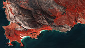
Wildfires can cause devastation and are also to blame for more than a quarter of greenhouse gases being released into the atmosphere. Satellites play a key role in mapping landscape scarred by fire – but the Copernicus Sentinel-2 mission has revealed that there are more fires than previously thought.
Stipendijní místa ke studiu BP/DP/DSP v Číně
4.2.2019 10:05 Blogující geomatici - FAV ZČU Z pověření Ministerstva školství, mládeže a tělovýchovy ČR bychom Vás rádi informovali o tom, že čínská vláda nabízí českým zájemcům v rámci iniciativy 16+1 stipendijní místa ke studiu v bakalářských, magisterských a doktorských studijních programech v ČLR počínajeakademickým rokem 2019/2020, jakož i ke studijním či výzkumným stážím v
ČLR v délce jednoho až dvou semestrů v akademickém roce 2019/2020.
*Termín pro odevzdání přihlášek je 15. února 2019 do 15 hod.*
Zájemci doručí požadované dokumenty ve stanoveném termínu na Odbor mezinárodních vztahů MŠMT.
Podrobné informace k výběrovému řízení jsou zveřejněny na webových stránkách Akademické informační agentury (AIA):
https://www.dzs.cz/cz/akademicka-informacni-agentura/stipendia/?type_id=6&country_id=10.
Známe program 13. kartografického dne Olomouc (pozvánka)
4.2.2019 8:57 GISportal.cz
Na webu 13. kartografického dne Olomouc, který nese podtitul kartografie a média, byl zveřejněn program letošního ročníku veřejného semináře. Těšit se můžete na příspěvky věnované mapám v tisku, rozhlase i televizi. Jistě vás zaujme také unikátní sbírka předpovědních map počasí čítající přes 200 exponátů ze 45 zemí světa, nebudou chybět ani tzv. nová média. Seminář […]
The post Známe program 13. kartografického dne Olomouc (pozvánka) appeared first on GISportal.cz.
Známe program 13. kartografického dne Olomouc (pozvánka)
4.2.2019 8:57 GISportal.czNa webu 13. kartografického dne Olomouc, který nese podtitul kartografie a média, byl zveřejněn program letošního ročníku veřejného semináře. Těšit se můžete na příspěvky věnované mapám v tisku, rozhlase i televizi. Jistě vás zaujme také unikátní sbírka předpovědních map počasí čítající přes 200 exponátů ze 45 zemí světa, nebudou chybět ani tzv. nová média. Seminář […]
The post Známe program 13. kartografického dne Olomouc (pozvánka) appeared first on GISportal.cz.
Výroční zpráva dle zákona č. 106/1999 Sb. za rok 2018
4.2.2019 8:32 ČÚZK - předpisy a opatření Katastrální úřad pro Ústecký krajvydává výroční zprávu úřadu za rok
2018
Výroční zpráva dle zákona č. 106/1999 Sb. za rok 2018
4.2.2019 8:32 ČÚZK /Urady/Katastralni-urady/Katastralni-urady/Katastralni-urad-pro-Ustecky-kraj/Vyrocni-zpravy/Vyrocni-zprava-dle-zakona-c-106-1999-Sb-za-rok-(1)Rozpočet úřadu za rok 2019
4.2.2019 8:30 ČÚZK /Urady/Katastralni-urady/Katastralni-urady/Katastralni-urad-pro-Ustecky-kraj/Rozpocet/Rozpocet-uradu-za-rok-2019Rozpočet úřadu za rok 2019
4.2.2019 8:30 ČÚZK - předpisy a opatření Katastrální úřad pro Ústecký krajvystavuje rozpočet úřadu za rok
2019
Kite-blown Antarctic explorers make most southerly Galileo positioning fix
4.2.2019 8:12 ESA Navigation
A kite-blown science expedition to the interior of Antarctica has made the most southerly positioning fixes yet made with Europe’s Galileo satellite navigation system.
Kite-blown Antarctic explorers make most southerly Galileo positioning fix
4.2.2019 8:12 ESA NavigationA kite-blown science expedition to the interior of Antarctica has made the most southerly positioning fixes yet made with Europe’s Galileo satellite navigation system.
GIVS 2019 - polovina míst na konferenci je již obsazená
4.2.2019 7:00 Česká asociace pro geoinformaceDva týdny po spuštění registrace na letošní ročník konference Geoinformace ve veřejné správě 2019 je již téměř polovina míst v konferenčním sále obsazená. Pokud se chcete zúčastnit i Vy, neotálejte a přihlašte se prostřednictvím webového formuláře na stránkách konference. Do 15. března je navíc registrace na GIVS za zvýhodněné vložné.
Vše podstatné o
InterDev Launches Location Intelligence Labs; Offers Cutting-Edge Geospatial Technology Services Including Drone-Powered Imaging
4.2.2019 5:10 GISCafe.com Webcasts-Webinars InterDev has introduced the use of drone technology to create 3D models of city parks and other main attraction sites. This allows organizations such …Pozvánka na ples pražské zeměměřické průmyslovky
4.2.2019 3:02 Zeměměřič Studenti 4. ročníku SPŠZ srdečně zvou na svůj maturitní ples.Současný stav využití území
4.2.2019 1:00 Cenia - Katalog metadat ČR - INSPIRE Plochy využití území a krajiny v podrobnosti měřítka 1 : 5 000. Data pocházejí z průzkumů IPR Praha, který probíhá od roku 2012.Legenda obsahuje celkem 127 podrobných kódů využití území v těchto nadřazených tématech:- krajina- vodní toky a plochy- sport a rekreace- občanské vybavení veřejné infrastruktury- občanské vybavení – obchod, služby- bydlení- produkce, těžba, odpady- dopravní infrastruktura- veřejná prostranství – komunikace- technická infrastruktura- plochy bez využití.Generel páteřních a hlavních cyklistických tras hl. m. Prahy
4.2.2019 1:00 Cenia - Katalog metadat ČR - INSPIRE plán rozvoje cyklistické dopravy v Praze - hlavní a páteřní trasyVeřejně přístupné plochy
4.2.2019 1:00 Cenia - Katalog metadat ČR - INSPIRE Služba zobrazuje soubor informací o veřejně přístupných plochách v Praze. Mezi ně jsou zahrnuta data o parteru, údaje o prostupnosti územím / ploty a bariéry, hierarchie veřejně přístupných ploch a data o vybavenosti veřejných prostranství. Do služby je rovněž zahrnuta klasifikace uliční sítě podle několika atributů (střední výška / střední šířka ulic, vzdálenost zástavby a počet podlaží).Výšky
4.2.2019 1:00 Cenia - Katalog metadat ČR - INSPIRE Vybrané ukazatele o výškových poměrech v Praze získané především analytickými postupy:- výška obvodových linií střech- počet podlaží stanovený pro jednotlivé budovy- typická podlažnost v rastru (čtverci) o rozměrech 100x100 m- klasifikace střešní krajinyLokality
4.2.2019 1:00 Cenia - Katalog metadat ČR - INSPIRE Lokality – jednotky vymezené na základě převažujícího charakteru území – jsou ve službě zobrazeny dvojím způsobem. Jednak podle způsobu využití (obytné, rekreační, krajinné, produkční a ostatní neurčené) a dále podle struktury či typu (město / krajina a další podrobné členění).
Pozvánka na letní školu v Indii
4.2.2019 0:00 Geografický ústav MUGeografický ústav PřF MU a Katedra environmentálních studií FSS MU nabízí studentům v magisterských a doktorských studijních programech možnost semestrálního (čtyřměsíčního) studijního pobytu na univerzitě v indické Mumbaí.
Bližší informace naleznete ZDE.
GIS Specialist Position in UIUC Library
3.2.2019 18:59 Geographic Information Science (GIS) Specialist – Scholarly Commons Academic Professional University of Illinois Library at Urbana-Champaign Position Available: Position available immediately. This is a 100% time, 12 month appointment academic position in the University Library. Position Function/Summary: The Geographic Information Science (GIS) Specialist plays a critical role in the development, growth, and stability of the University […]PhD position Urban modelling in Amsterdam
3.2.2019 18:58 PhD–POSITION URBAN MODELLING At SPINlab, dept. Spatial Economics Vrije Universiteit Amsterdam, The Netherlands For the recently approved SIMITRI project (funded by JPI-Urban Europe and NSFC) we are looking for a PhD researcher that will develop an urban land use and transport modelling environment. Building on recent experience with of state-of-the-art land-use models applied in the […]Markus Neteler bude přednášet v Praze
2.2.2019 22:30 GeoBusiness Jedna z významných osobností open sourceového gisového světa Markus Neteler, který v 90. letech významně posunul vývoj GRASS GIS, bude přednášet v Praze. Vyzvaná ... PřečístUSC SPATIAL SCIENCES INSTITUTE TO HOST 2019 LOS ANGELES GEOSPATIAL SUMMIT
1.2.2019 19:27 GISCafe.com Webcasts-Webinars USC RADISSON HOTEL – FEBRUARY 22, 2019University of Southern California will assemble geospatial industry experts (Esri, Google, Northrop …
Autodesk Extends Invitation to Join Financial Results Conference Call
1.2.2019 17:01 GISCafe.com Webcasts-Webinars Fourth Quarter Fiscal 2019 Financial Results Conference Call to be Held Thursday, February 28, 2:00 p.m. Pacific TimeSAN RAFAEL, Calif., Feb. 1, …
Register for LPS19
1.2.2019 14:30 ESA Observing the Earth
Registration is open for ESA’s next Living Planet Symposium, which will take place on 13–19 May 2019 in Milan, Italy. Deadline: 30 April
20190201
1.2.2019 12:58 ČÚZK /Urady/Katastralni-urady/Katastralni-urady/Katastralni-urad-pro-Vysocinu/Katastralni-pracoviste/KP-Zdar-nad-Sazavou/O-uradu/Aktuality/2019020120190201
1.2.2019 12:58 ČÚZK - předpisy a opatření Katastrální úřad pro Vysočinu - Katastrální pracoviště Žďár nad Sázavou zveřejnil novou aktualitu: Oznámení o změně úředních hodin na kontaktním místě Bystřice nad Pernštejnem20190201
1.2.2019 12:58 ČÚZK - předpisy a opatření Český úřad zeměměřický a katastrální - Katastrální pracoviště Žďár nad Sázavou zveřejnil novou aktualitu: Oznámení o změně úředních hodin na kontaktním místě Bystřice nad PernštejnemLaserová družice EDRS-C by měla být v květnu vynesena na oběžnou dráhu
1.2.2019 12:42 GeoBusiness Předchozích šest měsíců byla družice EDRS-C vystavena otřesům, hluku nebo nárazům. Těmito zkouškami úspěšně prošla, a může si tak odškrtnout další milník na cestě ... PřečístNová metodika pro pozemkové úpravy
1.2.2019 12:11 Asociace podnikatelů v geomatice Veškeré pozemkové úpravy se nyní budou řídit jinými zásadami, jejichž cílem je především zlepšit stav naší krajiny. Sedm nových principů představil Petr Sklenička, rektor České zemědělské univerzity v Praze. Veškerá opatření v rámci pozemkových úprav budou dimenzována na klimatické podmínky po roce 2050 (uvedený princip označil Sklenička za nejdůležitější). Oproti stávající prioritě retence vody v krajině (krátkodobé zadržení […]Getting ready for the evolution of EGNOS
1.2.2019 11:48 European GNSS Agency
The EGNOS Service Provision (ESP) consists in delivering three types of services: the Open Service (OS), the Safety of Life service (SoL) and EGNOS Data Access Services (EDAS). The current EGNOS System was developed in early 2000’s, and is to be replaced by a new generation “EGNOS V 3”.
This latter will augment both GPS and Galileo, provide additional SBAS service capabilities through a new SBAS channel on L5 and will benefit from a reinforced security to increase the robustness of EGNOS services to potential threats.
Presently, the provision of EGNOS Services is ensured via the current ESP contract, which continues until the end of 2021, as a baseline.
The next EGNOS Service Provider is expected to be in charge of the delivery of EGNOS services based on EGNOS Version 2 infrastructure first, then on EGNOS Version 3 infrastructure.
The contract is expected to be signed before end-2020, with a duration of 6 to 8 years.
The GSA has published a Prior Information Notice OJ/S S22 31/01/2019 47118-2019-EN in the Official Journal of the European Union, containing the above and further information for the contemplated procurement.
The full Prior Information Notice may be found here.
Media note: This feature can be republished without charge provided the European GNSS Agency (GSA) is acknowledged as the source at the top or the bottom of the story. You must request permission before you use any of the photographs on the site. If you republish, we would be grateful if you could link back to the GSA website (http://www.gsa.europa.eu).
Getting ready for the evolution of EGNOS
1.2.2019 11:48 European GNSS AgencyThe EGNOS Service Provision (ESP) consists in delivering three types of services: the Open Service (OS), the Safety of Life service (SoL) and EGNOS Data Access Services (EDAS). The current EGNOS System was developed in early 2000’s, and is to be replaced by a new generation “EGNOS V3”.
This latter will augment both GPS and Galileo, provide additional SBAS service capabilities through a new SBAS channel on L5 and will benefit from a reinforced security to increase the robustness of EGNOS services to potential threats.
Presently, the provision of EGNOS Services is ensured via the current ESP contract, which continues until the end of 2021, as a baseline.
The next EGNOS Service Provider is expected to be in charge of the delivery of EGNOS services based on EGNOS V2 infrastructure first, then on EGNOS V3 infrastructure.
The contract is expected to be signed before end-2020, with a duration of 6 to 8 years.
The GSA has published a Prior Information Notice OJ/S S22 31/01/2019 47118-2019-EN in the Official Journal of the European Union, containing the above and further information for the contemplated procurement.
The full Prior Information Notice may be found here.
Media note: This feature can be republished without charge provided the European GNSS Agency (GSA) is acknowledged as the source at the top or the bottom of the story. You must request permission before you use any of the photographs on the site. If you republish, we would be grateful if you could link back to the GSA website (http://www.gsa.europa.eu).
"Summary of GISCafe Industry Predictions for 2019" by Susan Smith
1.2.2019 11:03 GISCafe.com Webcasts-WebinarsIraq flood
1.2.2019 10:05 ESA Observing the Earth
Earth observation image of the week: Copernicus Sentinel-1 takes us to one of the areas in Iraq that suffered flooding recently
Earth from Space
1.2.2019 10:05 ESA Observing the Earth
This week's edition features a Copernicus Sentinel-1 image over eastern Iraq
Kinesis Vehicle Telematics Helps Lincolnshire Security Guard the Guards
1.2.2019 9:00 GISCafe.com Webcasts-Webinars January 31, 2019 -- Kinesis vehicle telematics is giving Lincolnshire Security complete visibility of its mobile operation. Offering a wide range of …Horizon, the New High Performance IMU to Complete the Navsight Land/Air Solution
1.2.2019 9:00 GISCafe.com Webcasts-Webinars Carrières-sur-seine, France, January 29th 2019 - SBG Systems releases at the International LiDAR Mapping Forum (ILMF) in Denver, U.S.A, the …thinkWhere Helps Falkirk Tackle Poverty with Open Geographic Data
1.2.2019 9:00 GISCafe.com Webcasts-Webinars January 28, 2019 -- thinkWhere is working with Falkirk Council in Scotland to develop a new mapping tool that aims to help improve the lives of its …Rozšiřte náš tým! Hledáme nového kolegu na pozici referenta Geoinformatiky
1.2.2019 8:00 Český Kosmický PortálMáte nadšení do práce? Vyznáte se v GIS aplikacích a prostorových datech? Pak neváhejte a posilte náš tým na perspektivní pozici Geoinformatik! Přihlášky je možno podávat do 28. února 2019.
Rozšiřte náš tým! Hledáme nového kolegu na pozici referenta Geoinformatiky
1.2.2019 8:00 Český Kosmický PortálMáte nadšení do práce? Vyznáte se v GIS aplikacích a prostorových datech? Pak neváhejte a posilte náš tým na perspektivní pozici Geoinformatik! Přihlášky je možno podávat do 28. února 2019.
Pozvánka na workshop - Indoor cartography
1.2.2019 7:00 Česká asociace pro geoinformacePozvánka na workshop - Indoor cartography
Ve dnech 10. až. 12. června se ve Znojmě uskuteční v rámci konference Kognice a umělý život 2020 workshop na téma Indoor Cartography.
Ve dnech 10. až. 12. června se ve Znojmě uskuteční v rámci konference Kognice a umělý život 2020 workshop na téma Indoor
Zeměměřický úřad hledá geografa
1.2.2019 7:00 Česká asociace pro geoinformaceZeměměřický úřád hledá geografa
Zeměměřický úřad hledá zaměstnance pro správu a rozvoj Základní báze geografických dat pro pracoviště v Praze. Hlavní náplní práce na této pozici je samostatné vyhledávání a ověřování nových informačních zdrojů pro aktualizaci ZABAGED®, jejich posuzování a navrhování způsobu jejich využití a začlenění do
Digital Map Products Adds Location Technology Veteran Dave Cozzens to Board of Directors
1.2.2019 1:11 GISCafe.com Webcasts-Webinars IRVINE, Calif. — (BUSINESS WIRE) — January 31, 2019 —Digital Map Products Inc. (DMP), a leading provider of location
…
Digital Map Products Adds Location Technology Veteran Dave Cozzens to Board of Directors
1.2.2019 1:11 GISCafe.com Webcasts-Webinars IRVINE, Calif. — (BUSINESS WIRE) — January 31, 2019 — Digital Map Products Inc. (DMP), a leading provider of location intelligence …APGEO - NOVÁ METODIKA PRO POZEMKOVÉ ÚPRAVY
1.2.2019 1:00 Asociace podnikatelů v geomatice Veškeré pozemkové úpravy se nyní budou řídit jinými zásadami, jejichž cílem je především zlepšit stav naší krajiny...Mimovegetační ortofotomapa Prahy 2016
1.2.2019 1:00 Cenia - Katalog metadat ČR - INSPIRE ortofotomapa 2016 mimovegetačníMimovegetační ortofotomapa Prahy 2015
1.2.2019 1:00 Cenia - Katalog metadat ČR - INSPIRE ortofotomapa 2015 mimovegetačníMimovegetační ortofotomapa Prahy 2014
1.2.2019 1:00 Cenia - Katalog metadat ČR - INSPIRE ortofotomapa 2014 mimovegetačníBudovy
1.2.2019 1:00 Cenia - Katalog metadat ČR - INSPIRE Služba obsahuje cache polygonů budov. V měřítku do 1: 10 000 se zobrazují budovy Digitální technické mapy. V měřítcích 1: 10 000 až 1: 50 000 jsou ve službě bloky budov ze Základní mapy 1: 25 000. Budovy ze Zabagedu jsou použity pro Středočeský kraj ve všech měřítcích a od měřítka 1: 50 000 do 1: 750 000 jsou použity i v Praze.Nabídka pro Ph.D. studenty na stáž ve Francii
1.2.2019 0:00 Geografický ústav MUFrancouzské velvyslanectví v ČR nabízí studentům českých vysokých škol možnost získat stipendium francouzské vlády na doktorandské studium.
Bližší informace naleznete ZDE.
Pozemkové úpravy umí pomoci naší krajině v mnoha směrech
1.2.2019 0:00 Státní pozemkový úřad Praha, 1. února 2019 – Pozemkové úpravy jsou jednou z nosných agend Státního pozemkového úřadu (SPÚ). Díky jejich realizaci se umí příroda snáze vypořádat s negativními jevy klimatických změn, jako jsou povodně nebo naopak dlouhá období sucha. SPÚ eviduje schválené návrhy pozemkových úprav na cca 33% výměry celého zemědělského půdního fondu, na dalších zhruba 13% půdy jsou pozemkové úpravy rozpracované. Jedná se o 2 402 ukončených komplexních a 2 921 ukončených jednoduchých pozemkových úprav. Aktuálně je v celé České republice rozpracováno 1 060 komplexních a 110 jednoduchých pozemkových úprav.CompassDrone, Newest Division Of CompassData, Integrates UAV LiDAR Solutions
31.1.2019 22:39 GISCafe.com Webcasts-Webinars FOR IMMEDIATE RELEASE
CompassDrone, Newest Division Of CompassData, Integrates UAV LiDAR Solutions
LiDAR data in conjunction with existing …
CompassDrone, Newest Division Of CompassData, Integrates UAV LiDAR Solutions
31.1.2019 22:39 GISCafe.com Webcasts-Webinars LiDAR data in conjunction with existing survey data provides both accuracy and reliability to existing collection workflowsCentennial, CO – …
Svaz podnikatelů ve stavebnictví má po 14 letech nového prezidenta
31.1.2019 17:46 GeoBusiness Svaz podnikatelů ve stavebnictví, který byl založen v roce 1990, oznámil ke konci prosince 2018 nového prezidenta. Stal se jím Jiří Nouza, jenž ve ... PřečístthinkWhere Creates Map Portal for Open European Geographic Data
31.1.2019 17:03 GISCafe.com Webcasts-Webinars January 31, 2019 -- thinkWhere is developing an online mapping portal to improve access to official European geospatial open data. Working with …ARC Advisory Group Report Names Esri GIS Market Leader
31.1.2019 17:01 GISCafe.com Webcasts-Webinars Market Analysis Gives Esri Top Ranking among GIS Providers inUtilities and Infrastructure
REDLANDS, Calif. — …
Drone Delivery Canada Receives Approvals to Start Testing its 50 lbs Cargo Delivery Drone - The Falcon
31.1.2019 17:01 GISCafe.com Webcasts-Webinars TORONTO, Jan. 30, 2019 — (PRNewswire) — Drone Delivery Canada 'DDC or the Company' (TSX.V:FLT, OTC:TAKOF), is pleased to announce that …ARC Advisory Group Report Names Esri GIS Market Leader
31.1.2019 17:01 GISCafe.com Webcasts-Webinars Market Analysis Gives Esri Top Ranking among GIS Providers in Utilities and Infrastructure
REDLANDS, Calif. — (BUSINESS WIRE) — …
NorthStar Earth & Space partners with SpecTIR to deliver complete hyperspectral image services
31.1.2019 17:01 GISCafe.com Webcasts-Webinars MONTREAL, Jan. 31, 2019 — (PRNewswire) — NorthStar Earth & Space Inc. is pleased to announce a strategic partnership with …CoreLogic to Announce Fourth Quarter and Full-Year 2018 Financial Results
31.1.2019 17:01 GISCafe.com Webcasts-Webinars IRVINE, Calif. — (BUSINESS WIRE) — January 31, 2019 —CoreLogic® (NYSE: CLGX), a leading global provider of
property …
Drone Aviation Secures an Additional $2.0 Million in Capital, Completing Private Placement Raising an Aggregate of $4.0 Million
31.1.2019 17:01 GISCafe.com Webcasts-Webinars JACKSONVILLE, FL, Jan. 31, 2019 (GLOBE NEWSWIRE) -- Drone Aviation Holding Corp. (OTCQB: DRNE) (“Drone Aviation” or the “Company”), a …INCATech Receives the Release Ready Specialty Partner Designation from Esri
31.1.2019 17:01 GISCafe.com Webcasts-Webinars INCATech receives the Release Ready Specialty Partner designation from Esri®.RESTON, Va., Jan. 31, 2019 — (PRNewswire) —
RESTON, …
Intermap Technologies Announces Website Improvements
31.1.2019 17:01 GISCafe.com Webcasts-Webinars DENVER, Jan. 31, 2019 — (PRNewswire) — Intermap Technologies Corporation has updated its corporate website, www.intermap.com, and …NAVISP fostering technologies for Europe’s new age of navigation
31.1.2019 16:48 ESA Navigation
At ESA, the field of navigation covers more than just Galileo and satnav-sharpening EGNOS. More than a hundred European experts attended the inaugural NAVISP workshop at ESA’s technical heart, to discuss current R&D on a huge range of navigation-related topics, from driverless boats to intelligent power lines.
NAVISP fostering technologies for Europe’s new age of navigation
31.1.2019 16:48 ESA NavigationAt ESA, the field of navigation covers more than just Galileo and satnav-sharpening EGNOS. More than a hundred European experts attended the inaugural NAVISP workshop at ESA’s technical heart, to discuss current R&D on a huge range of navigation-related topics, from driverless boats to intelligent power lines.
Galileo is key to Europe's digital economy
31.1.2019 16:28 European GNSS Agency
At the 11th European Space Policy Conference in Brussels, GSA Executive Director Carlo des Dorides explained why Europe's flagship satellite navigation system, Galileo, is a cornerstone of the strategy for a European Single Digital Economy.
The global economy is rapidly being digitised. Information and communications technologies are no longer confined to a specific sector but constitute the foundation of all modern innovative economic systems. Connectivity, in particular, is now seen as a key enabler of a multitude of new services that are transforming the global scene.
"The future of intelligent connectivity is going hand-in-hand with the future of GNSS," said GSA Executive Director Carlo des Dorides, speaking at the 11th European Space Policy Conference in Brussels.
Important milestone
The term ‘intelligent connectivity’ describes the powerful combination of flexible, high-speed 5G networks, the Internet of Things (IoT), artificial intelligence (AI) and big data. Today, location plays a major role in all of these developments, with navigation and Earth observation data combining to provide the needed geographical framework to deliver personalised services.
"Just last month, in December 2018, we achieved a very important milestone," said des Dorides, "namely that more than fifty percent of the worldwide population is now connected to the digital world, to the Internet."
Read this: EU Space enables an interconnected future
It also means that the other fifty percent will be getting connected in the coming years, and this will revolutionise the way individuals think and societies operate. People today and people tomorrow will be connected in new and different ways. They will have different needs and will use their connectivity for as yet unimagined purposes.
"We can see that this expansion is continuing and the growth rate is really amazing," des Dorides said. "So we are in the age of what some people are describing as a 'silent revolution'. Every day we are seeing more and more new users and new ways to connect to the growing digital world."
Hard work rewarded
The GSA has been working ceaselessly to ensure the widespread uptake of European GNSS technologies, including Galileo and EGNOS, and the efforts have been paying off. An important element is the incorporation of Galileo-enabled GNSS receivers in handheld devices, such as smartphones.
"We have some other very important figures to mention," said des Dorides. "Today we have more subscriptions worldwide for mobile phones than inhabitants in the world, and with all that, around seventy percent of these digital devices are broadband-enabled. So this is the connection with the digital world."
Des Dorides talked about the closing gap between the physical world and the digital world: "There is a clear convergence, and the catalyst, the enabler, is the Internet of Things, the ubiquitous things, and the best example of ubiquitous things are our smartphones – this is the context we are living in. We also know that at the basis of the ubiquitous things is geo-positioning, and in particular GNSS. Fifty percent of our apps in our smartphones require geo-positioning and ninety percent of those require GNSS, so here is the link with GNSS."
It should also be noted that in addition to location information, accurate timing delivered by GNSS is providing an indispensable tool for precisely synchronising transactions, including those operated by Digitally Autonomous Organisations in a distributed ledger. Apart from accurate timing, there is also a critical role for GNSS in the authentication of smart contracts, which is an important way to increase security of transactions. Galileo will provide a unique authentication feature with its service.
"In all of these areas, there is a GNSS-based silent revolution happening right now," said des Dorides. "In 2011 an important new feature was multi-constellation, which is now in all our phones. This means a more reliable performance, with more available positioning and timing.”
Watch this: European Space Programmes: Empowering Digital Markets
"Then last year we also had a very important new milestone with the introduction of dual frequency, which will guarantee better accuracy on the mass market. GNSS, and Galileo in particular, is granting a flexible connection with the Internet of Things, the digital world, and big data."
GNSS and Europe's Digital Strategy
The rapid digitisation being seen in so many areas and at such a scale and speed bring immense opportunities for innovation, growth and jobs. It also raises challenging policy issues for public authorities that require coordinated EU action. All Member States are wrestling with similar problems, but on a national basis, which is too limited to allow them to seize all the opportunities and deal with all the issues raised by these profoundly transformational developments. That is why the European Commission has set the creation of a Digital Single Market for Europe as one of its key priorities, with digital autonomy in particular as a strategic goal.
Also speaking at the event in Brussels was Mariya Gabriel, EU Commissioner for Digital Economy and Society. She said the European space programmes have a key role to play in support of the European Digital Single Market: "We need to be moving to digital autonomy and sovereignty in Europe. The space sector can help us get there, from satellites for 5G coverage to important Earth Observation services of Copernicus and of course the critical geo-localisation capacity enabled by Galileo."
Indeed, at a time of increasing geopolitical uncertainty, Galileo is now inarguably a critical infrastructure. Today, European GNSS is used to synchronise mobile networks, energy grids and financial transactions. It is used in emergency services, in safety-critical operations and, with the advent of AI and automation, driverless cars, drones and other autonomous systems will need GNSS for navigation.
In any number of vital application areas, including all that concerns the digital economy, Galileo is a key enabler of European independence and sovereignty, at the same time built to be interoperable with all the other GNSS systems in the world and able to provide a fully autonomous European solution.
Media note: This feature can be republished without charge provided the European GNSS Agency (GSA) is acknowledged as the source at the top or the bottom of the story. You must request permission before you use any of the photographs on the site. If you republish, we would be grateful if you could link back to the GSA website (http://www.gsa.europa.eu).
Malaysia’s Mass Rapid Transit Corporation taps the power of Microsoft Azure
31.1.2019 15:37 Bentley SystemsPress Coverage
Microsoft, USA
Read the articleAPM Solution Improves Reliability at Oman Gas Company
31.1.2019 15:28 Bentley SystemsPress Coverage
ARC Web, USA
Read the articleOptioneering Helps MidCoast Water Transform Gloucester Water Network Into A Reliable, Efficient System
31.1.2019 15:24 Bentley SystemsPress Coverage
Water Online, USA
Read the articleReliability Radio EP 151: Interview With Anne Marie Walters
31.1.2019 15:12 Bentley SystemsPress Coverage
ReliabilityWeb, USA
Read the article