


![]()

zprávy
zdroje zpráv:Odborný rada – vedoucí oddělení dokumentace KN
13.12.2018 13:03 ČÚZK - volná místa Katastrální úřad pro Moravskoslezský kraj vypisuje výběrové řízení na místo Odborný rada – vedoucí oddělení dokumentace KNOdborný referent v oddělení aktualizace a dokumentace KN KP Chomutov na Katastrálním úřadu pro Ústec
13.12.2018 13:00 ČÚZK - předpisy a opatření Katastrální úřad pro Ústecký kraj - Katastrální pracoviště Chomutovvypisuje výběrové řízení na místo
Odborný referent v oddělení aktualizace a dokumentace KN KP Chomutov na Katastrálním úřadu pro Ústecký kraj
Odborný referent v oddělení aktualizace a dokumentace KN KP Chomutov na Katastrálním úřadu pro Ústec
13.12.2018 13:00 ČÚZK /Urady/Katastralni-urady/Katastralni-urady/Katastralni-urad-pro-Ustecky-kraj/Uredni-deska/Oznameni-a-jina-uredni-sdeleni/Volna-mista/Odborny-referent-v-oddeleni-aktualizace-a-dokumentOdborný referent v oddělení aktualizace a dokumentace KN KP Chomutov na Katastrálním úřadu pro Ústec
13.12.2018 13:00 ČÚZK - volná místa Katastrální úřad pro Ústecký kraj - Katastrální pracoviště Chomutov vypisuje výběrové řízení na místo Odborný referent v oddělení aktualizace a dokumentace KN KP Chomutov na Katastrálním úřadu pro ÚstecEurope flying high at 2018 EU Space Week
13.12.2018 12:47 European GNSS Agency
Europe's flagship space programmes, Galileo and Copernicus, serve as powerful tools for tackling today's economic, social, and environmental challenges, creating real opportunities for money making and job creation. This year's EU Space Week, which took place in the beautiful port city of Marseille, provided ample opportunities for reflection and exchange of ideas as the European space sector continues to move forward.
The 2018 EU Space Week opening plenary brought together an impressive array of key figures from the public sector and industry to deliver valuable insights into where the European space sector stands and where it is going.
The message from the European Commission was clear and simple: “Space is essential for our economy," said Elzbieta Bieńkowska, European Commissioner for Internal Market, Industry, Entrepreneurship and SMEs. "We are not investing in space for the sake of space, but because of the benefits it brings to our citizens and society.”
The Commissioner's comments came with EU Parliament and Member States in the midst of negotiations concerning the next EU space budget. The current proposal sees about EUR 16 billion being invested during the period 2021-2027 to further strengthen Europe's leadership position in space. The new space programme, with a budget 50% higher than that of the previous seven year period, will solidify the EU's role as a world space player, successfully competing with both state and private-sector actors.
“Galileo, EGNOS and Copernicus are world-class European success stories,” Bieńkowska said. “We have fought hard to keep them funded and we can see the results.”
Tangible outcomes
The European space sector employs over 231,000 professionals, with an estimated value of EUR 53-62 billion in 2017. Europe manufactures an astonishing one third of all the world's satellites. Galileo programme successes enumerated by Bieńkowska include recent satellite launches, bringing the system nearer and nearer to full operational capacity. And, she said, Galileo Initial Services, launched in December 2016, have surpassed all expectations in terms of performance. The coming months and years will see new Galileo services coming on line, including the secure Public Regulated Service (PRS), the Search and Rescue service (SAR) and a free high-accuracy service, among others.
Galileo is certainly leading the way in the area of dual-frequency signal delivery, now with more dual-frequency operational satellites in orbit than any other GNSS system. And market uptake of Galileo receivers has been impressive, with 500 million Galileo-enabled smartphones now on the market, thanks largely to the efforts of the European GNSS Agency (GSA). Marseille native and President of the French Space Agency (CNES) Jean-Yves Le Gall called Galileo a “fine testimony” to European teamwork.
For European GNSS Agency (GSA) Executive Director Carlo des Dorides, the success of Galileo has had a lot to do with forward thinking and constant contact with user communities. "We did a lot of preparatory work to ensure market uptake," he said. "We had to get to know the people we were talking to, such as the chip set and receiver manufacturers. And we had financial tools in place to help facilitate their decision making." There is still work to be done, Bieńkowska said, arguing, for example, for a change of mind-set needed to keep young European space entrepreneurs in Europe, through greater private investment and venture capitalism.
Cooperation and competition were the key words for European Space Agency (ESA) Director General Jan Wörner. He said competition is good, but he added: “To remain strong and autonomous, Europe also needs to focus on cooperation. We need to continue to come together, to join forces.” Wörner also reminded gathered participants of the important role of space in stimulating and inspiring young people.
Inspiring words
Another source of inspiration for the gathered delegates was Simonetta Di Pippo, the Director of the United Nations Office for Outer Space Affairs (UNOOSA). She spoke of unlocking the full potential of the global talent pool under the UN's boldest sustainable development agenda ever. "We are seeing an expanding portfolio of opportunities and invaluable partnerships are being created," she said, "bringing more and more countries into the space community."
Read this: European GNSS and Earth Observation: A promising convergence for sustainable development
Pierre Delsaux, Deputy Director General for DG GROW, European Commission, referenced the recent decision by the US Federal Communications Commission (FCC) approving the use of Galileo In the United States. "This is a clear sign of the increasing global acceptance of European space leadership."
Aiming his comments directly at the gathered European space community, Delsaux said: "These systems, Galileo and Copernicus, are infrastructure tools for innovation and growth on Earth. We, the European institutions, are not in charge of innovation. Our role is to deliver the tools, to set the legal environment, to remove barriers. But innovation is done by you, the people on the ground. I am truly proud of the work you are doing."
Responding to Bieńkowska comments on the lack of enthusiasm shown by European venture capital, Delsaux said: "We have capacity, we have venture capital, but in Europe the money is sleeping in bank accounts. We must change our mentality. The US dares to do innovation. We should do more.”
Business perspectives
In addition to the policy-related presentations, the opening plenary also featured round-table discussions with representatives of businesses that are turning space-based data from Galileo and Copernicus into valuable services on the ground.
Michael Bültmann, Managing Director of HERE Deutschland, talked about how his company is putting space data to work: “Every industry needs location data to maximize value. Intelligent use of high-quality location data gives us the real-time information and insights that not only unlock the power of burgeoning technologies, such as autonomous vehicle navigation, but enable greater accuracy and efficiency across sectors."
From pinpointing and tracking assets, Bültmann said, to managing fleets, improving traffic flow and creating better urban infrastructure, satellite technologies are now playing an increasingly important role in improving the quality of all manner of data and thereby enhancing a wide range of business opportunities.
In today's increasingly unpredictable geopolitical context, space activities are a strategic game changer. Space is a question of science, exploration and international cooperation and, through critical programmes such as Galileo and Copernicus, space plays a very practical role in terms of boosting innovation, economic growth and security.
With over a thousand participants the 2018 edition of EU Space Week provided an ideal forum for leaders, as well as key user communities, to network, talk about projects and perspectives, and to recognise the best of Europe's GNSS researchers and entrepreneurs.
Media note: This feature can be republished without charge provided the European GNSS Agency (GSA) is acknowledged as the source at the top or the bottom of the story. You must request permission before you use any of the photographs on the site. If you republish, we would be grateful if you could link back to the GSA website (http://www.gsa.europa.eu).
Europe flying high at 2018 EU Space Week
13.12.2018 12:47 European GNSS AgencyEurope's flagship space programmes, Galileo and Copernicus, serve as powerful tools for tackling today's economic, social, and environmental challenges, creating real opportunities for money making and job creation. This year's EU Space Week, which took place in the beautiful port city of Marseille, provided ample opportunities for reflection and exchange of ideas as the European space sector continues to move forward.
The 2018 EU Space Week opening plenary brought together an impressive array of key figures from the public sector and industry to deliver valuable insights into where the European space sector stands and where it is going.
The message from the European Commission was clear and simple: “Space is essential for our economy," said Elzbieta Bieńkowska, European Commissioner for Internal Market, Industry, Entrepreneurship and SMEs. "We are not investing in space for the sake of space, but because of the benefits it brings to our citizens and society.”
Watch this: EU Space Week in Marseille, 3 - 6 December 2018
The Commissioner's comments came with EU Parliament and Member States in the midst of negotiations concerning the next EU space budget. The current proposal sees about EUR 16 billion being invested during the period 2021-2027 to further strengthen Europe's leadership position in space. The new space programme, with a budget 50% higher than that of the previous seven year period, will solidify the EU's role as a world space player, successfully competing with both state and private-sector actors.
“Galileo, EGNOS and Copernicus are world-class European success stories,” Bieńkowska said. “We have fought hard to keep them funded and we can see the results.”
Tangible outcomes
The European space sector employs over 231,000 professionals, with an estimated value of EUR 53-62 billion in 2017. Europe manufactures an astonishing one third of all the world's satellites. Galileo programme successes enumerated by Bieńkowska include recent satellite launches, bringing the system nearer and nearer to full operational capacity. And, she said, Galileo Initial Services, launched in December 2016, have surpassed all expectations in terms of performance. The coming months and years will see new Galileo services coming on line, including the secure Public Regulated Service (PRS), the Search and Rescue service (SAR) and a free high-accuracy service, among others.
Galileo is certainly leading the way in the area of dual-frequency signal delivery, now with more dual-frequency operational satellites in orbit than any other GNSS system. And market uptake of Galileo receivers has been impressive, with 500 million Galileo-enabled smartphones now on the market, thanks largely to the efforts of the European GNSS Agency (GSA). Marseille native and President of the French Space Agency (CNES) Jean-Yves Le Gall called Galileo a “fine testimony” to European teamwork.
For European GNSS Agency (GSA) Executive Director Carlo des Dorides, the success of Galileo has had a lot to do with forward thinking and constant contact with user communities. "We did a lot of preparatory work to ensure market uptake," he said. "We had to get to know the people we were talking to, such as the chip set and receiver manufacturers. And we had financial tools in place to help facilitate their decision making." There is still work to be done, Bieńkowska said, arguing, for example, for a change of mind-set needed to keep young European space entrepreneurs in Europe, through greater private investment and venture capitalism.
Cooperation and competition were the key words for European Space Agency (ESA) Director General Jan Wörner. He said competition is good, but he added: “To remain strong and autonomous, Europe also needs to focus on cooperation. We need to continue to come together, to join forces.” Wörner also reminded gathered participants of the important role of space in stimulating and inspiring young people.
Inspiring words
Another source of inspiration for the gathered delegates was Simonetta Di Pippo, the Director of the United Nations Office for Outer Space Affairs (UNOOSA). She spoke of unlocking the full potential of the global talent pool under the UN's boldest sustainable development agenda ever. "We are seeing an expanding portfolio of opportunities and invaluable partnerships are being created," she said, "bringing more and more countries into the space community."
Read this: European GNSS and Earth Observation: A promising convergence for sustainable development
Pierre Delsaux, Deputy Director General for DG GROW, European Commission, referenced the recent decision by the US Federal Communications Commission (FCC) approving the use of Galileo In the United States. "This is a clear sign of the increasing global acceptance of European space leadership."
Aiming his comments directly at the gathered European space community, Delsaux said: "These systems, Galileo and Copernicus, are infrastructure tools for innovation and growth on Earth. We, the European institutions, are not in charge of innovation. Our role is to deliver the tools, to set the legal environment, to remove barriers. But innovation is done by you, the people on the ground. I am truly proud of the work you are doing."
Responding to Bieńkowska comments on the lack of enthusiasm shown by European venture capital, Delsaux said: "We have capacity, we have venture capital, but in Europe the money is sleeping in bank accounts. We must change our mentality. The US dares to do innovation. We should do more.”
Business perspectives
In addition to the policy-related presentations, the opening plenary also featured round-table discussions with representatives of businesses that are turning space-based data from Galileo and Copernicus into valuable services on the ground.
Michael Bültmann, Managing Director of HERE Deutschland, talked about how his company is putting space data to work: “Every industry needs location data to maximize value. Intelligent use of high-quality location data gives us the real-time information and insights that not only unlock the power of burgeoning technologies, such as autonomous vehicle navigation, but enable greater accuracy and efficiency across sectors."
From pinpointing and tracking assets, Bültmann said, to managing fleets, improving traffic flow and creating better urban infrastructure, satellite technologies are now playing an increasingly important role in improving the quality of all manner of data and thereby enhancing a wide range of business opportunities.
In today's increasingly unpredictable geopolitical context, space activities are a strategic game changer. Space is a question of science, exploration and international cooperation and, through critical programmes such as Galileo and Copernicus, space plays a very practical role in terms of boosting innovation, economic growth and security.
With over a thousand participants the 2018 edition of EU Space Week provided an ideal forum for leaders, as well as key user communities, to network, talk about projects and perspectives, and to recognise the best of Europe's GNSS researchers and entrepreneurs.
Media note: This feature can be republished without charge provided the European GNSS Agency (GSA) is acknowledged as the source at the top or the bottom of the story. You must request permission before you use any of the photographs on the site. If you republish, we would be grateful if you could link back to the GSA website (http://www.gsa.europa.eu).
20181213-SMO5
13.12.2018 11:46 Zeměměřický úřad Zeměměřický úřad zveřejnil novou aktualitu: Rozšíření nabídky SMO-5 v Archivních mapáchDo aplikace Archivní mapy byla doplněna všechna postupná vydání Státní mapy odvozené 1:5000. Až dosud byly tímto způsobem publikovány pouze listy prvního vydání z padesátých let 20. století. Rozšíření o následná vydání této mapy přináší možnost detailního studia vývoje území v přibližně desetiletých odstupech. Mapy jsou publikovány pro zhruba 90 % území státu, zbytek bude doplněn po ukončení jejich skenování v první polovině roku 2019.
20181213-SMO5
13.12.2018 11:46 ČÚZK - předpisy a opatření Zeměměřický úřad zveřejnil novou aktualitu: Rozšíření nabídky SMO-5 v Archivních mapáchDo aplikace Archivní mapy byla doplněna všechna postupná vydání Státní mapy odvozené 1:5000. Až dosud byly tímto způsobem publikovány pouze listy prvního vydání z padesátých let 20. století. Rozšíření o následná vydání této mapy přináší možnost detailního studia vývoje území v přibližně desetiletých odstupech. Mapy jsou publikovány pro zhruba 90 % území státu, zbytek bude doplněn po ukončení jejich skenování v první polovině roku 2019.
CHC Navigation introduces its i50 GNSS, a cost-effective GNSS RTK solution
13.12.2018 10:24 GISCafe.com Webcasts-Webinars Shanghai, China – November 27, 2018 – CHC Navigation announced today the immediate availability of its new i50 GNSS receiver, an …UNOOSA and Airbus issue Call for Interest for utilizing Airbus Bartolomeo platform
13.12.2018 10:12 GISCafe.com Webcasts-Webinars VIENNA, 12 December 2018 (UN Information Service) – The United Nations Office for Outer Space Affairs (UNOOSA) and Airbus Defence and Space …20181213-GaKO-12-2018
13.12.2018 10:07 ČÚZK - předpisy a opatření Český úřad zeměměřický a katastrální zveřejnil novou aktualitu: Aktuální číslo Geodetického a kartografického obzoru (12/2018) je k dispozici ke stažení.CoreLogic Expands U.S. Parcel and Boundary Database to Cover 98 Percent of Parcels in More Than 3,000 Counties
13.12.2018 10:00 GISCafe.com Webcasts-Webinars —New milestone further strengthens CoreLogic ParcelPoint offering as the industry’s most comprehensive national parcel …
Nové číslo GaKO
13.12.2018 8:30
ÚGKK SR
Nové číslo časopisu Geodetického a Kartografického Obzoru 12/2018
Úřední hodiny 31.12.2018
13.12.2018 7:58 ČÚZK /Urady/Zememericke-a-katastralni-inspektoraty/Zememericke-a-katastralni-inspektoraty/Zememericky-a-katastralni-inspektorat-v-Pardubicic/O-uradu/Aktuality/Uredni-hodiny-31-12-2018Úřední hodiny 31.12.2018
13.12.2018 7:58 ČÚZK - předpisy a opatření Český úřad zeměměřický a katastrální zveřejnil novou aktualitu: Vážení klienti,úřední hodiny na Zeměměřickém a katastrálním inspektorátu v Pardubicích budou v pondělí 31. 12. 2018 z provozních důvodů pouze od 8,00 h do 12,00 h.
Děkujeme za pochopení.
Úřední hodiny 31.12.2018
13.12.2018 7:58 ČÚZK - předpisy a opatření Zeměměřický a katastrální inspektorát v Pardubicích zveřejnil novou aktualitu: Vážení klienti,úřední hodiny na Zeměměřickém a katastrálním inspektorátu v Pardubicích budou
v pondělí 31. 12. 2018 z provozních důvodů pouze
od 8,00 h do 12,00 h.
Děkujeme za pochopení.
EDIT: Vytvořte si dětský koberec s mapou vašeho města – již podporuje českou diakritiku
13.12.2018 6:22 GISportal.cz
EDIT: Jak se můžete dočíst v komentářích níže, Felix z Kinderkiez upravil font jejich mapové aplikace tak, aby podporovala jak českou, tak i polskou diakritiku. Testovací ukázku na oblast Olomouce vidíte níže. Takže, kdo si udělá radost a koupí takový koberec do svého/dětského pokoje? Na webu https://kinderkiez.net/ je možné vytvořit si koberec pro děti podle […]
The post EDIT: Vytvořte si dětský koberec s mapou vašeho města – již podporuje českou diakritiku appeared first on GISportal.cz.
Vytvořte si dětský koberec s mapou vašeho města
13.12.2018 6:22 GISportal.czNa webu https://kinderkiez.net/ je možné vytvořit si koberec pro děti podle reálného města. Celý proces je velmi jednoduchý. V prvním kroku si vyberete požadovanou velikost. Zatím je k dispozici velikost S (70x100cm) a M (100x140cm). V dalším kroku už si vyhledáte konkrétní adresu. V dalším kroku už můžete mapu upravovat – doplňovat o různé budovy, stromy, […]
The post Vytvořte si dětský koberec s mapou vašeho města appeared first on GISportal.cz.
Geofyzikální prozkoumanost
13.12.2018 1:00 Cenia - Katalog metadat ČR - INSPIRE INSPIRE prohlížecí služba znázorňuje situaci geofyzikálních průzkumů provedených převážně Geofyzikou Brno od počátku padesátých let minulého století. Podle měřítka původního zákresu do map rozlišujeme prozkoumanost regionální, která znázorňuje rozsáhlá měření v mapách 1 : 200 000, a prozkoumanost lokální se zákresy měření menšího rozsahu v měřítku 1 : 50 000.Seismika (seismické reflexní profily, seismokarotáž)
13.12.2018 1:00 Cenia - Katalog metadat ČR - INSPIRE ISPIRE prohlížecí služba znázorňuje informace o seismických reflexních profilech a seismokarotáží proměřených vrtech na území České republiky z prostředků státního rozpočtu.Státní mapa 1:5 000-odvozená
13.12.2018 1:00 Cenia - Katalog metadat ČR - INSPIRE Státní mapa 1:5 000–odvozená, vydávaná postupně od roku 1950, byla zamýšlena jako provizorium. Pro první vydání byl polohopis odvozen z katastrálních map a výškopis z nejvhodnějších existujících podkladů, například z topografických map v systému S-1952, v případě nezbytnosti i z topografických sekcí 3. vojenského mapování. Polohopis zobrazoval sídla, dopravní síť, vodstvo, lesy, správní hranice a značkami místopisné podrobnosti, jako jsou mosty, kříže, sochy, komíny, věže apod., vše v šedé barvě. Výškopis byl znázorněn vrstevnicemi v závislosti na použitých výškopisných podkladech, výškovými kótami a podle potřeby technickým nebo topografickým šrafováním včetně popisu v barvě hnědé. Grafické provedení mapového rámu se v průběhu vydávání map lišilo, u prvního vydání jsou na jednoduchém přímkovém rámu vyznačeny rysky rovinné souřadnicové sítě Křovákova zobrazení v půlkilometrovém intervalu. Až do roku 1990 tyto mapy nebyly určeny veřejnosti, ale směly se používat pouze pro vnitřní potřebu státních orgánů a socialistických organizací. V Ústředním archivu zeměměřictví a katastru je uloženo cca 15 800 mapových listů prvního vydání této mapy, pokrývající téměř celé území státu.Carlson Offering 90-Day Deferred Finance Plans
12.12.2018 20:20 Carlson Software Update software and equipment now and pay later MAYSVILLE, Kentucky (December 12, 2018) – For those needing to update their software and equipment and also wanting to take advantage of Section 179 tax benefits for 2018, Carlson Software is offering 90-day deferred finance programs together with their finance partner AdvanceAcceptance. The finance programs are available […]Applied Aeronautics Announces Continued Momentum Led by Rapid Top-Line Growth
12.12.2018 19:40 GISCafe.com Webcasts-Webinars Company Doubles Customer Base, Expands Texas Facility and Appoints COOAUSTIN, Texas, Dec. 12, 2018 — (PRNewswire) —
AUSTIN, Texas, …
Unmanned Aerial System Proves Valuable for Firefighting Crews at Northern California's Camp Fire
12.12.2018 19:40 GISCafe.com Webcasts-Webinars BINGEN, Washington, Dec. 12, 2018 — (PRNewswire) — Insitu, a wholly-owned subsidiary of The Boeing Company, assisted from the air …Bentley Systems Announces the Acquisition of ACE enterprise Slovakia
12.12.2018 15:22 Bentley SystemsPress Coverage
AEC Magazine
Read the articleStructural engineers reach for the cloud
12.12.2018 15:18 Bentley SystemsPress Coverage
BIM Today/PBC Today, UK
Read the articleBIM methodologies help Beijing Water increase water distribution
12.12.2018 15:13 Bentley SystemsPress Coverage
BIM Today/PBC Today, UK
Read the articleBentley Systems Introduces Chemical Management Solution for Oil and Gas Companies
12.12.2018 15:05 Bentley SystemsPress Coverage
ARC Web, USA
Read the articleSt. Pete company lands seven-figure investment from one of the world’s biggest tech firms
12.12.2018 15:03 Bentley SystemsPress Coverage
St Pete Catalyst, USA
Read the articleMapová aplikace Podpora významných akcí
12.12.2018 15:00 Středočeský kraj Odbor informatiky pro veřejnost připravil novou mapovou aplikaci Podpora významných akcí. Aplikace zobrazuje významné kulturní, společenské a sportovní akce, které bude Středočeský kraj v období 2019 - 2024 finančně podporovat. Výše částky navržné dotace pro jednotlivé akce byla schválena v Zastupitelstvu kraje dne 26.11.2018 (Číslo Usnesení 116-16/2018/ZK). Zpracovatelem materiálu do Zastupitelstva kraje je Odbor regionálního rozvoje a Odbor kultury a památkové péče. Aplikace zobrazuje geografické umístění akcí, základní popis, navrženou částku dotace, odkazy na webové stránky pořadatele, případně na sociální sítě či promo videa. Aplikace je přizpůsobena mobilním zařízením. Jako podkladová mapa byla použita turistická mapa od společnosti Mapy.cz.Co-Venturing Defines Bentley Partners
12.12.2018 14:58 Bentley SystemsPress Coverage
AECCafe, USA
Read the articleProběhl seminář „Den s INSPIRE“
12.12.2018 14:53 CENIA - národní geoportál INSPIRE Dne 7. 12. 2018 proběhl v budově ČÚZK seminář s názvem „Den s INSPIRE“ organizovaný CENIA, českou informační agenturou životního prostředí a Českým úřadem zeměměřickým a katastrálním. Děkujeme Všem účastníkům za velký zájem a podnětnou diskuzi k jednotlivým prezentacím, které si můžete prohlédnout na níže uvedených odkazech: Úvod: INSPIRE v ČR 2019 Jitka Faugnerová, CENIA, česká informační...ArcRevue 4/2018
12.12.2018 12:29 ARCDATAČasopis ArcRevue je ke stažení ve formátu PDF.
Čtvrté číslo časopisu ArcRevue se věnuje novinkám v softwaru, jako je ArcGIS Pro, ArcGIS GeoAnalytics Server nebo ArcGIS Enterprise Sites, a obsahuje také mnoho triků a návodů, které vám pomohou například s prostorovou interpolací, převodem do formátu geohash nebo při přidávání výškových dat do projektů v ArcGIS Pro. Nechybí ani zajímavé články od uživatelů: PanoramaGIS v Českých Radiokomunikacích, Metropolitní plán Prahy, GIT na ORP Břeclav, GIS v Pražské teplárenské či výběr map z historie vojenského mapování českých zemí.
Stáhněte si PDF časopisu a navštivte stránky ArcRevue s archivem čísel.

Art competition
12.12.2018 11:28 ESA Observing the Earth
Are you an artist with an interest in Earth observation and the climate? Then here’s your chance: enter the Climate from Space competition before 31 December
Rozvoj geoportálu Jihočeského kraje
12.12.2018 9:15 Jihočeský kraj Na konci listopadu 2018 byly na geoportálu Jihočeského kraje provedeny úpravy stávajících funkcionalit. Přehled novinekMožnost výpadku služeb
12.12.2018 8:30 Jihočeský kraj Z důvodu údržby na síťové konektivitě úřadu může zítra (13.12.2018) od 12:00 docházet k výpadkům služeb Geoportálu Jihočeského kraje. Děkujeme za pochopení.omezení úředních hodin
12.12.2018 8:02 ČÚZK /Urady/Zememericke-a-katastralni-inspektoraty/Zememericke-a-katastralni-inspektoraty/Zememericky-a-katastralni-inspektorat-v-Praze/O-uradu/Aktuality/omezeni-urednich-hodinomezení úředních hodin
12.12.2018 8:02 ČÚZK - předpisy a opatření Český úřad zeměměřický a katastrální zveřejnil novou aktualitu: Dne 31.12.2018 budou úřední hodiny na Zeměměřickém a katastrálním inspektorátu v Praze 8,00 - 12,00 hod.Děkujeme za pochopení.
omezení úředních hodin
12.12.2018 8:02 ČÚZK - předpisy a opatření Zeměměřický a katastrální inspektorát v Praze zveřejnil novou aktualitu: Dne 31.12.2018 budou úřední hodiny na Zeměměřickém a katastrálním inspektorátu v Praze 8,00 - 12,00 hod.Děkujeme za pochopení.
V novém čísle časopisu GIM International vyšel Jakubův článek o našem mapování v Mongolsku
12.12.2018 7:53 UpVision V novém čísle holandského časopisu GIM International vyšel Jakubův třístránkový článek o našem mapování drony v Mongolsku. :-)Více zde:
https://plus.google.com/u/0/b/115833877689730865211/+UpvisionCz1/posts/duFg1J3M3fM
Future of Defense is Here: Security Pro USA Introduces its new Smart Aerial Security Drones
12.12.2018 1:20 GISCafe.com Webcasts-Webinars With an aerial, drone mounted camera system, a single operator can cover large areas, get an unblocked birds eye view, or move the camera location to …Imise - pětileté průměry v síti 1 x 1 km
12.12.2018 1:00 Cenia - Katalog metadat ČR - INSPIRE Služba obsahuje pětileté průměry imisních koncentrací vybraných polutantů (PM10, PM2.5, NO2, benzen, arsen, Benzo(a)pyren, SO2, olovo, nikl, kadmium) v síti 1x1 km pro období 2013 - 2017, 2012-2016, 2011 - 2015. Zdroj dat: Český hydrometeorologický ústavMapovací a dokumentační vrty (v procesu reskartace)
12.12.2018 1:00 Cenia - Katalog metadat ČR - INSPIRE Aplikace na vyhledávání vrtných jader, uložených v bednách v depozitáři ČGS v Lužné u Rakovníka. Vrtná jádra jsou v současné době reskartována pracovníky odboru Geofond (dr. Alan Donát) a zařazována do systému Vrtné hmotné dokumentace Geofond, tudíž jsou dočasně nepřístupná ke studiu.Sbírky ČGS - Databáze vrtných jader uložených v ČGS (v procesu reskartace)
12.12.2018 1:00 Cenia - Katalog metadat ČR - INSPIRE Databáze představuje registr vrtů uložených ve skladech hmotné dokumentace ČGS a dílčí databázi vrtů předaných Geofondu.Vrtná jádra jsou uložena v bednách v depozitáři ČGS v Lužné u Rakovníka. V současné době je veškerý materiál reskartován pracovníky odboru Geofond (dr. Alan Donát) a zařazován do systému Vrtné hmotné dokumentace Geofond, tudíž je dočasně nepřístupný ke studiu.First Lockheed Martin-Built GPS III Satellite Encapsulated for Dec. 18 Launch
11.12.2018 23:26 GISCafe.com Webcasts-Webinars Advanced new satellite design to help the U.S. Air Force modernize the GPS constellationTITUSVILLE, Fla., Dec. 11, 2018 — (PRNewswire) — …
Esri Releases Ready-to-Use US Census Bureau Data in ArcGIS Living Atlas
11.12.2018 19:31 GISCafe.com Webcasts-Webinars Popular American Community Survey Data Will Be Available for InstantAccess by ArcGIS Users
REDLANDS, Calif. — (BUSINESS WIRE) …
XYO Network Headed to Space - Definitive Agreement Executed to Bring XYO Into Orbit With Launch of Blockchain Satellite on SpaceX Falcon 9
11.12.2018 19:31 GISCafe.com Webcasts-Webinars XYO Network Executes Agreement with Spaceflight to Take XYO into Space,with the Launch of XYO’s First Blockchain Satellite, the …
CoreLogic Loan Performance Insights Finds Delinquency Rates Are Up in Natural Disaster Areas but Down Nearly Everywhere Else
11.12.2018 19:31 GISCafe.com Webcasts-Webinars U.S. serious delinquency and foreclosure rates were the lowest forSeptember in 12 years
The overall past due rate has …
Quantum Spatial Streamlines Access to Oregon’s High Resolution Imagery on New Online Portal
11.12.2018 19:31 GISCafe.com Webcasts-Webinars PORTLAND, Ore., Dec. 11, 2018 (GLOBE NEWSWIRE) -- Quantum Spatial, Inc. (QSI), the nation’s largest independent geospatial data firm, announced …Perspecta Awarded Contract with the Centers for Disease Control and Prevention to Benefit Public Health
11.12.2018 19:31 GISCafe.com Webcasts-Webinars CHANTILLY, Va., Dec. 11, 2018 — (PRNewswire) — Perspecta Inc. (NYSE: PRSP), a leading U.S. government services provider, announced today …EagleView Remains Front Runner in Aerial Imagery with Acquisition of Spookfish
11.12.2018 19:31 GISCafe.com Webcasts-Webinars Leader in aerial imagery and property data analytics acquires Australian company to scale the best aerial imagery capture technology in the …Drone Detection Security Begins at NCAA Football Games
11.12.2018 19:31 GISCafe.com Webcasts-Webinars Black Sage provides airspace security at stadium football gamesBOISE, Idaho, Dec. 11, 2018 — (PRNewswire) — Keeping patrons safe and …
Immersive Wisdom Secures Strategic Investment from In-Q-Tel to Scale its Virtual and Augmented Reality Collaboration and Intelligence Platform
11.12.2018 19:31 GISCafe.com Webcasts-Webinars Game-changing software platform allows multiple users to work in immersive real-time geospatial workspaces from anywhere in the world, providing a 3D …DroneBlocks and Ocean Alliance partner to improve the SnotBot project for Whale conservation
11.12.2018 19:31 GISCafe.com Webcasts-Webinars New app improves DJI drone-based whale health researchGLOUCESTER, Mass., Dec. 11, 2018 — (PRNewswire) — Few people would have …
2018: A Year of Growth and Innovation for Swift Navigation
11.12.2018 19:31 GISCafe.com Webcasts-Webinars SAN FRANCISCO, Dec. 11, 2018 (GLOBE NEWSWIRE) -- Swift Navigation, a San Francisco-based tech firm building centimeter-accurate GNSS …Aktualizace mapové aplikace Zásady uzemního rozvoje
11.12.2018 18:00 Moravskoslezský kraj V podkategorii Územní plánování byla aktualizována mapová aplikace Zásady územního…Bentley Systems announces the acquisition of ACE Enterprise Slovakia
11.12.2018 15:46 Bentley SystemsPress Coverage
Geo Spatial World, India
Read the articleBentley Systems announces the acquisition of ACE Enterprise Slovakia
11.12.2018 15:26 Bentley SystemsPress Coverage
Energetica, India
Read the articleBentley Systems Announces Agreement to Acquire AIworx, Specialists in Machine Learning and IoT Technologies
11.12.2018 15:22 Bentley SystemsPress Coverage
Metro Rail News, India
Read the articleBentley Systems Announces Agreement to Acquire AIworx, Specialists in Machine Learning and IoT Technologies
11.12.2018 15:17 Bentley SystemsPress Coverage
Rail Analysis, India
Read the articleBentley Systems Announces Agreement to Acquire AIworx, Specialists in Machine Learning and IoT Technologies
11.12.2018 15:10 Bentley SystemsPress Coverage
Daily CADCAM, India
Read the articleNačerpejte inspiraci v ArcNews
11.12.2018 13:57 ARCDATAPodzimní vydání časopisu ArcNews je opět plné uživatelských článků. Dozvíte se, jak v Portoriku pomáhají mobilní aplikace po ničivém hurikánu, přečíst si můžete o nasazení platformy v oblasti inženýrských sítí nebo jak s pomocí ArcGIS monitorovat události, jako je výtržnictví, a reagovat na ně.
Výběr zajímavých článků jsme pro vás opět připravili na samostatné stránce.

odborný referent/vrchní referent – návrh zápisu v katastru - v oddělení právních vztahů k nemovitos
11.12.2018 8:19 ČÚZK - volná místa Katastrální úřad pro Jihočeský kraj - Katastrální pracoviště Jindřichův Hradec vypisuje výběrové řízení na místo odborný referent/vrchní referent – návrh zápisu v katastru - v oddělení právních vztahů k nemovitosodborný referent/vrchní referent – návrh zápisu v katastru - v oddělení právních vztahů k nemovitos
11.12.2018 8:19 ČÚZK - předpisy a opatření Katastrální úřad pro Jihočeský kraj - Katastrální pracoviště Jindřichův Hradecvypisuje výběrové řízení na místo
odborný referent/vrchní referent – návrh zápisu v katastru - v oddělení právních vztahů k nemovitostem Katastrálního pracoviště Jindřichův Hradec
odborný referent/vrchní referent – návrh zápisu v katastru - v oddělení právních vztahů k nemovitos
11.12.2018 8:19 ČÚZK /Urady/Katastralni-urady/Katastralni-urady/Katastralni-urad-pro-Jihocesky-kraj/Uredni-deska/Oznameni-a-jina-uredni-sdeleni/Volna-mista/odborny-referent-vrchni-referent-v-oddeleni-pravniZrušení úředních hodin
11.12.2018 8:18 ČÚZK - předpisy a opatření Katastrální úřad pro Vysočinu zveřejnil novou aktualitu: Katastrální úřad pro Vysočinu oznamuje, že z technických důvodů je nucen na všech katastrálních pracovištích zrušit v pondělí 31.12.2018 úřední hodiny.Poslední osobní podání v roce 2018 lze učinit v pátek 28.12.2018 do 14.00 hodin.
Předem se omlouváme všem klientům za způsobené potíže a děkujeme za pochopení.
Zrušení úředních hodin
11.12.2018 8:18 ČÚZK /Urady/Katastralni-urady/Katastralni-urady/Katastralni-urad-pro-Vysocinu/O-uradu/Aktuality/Zruseni-urednich-hodinZrušení úředních hodin
11.12.2018 8:18 ČÚZK - předpisy a opatření Český úřad zeměměřický a katastrální zveřejnil novou aktualitu: Katastrální úřad pro Vysočinu oznamuje, že z technických důvodů je nucen na všech katastrálních pracovištích zrušit v pondělí 31.12.2018 úřední hodiny.Poslední osobní podání v roce 2018 lze učinit v pátek 28.12.2018 do 14.00 hodin.
Předem se omlouváme všem klientům za způsobené potíže a děkujeme za pochopení.
Mapová aplikace ÚAP - aktualizace
11.12.2018 8:00 Jihočeský kraj Mapová aplikace Územně analytické podklady byla aktualizována k 10. 12. 2018.provoz_Silvestr
11.12.2018 6:34 ČÚZK /Urady/Katastralni-urady/Katastralni-urady/Katastralni-urad-pro-Liberecky-kraj/O-uradu/Aktuality/provoz_Silvestrprovoz_Silvestr
11.12.2018 6:34 ČÚZK - předpisy a opatření Katastrální úřad pro Liberecký kraj zveřejnil novou aktualitu:Vážení klienti,
dne 31.12.2018 budou z provozních důvodů úřední hodiny Katastrálního úřadu pro Liberecký kraj pouze od 8:00 do 13:00 hodin. Děkujeme za pochopení.
Úhrada správních poplatků ve dnech 28.12. a 31.12.2018
11.12.2018 6:14 ČÚZK /Urady/Katastralni-urady/Katastralni-urady/Katastralni-urad-pro-Olomoucky-kraj/Katastralni-pracoviste/KP-Sumperk/O-uradu/Aktuality/Uhrada-spravnich-poplatku-ve-dnech-28-12-a-31-12Úhrada správních poplatků ve dnech 28.12. a 31.12.2018
11.12.2018 6:14 ČÚZK - předpisy a opatření Katastrální úřad pro Olomoucký kraj - Katastrální pracoviště Šumperk zveřejnil novou aktualitu:Úhrada správních poplatků ve dnech 28.12. a 31.12.2018
Návrhy na vklad, poskytování údajů, potvrzení geometrického plánu (správní poplatky)Úhrada správních poplatků v hotovosti nebude možná.
Možný způsob úhrady:
2) Bezhotovostně – klient obdrží Podklad pro platbu k řízení „V“, „PU“ nebo „PGP“, na základě kterého provede úhradu správního poplatku na účet s předčíslím 3711 ve lhůtě do 5 dnů. U doručených návrhů podání s neuhrazeným správním poplatkem může být rovněž vystavena Výzva k úhradě správního poplatku, která je splatná ve lhůtě do 15 dnů.
Úhrada v hotovosti nebude možná. Budou přijímány pouze žádosti. Žádosti budou vyřízeny a uhrazeny až v roce 2019.
Služba sledování změn nebude poskytována.
LMS ORP Sokolov Kraslice 5cmpx
11.12.2018 1:00 Cenia - Katalog metadat ČR - INSPIRE Letecké měřické snímkování v ORP Sokolov, Kraslice. Rozlišení 5cm/px. Snímkování provedeno na jaře 2018. Byla vytvořena za účelem domapování ÚMPS v těchto ORP.Databáze migračních bariér na vodních tocích České republiky
11.12.2018 1:00 Cenia - Katalog metadat ČR - INSPIRE Zmapované migrační bariéry, migračně prostupné objekty a malé vodní elektrárny na tocích mezinárodního významu (Slavíková A, Pravec M, Horecký J, Dobrovský P, et al., aktualizace 2014, Koncepce zprůchodnění říční sítě ČR, Praha, Ministerstvo životního prostředí, str. 24) a v chráněných územích ČR (EVL, NPR, NPP a první zóny CHKO). Databáze migračních bariér vznikla v roce 2017 rámci projektu „Vytvoření strategie pro snížení dopadů fragmentace říční sítě ČR“ financovaného z EHP fondů. Vrstva obsahuje jednoduché prvky (Singlepart Features); © AOPK ČR, 2017Smluvně chráněná území
11.12.2018 1:00 Cenia - Katalog metadat ČR - INSPIRE Hranice území chráněných formou smlouvy s vlastníkem jako alternativní možnost ochrany evropsky významných lokalit případně i dalších území (stromy, návrhy ZCHÚ); vrstva obsahuje složené prvky (Multipart Features); © AOPK ČR, 2018Maxar Technologies Advances Path to U.S. Domestication
10.12.2018 21:05 GISCafe.com Webcasts-Webinars WESTMINSTER, CO, Dec. 7, 2018 — (PRNewswire) — Maxar Technologies (NYSE:MAXR) (TSX:MAXR) ("Maxar" or the "Company"), a global …Your Apps Know Where You Were Last Night, and They're Not Keeping It Secret - New York Times (Google Maps)
10.12.2018 21:01 GISCafe.com Webcasts-WebinarsSlow flow for glaciers thinning in Asia
10.12.2018 17:15 ESA Observing the Earth
Providing water for drinking, irrigation and power, glaciers in the world’s highest mountains are a lifeline for more than a billion people. As climate change takes a grip and glaciers lose mass, one might think that, lubricated by more meltwater, they flow more quickly. However, satellite images from over the last 30 years show that it isn’t as simple as that.
Field service management's moment in the spotlight
10.12.2018 16:03 Bentley SystemsPress Coverage
Plant Services, USA
Read the article3D modeling 2.0: Re-imagining the contours of construction
10.12.2018 15:56 Bentley SystemsPress Coverage
Geospatial World, India
Read the articleTechnology Boosts Infrastructure Project Management
10.12.2018 15:52 Bentley SystemsPress Coverage
Connected World, USA
Read the articleodborný referent/vrchní referent – návrh zápisu v katastru v oddělení právních vztahů k nemovitostem
10.12.2018 15:47 ČÚZK /Urady/Katastralni-urady/Katastralni-urady/Katastralni-urad-pro-Jihocesky-kraj/Uredni-deska/Oznameni-a-jina-uredni-sdeleni/Volna-mista/odborny-ref-vrchni-ref-navrh-zapisu-JHWho will support your digital twins?
10.12.2018 15:46 Bentley SystemsPress Coverage
Smart Industry, USA
Read the articleReferent zeměměřictví a katastru nemovitostí
10.12.2018 14:16 ČÚZK /Urady/Zememericky-urad/Uredni-deska/Oznameni-a-jina-uredni-sdeleni/Volna-mista/Referent-zememerictvi-a-katastru-nemovitosti-(1)Referent zeměměřictví a katastru nemovitostí
10.12.2018 14:16 ČÚZK - volná místa Zeměměřický úřad vypisuje výběrové řízení na místo Referent zeměměřictví a katastru nemovitostíReferent zeměměřictví a katastru nemovitostí
10.12.2018 14:16 Zeměměřický úřad Zeměměřický úřadvypisuje výběrové řízení na místo
Referent zeměměřictví a katastru nemovitostí
Referent zeměměřictví a katastru nemovitostí
10.12.2018 14:16 ČÚZK - předpisy a opatření Zeměměřický úřadvypisuje výběrové řízení na místo
Referent zeměměřictví a katastru nemovitostí
Geograf
10.12.2018 14:14 ČÚZK /Urady/Zememericky-urad/Uredni-deska/Oznameni-a-jina-uredni-sdeleni/Volna-mista/GeografGeograf
10.12.2018 14:14 ČÚZK - volná místa Zeměměřický úřad vypisuje výběrové řízení na místo GeografGeograf
10.12.2018 14:14 Zeměměřický úřad Zeměměřický úřadvypisuje výběrové řízení na místo
Geograf
Geograf
10.12.2018 14:14 ČÚZK - předpisy a opatření Zeměměřický úřadvypisuje výběrové řízení na místo
Geograf
GSA confirms performance of EGNOS corrections in maritime domain
10.12.2018 13:58 European GNSS Agency.")
In good news for the maritime and inland waterways domain, initial results show that EGNOS corrections perform well when retransmitted over IALA beacons and AIS base stations.
As a member of the International Association of Maritime Aids to Navigation and Lighthouse Authorities (IALA), the GSA has been working to foster safer and more efficient maritime travel through the use of such improved and harmonised navigation aids as satellite-based augmentation systems (SBAS), including EGNOS. In fact, this potential use of SBAS corrections for navigation, in both coastal waters and inland waterways (IWW), has attracted the attention of many European authorities interested in its potential to complement their Differential GNSS (DGNSS) radio beacon networks.
Watch this: EGNOS for Waterborne Transport
To better understand this potential, the GSA, along with consortium partners ALG, Indra, ESSP and Alberding GmbH, launched a pilot project on the transmission of SBAS corrections via IALA beacons and automatic identification systems (AIS) for the maritime and IWW domain.
The project aims to demonstrate the operational performance of the transmission of EGNOS corrections converted to DGNSS corrections over the existing transmission infrastructure (AIS base stations/IALA beacons) used by the maritime and IWW domain, while also providing a detailed cost/benefit analysis of the proposed solutions.
A two-step approach
To accomplish this, the project is utilising a two-step approach. In the first phase, which concluded in April 2018, the consortium established an advisory board and working groups, along with a preliminary assessment of the technical, operational and economic feasibility analysis of the different service provision schemes.
In the currently ongoing second phase, the focus is on the deployment of the preferred service provision schemes. To start, the consortium selected the most suitable architectures for transmitting the EGNOS-based virtual reference stations (VRS) differential corrections, which can be either centralised or de-centralised. The four pilots uses a fair combination of both IALA beacons and AIS stations, as well as maritime and IWW domains, with data being collected from both static and dynamic receivers. Furthermore, DGNSS corrections that are currently being generated and broadcasted to users have been deactivated and replaced with the EGNOS-based solution (with the current infrastructure remaining as a backup).
Satisfactory performance
With the results from the first batch of pilot projects in, researchers can confirm that EGNOS-based corrections have achieved performance levels above or closely below the requirements set by the International Maritime Organisation (IMO). According to project researchers, this is mainly due to the:
- High availability of the EGNOS Signal in Space (SiS) (100% in the period of analysis when using combined SiS) and of the EGNOS Data Access Service (EDAS) (only minor outages detected); and
- High quality of the corrections generated.
Ongoing work
A fine tuning of the system is being implemented for those cases where requirements are not fully met.
In close cooperation with the participating authorities, the consortium has also developed a complete cost-benefit model for quantifying potential savings brought by the introduction of EGNOS and to assess the optimal deployment strategy for maximising the benefits of this transition. On top of this, some possible operational benefits are also being analysed. Finally, the consortium is working on an EGNOS Service Provision operational/liability scheme.
The second quarterly report can be downloaded here.
Media note: This feature can be republished without charge provided the European GNSS Agency (GSA) is acknowledged as the source at the top or the bottom of the story. You must request permission before you use any of the photographs on the site. If you republish, we would be grateful if you could link back to the GSA website (http://www.gsa.europa.eu).
Změna úředních hodin 31.12.2018
10.12.2018 12:32 ČÚZK - předpisy a opatření Katastrální úřad pro Olomoucký kraj - Katastrální pracoviště Šumperkzveřejnil novou aktualitu: ÚŘEDNÍ HODINY 8:00 - 13:00 HOD
Změna úředních hodin dne 31.12.2018
10.12.2018 12:32 ČÚZK /Urady/Katastralni-urady/Katastralni-urady/Katastralni-urad-pro-Olomoucky-kraj/Katastralni-pracoviste/KP-Sumperk/O-uradu/Aktuality/Zmena-urednich-hodin-31-12-2018Změna úředních hodin dne 31.12.2018
10.12.2018 12:32 ČÚZK - předpisy a opatření Katastrální úřad pro Olomoucký kraj - Katastrální pracoviště Šumperk zveřejnil novou aktualitu:Změna úředních hodin dne 31.12.2018
ÚŘEDNÍ HODINY 8:00 - 13:00 HOD
Změna úředních hodin dne 31.12.2018
10.12.2018 12:32 ČÚZK - předpisy a opatření Katastrální úřad pro Olomoucký kraj - Katastrální pracoviště Šumperk zveřejnil novou aktualitu:Změna úředních hodin dne 31.12.2018
ÚŘEDNÍ HODINY 8:00 - 13:00 HOD
Blue Marble Releases Geographic Calculator 2019 with Updated Geodetic Datasource and Numerous Workflow Improvements
10.12.2018 11:34 GISCafe.com Webcasts-Webinars Hallowell, Maine – December 9, 2018 - Blue Marble Geographics (bluemarblegeo.com) is pleased to announce the immediate availability of the …Omezení úředních hodin 31.12.2018
10.12.2018 11:05 ČÚZK /Urady/Katastralni-urady/Katastralni-urady/Katastralni-urad-pro-Pardubicky-kraj/O-uradu/Aktuality/Omezeni-urednich-hodin-31-12-2018Omezení úředních hodin 31.12.2018
10.12.2018 11:05 ČÚZK - předpisy a opatření Katastrální úřad pro Pardubický kraj zveřejnil novou aktualitu: Omezení úředních hodin 31.12.2018Vážení klienti,
dne 31.12.2018 budou úřední hodiny pouze v době od 8:00 do 12:00 hodin.
Děkujeme za pochopení.
20181210 - Novinky ve verzi RÚIAN 2.5
10.12.2018 10:32 ČÚZK - předpisy a opatření Instalace nové verze ISÚI/VDP do produkčního prostředí proběhla ve dnech 7. - 9. 12. 2018.V sekci 1. Editační agendový systém ISÚI byl publikován dokument "Novinky v ISÚI a VDP ve verzi 2.5".
20181210 - Novinky ve verzi RÚIAN 2.5
10.12.2018 10:32 ČÚZK /Uvod/Produkty-a-sluzby/RUIAN/RUIAN-novinky/2018/20181210-Novinky-ve-verzi-RUIAN-2-520181210 - Novinky ve verzi RÚIAN 2.5
10.12.2018 10:32 ČÚZK - předpisy a opatření Instalace nové verze ISÚI/VDP do produkčního prostředí proběhla ve dnech 7. - 9. 12. 2018.V sekci 1. Editační agendový systém ISÚI byl publikován dokument "Novinky v ISÚI a VDP ve verzi 2.5".
Zveřejněno 10. 12. 2018
Silvestr 2018
10.12.2018 10:20 ČÚZK /Urady/Katastralni-urady/Katastralni-urady/Katastralni-urad-pro-Jihocesky-kraj/O-uradu/Aktuality/Silvestr-2018Silvestr 2018
10.12.2018 10:20 ČÚZK - předpisy a opatření Katastrální úřad pro Jihočeský kraj zveřejnil novou aktualitu: Katastrálního úřadu pro Jihočeský kraj si dovoluje upozornit, že v pondělí dne 31.12.2018 budou všechna katastrální pracoviště Katastrálního úřadu pro Jihočeský kraj (včetně kontaktního místa Katastrálního pracoviště Jindřichův Hradec v Dačicích) otevřena pro veřejnost pouze v době od 8:00 do 14:00 hodin.Děkujeme za pochopení.
Ing. Jiří Vrána, ředitel úřadu
Eos Announces Orthometric Height Support for Arrow GNSS Receivers (Survey-Grade Elevations)
10.12.2018 9:00 GISCafe.com Webcasts-Webinars Supporting GEOID models enables Arrow GNSS receivers to collect high-accuracy, survey-grade vertical datum with any softwareDecember 06, 2018 -- …
Knihovna geografie pořádá školení Elektronické informační zdroje. [Knihovna geografie, byTopic]
10.12.2018 9:00 Katedra aplikované geoinformatiky a kartografie Přf UKMapTiler oceněn Evropskou kosmickou agenturou (TZ)
10.12.2018 8:22 GISportal.cz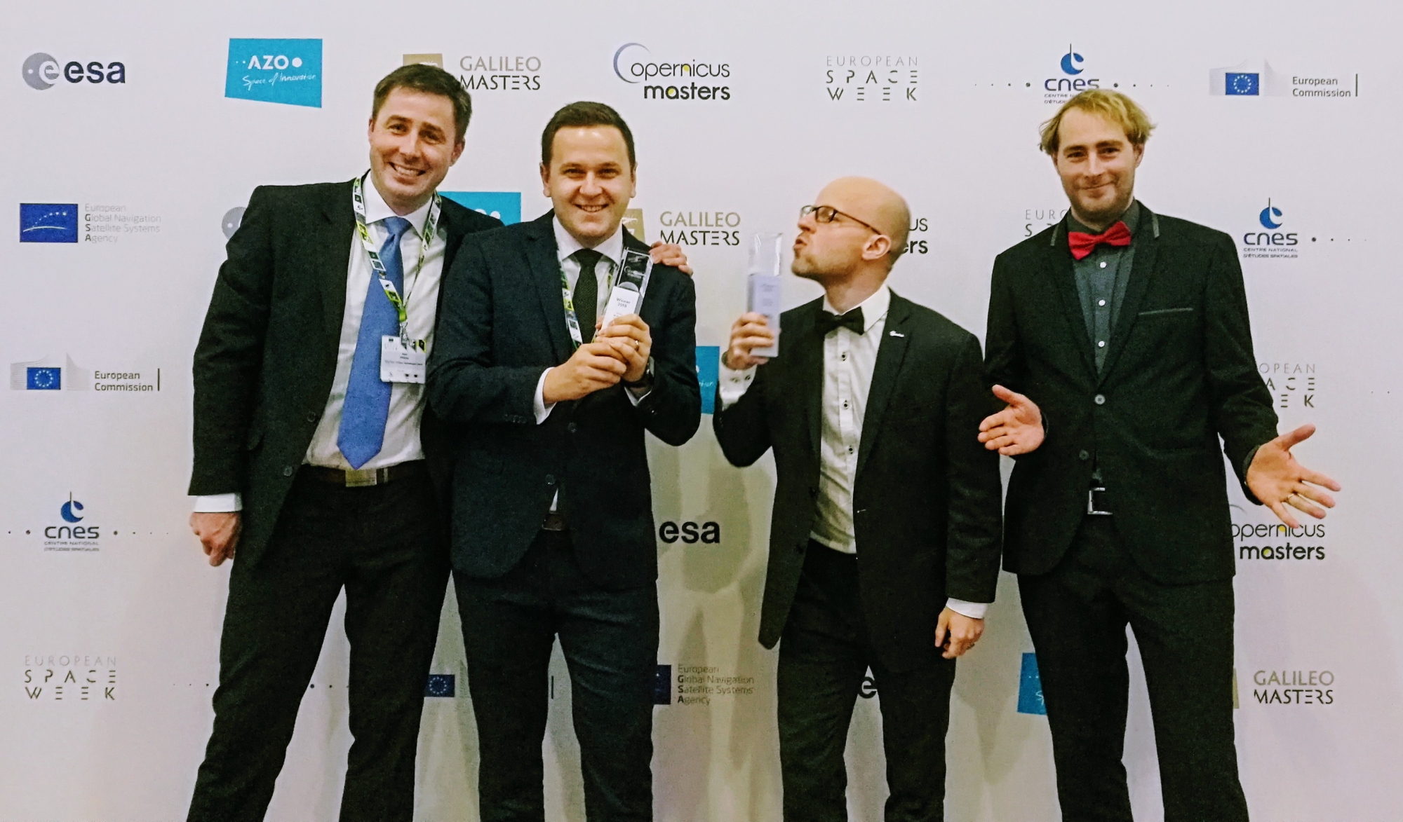
Česk-švýcarský startup MapTiler, který se specializuje na poskytování map a softwaru k jejich tvorbě, získal ocenění Evropské kosmické agentury. O jejich produktech, které by mohly nahradit Google Maps jsme psali v červnu. MapTiler cílí na globální trh a je používán společnostmi, jejichž mapy jsou skrz web či mobilní aplikace měsíčně zhlédnuty miliony návštěvníků. Za vývojem […]
The post MapTiler oceněn Evropskou kosmickou agenturou (TZ) appeared first on GISportal.cz.
UPOZORNĚNÍ
10.12.2018 8:05 ČÚZK - předpisy a opatření Katastrální úřad pro Ústecký kraj - Katastrální pracoviště Teplice zveřejnil novou aktualitu: Vážení klientiDne 31. 12. 2018 (pondělí) budou úřední hodiny Katastrálního pracoviště Teplice z provozních důvodů od 8:00 do 14:00 hodin. Děkujeme za pochopení a přejeme příjemné prožití vánočních svátků Katastrální úřad pro Ústecký kraj, Katastrální pracoviště Teplice
Oznámení o uzavření provozu Pobočky Domažlice
10.12.2018 0:00 Státní pozemkový úřad Z provozních důvodu (havárie vodovodu) bude v úterý 11. 12. 2018 uzavřena Pobočka Domažlice (KPÚ pro Plzeňský kraj).Vývoj rakety Ariane 6 úspěšně pokračuje
9.12.2018 23:02 Český Kosmický PortálUplynulý rok byl velmi intenzivní z hlediska vývoje nosiče Ariane 6. Pokrok je přitom viditelný napříč celou Evropou: továrny vyrábí nové díly za použití inovativních metod, došlo k otestování motorů všech stupňů a v plném proudu je stavba vypouštěcí rampy.
Poslední dny registrace na seminář Nemofora
9.12.2018 7:00 Česká asociace pro geoinformacePoslední dny registrace na seminář Nemofora
Poslední volná místa zbývají na seminář Využijeme šance vybudovat digitální mapu veřejné správy?, který pořádá Nemoforum ve spolupráci s ČÚZK, Ministerstvem vnitra a Českou asociací pro geoinformace. Seminář se uskuteční v pátek 18. října 2019 od 9:30 hodin v konferenčních prostorách Hotelu Akademie Naháč v