


![]()

zprávy
zdroje zpráv:Pasport komunikací
5.12.2016 1:00 Cenia - Katalog metadat ČR - INSPIRE Pasport komunikací zpracovaný firmou HaskoningDHV Czech Republic, s.r.o. pro potřeby města Chotěboř.Pasport obsahuje:Osy pozemních komunikací - liniePovrchy, kategorie, typy, třídy komunikací, vlastníky a správce komunikací - plochyBezbarierové prvky komunikací - linieOznačníky ulic - bodyNázvy ulic - linie s názvem ulice v databazové položceKanalizační vpusti - bodydalší veřejné služby
5.12.2016 1:00 Cenia - Katalog metadat ČR - INSPIRE data odvozená z ploch a koridorů Zásad územního rozvoje Ústeckého krajeprostorové rozlišení 1:100.000 (měřítko vydání ZÚRúdržba je vázána na vydávané aktualizace ZÚRpodmínky pro přístup a užití - bez omezeníomezení veřejného přístupu - bez omezeníinfrastruktura vodovodů a kanalizací
5.12.2016 1:00 Cenia - Katalog metadat ČR - INSPIRE data odvozená z ploch a koridorů Zásad územního rozvoje Ústeckého krajeprostorové rozlišení 1:100.000 (měřítko vydání ZÚRúdržba je vázána na vydávané aktualizace ZÚRpodmínky pro přístup a užití - bez omezeníomezení veřejného přístupu - bez omezeníOznámení o vyhlášení výběrového řízení na služební místo ředitel odboru personálního
5.12.2016 0:00 Státní pozemkový úřad Ústřední ředitelka Státního pozemkového úřadu, jako služební orgán příslušný podle § 10 odst. 1 písm. f) zákona č. 234/2014 Sb., o státní službě (dále jen „zákon“), vyhlašuje výběrové řízení.Pracovní nabídka – Liberec
4.12.2016 13:21 GISportal.cz Hledáte práci v Liberci? Magistrát zase hledá referenta oddělení územního plánování. Ještěd, sníh, krásné město, co víc si přát?Kurz managementu IPM-17
4.12.2016 11:41 Česká kosmická kancelář
Americká kosmická agentura NASA pořádá na konci února 2017 v Kennedyho kosmickém středisku na Floridě kurz zaměřený na řízení mezinárodních projektů v kosmonautice. Česká kosmická kancelář má příležitost na tento kurz nominovat jednoho účastníka z České republiky. Nominace je možné zasílat až 20. prosince 2016.
Výsledky ministerské rady ESA 2016 – ČR významně navýšila svoji účast ve volitelných programech!
3.12.2016 11:04 Český Kosmický PortálČeská delegace pod vedením náměstka ministra dopravy Kamila Rudoleckého úspěšně zakončila jednání na ministerské radě ESA, která se konala ve dnech 1. a 2. prosince 2016. V souladu se schváleným mandátem od vlády ČR významně navýšila svoji účast ve volitelných programech ESA. Podívejte se na rychlý přehled nových závazků ČR:
AECOsim Building Designer to read native Revit RVT files
2.12.2016 20:38 Bentley SystemsPress Coverage
AEC Magazine, UK
Read the articleodborný referent - poskytování informací KN, poskytování podkladů, nahlížení do KN, poskytování info
2.12.2016 16:21 ČÚZK /Urady/Katastralni-urady/Katastralni-urady/Katastralni-urad-pro-Zlinsky-kraj/Uredni-deska/Oznameni-a-jina-uredni-sdeleni/Volna-mista/odborny-referent-poskytovani-informaci-KN,-poskytoodborný referent - poskytování informací KN, poskytování podkladů, nahlížení do KN, poskytování info
2.12.2016 16:21 ČÚZK - předpisy a opatření Katastrální úřad pro Zlínský kraj Katastrální pracoviště Zlínvypisuje výběrové řízení na místo
odborný referent - poskytování informací KN, poskytování podkladů, nahlížení do KN, poskytování informací PK v oddělení dokumentace Katastrálního pracoviště Zlín
odborný referent - poskytování informací KN, poskytování podkladů, nahlížení do KN, poskytování info
2.12.2016 16:21 ČÚZK - volná místa Katastrální úřad pro Zlínský kraj, Katastrální pracoviště Zlín vypisuje výběrové řízení na místo odborný referent - poskytování informací KN, poskytování podkladů, nahlížení do KN, poskytování infovrchní referent / rada – obnova katastrálního operátu v oddělení dokumentace KN Katastrálního pracov
2.12.2016 16:03 ČÚZK - volná místa Katastrální úřad pro Zlínský kraj, Katastrální pracoviště Uherský Brod vypisuje výběrové řízení na místo vrchní referent / rada – obnova katastrálního operátu v oddělení dokumentace KN Katastrálního pracovvrchní referent / rada – obnova katastrálního operátu v oddělení dokumentace KN Katastrálního pracov
2.12.2016 16:03 ČÚZK /Urady/Katastralni-urady/Katastralni-urady/Katastralni-urad-pro-Zlinsky-kraj/Uredni-deska/Oznameni-a-jina-uredni-sdeleni/Volna-mista/vrchni-referent-rada-–-obnova-katastralniho-op-(2)vrchní referent / rada – obnova katastrálního operátu v oddělení dokumentace KN Katastrálního pracov
2.12.2016 16:03 ČÚZK - předpisy a opatření Katastrální úřad pro Zlínský kraj Katastrální pracoviště Uherský Brodvypisuje výběrové řízení na místo
vrchní referent / rada – obnova katastrálního operátu v oddělení dokumentace KN Katastrálního pracoviště Uherský Brod
rada / odborný rada – rozhodování o povolení vkladu v oddělení právních vztahů k nemovitostem Katast
2.12.2016 15:56 ČÚZK /Urady/Katastralni-urady/Katastralni-urady/Katastralni-urad-pro-Zlinsky-kraj/Uredni-deska/Oznameni-a-jina-uredni-sdeleni/Volna-mista/rada-odborny-rada-–-rozhodovani-o-povoleni-vkladurada / odborný rada – rozhodování o povolení vkladu v oddělení právních vztahů k nemovitostem Katast
2.12.2016 15:56 ČÚZK - volná místa Katastrální úřad pro Zlínský kraj, Katastrální pracoviště Holešov vypisuje výběrové řízení na místo rada / odborný rada – rozhodování o povolení vkladu v oddělení právních vztahů k nemovitostem Katastrada / odborný rada – rozhodování o povolení vkladu v oddělení právních vztahů k nemovitostem Katast
2.12.2016 15:56 ČÚZK - předpisy a opatření Katastrální úřad pro Zlínský kraj Katastrální pracoviště Holešovvypisuje výběrové řízení na místo
rada / odborný rada – rozhodování o povolení vkladu v oddělení právních vztahů k nemovitostem Katastrálního pracoviště Holešov
NEJinovátor JMK – TopGis mezi oceněnými
2.12.2016 14:55 TopGis Že kráčíme správným směrem potvrzují i výsledky letošní soutěže NEJinovátor Jihomoravského kraje, kde jsme byli oceněni jako skokan roku! Nej desítku už máme na dosah. Ceny přebrala Drahomíra Zedníčková, CEO TopGis. Děkujeme všem kolegům, naše soukolí funguje výborně. Oficiální tiskovou zprávu organizátorů najdete zde.V Geoportálu ÚAP Ústeckého kra
2.12.2016 12:00 Ústecký kraj V Geoportálu ÚAP Ústeckého kraje byla provedena aktualizace údajů pro poskytovatele Ministerstvo obrany – jev 44, 67, 68, 69, 70, 72, 73, 74, 75, 79, 80, 81, 82, 93, 97, 102, 103, 107, 108, 114, 119, Agentura ochrany přírody a krajiny České republiky – jev 28, 29, 30, a ČEPS, a.s. – jev 72, 73V prostředí Geoportálu je již
2.12.2016 12:00 Ústecký kraj V prostředí Geoportálu je již vše funkční (jak mapové aplikace tak výdejní modul pro data ÚAP) .Záznam přednášky o GIS města Brna
2.12.2016 11:53 T-MAPY Byli jste na Konferenci GIS Esri 2016 v ČR? Viděli jste přednášku Dany Glosové z Magistrátu města Brna o směřování jejich geoinformačního systému? Ne? Tak se podívejte, jaký GIS pro Brno spoluvytváříme.GIS města Brna prošel během svého budování mnoha milníky a změnami a postupně se vyvinul z něčeho na okraji zájmu v nepostradatelný základ městského informačního systému. O tom, jakým vývojem prochází, přednášela vedoucí oddělení GIS Dana Glosová na Konferenci GIS Esri 2016 v ČR.Zmínila oceněný projekt Digitální mapa Brna, ukázala příklady starších i zcela nových aplikací a představila základ nového geoportálu. Především se ale soustředila na budoucnost a na to, jakým směrem chce Brno společně s námi GIS dále rozvíjet. A také na to, proč už tomu nechceme říkat GIS, ale GeoHub. GeoHub jako Brno.Nordic entrepreneurial spirit boosted by space
2.12.2016 11:50 ESA Observing the Earth
More than 17 000 people converged on Helsinki in Finland this week to create businesses – and ESA was there to add its space expertise.
Nordic entrepreneurial spirit boosted by space
2.12.2016 11:50 ESA Observing the EarthMore than 17 000 people converged on Helsinki in Finland this week to create businesses – and ESA was there to add its space expertise.
Rada / odborný rada – rozhodování o povolení vkladu v oddělení právních vztahů k nemovitostem
2.12.2016 11:47 ČÚZK - volná místa Katastrální úřad pro Liberecký kraj, Katastrální pracoviště Semily vypisuje výběrové řízení na místo Rada / odborný rada – rozhodování o povolení vkladu v oddělení právních vztahů k nemovitostemRada / odborný rada – rozhodování o povolení vkladu v oddělení právních vztahů k nemovitostem
2.12.2016 11:47 ČÚZK /Urady/Katastralni-urady/Katastralni-urady/Katastralni-urad-pro-Liberecky-kraj/Uredni-deska/Oznameni-a-jina-uredni-sdeleni/Volna-mista/Rada-odborny-rada-–-rozhodovani-o-povoleni-vkl-(1)Rada / odborný rada – rozhodování o povolení vkladu v oddělení právních vztahů k nemovitostem
2.12.2016 11:47 ČÚZK - předpisy a opatření Katastrální úřad pro Liberecký kraj Katastrální pracoviště Semilyvypisuje výběrové řízení na místo
Rada / odborný rada – rozhodování o povolení vkladu v oddělení právních vztahů k nemovitostem
Termíny školení pro rok 2017
2.12.2016 11:27 ARCDATAPřijďte si zdokonalit své schopnosti a načerpat nové zkušenosti na naše školení.
Na webových stránkách školení naleznete termíny až do konce června 2017. Vybrat si můžete z téměř dvaceti kurzů včetně zcela nového Nasazení Portal for ArcGIS. Toto dvoudenní školení se věnuje optimálním postupům nasazení a konfigurace Portal for ArcGIS v organizaci.

Číslo účtu na zálohové faktuře
2.12.2016 10:12 Zeměměřič v čísle Zeměměřiče 11+12/2016 zakrýval z části obrázek obálky časopisu.Switzerland
2.12.2016 10:05 ESA Observing the Earth
Earth observation image of the week: explore Switzerland at 10 m resolution with Sentinel-2, also featured on the Earth from Space video programme
Záznam přednášky o GIS města Brna
2.12.2016 9:50 T-MAPY Byli jste na Konferenci GIS Esri 2016 v ČR? Viděli jste přednášku D. Glosové z Magistrátu města Brna o směřování jejich geoinformačního systému? Ne? Tak se podívejte, jaký GIS pro Brno spoluvytváříme.Zajímavé video vyvětlující INSPIRE
2.12.2016 9:26 Blogující geomatici - FAV ZČU Při dnešní přípravě přednášky na pondělní TGI jsem narazil na zajímavé video, vysvětlující o čem je směrnice INSPIRE.Video pochází přímo z INSPIRE portálu. Doporučuji tedy ke shlédnutí všem, kromě studentů TGI !-)
Kupujte náš nástěnný kalendář Česko mezi oblaky pro rok 2017
2.12.2016 9:23 UpVision Je tu prosinec a kdo by sháněl drobný dárek, tak pro ty je v prodeji náš kalendář Česko mezi oblaky na rok 2017. :-)V současné chvíli je už vyprodán, ale každým dnem by měl být opět dostupný na této stránce nebo u dalších distributorských firem v kontaktech této stránky.
http://www.helma365.eu/produkt-cesko-mezi-oblaky-22
EGNOS earns new distinction
2.12.2016 9:05 European GNSS Agency
France’s Air and Space Academy recognises EGNOS for its significant contribution to European space.
The European Geostationary Navigation Overlay Service (EGNOS) was recently recognised by France’s Air and Space Academy (AAE). In honour of its significant scientific and technical contribution to European space, EGNOS was awarded the AAE’s Vermeil Medal during its 25 November 2016 plenary session in Toulouse. The medal is awarded annually to an individual or organisation that has achieved international notoriety in the field of aerospace.
“I’m pleased to share this distinction with the EGNOS team and the entire GSA, which has dedicated many years to the success of this programme,” says GSA EGNOS Exploitation Programme Manager Jean-Marc Piéplu. “Many of my colleagues have personally contributed to the development of EGNOS, and this medal belongs to all of them.”
Also read: EGNOS lays the foundation for Galileo
Joining Jean-Marc in receiving the award was European Space Agency (ESA) Head of EGNOS and SBAS Division Didier Flament and ENAIRE (Spain’s air navigation management organisation) Head of International Affairs and SESAR Coordinator Mariluz de Mateo.
EGNOS also played a role in this year’s Great Prize winner, which went to the EGNOS-equipped Airbus A350-XWB.
About the AAE
Founded in 1983 in Toulouse, the AAE encourages the development of high quality scientific, technical, cultural and human actions in both air and space. To do so, it promotes knowledge sharing across the industry and serves as a focal point for aerospace activities. Its members – who come from all walks of aerospace life and include pilots, astronauts, scientists, engineers, doctors, manufactures, economists, lawyers and artists from France and Europe – work together to achieve these essential goals.
Media note: This feature can be republished without charge provided the European GNSS Agency (GSA) is acknowledged as the source at the top or the bottom of the story. You must request permission before you use any of the photographs on the site. If you republish, we would be grateful if you could link back to the GSA website (http://www.gsa.europa.eu).
EGNOS team receive prestigious award
2.12.2016 8:58 ESA Navigation
The multi-agency team behind the ESA-designed EGNOS augmentation system – making it possible for European aircraft to safely rely on satnav signals – has received a prestigious award from France’s national aerospace academy.
3D model Prahy na webu
2.12.2016 7:00 Česká asociace pro geoinformaceNová aplikace z dílny Institutu plánování a rozvoje Prahy (IPR Praha) umožňuje prohlídnout si celou Prahu ve 3D. Aplikace obsahuje i širokou škálu podrobných informací o každém objektu: zobrazit umí počet podlaží, ale třeba i vlastnické vztahy. 3D model tvoří více než 200 000 budov.
V aplikaci je možné vyhledávat podle adresy. Dům, který hledáte, se v mapě
Společně otevíráme data - vyhlášení
2.12.2016 7:00 Česká asociace pro geoinformace Vyhlášení soutěže Společně otevíráme data proběhne 21. listopadu 2017 od 19:00 v Praze (Dlouhá 37). Do konce října je stále ještě možné přihlásit svoji aplikaci postavenou nad otevřenými daty do soutěže!Soutěž je otevřena všem zájemcům z řad studenstva, veřejnosti, neziskových organizací i firem. Základní podmínkou je, aby přihlášené aplikace využívaly
Prohlížecí služba WMS pro Územní jednotky (UX)
2.12.2016 1:00 Cenia - Katalog metadat ČR - INSPIRE Prohlížecí služba WMS pro téma Units eXtended (UX) je veřejná prohlížecí služba pro poskytování dat týkajících se jednotek spravovaných resortem ČÚZK. Jedná se o neharmonizované rozšíření INSPIRE tématu Územní správní jednotky o evidenční, statistické a historické jednotky. Služba je dostupná na celém území České republiky. Služba splňuje technické pokyny pro INSPIRE prohlížeci služby ve verzi 3.11 a zároveň standardy OGC WMS 1.1.1 a 1.3.0.Speciální datová sada RÚIAN s číselníky ve formátu VFR
2.12.2016 1:00 Cenia - Katalog metadat ČR - INSPIRE Data vychází z Registru územní identifikace, adres a nemovitostí (RÚIAN), který je součástí základních registrů České republiky a obsahuje informace o územní identifikaci, adresách a nemovitostech. Data jsou poskytována ve výměnném formátu RÚIAN (VFR), ve kterém jsou zapsána jazykem XML a odpovídají formátu GML 3.2.1 (podle ISO 19136:2007). Pro stažení jsou datové sady komprimovány jako archivy Gzip. Stavový soubor s číselníky se generuje vždy aktuální k třetímu dni v měsíci a skládá se z elementů: Kod, Nazev, Zkratka, Popis, ZacatekPlatnosti, KonecPlatnosti. Obsahem souboru je číselník typů prvků, územních prvků a územně evidenčních jednotek a dále číselníky používané pro zápis údajů u některých prvků: stavební objekt (druhy konstrukcí, připojení ke kanalizaci, připojení k rozvodu plynu, připojení k vodovodu, vybavení, výtahem, způsoby vytápění, způsoby využití, typy), ZSJ (charaktery ZSJ), obec (statusy), MOMC (rozsahy členění na MOMC, typy členění na MOMC), parcela (BPEJ, druhy číslování, druhy pozemku, způsoby využití pozemku, typ ochrany pozemku, způsob ochrany pozemku) a adresní místo (adresní pošty).Speciální datová sada RÚIAN s volebními okrsky ve formátu VFR
2.12.2016 1:00 Cenia - Katalog metadat ČR - INSPIRE Data vychází z Registru územní identifikace, adres a nemovitostí (RÚIAN), který je součástí základních registrů České republiky a obsahuje informace o územní identifikaci, adresách a nemovitostech. Data jsou poskytována ve výměnném formátu RÚIAN (VFR), ve kterém jsou zapsána jazykem XML a odpovídají formátu GML 3.2.1 (podle ISO 19136:2007). Pro stažení jsou datové sady komprimovány jako archivy Gzip. Stavový soubor s volebními okrsky se generuje vždy aktuální k třetímu dni každého měsíce. Volební okrsky jsou účelovým územním prvkem vedeným v RÚIAN a jsou beze zbytku skladebné do území obcí, resp. území městských částí/městských obvodů (MOMC) územně členěných statutárních měst a tím odvozeně do území celé ČR. Soubor obsahuje všechny volební okrsky a jejich atributy: kód, definiční bod, hranice, platnost, kód obce, kód MOMC a ID návrhu změny, kterým byl volební okrsek naposledy změněn.Vybraná data RÚIAN poskytovaná pro stát ve formátu SHP
2.12.2016 1:00 Cenia - Katalog metadat ČR - INSPIRE V těchto SHP jsou poskytována vybraná data z RÚIAN. Konkrétně se jedná o polygony: státu, vyšších územně samosprávních celků (VÚSC), regionů soudržnosti, obcí s pověřeným obecním úřadem (POÚ), obcí s rozšířenou působností (ORP), okresů, obcí a vojenských újezdů, katastrálních území a volebních okrsků. Soubory jsou aktualizované 1x denně. Soubory jsou k dispozici za stát.Prohlížecí služba WMS pro Digitalizaci katastrální mapy (DG)
2.12.2016 1:00 Cenia - Katalog metadat ČR - INSPIRE Prohlížecí služba (WMS) znázorňující stav a postup digitalizace katastrálních území, přehled kladu mapových listů a území s analogovou/vektorovou katastrální mapou. Služba splňuje standard OGC WMS 1.3.0.ArcČR 500 ver. 3.2
2.12.2016 1:00 Cenia - Katalog metadat ČR - INSPIRE ArcČR 500 je digitální vektorová geografická databáze České republiky, zpracována na úrovni podrobnosti 1 : 500 000. Navazuje na podobné databáze, zpracované firmou Esri. Obsahem databáze jsou přehledné geografické informace o ČR. Databáze obsahuje základní geografické prvky jako jsou vodstvo, lesy, sídla, doprava, administrativní jednotky (obce, městské části a obvody, okresy, kraje) a klady listů státních mapových děl v měřítku 1 : 500 000. Data umožňují široké spektrum prostorových analýz a vizualizace a poskytují možnost propojení na statistická data.Volební okrsky
2.12.2016 1:00 Cenia - Katalog metadat ČR - INSPIRE Seznam adresních míst a jejich příslušnost k volebním okrskům. Adresní místa jsou členěna po obcích a městkých obvodech městských částí.Sídla Evropy (2015)
2.12.2016 1:00 Cenia - Katalog metadat ČR - INSPIRE Převzatá datová sada evropských sídel (EU, Island, Norsko, Švýcarsko) ze série dat Eurostatu Urban Audit doplněná o hlavní města okolních zemí pro potřeby metadatového katalogu NGI.Úvodní jednání pro komplexní pozemkovou úpravu v katastrálním území Lety
2.12.2016 0:00 Státní pozemkový úřadOznámení o vyhlášení výběrového řízení na služební místo odborný rada sekce řízení krajských pozemkových úřadů a pozemkových úprav
2.12.2016 0:00 Státní pozemkový úřad Ústřední ředitelka Státního pozemkového úřadu, jako služební orgán příslušný podle § 10 odst. 1 písm. f) zákona č. 234/2014 Sb., o státní službě (dále jen „zákon“), vyhlašuje výběrové řízení.Oznámení o vyhlášení výběrového řízení na služební místo vedoucí oddělení převodu majetku státu, Krajský pozemkový úřad pro Karlovarský kraj
2.12.2016 0:00 Státní pozemkový úřad Ústřední ředitelka Státního pozemkového úřadu, jako služební orgán příslušný podle § 10 odst. 1 písm. f) zákona č. 234/2014 Sb., o státní službě (dále jen „zákon“), vyhlašuje výběrové řízení.Oznámení o vyhlášení výběrového řízení na služební místo vrchní referent / rada oddělení správy majetku státu, Krajský pozemkový úřad pro Ústecký kraj
2.12.2016 0:00 Státní pozemkový úřad Ústřední ředitelka Státního pozemkového úřadu, jako služební orgán příslušný podle § 10 odst. 1 písm. f) zákona č. 234/2014 Sb., o státní službě (dále jen „zákon“), vyhlašuje výběrové řízení.INTERVIEW – Jeremy Shaffer and Mike Coldrick
1.12.2016 20:40 Bentley SystemsPress Coverage
Rail Professional
Read the articleCampus Revitalization
1.12.2016 20:19 Bentley SystemsPress Coverage
Informed Infrastructure
Read the articleZáznam přednášky o GIS města Brna
1.12.2016 16:33 T-MAPY Byli jste na Konferenci GIS Esri 2016? Viděli jste přednášku Dany Glosové z Magistrátu města Brna o vývoji jejich geoinformačního systému? Ne? Naleznete ji na YouTube na této adrese. Samotnou prezentaci ve formátu pdf pak naleznete zde.Sharing Earth observation satellite data to help understand our planet
1.12.2016 15:30 ESA Observing the Earth
Since the launch of the first Earth-observing satellites in the 1970s, numerous missions from international space organisations have taken to the sky. Today, decades of data are helping scientists to build a better picture of changes to our planet.
Earth from Space
1.12.2016 14:45 ESA Observing the Earth
Join us Friday, 2 December, at 10:00 CET for the ‘Earth from Space’ video programme. This week, take a tour of Switzerland with Sentinel-2
Earth from Space
1.12.2016 14:00 ESA Observing the EarthJoin us Friday, 2 December, at 10:00 CET for the ‘Earth from Space’ video programme. This week, take a tour of Switzerland with Sentinel-2
Výzva sekretariátu katedry k zadáním DP a BP
1.12.2016 11:12 Katedra geografie UP Olomouc Studenti, kteří odevzdali přihlášku k zadání kvalifikační práce na sekretariátě katedry, mají u paní sekretářky připravena oficiální zadání prací, které je třeba si vyzvednout a uschovat (bude povinnou součástí odevzdávané práce). Učiňte tak prosíme co nejdříve.Jmenovitě pak vyzýváme studenty, jejichž zadání čeká na vyzvednutí už delší dobu, aby se také bez dalšího odkladu dostavili pro jeho vyzvednutí na sekretariát:
DP: Balatková Dominika, Boháč Filip, Drlík Karel, Fujáková Petra, Kačírek Matěj, Koutná Barbora, Majerová Michaela, Malčánek Jan, Nosková Dagmar, Polášek Rudolf, Pulkrábková Veronika, Regecová Natália, Šafář Roman
BP: Boudová Kateřina, Dubovec Patrik, Hájek Václav, Hanulík Pavel, Kovář Jakub, Malíková Michaela, Mézlová Jarmila, Pecháčková Veronika, Šmíd Ondřej, Tokar Vladimír, Tomášová Zuzana, Zajíček Petr
Mimořádný přesun konzultačních hodin dr. Šimáčka
1.12.2016 10:23 Katedra geografie UP Olomouc V úterý 6. prosince 2016 budou konzultační hodiny dr. Šimáčka mimořádně přesunuty na čas od 9.15 do 11.15 z důvodu jeho nepřítomnosti v odpoledních hodinách.Geodet/ka
1.12.2016 9:27 ČÚZK - volná místa Zeměměřický úřad, vypisuje výběrové řízení na místo Geodet/kaGeodet/ka
1.12.2016 9:27 Zeměměřický úřad Zeměměřický úřadvypisuje výběrové řízení na místo
Geodet/ka
GNSS mobile apps: using Nougat to access raw GNSS measurements
1.12.2016 9:25 European GNSS Agency
The ability to access raw GNSS measurements opens up a range of opportunities for mobile app developers, but how do you access the data? During the first European GNSS Agency (GSA) Galileo Hackathon at the WhereCamp ‘unconference’ in Berlin Dr Lukasz Bonenberg from the University of Nottingham explained how app-developers can access raw GNSS measurements on smartphones via the latest release of the Android operating system.
The technical briefing for app-developers at the first GSA Hackathon at Beuth Hochschule für Technik in Berlin covered the latest developments and opportunities for GNSS and Location Based Services (LBS) including both hardware and software.
The hardware that the hackers used in the Hackathon - the Galileo-enabled BQ Aquaris X5 Plus Android smartphone - was described by Alvaro Fructuoso and Olaja Segura from the phone’s manufacturer. At the heart of the phone is the Qualcomm Snapdragon 652 chip that provides a true multi-constellation GNSS experience.
Digging down in Nougat
The next generation of Android operating system (7.0) is named Nougat and allows access to GNSS raw measurements using a new version of Google’s application programme interfaces (APIs) that give more flexible and deeper access to positioning data. Dr Lukasz Bonenberg from the University of Nottingham opened up the ‘black box’ that is the modern smartphone and shed some light on where hackers and coders needed to look to get access to this data.
Currently, location in Android is accessed via Google Play Services GMS Location providing activity and location awareness that can be easily harnessed by coders to provide enhanced location data (e.g. geofencing, near services etc.) for their apps. New Android Nougat (API v24) adds extra capacities. It directly accesses sensor data via android.location. This data has previously been hidden away in physical drivers, but access now opens up possibilities for higher accuracy and deployment of algorithms currently restricted to more advanced GNSS receivers.
While access to the raw data becomes easier, its use is still a challenging task. The key to reading GNSS measurements is the synching of clocks between the phone and the GNSS satellites to give pseudoranges – effectively the distance from the phone to the satellite degraded by the clock errors. To get an accurate and reliable fix requires signals – and therefore calculated pseudoranges - from at least four GNSS satellites, explained Bonenberg.
MatLab codes
To support this Google has released the MatLlab code demonstrating both the data collection (GNSS data logger application) as well as calculation details for obtaining observations and calculating position. To further support the development community, Bonenberg is developing a version of the processing code in the Python programming language. It is available at his GitHub together with his edits to the original Google MatLab code.
“The ability to access raw data opens up a range of possibilities and opportunities,” claimed Bonenberg. These comprise the use of external corrections including existing differential-GNSS and augmentations services such as EGNOS for high precision. More opportunities come with advanced algorithms to reduce errors in urban areas by, for example, removing satellites that are blocked by buildings from the positioning calculation, and the ability to fuse GNSS data with data from other phone based sensors such as the Inertial Measurement Unit (IMU).
Work is also carried out using carrier phase measurements offering even better positional performance. Not only do these developments promise improved accuracy, availability and reliability or data fusion for mass market applications, but also the ability to use those devices in the domains currently reserved for much more expensive and dedicated GNSS receivers Bonenberg concluded.
“The ability to access GNSS raw data on Android devices opens up a range of possibilities and opportunities.”
More information:
WhereCamp
Android Developers: Location
Lukasz Bonenberg’s GitHub on Android GNSS
Media note: This feature can be republished without charge provided the European GNSS Agency (GSA) is acknowledged as the source at the top or the bottom of the story. You must request permission before you use any of the photographs on the site. If you republish, we would be grateful if you could link back to the GSA website (http://www.gsa.europa.eu).
První družice SmallGEO absolvovala svoji poslední pozemskou cestu
1.12.2016 8:24 Český Kosmický PortálPrvní telekomunikační družice postavená na platformě SmallGEO dnes po dokončení testů v německé firmě IABG dorazila na evropský kosmodrom Kourou (stát Francouzská Guayana). Vstoupila tak do závěrečné fáze přípravy, která směřuje ke startu na palubě rakety Sojuz v lednu příštího roku.
Využití území odvozené ze ZÚR JČK - letecká doprava
1.12.2016 1:00 Cenia - Katalog metadat ČR - INSPIRE letecká dopravaVyužití území odvozené ze ZÚR JČK - výroba jaderné energie
1.12.2016 1:00 Cenia - Katalog metadat ČR - INSPIRE výroba jaderné energieVyužití území odvozené ze ZÚR JČK - silniční doprava
1.12.2016 1:00 Cenia - Katalog metadat ČR - INSPIRE silniční dopravaVyužití území odvozené ze ZÚR JČK - výroba energie z obnovitelných zdrojů
1.12.2016 1:00 Cenia - Katalog metadat ČR - INSPIRE výroba energie z obnovitelných zdrojůVyužití území na základě dat ZÚR Jihočeského kraje - série dat
1.12.2016 1:00 Cenia - Katalog metadat ČR - INSPIRE Souhrn datových sad pro službu Využití dat ze ZÚR. Využití vrstvy: VyuzitiZUR_0_plochy_bez_specif; plochy, jejichž plánované využití není specifikovánoVyuzitiZUR_1_opustene_plochy; opuštěné plochyVyuzitiZUR_2_sportovni_infrastruktura sportovní infrastrukturaVyuzitiZUR_3_energ_obn_zdroje; výroba energie z obnovitelných zdrojůVyuzitiZUR_4_energ_jaderna; výroba jaderné energieVyuzitiZUR_5_terciárni_produkce; terciární produkceVyuzitiZUR_6_tezba_dobyvani; těžba a dobýváníVyuzitiZUR_7_prir_bez_hosp_vyuz; přírodní plochy, které nejsou jinak hospodářsky využíványVyuzitiZUR_8_voda_kanal; infrastruktura vodovodů a kanalizacíVyuzitiZUR_9_energ_rozvody; služby v oblasti rozvodu elektřiny, plynu a tepelné energieVyuzitiZUR_10_jina_doprava; jiná dopravní síťVyuzitiZUR_11_logistika_sklad; logistické a skladovací službyVyuzitiZUR_12_doprava_voda; vodní dopravaVyuzitiZUR_13_doprava_letecka; letecká dopravaVyuzitiZUR_14_doprava_zeleznice; kolejová dopravaVyuzitiZUR_15_doprava_silnicni; silniční dopravaVyuzitiZUR_16_dalsi_ver_sluzby; další veřejné službyVyužití území odvozené ze ZÚR JČK - kolejová doprava
1.12.2016 1:00 Cenia - Katalog metadat ČR - INSPIRE kolejová dopravaVyužití území odvozené ze ZÚR JČK - plochy, jejichž plánované využití není specifikováno
1.12.2016 1:00 Cenia - Katalog metadat ČR - INSPIRE plochy, jejichž plánované využití není specifikovánoVyužití území odvozené ze ZÚR JČK - infrastruktura vodovodů a kanalizací
1.12.2016 1:00 Cenia - Katalog metadat ČR - INSPIRE infrastruktura vodovodů a kanalizacíVyužití území odvozené ze ZÚR JČK - přírodní plochy, které nejsou jinak hospodářsky využívány
1.12.2016 1:00 Cenia - Katalog metadat ČR - INSPIRE přírodní plochy, které nejsou jinak hospodářsky využíványAdministrativní hranice států světa (2013)
1.12.2016 1:00 Cenia - Katalog metadat ČR - INSPIRE Administrativní hranice států světa z databáze EuroGeographics pro rok 2013.Využití území odvozené ze ZÚR JČK - vodní doprava
1.12.2016 1:00 Cenia - Katalog metadat ČR - INSPIRE vodní dopravaVyužití území odvozené ze ZÚR JČK - WFS
1.12.2016 1:00 Cenia - Katalog metadat ČR - INSPIRE Využití území na základě dat ZÚR Jihočeského krajeZáplavová území
1.12.2016 1:00 Cenia - Katalog metadat ČR - INSPIRE Záplavová území - Q100, Q20, Q5, aktivní zóny, hlásné profily, Pravidelně aktualizované v případě změn - nabytí právní moci opatření obecné povahy o stanovení záplavového území a vymezení aktivní zóny. Poslední aktualizace 11/2016.Využití území odvozené ze ZÚR JČK - jiná dopravní síť
1.12.2016 1:00 Cenia - Katalog metadat ČR - INSPIRE jiná dopravní síťVyužití území odvozené ze ZÚR JČK - sportovní infrastruktura
1.12.2016 1:00 Cenia - Katalog metadat ČR - INSPIRE sportovní infrastrukturaVyužití území odvozené ze ZÚR JČK - logistické a skladovací služby
1.12.2016 1:00 Cenia - Katalog metadat ČR - INSPIRE logistické a skladovací službyVyužití území odvozené ze ZÚR JČK - terciární produkce
1.12.2016 1:00 Cenia - Katalog metadat ČR - INSPIRE terciární produkceVyužití území odvozené ze ZÚR JČK - další veřejné služby
1.12.2016 1:00 Cenia - Katalog metadat ČR - INSPIRE další veřejné službyVyužití území odvozené ze ZÚR JČK - těžba a dobývání
1.12.2016 1:00 Cenia - Katalog metadat ČR - INSPIRE těžba a dobýváníSoučasná změnová data RÚIAN v základní datové sadě poskytovaná po obcích ve formátu VFR
1.12.2016 1:00 Cenia - Katalog metadat ČR - INSPIRE Data vychází z Registru územní identifikace, adres a nemovitostí (RÚIAN), který je součástí základních registrů České republiky a obsahuje informace o územní identifikaci, adresách a nemovitostech. Data jsou poskytována ve výměnném formátu RÚIAN (VFR), ve kterém jsou zapsána jazykem XML a odpovídají formátu GML 3.2.1 (podle ISO 19136:2007). Pro stažení jsou datové sady komprimovány jako archivy Gzip. Datová sada je generována pro každý den a obsahuje aktuální údaje prvků RÚIAN u kterých došlo v daném dni ke změně alespoň jednoho jejich atributu. Datová sada obsahuje změněné prvky RÚIAN za celou ČR. Konkrétně se jedná o prvky: stát, kraj 1960, okres, region soudržnosti, VÚSC, ORP, POU, obec, část obce, správní obvod Prahy (SOP), městský obvod Prahy (MOP), městská část/městský obvod (MOMC), katastrální území, ZSJ, parcela, stavební objekt, ulice a adresní místo. Pro prvky obsažené v základní datové sadě jsou uvedeny textové (popisné) údaje územních prvků a územně evidenčních jednotek a jejich definiční body.Využití území odvozené ze ZÚR JČK - služby v oblasti rozvodu elektřiny, plynu a tepelné energie
1.12.2016 1:00 Cenia - Katalog metadat ČR - INSPIRE služby v oblasti rozvodu elektřiny, plynu a tepelné energieAdministrativní členění Evropy - NUTS (2013)
1.12.2016 1:00 Cenia - Katalog metadat ČR - INSPIRE Administrativní členění regionů Evropské unie na úrovni NUTS 0, 1, 2 a 3. Nomenklatura NUTS je hierarchická klasifikace statistických oblastí a rozdělující hospodářské území EU. Klasifikace NUTS byla vychází z nařízení (ES) č. 1059/2003 Evropského parlamentu a Rady.Využití území odvozené ze ZÚR JČK - opuštěné plochy
1.12.2016 1:00 Cenia - Katalog metadat ČR - INSPIRE opuštěné plochyBentley Year in Infrastructure 2016 CEO address
30.11.2016 21:42 Bentley SystemsPress Coverage
Renewable Energy World
Read the articleReality modeling goes mainstream at Bentley's Year in Infrastructure conference. #YII2016
30.11.2016 21:40 Bentley SystemsPress Coverage
Renewable Energy World
Read the articleLive from the Bentley #YII2016 Technology Keynote in London
30.11.2016 21:38 Bentley SystemsPress Coverage
Renewable Energy World
Read the articleAnd we're back! #YII2016 Bentley Technology Keynote
30.11.2016 21:35 Bentley SystemsPress Coverage
Renewable Energy World
Read the articleModern intelligent inspection with Bentley
30.11.2016 21:33 Bentley SystemsPress Coverage
Renewable Energy World
Read the articleMedabil Streamlines Geometric Design of Wtorre Morumbi with BIM Advancements
30.11.2016 20:59 Bentley SystemsPress Coverage
Construction and Architecture Update
Read the articleBentley's Structural Design software helps decrease construction time
30.11.2016 20:55 Bentley SystemsPress Coverage
Buildotech
Read the articleFocusing on Life Assets for Future
30.11.2016 20:50 Bentley SystemsPress Coverage
Oil Asia
Read the articleMore Projects, Bigger Projects, Done More Frequently: Photo Capture is Another Big Leap for Survey Technology
30.11.2016 20:44 Bentley SystemsPress Coverage
Directions Magazine
Read the articleBentley Systems Contributes to Crossrail Success
30.11.2016 20:31 Bentley SystemsPress Coverage
The Singapore Engineer
Read the articleOn a high
30.11.2016 20:28 Bentley SystemsPress Coverage
Architects and Interiors India
Read the articleAECOM Designs the New Dholera Sustainable Smart City in India Using BIM Processes
30.11.2016 20:20 Bentley SystemsPress Coverage
MicroStation Connections
Read the articleMore Projects, Bigger Projects, Done More Frequently: Photo Capture is Another Big Leap for Survey Technology
30.11.2016 16:55 Bentley SystemsPress Coverage
Directions Magazine
Read the articlevrchní referent/rada v oddělení obnovy katastrální operátu a revize KN
30.11.2016 14:13 ČÚZK - předpisy a opatření Katastrální úřad pro Jihomoravský kraj Katastrální pracoviště Brno-venkovnabízí dvě služební místa
vrchní referent/rada v oddělení obnovy katastrální operátu a revize KN
vrchní referent/rada v oddělení obnovy katastrální operátu a revize KN
30.11.2016 14:13 ČÚZK - volná místa Katastrální úřad pro Jihomoravský kraj, Katastrální pracoviště Brno-venkov vypisuje výběrové řízení na místo vrchní referent/rada v oddělení obnovy katastrální operátu a revize KNvrchní referent/rada v oddělení obnovy katastrální operátu a revize KN
30.11.2016 14:13 ČÚZK /Urady/Katastralni-urady/Katastralni-urady/Katastralni-urad-pro-Jihomoravsky-kraj/Uredni-deska/Oznameni-a-jina-uredni-sdeleni/Volna-mista/vrchni-referent-rada-v-oddeleni-obnovy-katastr-(1)odborný referent v oddělení právních vztahů k nemovitostem Katastrálního pracoviště Svitavy
30.11.2016 14:06 ČÚZK - volná místa Katastrální úřad pro Pardubický kraj, Katastrální pracoviště Svitavy vypisuje výběrové řízení na místo odborný referent v oddělení právních vztahů k nemovitostem Katastrálního pracoviště Svitavyodborný referent v oddělení právních vztahů k nemovitostem Katastrálního pracoviště Svitavy
30.11.2016 14:06 ČÚZK /Urady/Katastralni-urady/Katastralni-urady/Katastralni-urad-pro-Pardubicky-kraj/Uredni-deska/Oznameni-a-jina-uredni-sdeleni/Volna-mista/odborny-referent-v-oddeleni-pravnich-vztahu-k-(2)odborný referent v oddělení právních vztahů k nemovitostem Katastrálního pracoviště Svitavy
30.11.2016 14:06 ČÚZK - předpisy a opatření Katastrální úřad pro Pardubický kraj Katastrální pracoviště Svitavyvypisuje výběrové řízení na místo
odborný referent v oddělení právních vztahů k nemovitostem Katastrálního pracoviště Svitavy
odborný referent/vrchní referent v oddělení aktualizace KN č. 2
30.11.2016 14:05 ČÚZK - předpisy a opatření Katastrální úřad pro Jihomoravský kraj Katastrální pracoviště Znojmovypisuje výběrové řízení na dvě místa
odborný referent/vrchní referent v oddělení aktualizace KN č. 2
Aktualizovaný pracovní plán programu Horizont 2020 na rok 2017
30.11.2016 13:42 Český Kosmický PortálEvropská komise zveřejnila aktualizovaný pracovní plán programu Horizont 2020 na rok 2017, který schválil Programový výbor Horizont 2020, konfigurace vesmír. Seznamte se s tématy, která budou předmětem výzev na rok 2017, jejich prioritami a finančními alokacemi!
odborný rada-inspektor
30.11.2016 13:24 ČÚZK - předpisy a opatření Zeměměřický a katastrální inspektorát v Brněvypisuje výběrové řízení na místo
odborný rada-inspektor
odborný rada-inspektor
30.11.2016 13:24 ČÚZK - volná místa Zeměměřický a katastrální inspektorát v Brně, vypisuje výběrové řízení na místo odborný rada-inspektorodborný rada-inspektor
30.11.2016 13:24 ČÚZK /Urady/Zememericke-a-katastralni-inspektoraty/Zememericke-a-katastralni-inspektoraty/Zememericky-a-katastralni-inspektorat-v-Brne/Uredni-deska/Oznameni-a-jina-uredni-sdeleni/Volna-mista/odborny-rada-inspektorStatistická geodata pro Evropu
30.11.2016 12:48 Blogující geomatici - FAV ZČU Pokud občas hledáte vhodná statistická geodata na území Evropy, neměli byste minout čerstvě zveřejněné prezentace příspěvků konference EFGS 2016. EFGS je zkratka Evropského fóra pro geografii a statistiku a na oficiálních stránkách můžete najít například data počtu obyvatel na území Evropy v pravidelném gridu.Natáčeli jsme hluboko v lesích videoklip pro německou metalovou kapelu
30.11.2016 12:39 UpVision Ačkoliv to vypadalo jako natáčení hororu, tak jsme o víkendu natáčeli hluboko v lesích videoklip pro německou metalovou kapelu.Zde několik fotek:
https://plus.google.com/+UpvisionCz1/posts/KB1TjTKKJUh
ČGS – Cestovatelský úterek 6. 12. 2016 (Altaj)
30.11.2016 12:14 Katedra geografie UP Olomouc Zveme Vás na přednášku v cyklu Cestovatelské úterkyAltaj: velehory Sibiře
která se uskuteční v úterý 6. prosince 2016 od 18.30 do 20.00 na učebně LP 2005. Přednáší Jan Husák (pozvánka).
V mapové aplikaci Územně pláno
30.11.2016 12:00 Jihočeský kraj V mapové aplikaci Územně plánovací dokumentace obcí byla aktualizována územně plánovací dokumentace obcí Kaplice a Stádlec. Nově pak byla přidána územně plánovací dokumentace obcí Halámky, Rapšach, Rožmitál na Šumavě, Smržov, Soběnov, Třebějice, Záblatí (Třeboň), Zvěrotice.V Geoportálu ÚAP Ústeckého kra
30.11.2016 12:00 Ústecký kraj V Geoportálu ÚAP Ústeckého kraje byla provedena aktualizace údajů pro poskytovatele Národní památkový ústav – jev 5, 6, 7, 8, 9V mapové aplikaci byla aktual
30.11.2016 12:00 Jihočeský kraj V mapové aplikaci byla aktualizována územně plánovací dokumentace obcí Kaplice a Stádlec. Nově pak byla přidána územně plánovací dokumentace obcí Halámky, Rapšach, Rožmitál na Šumavě, Smržov, Soběnov, Třebějice, Záblatí (Třeboň), Zvěrotice.Arctic sea-ice growth slower than ever
30.11.2016 11:00 ESA Observing the Earth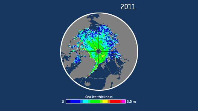
ESA’s CryoSat satellite has found that the Arctic has one of the lowest volumes of sea ice of any November, matching record lows in 2011 and 2012. Early winter growth of ice in the Arctic has been about 10% lower than usual.
Arctic freeze slows down
30.11.2016 11:00 ESA Observing the EarthESA’s CryoSat satellite has found that the Arctic has one of the lowest volumes of sea ice of any November, matching record lows in 2011 and 2012. Early winter growth of ice in the Arctic has been about 10% lower than usual.