


![]()

zprávy
zdroje zpráv:Stahovací služba Atom pro katastrální mapu ČR dělenou po katastrálních územích - VFK
28.11.2016 1:00 Cenia - Katalog metadat ČR - INSPIRE Katastrální mapa je závazným státním mapovým dílem velkého měřítka, obsahuje body polohového bodového pole, polohopis a popis. Polohopis katastrální mapy obsahuje zobrazení hranic katastrálních území, hranic územních správních jednotek, státních hranic, hranic pozemků, obvodů budov a vodních děl evidovaných v katastru, další prvky polohopisu (mosty, tunely), hranice chráněných území a ochranných pásem, hranice rozsahu věcného břemene k části pozemku. V rámci této stahovací služby je KM poskytována rozděleně po katastrálních územích ve formátu VFK v souřadnicovém systému JTSK (EPSG:5514). K dispozici jsou pouze ta území, ve kterých je KM vedena ve formě DKM, nebo KMD.Stahovací služba Atom pro data RÚIAN ve formátu csv - adresy děleny po obcích
28.11.2016 1:00 Cenia - Katalog metadat ČR - INSPIRE Data vychází z Registru územní identifikace, adres a nemovitostí (RÚIAN), který je součástí základních registrů České republiky a obsahuje informace o územní identifikaci, adresách a nemovitostech. Data jsou poskytována v souborech formátu CSV a pro stažení jsou soubory komprimovány jako archivy Gzip. Soubory jsou generovány vždy v prvním dni každého měsíce s daty platnými k poslednímu dni měsíce předchozího. Datové soubory obsahují seznam adresních míst vybrané obce s následujícími atributy: kód adresního místa, kód obce, název obce, název městského obvodu/městské části (vyplněn pouze u územně členěných statutárních měst), název městského obvodu Prahy (vyplněn pouze u Prahy), kód části obce, název části obce, název ulice (pouze u obcí se zavedenou uliční sítí), typ stavebního objektu (s č. p./s č. ev.), číslo domovní, číslo orientační, znak čísla orientačního (vyplněn pouze, pokud je k orientačnímu číslu přidělen), PSČ, souřadnice X a souřadnice Y definičního bodu adresního místa a datum platnosti.INSPIRE stahovací služba ATOM pro téma Územní správní jednotky (AU)
28.11.2016 1:00 Cenia - Katalog metadat ČR - INSPIRE Stahovací služba pro téma Územní správní jednotky (AU) je veřejná stahovací služba pro poskytování dat z INSPIRE tématu Územní správní jednotky (AU), umožňující uživatelům opakované stahování těchto dat v souborech po obcích a online přístup k těmto datům pomocí technologie Atom. Stahovací služba poskytuje harmonizovaná data tématu Územní správní jednotky (AU) ve formátu GML 3.2.1 ve struktuře dané datovou specifikací a XML schématy ve verzi 3.0. Služba je dostupná pro celé území České Republiky. Služba splňuje technické pokyny pro INSPIRE stahovací služby verze 3.1.Stahovací služba Atom pro katastrální mapu ČR dělenou po katastrálních pracovištích - VFK
28.11.2016 1:00 Cenia - Katalog metadat ČR - INSPIRE Katastrální mapa je závazným státním mapovým dílem velkého měřítka, obsahuje body polohového bodového pole, polohopis a popis. Polohopis katastrální mapy obsahuje zobrazení hranic katastrálních území, hranic územních správních jednotek, státních hranic, hranic pozemků, obvodů budov a vodních děl evidovaných v katastru, další prvky polohopisu (mosty, tunely), hranice chráněných území a ochranných pásem, hranice rozsahu věcného břemene k části pozemku. V rámci této stahovací služby je KM poskytována rozděleně po katastrálních pracovištích ve formátu VFK v souřadnicovém systému JTSK (EPSG:5514). K dispozici jsou pouze ta území, ve kterých je KM vedena ve formě DKM, nebo KMD.Stahovací služba Atom pro katastrální mapu ČR dělenou po katastrálních územích - DGN
28.11.2016 1:00 Cenia - Katalog metadat ČR - INSPIRE Katastrální mapa je závazným státním mapovým dílem velkého měřítka, obsahuje body polohového bodového pole, polohopis a popis. Polohopis katastrální mapy obsahuje zobrazení hranic katastrálních území, hranic územních správních jednotek, státních hranic, hranic pozemků, obvodů budov a vodních děl evidovaných v katastru, další prvky polohopisu (mosty, tunely), hranice chráněných území a ochranných pásem, hranice rozsahu věcného břemene k části pozemku. V rámci této stahovací služby je KM poskytována rozděleně po katastrálních územích ve formátu DGN v souřadnicovém systému JTSK (EPSG:5514). K dispozici jsou pouze ta území, ve kterých je KM vedena ve formě DKM, nebo KMD.INSPIRE stahovací služba ATOM pro téma Budovy (BU)
28.11.2016 1:00 Cenia - Katalog metadat ČR - INSPIRE Stahovací služba pro téma Budovy (BU) je veřejná stahovací služba pro poskytování dat z INSPIRE tématu Budovy (BU), umožňující uživatelům opakované stahování těchto dat v souborech po obcích a online přístup k těmto datům pomocí technologie Atom. Stahovací služba poskytuje harmonizovaná data tématu Budovy (BU) ve formátu GML 3.2.1 ve struktuře dané datovou specifikací a XML schématy ve verzi 3.0. Služba je dostupná pro celé území České Republiky. Služba splňuje technické pokyny pro INSPIRE stahovací služby verze 3.1.Stahovací služba Atom pro data RÚIAN ve formátu csv - adresy pro stát
28.11.2016 1:00 Cenia - Katalog metadat ČR - INSPIRE Data vychází z Registru územní identifikace, adres a nemovitostí (RÚIAN), který je součástí základních registrů České republiky a obsahuje informace o územní identifikaci, adresách a nemovitostech. Data jsou poskytována v souborech formátu CSV a pro stažení je datová sada komprimována jako archiv Gzip. Soubory jsou generovány vždy v prvním dni každého měsíce s daty platnými k poslednímu dni měsíce předchozího. Datová sada obsahuje soubory adresních míst jednotlivě pro všechny obce ČR. Soubory jednotlivých obcí obsahují seznam adresních míst dané obce s následujícími atributy: kód adresního místa, kód obce, název obce, název městského obvodu/městské části (vyplněn pouze u územně členěných statutárních měst), název městského obvodu Prahy (vyplněn pouze u Prahy), kód části obce, název části obce, název ulice (pouze u obcí se zavedenou uliční sítí), typ stavebního objektu (s č. p./s č. ev.), číslo domovní, číslo orientační, znak čísla orientačního (vyplněn pouze, pokud je k orientačnímu číslu přidělen), PSČ, souřadnice X a souřadnice Y definičního bodu adresního místa a datum platnosti.ČGS – Cestovatelský úterek 29. 11. 2016 (Malajsie)
25.11.2016 19:47 Katedra geografie UP Olomouc Zveme Vás na přednášku v cyklu Cestovatelské úterkyMalajsie: Tropická téměř Evropa
která se uskuteční v úterý 29. listopadu 2016 od 18.30 do 20.00 na učebně LP 2005. Přednáší Jiří Skořepa a Vendula Kurdíková (pozvánka).
ČGS – Blok expertů ESUR 30. 11. 2016
25.11.2016 19:29 Katedra geografie UP Olomouc Zveme Vás na přednášku v rámci Bloku expertů ESURZemědělská půda a její stav v České republice
která se uskuteční ve středu 30. listopadu 2016 od 15.00 do 16.30 na učebně LP 5007 Přírodovědecké fakulty UP. Přednáší Jan Vopravil (pozvánka).
ČGS – Blok expertů MRS 28. 11. 2016
25.11.2016 19:24 Katedra geografie UP Olomouc Zveme Vás na přednášku v rámci Bloku expertů MRS"Dobré vládnutí" ve špatných podmínkách: subsaharská Afrika
která se uskuteční v pondělí 28. listopadu 2016 od 16.45 do 18.15 na učebně LP 3003 Přírodovědecké fakulty UP. Přednáší Jan Prouza (pozvánka).
Shaping the future
25.11.2016 16:21 ESA Observing the Earth
The Ministers of Space meet in December to set ESA's strategy and policies. ESA is proposing the next-generation scientific Earth observation programme at the council
Ještě jedno ohlédnutí za 25. konferencí GIS Esri v ČR
25.11.2016 14:18 GISportal.cz Společnost ARCDATA PRAHA zveřejnila na stránkách konference sborník z konference, fotogralerii i videa z prvního dne konference, včetně hodinové prezentace Jack Dangermonda či ukázka využití GIS ve Švýcarsku. Když bilancují pořadatelé, rozhodli jsme se bilancovat i ...20161126-VŘ Administrace databází 11. platová třída
25.11.2016 12:27 ČÚZK - předpisy a opatření Oznámení o vyhlášení výběrového řízení na služební místo administrace databází (11. platová třída) - informace zde.20161126-VŘ Administrace databází 11. platová třída
25.11.2016 12:27 ČÚZK - předpisy a opatření Oznámení o vyhlášení výběrového řízení na služební místo administrace databází (11. platová třída) - informace zde.20161126-VŘ Administrace databází 11. platová třída
25.11.2016 12:27 ČÚZK /Aktuality-resort/2016/20161126-VR-Administrace-databazi-11-platova-trida20161126-VŘ Administrace databází 11. platová třída
25.11.2016 12:27 ČÚZK /Aktuality-resort/20161126-VR-Administrace-databazi-11-platova-trida20161126-VŘ Administrace databází 13. platová třída
25.11.2016 12:21 ČÚZK - předpisy a opatření Oznámení o vyhlášení výběrového řízení na služební místo administrace databází (13. platová třída) - informace zde.20161126-VŘ Administrace databází 13. platová třída
25.11.2016 12:21 ČÚZK - předpisy a opatření Oznámení o vyhlášení výběrového řízení na služební místo administrace databází (13. platová třída) - informace zde.20161126-VŘ Administrace databází 13. platová třída
25.11.2016 12:21 ČÚZK /Aktuality-resort/2016/20161126-VR-Administrace-databazi-13-platova-trida20161126-VŘ Administrace databází 13. platová třída
25.11.2016 12:21 ČÚZK /Aktuality-resort/20161126-VR-Administrace-databazi-13-platova-tridaOmluvte, prosím, dočasnou nefu
25.11.2016 12:00 Ústecký kraj Omluvte, prosím, dočasnou nefunkčnost výdejního modulu. O změně stavu vás budeme informovat.Administrace databází (13. platová třída)
25.11.2016 11:37 ČÚZK - volná místa Český úřad zeměměřický a katastrální, vypisuje výběrové řízení na místo Administrace databází (13. platová třída)Administrace databází (13. platová třída)
25.11.2016 11:37 ČÚZK - předpisy a opatření Český úřad zeměměřický a katastrálnívypisuje výběrové řízení na místo
Administrace databází (13. platová třída)
Administrace databází (11. platová třída)
25.11.2016 11:07 ČÚZK - volná místa Český úřad zeměměřický a katastrální, vypisuje výběrové řízení na místo Administrace databází (11. platová třída)Administrace databází (11. platová třída)
25.11.2016 11:07 ČÚZK - předpisy a opatření Český úřad zeměměřický a katastrálnívypisuje výběrové řízení na místo
Administrace databází (11. platová třída)
Satellites confirm sinking of San Francisco tower
25.11.2016 11:00 ESA Observing the Earth
The Sentinel-1 satellites have shown that the Millennium Tower skyscraper in the centre of San Francisco is sinking by a few centimetres a year. Studying the city is helping scientists to improve the monitoring of urban ground movements, particularly for subsidence hotspots in Europe.
20161126-VŘ Analytik - programátor
25.11.2016 10:47 ČÚZK /Aktuality-resort/20161126-VR-Analytik-programator20161126-VŘ Analytik - programátor
25.11.2016 10:47 ČÚZK /Aktuality-resort/2016/20161126-VR-Analytik-programator20161126-VŘ Analytik - programátor
25.11.2016 10:47 ČÚZK - předpisy a opatření Oznámení o vyhlášení výběrového řízení na služební místo analytik - programátor zde.20161126-VŘ Analytik - programátor
25.11.2016 10:47 ČÚZK - předpisy a opatření Oznámení o vyhlášení výběrového řízení na služební místo analytik - programátor zde.Japan
25.11.2016 10:05 ESA Observing the Earth
Earth observation image of the week: a Sentinel-3 image of Japan, also featured on the Earth from Space video programme
Měli jsme ukázku mapování pro studenty Univerzity Karlovy v Botanické zahradě
25.11.2016 10:02 UpVision Měli jsme ukázku některých našich UAV a mapování z nich pro studenty Univerzity Karlovy v Botanické zahradě na Albertově v Praze. Povolení k létání v HOP bylo samozřejmostí.Několik fotek z botanické zahrady zde:
https://plus.google.com/+UpvisionCz1/posts/2JbSbdt3Dxu
Analytik - programátor (2)
25.11.2016 9:47 ČÚZK /Urady/Cesky-urad-zememericky-a-katastralni/Uredni-deska/Oznameni-a-jina-uredni-sdeleni/Volna-mista/Analytik-programator-(2)Analytik - programátor (2)
25.11.2016 9:47 ČÚZK - předpisy a opatření Český úřad zeměměřický a katastrálnívypisuje výběrové řízení na místo
Analytik - programátor
Analytik - programátor (2)
25.11.2016 9:47 ČÚZK - volná místa Český úřad zeměměřický a katastrální, vypisuje výběrové řízení na místo Analytik - programátor (2)Fast forest views
25.11.2016 9:10 ESA Observing the Earth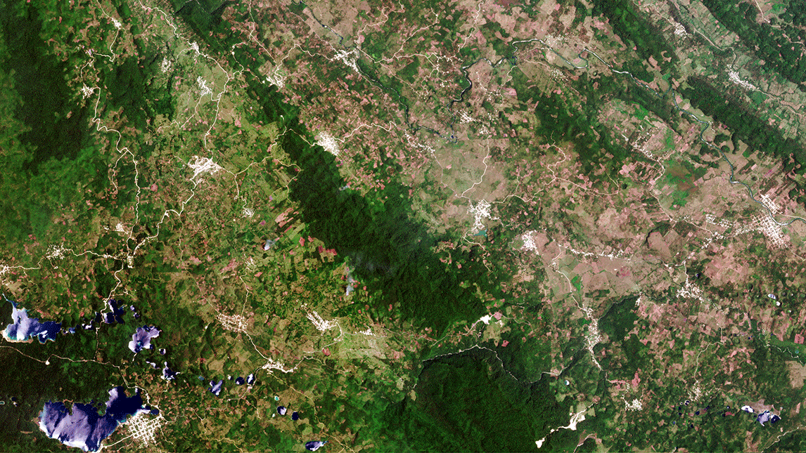
ESA’s new cloud-based Forestry Thematic Exploitation Platform allows the rapid production of highly detailed land-cover maps such as this view of forest in Mexico
odborný referent – obnova katastrálního operátu v technickém odboru Katastrálního úřadu pro Mora (1)
25.11.2016 8:33 ČÚZK - předpisy a opatření Katastrální úřad pro Moravskoslezský krajvypisuje výběrové řízení na místo odborný referent – obnova katastrálního operátu v technickém odbor
odborný referent – obnova katastrálního operátu v technickém odboru Katastrálního úřadu pro Moravskoslezský kraj
odborný referent – obnova katastrálního operátu v technickém odboru Katastrálního úřadu pro Mora (1)
25.11.2016 8:33 ČÚZK /Urady/Katastralni-urady/Katastralni-urady/Katastralni-urad-pro-Moravskoslezsky-kraj/Uredni-deska/Oznameni-a-jina-uredni-sdeleni/Volna-mista/odborny-referent-–-obnova-katastralniho-operat-(3)odborný referent – obnova katastrálního operátu v technickém odboru Katastrálního úřadu pro Mora (1)
25.11.2016 8:33 ČÚZK - volná místa Katastrální úřad pro Moravskoslezský kraj, vypisuje výběrové řízení na místo odborný referent – obnova katastrálního operátu v technickém odboru Katastrálního úřadu pro Mora (1)Oznámení o vyhlášení výběrového řízení na služební místo rada/odborný rada odboru ekonomickém, oddělení správy pohledávek
25.11.2016 0:00 Státní pozemkový úřad Ústřední ředitelka Státního pozemkového úřadu, jako služební orgán příslušný podle § 10 odst. 1 písm. f) zákona č. 234/2014 Sb., o státní službě (dále jen „zákon“), vyhlašuje výběrové řízení.Vyhlášení platnosti OKO v části k.ú. Rychnov u Verneřic
24.11.2016 15:11 ČÚZK - předpisy a opatření Vážení klienti,dne 24.11.2016 byla vyhlášena platnost obnoveného katastrálního operátu v části katastrálního území Rychnov u Verneřic. Více podrobností naleznete zde.
Vyhlášení platnosti OKO v části k.ú. Rychnov u Verneřic
24.11.2016 15:11 ČÚZK /Urady/Katastralni-urady/Katastralni-urady/Katastralni-urad-pro-Ustecky-kraj/Katastralni-pracoviste/KP-Decin/O-uradu/Aktuality/Vyhlaseni-platnosti-OKO-v-casti-l-u-Rychnov-u-VernEarth from Space
24.11.2016 14:30 ESA Observing the Earth
Join us Friday, 25 November, at 10:00 CET for the ‘Earth from Space’ video programme. This week features a Sentinel-3 image of Japan
Přerušení provozu DP a WSDP - 2.12.2016
24.11.2016 13:20 Dálkový přístup k údajům KN ČR Oznamujeme přerušení provozu Dálkového přístupu i Webových služeb dálkového přístupu. Provoz bude přerušen v pátek 2.12.2016 od 14:30 hodin. Obnovení provozu předpokládáme cca ve 24:00 hodin. Za komplikace tímto způsobené se omlouváme a děkujeme za pochopení.Přerušení provozu DP a WSDP - 2.12.2016
24.11.2016 13:20 ČÚZK /Aplikace-DP-do-KN/Aplikace-DP-do-KN/Archiv-DP/150928Přerušení provozu DP a WSDP - 2.12.2016
24.11.2016 13:20 ČÚZK - předpisy a opatřeníOznamujeme přerušení provozu Dálkového přístupu i Webových služeb dálkového přístupu. Provoz bude přerušen v pátek 2.12.2016 od 14:30 hodin. Obnovení provozu předpokládáme cca ve 24:00 hodin. Za komplikace tímto způsobené se omlouváme a děkujeme za pochopení.
5. setkání ve Villa Hrdlička
24.11.2016 13:01 HrdličkaZa doprovodu hudby zobcových fléten dětí ze ZUŠ Česká Lípa hosty při příchodu vítali paní starostka Romana Žatecká a majitel společnosti HRDLIČKA pan Martin Hrdlička. Hlavním bodem programu bylo koncertní vystoupení harfistky Jany Bouškové a klavíristy Lukáše Klánského. Přítomní hosté tak měli mnohdy poprvé možnost naživo slyšet tóny harfy, například při interpretaci skladby Vltava od... View Article
The post 5. setkání ve Villa Hrdlička appeared first on HRDLIČKA spol. s r.o. - komplexní služby v oblasti geodézie.
5. setkání ve Ville Hrdlička
24.11.2016 13:01 HrdličkaZa doprovodu hudby zobcových fléten dětí ze ZUŠ Česká Lípa hosty při příchodu vítali paní starostka Romana Žatecká a majitel společnosti HRDLIČKA pan Martin Hrdlička. Hlavním bodem programu bylo koncertní vystoupení harfistky Jany Bouškové a klavíristy Lukáše Klánského. Přítomní hosté tak měli mnohdy poprvé možnost naživo slyšet tóny harfy, například při interpretaci skladby Vltava od... View Article
The post 5. setkání ve Ville Hrdlička appeared first on HRDLIČKA spol. s r.o. - komplexní služby v oblasti geodézie.
Nová verze 21.0 programu GEUS
24.11.2016 12:00 GEUSwareNová verze 21.0 programu GEUS obsahuje již funkci pro odesílání geometrického plánu na KP pomocí služby WSGP 2. část.
Další zajímavou funkcí je možnost stažení a importu katastrálních map ve formátu DGN, které jsou aktualizovány s denní frekvencí z ISKN. Tato cesta ke kresbě katastrální mapy je podstatně rychlejší a pohodlnější, než import z VFK nebo XML. Funkce využívá poměrně nedávného zveřejnění těchto map na http://services.cuzk.cz/.
Poslední verze programu je k dispozici na stránce Stáhnout
Uživatelé se zaplacenou licenční podporou pro rok 2016 mohou novou verzi rovnou stáhnout, nainstalovat a spustit - program si sám stáhne licenci ze serveru - potom lze novou verzi ihned používat. Uživatelé se zakoupenou verzí 20.0 bez licenční podpory mohou do 31.1.2017 zakoupit upgrade na verzi 21.0 za zvýhodněnou cenu 4.800,- Kč bez DPH. Po 31.1.2017 bude již platit standardní cena upgrade 5.800,- Kč bez DPH. Jedná se o základní cenu z které se počítají standardní množstevní slevy 20% až 50%.
Funkce "Odeslání GP - WSGP" je uvolňována v "nulté" verzi, tedy se předpokládají rychlé úpravy a optimalizace na základě zkušeností a požadavků většího počtu uživatelů.
Podrobný seznam změn a oprav nové verze naleznete na stránce Změny
Na železnicích jako ryba ve vodě
24.11.2016 11:32 HrdličkaV letošním roce jsme dokončili práce na těchto železničních stavbách: BUVOL – Rekonstrukce trati České Budějovice – Volary Celkové investiční náklady 1 289 666 551 Kč Termín 3/2014 – 10/2016 Hlavní zhotovitel AŽD Praha s.r.o. – DTI Délka trati 93 km Počet rekonstruovaných stanic (zastávek) 13 Počet obnovovaných mostů 5 Realizace Pracoviště Jižní Čechy Kromě svého... View Article
The post Na železnicích jako ryba ve vodě appeared first on HRDLIČKA spol. s r.o. - komplexní služby v oblasti geodézie.
Systém Pasportizace Ústeckého kraje získal ocenění
24.11.2016 11:21 T-MAPY Úspěšný projekt Pasportizační systém nemovitého majetku Ústeckého kraje získal ocenění v soutěži Egovernment The Best 2016 - Deloitte v kategorii projekty krajů.20161124-ocenění magazínu Egovernment
24.11.2016 11:14 ČÚZK - předpisy a opatření Magazín Egovernment udělil ČÚZK speciální ocenění za podíl na evropském projektu ELF. O projektu více zde.20161124-ocenění magazínu Egovernment
24.11.2016 11:14 ČÚZK - předpisy a opatření Magazín Egovernment udělil ČÚZK speciální ocenění za podíl na evropském projektu ELF. O projektu více zde.Kosmonaut Paolo Nespoli má novou posádku
24.11.2016 8:27 Český Kosmický PortálPartneři v projektu Mezinárodní kosmické stanice oznámili změny v posádkách týkající se misí v roce 2017. Pro kosmonauta ESA Paola Nespoliho to znamená, že byl jmenovaný k letu s „novou“ posádkou.
Kosmonaut Paolo Nespoli má novou posádku
24.11.2016 8:27 Český Kosmický PortálPartneři v projektu Mezinárodní kosmické stanice oznámili změny v posádkách týkající se misí v roce 2017. Pro kosmonauta ESA Paola Nespoliho to znamená, že byl jmenovaný k letu s „novou“ posádkou.
ERASMUS info day 24. 11. 2016
24.11.2016 6:58 Katedra geografie UP Olomouc Přemýšlíte o výjezdu s programem Erasmus+ na zahraniční studijní nebo pracovní stáž? Rádi byste věděli, jak si podat přihlášku, jak probíhá výběrové řízení a vše, co je potřebné vědět před a po výjezdu na zahraniční univerzitu nebo instituci? Pak přijďte na celofakultní Erasmus Info Day, který se koná ve čtvrtek 24. listopadu 2016 od 16.00 do 18.00 v aule Přírodovědecké fakulty (učebna 2.001).Prohlížecí služba WMS - SM 5 vektor
24.11.2016 1:00 Cenia - Katalog metadat ČR - INSPIRE Prohlížecí služba WMS-SM5V je poskytována jako veřejná prohlížecí služba nad vektorovými daty inovovaného produktu Státní mapy v měřítku 1:5 000. Na rozdíl od služby WMS-SM5, která poskytuje (z území celé ČR) pouze černobílý rastrový obraz katastrální složky původní SM 5 a není již nadále aktualizována, poskytuje tato nová služba barevná vektorová data nové formy SM 5, navíc s možností vypínání vrstev a dotazů na atributy. Vzhledem k tomu, že data jsou odvozována z digitální katastrální mapy, jsou značně aktuálnější, než data služby WMS-SM5, pokrývají však prozatím pouze 64 166,35 km2, což je asi 81,36 % rozlohy ČR. Služba splňuje Technické pokyny pro INSPIRE prohlížecí služby v. 3.11 a zároveň splňuje standard OGC WMS 1.1.1. a 1.3.0.Prohlížecí služba WMTS - SM 5 vektor
24.11.2016 1:00 Cenia - Katalog metadat ČR - INSPIRE Prohlížecí služba WMTS-SM5V je poskytována jako veřejná prohlížecí služba nad vektorovými daty inovovaného produktu Státní mapy 1:5 000. Na rozdíl od služby WMS-SM5V, poskytuje tato služba barevná vektorová data nové formy SM 5 formou rastrových dlaždic, což významně zrychluje odezvy služby. Není však k dispozici možnost vypínání vrstev a dotazů na atributy prvků. Vzhledem k tomu, že data jsou odvozována z digitální katastrální mapy, pokrývají prozatím pouze 64 166,35 km2, což je asi 81,36 % rozlohy ČR. Služba splňuje Technické pokyny pro INSPIRE prohlížecí služby v. 3.11 a zároveň splňuje standard OGC WMS 1.1.1. a 1.3.0.Oznámení o vyhlášení výběrového řízení na služební místo vedoucí Pobočky Karlovy Vary
24.11.2016 0:00 Státní pozemkový úřad Ústřední ředitelka Státního pozemkového úřadu, jako služební orgán příslušný podle § 10 odst. 1 písm. f) zákona č. 234/2014 Sb., o státní službě (dále jen „zákon“), vyhlašuje výběrové řízení.ERASMUS info day
23.11.2016 20:34 Katedra geografie UP Olomouc Přemýšlíte o výjezdu s programem Erasmus+ na zahraniční studijní nebo pracovní stáž? Rádi byste věděli, jak si podat přihlášku, jak probíhá výběrové řízení a vše, co je potřebné vědět před a po výjezdu na zahraniční univerzitu nebo instituci? Pak přijďte na celofakultní Erasmus Info Day, který se koná ve čtvrtek 24. listopadu 2016 od 16.00 do 18.00 v aule Přírodovědecké fakulty (učebna 2.001).Zeměměřič 11+12/2016 právě vyel
23.11.2016 17:11 Zeměměřič V digitální podobě máte časopis ji nyní. Na papírovou podobu si musíte jetě nějaký den počkat. Ale v listopadu to bude jistojistě - vdy se jedná o prosincové vánoční číslo.Mind the gap! BIM level 3 is a quantum leap for industry, warns Mark Bew
23.11.2016 17:04 Bentley SystemsPress Coverage
PCSG
Read the articleMetody pro projektový management
23.11.2016 14:03 Česká kosmická kancelář
Při práci na projektech je možné využít celou řadu nástrojů a metod, které řízení projektů významným způsobem zjednodušují a zpřehledňují. Mnoho z těchto metod je i součástí ECSS standardů, které jsou využívány v kosmonautice. Tento článek přináší přehled těch nejvíce využívaných.
Odvolání termínu přerušení provozu DP a WSDP 25.11.2016.
23.11.2016 13:48 ČÚZK - předpisy a opatřeníOznamujeme, že předběžně oznámené přerušení provozu DP a WSDP neproběhne v dříve oznámeném termínu 25.11.2016.
Nový termín přerušení provozu bude oznámen nejpozději 25.11.2016.
Za komplikace tímto způsobené se omlouváme a děkujeme za pochopení.
Odvolání termínu přerušení provozu DP a WSDP 25.11.2016.
23.11.2016 13:48 Dálkový přístup k údajům KN ČR Oznamujeme, že předběžně oznámené přerušení provozu DP a WSDP neproběhne v dříve oznámeném termínu 25.11.2016.Nový termín přerušení provozu bude oznámen nejpozději 25.11.2016.
Za komplikace tímto způsobené se omlouváme a děkujeme za pochopení.
Odvolání termínu přerušení provozu DP a WSDP 25.11.2016.
23.11.2016 13:48 ČÚZK /Aplikace-DP-do-KN/Aplikace-DP-do-KN/Archiv-DP/150844Start of service for Europe’s SpaceDataHighway
23.11.2016 13:41 ESA Observing the Earth
The European Data Relay System began servicing Europe’s Earth observing Copernicus programme yesterday, transferring observations in quasi-real time using cutting-edge laser technology.
Early warning from space of homes on the slide
23.11.2016 13:22 ESA Observing the Earth
It was a literal property crash: multiple homes in the Cármenes del Mar resort on the south coast of Spain were engulfed in a landslide, leaving families homeless. But satellite archives offer early warning of such events – and now more accessible than ever before thanks to a new cloud computing platform.
Přednáška: Hospodaření s dešťovou vodou 24. 11. 2016
23.11.2016 12:42 Katedra geografie UP Olomouc Zveme Vás na přednášku na témaHospodaření s dešťovou vodou: Zásadní podmínka pro adaptaci měst na změnu klimatu
která se uskuteční ve čtvrtek 24. listopadu 2016 od 10.30 v učebně LP 5006. Přednáší ing. Ondřej Vítek (pozvánka).
Přednáška: Metodické vedení obcí v oblasti strategického plánování 24. 11. 2016
23.11.2016 12:38 Katedra geografie UP Olomouc Zveme Vás na přednášku absolventa olomoucké geografie na témaMetodické vedení obcí v oblasti strategického plánování
která se uskuteční ve čtvrtek 24. listopadu 2016 od 15.30 v učebně LP 2006. Přednáší Stanislav Jaša z Krajského úřadu Zlínského kraje (pozvánka).
Galileo teamwork
23.11.2016 12:00 ESA Navigation
Operations image of the week: Mission control shepherds four Galileo satellites in orbit
V mapové aplikaci byla aktual
23.11.2016 12:00 Jihočeský kraj V mapové aplikaci byla aktualizována územně plánovací dokumentace obcí Vidov, Vitín, Záboří, Zahájí, Závraty, Zliv, Zvíkov a Žabovřesky. Nově pak byla přidána územně plánovací dokumentace obce Osek (Strakonice).V mapové aplikaci Územně pláno
23.11.2016 12:00 Jihočeský kraj V mapové aplikaci Územně plánovací dokumentace obcí byla aktualizována územně plánovací dokumentace obcí Vidov, Vitín, Záboří, Zahájí, Závraty, Zliv, Zvíkov a Žabovřesky. Nově pak byla přidána územně plánovací dokumentace obce Osek (Strakonice).Opendatová aplikace roku 2016 Hlídač smluv, identifikuje zneužití moci v úřadech
23.11.2016 10:59 Otevřená data Včera večer byly slavnostně vyhlášeny výsledky 4. ročníku soutěže Společně otevíráme data, ve kterém se utkalo 30 aplikací představujících pozoruhodný mix komerčních, neziskových a studentských projektů. Mezi oceněnými projekty jsou aplikace odkrývající hospodaření státních institucí, správu veřejného majetku či zpřístupňující město bez bariér.Opendatová aplikace roku 2016 Hlídač smluv, identifikuje zneužití moci v úřadech
23.11.2016 10:59 Otevřená data Včera večer byly slavnostně vyhlášeny výsledky 4. ročníku soutěže Společně otevíráme data, ve kterém se utkalo 30 aplikací představujících pozoruhodný mix komerčních, neziskových a studentských projektů. Mezi oceněnými projekty jsou aplikace odkrývající hospodaření státních institucí, správu veřejného majetku či zpřístupňující město bez bariér.Podzimní novinky ze světa GIS
23.11.2016 10:00 ARCDATANechte se inspirovat ukázkami práce uživatelů, zajímavými příběhy i nejrůznějšími novinkami. Poslední letošní vydaní časopisů Esri nabízí například články o objevech Alexandra von Humboldta, o neuvěřitelném příběhu rakouského geografa, který pomáhá v Amazonii, nebo o novinkách v ArcGIS ve verzi 10.5.
I tentokrát jsme pro vás připravili přehled článků z časopisů ArcNews a ArcUser, který naleznete na samostatné stránce.

GSA extends scope of ISO 9001 certification
23.11.2016 9:52 European GNSS Agency
The scope of the GSA’s ISO 9001 certification has been extended to include the management of the Galileo exploitation phase and the operation of the Galileo Security Monitoring Centre (GSMC). The announcement follows extensive internal and external audits of the GSMC in France and GSA Headquarters in Prague.
ISO 9001 is an internationally-recognised standard certifying an organisation’s Quality Management System (QMS). The GSA’s QMS has been ISO 9001 certified since December 2014, with the original certification covering activities in preparation for the Galileo exploitation phase and GSMC activities. The extended certification now covers all Agency activities related to the development, maintenance and improvement of European GNSS user-oriented services and related infrastructure, including: managing the EGNOS and Galileo exploitation phases, operating the GSMC, supporting security accreditation and promoting innovation in GNSS applications and services with the support of an enabling administrative platform (i.e., legal, procurement, human resources, ICT, communications, etc.).
“As we move closer to the declaration of Galileo Initial Services, this extended certification is an important step as it demonstrates the GSA’s commitment to quality processes and allows us to deliver more effective and efficient services that better respond to user needs,” says GSA Executive Director Carlo des Dorides.
The current certification is valid through December 2017. The GSA is already preparing to renew the certification.
About ISO 9001
The International Standards Organisation (ISO) is a worldwide federation of national standards bodies (ISO member bodies). The work of preparing International Standards is carried out through ISO technical committees, in liaison with international organisations, governmental and non-governmental bodies.
ISO 9001 specifies the requirements for a Quality Management System (QMS) that may be used by organisations for internal application, certification or contractual purposes. The process approach is shown in the conceptual model from the ISO 9001 Standard, recognising that customers play a significant role in defining requirements as inputs, and monitoring of customer satisfaction is necessary to evaluate and validate whether customer requirements have been met.
Media note: This feature can be republished without charge provided the European GNSS Agency (GSA) is acknowledged as the source at the top or the bottom of the story. You must request permission before you use any of the photographs on the site. If you republish, we would be grateful if you could link back to the GSA website (http://www.gsa.europa.eu).
Kudy chodí zvířata
23.11.2016 6:30 GISportal.cz Kudy chodí zvířata (Where the Animals Go) není o nočním životě některých příslušníků lidstva, ale zcela prozaicky o tom, kudy a kam chodí, plave či létá fauna. Geograf James Cheshire a designér Oliver Uberti vytvořili společně již druhou ...Oznámená důlní díla
23.11.2016 1:00 Cenia - Katalog metadat ČR - INSPIRE Databáze obsahuje údaje o oznámených projevech starých důlních děl. Starým důlním dílem se podle zákona rozumí důlní dílo v podzemí, které je opuštěno a jehož původní provozovatel ani jeho právní nástupce neexistuje nebo není znám. Starým důlním dílem je také opuštěný lom po těžbě vyhrazených nerostů, jehož původní provozovatel ani jeho právní nástupce neexistuje nebo není znám.Siemens drives forward digital transformation
22.11.2016 20:21 Bentley SystemsPress Coverage
Siemens
Read the articleKdo se odhodlá vyrazit v roce 2017 studovat na semestr do zahraničí?
22.11.2016 18:24 Blogující geomatici - FAV ZČU Pro zájemce vyhlásila Fakulta aplikovaných věd Erasmus+ mobility pro rok 2017.Nabídka prodeje movitého majetku
22.11.2016 13:38 ČÚZK - předpisy a opatřeníZeměměřický a katastrální inspektorát v Pardubicích nabízí nepotřebný majetek k odkupu. Jedná se o
Nabídka prodeje movitého majetku
Nabídka prodeje movitého majetku
22.11.2016 13:38 ČÚZK /Urady/Zememericke-a-katastralni-inspektoraty/Zememericke-a-katastralni-inspektoraty/Zememericky-a-katastralni-inspektorat-v-Pardubicic/Nabidky-majetku/Nabidka-prodeje-moviteho-majetkuCSmap je certifikovaným profesionálem FME Desktop
22.11.2016 12:45 CSmap CSmap s.r.o. má ve svém týmu certifikovaného profesionála produktu FME od společnosti Safe Software. Certifikace zajišťuje, že při konzultaci a školení programu FME se Vám bude věnovat prověřený odborník.Call for a doctoral study position UrbanHist
22.11.2016 10:09 GISportal.cz Máte zájem o špičkovou PhD pozici v rámci evropského projektu? Tým prof. Hofierky ze Slovenska hledá šikovného kolegu, info viz níže. The European Joint Doctorate Programme urbanHist | 20th Century European Urbanism announces 15 PhD positions ...Připomeňte si konferenci
22.11.2016 10:05 ARCDATAKonference GIS Esri nabídla bohatý program. Podívejte se znovu na vystoupení hlavních řečníků nebo si připomeňte některou z prezentací.
Na stránkách konference naleznete například:
- záznamy některých přednášek,
- prezentace z přednášek,
- fotografie posterů,
- výsledky posterové a družicové soutěže,
- sborník konference,
- konferenční brožury a další materiály.

Všechny materiály a zdroje naleznete také přehledně na stránce Ke stažení.
Připomeňte si konferenci
22.11.2016 10:05 ARCDATAKonference GIS Esri nabídla bohatý program. Podívejte se znovu na vystoupení hlavních řečníků nebo si připomeňte některou z prezentací.
Na stránkách konference naleznete například:
- záznamy některých přednášek,
- prezentace z přednášek,
- fotografie posterů,
- výsledky posterové a družicové soutěže,
- sborník konference,
- konferenční brožury a další materiály.
Všechny materiály a zdroje naleznete také přehledně na stránce Ke stažení.
Začíná mimovegetační období a tak jsme mapovali hřbitov ve Frenštátě
22.11.2016 10:01 UpVision Pomalu začíná mimovegetační období (období pasportizací) a tak jsme mapovali hřbitov u Frenštátu pod Radhoštěm v obrazovém rozlišení 1 cm/px pro pasportizaci.Více zde:
https://plus.google.com/+UpvisionCz1/posts/eMh6i2ViYd7
odborný referent v oddělení aktualizace KN č. 2
22.11.2016 9:45 ČÚZK - volná místa Katastrální úřad pro Jihomoravský kraj, Katastrální pracoviště Znojmo vypisuje výběrové řízení na místo odborný referent v oddělení aktualizace KN č. 2odborný referent v oddělení aktualizace KN č. 2
22.11.2016 9:45 ČÚZK /Urady/Katastralni-urady/Katastralni-urady/Katastralni-urad-pro-Jihomoravsky-kraj/Uredni-deska/Oznameni-a-jina-uredni-sdeleni/Volna-mista/odborny-referent-v-oddeleni-aktualizace-KN-c-2-(1)odborný referent v oddělení aktualizace KN č. 2
22.11.2016 9:45 ČÚZK - předpisy a opatření Katastrální úřad pro Jihomoravský kraj Katastrální pracoviště Znojmovypisuje výběrové řízení na místo
odborný referent v oddělení aktualizace KN č. 2
Start nového navigačního kvintetu Galileo
22.11.2016 8:38 Český Kosmický PortálKosmická raketa Ariane 5 vynesla do vesmíru další čtyři satelity systému Galileo. Tím značně urychlila nasazení nového družicového navigačního systému.
Start nového navigačního kvintetu Galileo
22.11.2016 8:38 Český Kosmický PortálKosmická raketa Ariane 5 vynesla do vesmíru další čtyři satelity systému Galileo. Tím značně urychlila nasazení nového družicového navigačního systému.
Právník - referent oddělení právních vztahů
22.11.2016 8:05 ČÚZK - volná místa Katastrální úřad pro Plzeňský kraj, Katastrální pracoviště Rokycany vypisuje výběrové řízení na místo Právník - referent oddělení právních vztahůPRÁVNÍK - REFERENT ODDĚLENÍ PRÁVNÍCH VZTAHŮ
22.11.2016 8:05 ČÚZK - volná místa Katastrální úřad pro Plzeňský kraj, Katastrální pracoviště Rokycany vypisuje výběrové řízení na místo PRÁVNÍK - REFERENT ODDĚLENÍ PRÁVNÍCH VZTAHŮPrávník - referent oddělení právních vztahů
22.11.2016 8:05 ČÚZK - předpisy a opatření Katastrální úřad pro Plzeňský kraj Katastrální pracoviště Rokycanyhledá zástup za rodičovskou dovolenou na místo
Právník - referent oddělení právních vztahů
PRÁVNÍK - REFERENT ODDĚLENÍ PRÁVNÍCH VZTAHŮ
22.11.2016 8:05 ČÚZK - předpisy a opatření Katastrální úřad pro Plzeňský kraj Katastrální pracoviště Rokycanyhledá zástup za rodičovskou dovolenou na místo
PRÁVNÍK - REFERENT ODDĚLENÍ PRÁVNÍCH VZTAHŮ
Čtyři druice Galileo najednou
22.11.2016 7:07 Zeměměřič vynesla v listopadu 2016 jedna nosná raketa Ariane 5 v rámci osmého startu budování systému Galileo...Seminář BPEJ a pozemkové úpravy
22.11.2016 5:11 Zeměměřič pořádá Nemoforum ve spolupráci s ČÚZK a SPÚ ve čtvrtek 1. prosince 2016...North Wales Police Entrusts Hexagon Safety & Infrastructure and Frequentis with Joint Communications Centre Systems Upgrade
22.11.2016 4:00 Hexagon Safety & InfrastructureNorth Wales Police, a customer of Hexagon Safety & Infrastructure and Frequentis for more than a decade, has contracted with Hexagon to upgrade the existing Frequentis 3020 Integrated Communication Control System (ICCS) to the Frequentis 3020 LifeX software platform and provide associated integration to Hexagon’s Intergraph Computer-Aided Dispatch (I/CAD) incident management and dispatch system.
The upgrade provides North Wales Police with a single platform for both emergency and non-emergency forms of contact centre and control room communications including radio, telephony, email and web chat. The solution enables configurable skills-based routing of communications, provides more information on both people and properties at the point of contact through integration with other police systems and delivers automated management information reporting.
The integrated solution facilitates infrastructure consolidation through the use of a single workstation per operator position and commercial-off-the-shelf (COTS) hardware and virtualisation in the data centre. The 3020 LifeX software platform will also support the transition to the Emergency Services Network (ESN) for North Wales Police in the coming years.
Paul Shea, North Wales Police control room manager, said, “The commitment from Hexagon and Frequentis to work with us to not only enhance our communications with the public through all media channels, but also to support us to be ready for the transition to ESN is just what we need to allow us to concentrate on policing. We have worked with Hexagon and Frequentis for a long time and understand their knowledge and experience in control rooms and critical communications. This, coupled with the 3020 LifeX solution, were the reasons why we decided to implement the new ICCS and contact centre upgrade with them.”
Maximilian Weber, senior vice president EMEA at Hexagon Safety & Infrastructure, commented, “Together with Frequentis we are proud to be delivering an upgrade for North Wales Police that will truly help them with public contact and officer dispatching in the future. Not only will it bring efficiencies within the police control room but also will give the public of North Wales a better service.”
Robert Nitsch, director public safety at Frequentis, explained, “We are honoured to be entrusted by North Wales Police to install our first multimedia contact centre in the UK as well as a solution capable of transition to ESN. By using 3020 LifeX and Hexagon’s I/CAD properly integrated, we are combining our understanding of the market needs with experiences gathered in existing contact centre solutions for the benefit of North Wales Police so they can increase efficiencies to meet their targets.”
The global leader in public safety and security solutions, Hexagon Safety & Infrastructure helps protect 1 in 12 people worldwide. By improving the quality, accuracy and availability of critical information, Hexagon’s integrated solutions increase public safety and security performance and productivity, while reducing the total cost of ownership for mission-critical IT investments.
North Wales Police Entrusts Hexagon Safety & Infrastructure and Frequentis with Joint Communications Centre Systems Upgrade
22.11.2016 4:00 Hexagon Safety & Infrastructure Integrated solution provides next generation, unified communications, contact management, incident management and dispatchNorth Wales Police Entrusts Hexagon Safety & Infrastructure and Frequentis with Joint Communications Centre Systems Upgrade
22.11.2016 4:00 Hexagon Safety & Infrastructure Integrated solution provides next generation, unified communications, contact management, incident management and dispatchNorth Wales Police Entrusts Hexagon Safety & Infrastructure and Frequentis with Joint Communications Centre Systems Upgrade
22.11.2016 4:00 Hexagon Safety & InfrastructureNorth Wales Police, a customer of Hexagon Safety & Infrastructure and Frequentis for more than a decade, has contracted with Hexagon to upgrade the existing Frequentis 3020 Integrated Communication Control System (ICCS) to the Frequentis 3020 LifeX software platform and provide associated integration to Hexagon’s Intergraph Computer-Aided Dispatch (I/CAD) incident management and dispatch system.
The upgrade provides North Wales Police with a single platform for both emergency and non-emergency forms of contact centre and control room communications including radio, telephony, email and web chat. The solution enables configurable skills-based routing of communications, provides more information on both people and properties at the point of contact through integration with other police systems and delivers automated management information reporting.
The integrated solution facilitates infrastructure consolidation through the use of a single workstation per operator position and commercial-off-the-shelf (COTS) hardware and virtualisation in the data centre. The 3020 LifeX software platform will also support the transition to the Emergency Services Network (ESN) for North Wales Police in the coming years.
Paul Shea, North Wales Police control room manager, said, “The commitment from Hexagon and Frequentis to work with us to not only enhance our communications with the public through all media channels, but also to support us to be ready for the transition to ESN is just what we need to allow us to concentrate on policing. We have worked with Hexagon and Frequentis for a long time and understand their knowledge and experience in control rooms and critical communications. This, coupled with the 3020 LifeX solution, were the reasons why we decided to implement the new ICCS and contact centre upgrade with them.”
Maximilian Weber, senior vice president EMEA at Hexagon Safety & Infrastructure, commented, “Together with Frequentis we are proud to be delivering an upgrade for North Wales Police that will truly help them with public contact and officer dispatching in the future. Not only will it bring efficiencies within the police control room but also will give the public of North Wales a better service.”
Robert Nitsch, director public safety at Frequentis, explained, “We are honoured to be entrusted by North Wales Police to install our first multimedia contact centre in the UK as well as a solution capable of transition to ESN. By using 3020 LifeX and Hexagon’s I/CAD properly integrated, we are combining our understanding of the market needs with experiences gathered in existing contact centre solutions for the benefit of North Wales Police so they can increase efficiencies to meet their targets.”
The global leader in public safety and security solutions, Hexagon Safety & Infrastructure helps protect 1 in 12 people worldwide. By improving the quality, accuracy and availability of critical information, Hexagon’s integrated solutions increase public safety and security performance and productivity, while reducing the total cost of ownership for mission-critical IT investments.
North Wales Police Entrusts Hexagon Safety & Infrastructure and Frequentis with Joint Communications Centre Systems Upgrade
22.11.2016 4:00 Hexagon Safety & InfrastructureNorth Wales Police, a customer of Hexagon Safety & Infrastructure and Frequentis for more than a decade, has contracted with Hexagon to upgrade the existing Frequentis 3020 Integrated Communication Control System (ICCS) to the Frequentis 3020 LifeX software platform and provide associated integration to Hexagon’s Intergraph Computer-Aided Dispatch (I/CAD) incident management and dispatch system.
The upgrade provides North Wales Police with a single platform for both emergency and non-emergency forms of contact centre and control room communications including radio, telephony, email and web chat. The solution enables configurable skills-based routing of communications, provides more information on both people and properties at the point of contact through integration with other police systems and delivers automated management information reporting.
The integrated solution facilitates infrastructure consolidation through the use of a single workstation per operator position and commercial-off-the-shelf (COTS) hardware and virtualisation in the data centre. The 3020 LifeX software platform will also support the transition to the Emergency Services Network (ESN) for North Wales Police in the coming years.
Paul Shea, North Wales Police control room manager, said, “The commitment from Hexagon and Frequentis to work with us to not only enhance our communications with the public through all media channels, but also to support us to be ready for the transition to ESN is just what we need to allow us to concentrate on policing. We have worked with Hexagon and Frequentis for a long time and understand their knowledge and experience in control rooms and critical communications. This, coupled with the 3020 LifeX solution, were the reasons why we decided to implement the new ICCS and contact centre upgrade with them.”
Maximilian Weber, senior vice president EMEA at Hexagon Safety & Infrastructure, commented, “Together with Frequentis we are proud to be delivering an upgrade for North Wales Police that will truly help them with public contact and officer dispatching in the future. Not only will it bring efficiencies within the police control room but also will give the public of North Wales a better service.”
Robert Nitsch, director public safety at Frequentis, explained, “We are honoured to be entrusted by North Wales Police to install our first multimedia contact centre in the UK as well as a solution capable of transition to ESN. By using 3020 LifeX and Hexagon’s I/CAD properly integrated, we are combining our understanding of the market needs with experiences gathered in existing contact centre solutions for the benefit of North Wales Police so they can increase efficiencies to meet their targets.”
The global leader in public safety and security solutions, Hexagon Safety & Infrastructure helps protect 1 in 12 people worldwide. By improving the quality, accuracy and availability of critical information, Hexagon’s integrated solutions increase public safety and security performance and productivity, while reducing the total cost of ownership for mission-critical IT investments.