


![]()

zprávy
zdroje zpráv:EGNOS key for emergency and medical operations in EU COVID-19 response
29.5.2020 11:22 European GNSS Agency
The European Space Programmes are playing a key role in managing the COVID-19 pandemic and in particular in supporting emergency and medical operations in all weather, anytime, when they are most needed. We have talked to air ambulance and emergency operators using EGNOS about their experience and how EGNOS is helping them to take care of EU citizens, operate more effectively in these difficult times and save lives.
During this difficult period, the perception of our world has changed and we recognise the health sector and care givers as our new heroes. When patients from remote areas need to be taken to a hospital at night, in difficult weather situations and life is at stake, EGNOS makes the operation safe. Michael Diefenbach, Managing Director of German air ambulance operator Jetcall noted “We do see an increase in complex mission requests that are extremely challenging, both medically as well as from the operational and aviation perspective,” he said.
Patients with confirmed COVID-19 infection need to be transported in an operation that is safe for patients and crew.

EGNOS to save lives during critical missions
The accessibility and efficiency gains offered by EGNOS make it possible to land in adverse weather conditions and limited visibility, which is a major advantage. The gains on mission time might well make the difference between life and death of a critically ill patient in regions with limited medical services available.
Watch this: EGNOS for Aviation - Making Europe's airports more accessible
Jetcall is being funded by the GSA to upgrade two air ambulance aircraft with EGNOS capabilities in order to better serve their clients. EGNOS enables instrument approach procedures best suited for these operations, such as low-level routes, which means being able to fly at low altitude.
Previously, operators had to fly under visual flight rules, and therefore faced restrictions in difficult weather conditions or at night. This type of operation can be implemented at helipads in hospitals without the ground infrastructure costs required in conventional operations. In this way, EGNOS provides a cost efficient and safe solution to transfer patients and medical teams to those hospitals with increased reliability and availability, which is essential to save lives.
“Any tool that allows us to perform faster approaches, to use more remote airfields located closer to the patient, or utilise this last available airport that still accepts us for re-fuel or overnight stops might become mission critical. It makes a huge difference, not only to our ability to execute a mission and stay in business, but most importantly to the patients and their families, who face the very real and present danger of losing a loved one,” Diefenbach said.
“Our clients are constantly looking for two things in their service providers: outstanding quality in the medical services performed on board, and maximum reliability without compromising on flexibility. Having systems like EGNOS services available is definitely an added value as regards mission capability and flexibility and this is highly appreciated by our customers,” he added.
Read this: Maintaining EGNSS operations and security in challenging times: the GSA response
Like Diefenbach, Ivo Airaudi, crew training post holder at the Italian emergency operator Airgreen is also seeing increased challenges in helicopter rescue missions during the COVID-Crisis.
However, helicopters have been called also for transporting medical doctors and equipment on remote sites. In such situations EGNOS is making the operation possible. “Our helicopters are able to work with EGNOS and to profit from its high accuracy and integrity, which is much better than with standard GPS,” he said. “For example, in one of our rescue bases located on Cuneo Airport if we have bad weather conditions using standard procedures, we may not be able to land at an airport. But using LPV (localizer performance with vertical guidance) we are able to land because we have a lower decision altitude,” Airaudi said.
“We are participating in a really interesting project financed by the GSA – the ECARO project. This project will develop these EGNOS enabled low-level routes in additional locations in Italy. This will allow helicopters to move from the north to the south of Italy along many different low-level routes. This will be a really big step forward for us thanks to EGNOS,” he said.
Responding to user needs with a harmonised European approach
The GSA was pioneer in supporting the implementation of EGNOS-based approaches and low-level routes in Europe, and is funding a large number of operations and helicopter upgrades. As of today, 23 operational helicopter approaches are using EGNOS in Italy, Austria, Norway, Italy, Czech Republic, France, Switzerland and Germany.
Building on users’ needs, the EGNOS Safety of Life Service Definition Document also explicitly reflects rotorcraft operations and, in particular, EGNOS-based Helicopter Emergency Medical Services (HEMS) operations.
In order to harmonise implementation of operations, the GSA supported the creation of the Five Lives Advisory Group (FLAG) of helicopter users, now consolidated as the European focal point for the coordination of EGNOS-based operations for emergency response. In cooperation with EASA and Eurocontrol, the group now includes more than 40 experts from National Aviation Authorities and Air Navigation Service Providers from all Member States, along with emergency operators and manufacturers working on helicopter operations based on EGNOS. In collaboration with all stakeholders the group has developed a three-year work programme for implementation and support of satellite-based rotorcraft operations and published Safety Guidance material for these operations.
Media note: This feature can be republished without charge provided the European GNSS Agency (GSA) is acknowledged as the source at the top or the bottom of the story. You must request permission before you use any of the photographs on the site. If you republish, we would be grateful if you could link back to the GSA website (http://www.gsa.europa.eu).
Koplrka RICOH FW 740 z roku 1996
29.5.2020 10:47 ČÚZK /Urady/Katastralni-urady/Katastralni-urady/Katastralni-urad-pro-Jihomoravsky-kraj/Nabidky-majetku/Koplrka-RICOH-FW-740-z-roku-1996Koplrka RICOH FW 740 z roku 1996
29.5.2020 10:47 ČÚZK - předpisy a opatřeníKatastrální úřad pro Jihomoravský kraj nabízí nepotřebný majetek k odkupu. Jedná se o
Koplrka RICOH FW 740 z roku 1996
referent podatelny a výpravny v oddělení dokumentace katastru nemovitostí Katastrálního pracoviště C
29.5.2020 10:12 ČÚZK /Urady/Katastralni-urady/Katastralni-urady/Katastralni-urad-pro-Pardubicky-kraj/Volna-mista/referent-podatelny-a-vypravny-v-oddeleni-dokumentareferent podatelny a výpravny v oddělení dokumentace katastru nemovitostí Katastrálního pracoviště C
29.5.2020 10:12 ČÚZK - předpisy a opatření Katastrální úřad pro Pardubický kraj - Katastrální pracoviště Chrudimvypisuje výběrové řízení na místo
referent podatelny a výpravny v oddělení dokumentace katastru nemovitostí Katastrálního pracoviště Chrudim
referent podatelny a výpravny v oddělení dokumentace katastru nemovitostí Katastrálního pracoviště C
29.5.2020 10:12 ČÚZK - volná místa Katastrální úřad pro Pardubický kraj - Katastrální pracoviště Chrudim vypisuje výběrové řízení na místo referent podatelny a výpravny v oddělení dokumentace katastru nemovitostí Katastrálního pracoviště CAbu Dhabi
29.5.2020 10:00 ESA Observing the Earth Image:
The Copernicus Sentinel-2 mission takes us over part of Abu Dhabi – one of the seven emirates that constitute the United Arab Emirates (UAE).
Image:
The Copernicus Sentinel-2 mission takes us over part of Abu Dhabi – one of the seven emirates that constitute the United Arab Emirates (UAE).
Earth from Space: Abu Dhabi
29.5.2020 10:00 ESA Observing the Earth Video:
00:02:53
Video:
00:02:53
In this week's edition of the Earth from Space programme, the Copernicus Sentinel-2 mission takes us over part of Abu Dhabi – one of the seven emirates that constitute the United Arab Emirates (UAE).
See also Abu Dhabi to download the image.
Nasazení ArcGIS v rámci boje s COVID-19 v ČR
29.5.2020 10:00 ARCDATAO tom, jakou roli hrají GIS technologie v rámci tzv. Chytré karantény, promluvil na středeční odborné konferenci NZIS & ISIN Open 2020 plk. Ing. Petr Šnajdárek, náčelník štábu Centrálního řídícího týmu COVID-19 (CŘT).
S cílem omezit šíření COVID-19 připravuje CŘT každodenní analýzy a predikce vývoje situace, zabezpečuje operativní řízení, navrhuje systémová opatření, která předkládá ke schvalování vládě ČR, a samozřejmě se pak stará i o jejich monitoring a vyhodnocování. S tím vším na CŘT pomáhá i technologie ArcGIS.
Ve své přednášce plk. Ing. Petr Šnajdárek ocenil zejména možnost vytvoření jednotného situačního obrazu nad mapou, který nejenže usnadňuje vlastní monitoring, ale pomáhá i při tvorbě nejrůznějších predikcí a díky přístupu k datovým sadám z Německa a Polska je využit také při vyhodnocování přeshraniční situace.

Citizen-science Open Data Challenge
29.5.2020 8:25 GISportal.cz
Open Data Challenge focusing on citizen-science data has been launched by the WeObserve project. The Challenge’s ultimate goal is to find new approaches and solutions to respond to environmental challenges through open datasets, as well as to produce applications and services and showcase citizen science data for public benefit. The Challenge will focus on the following […]
The post Citizen-science Open Data Challenge appeared first on GISportal.cz.
INSPIRE téma Adresy (AD)
29.5.2020 2:00 Cenia - Katalog metadat ČR - INSPIRE Data odpovídají směrnici INSPIRE pro téma adresy (AD). Vychází především z projektu RÚIAN (Registr územní identifikace, adres a nemovitostí), který je součástí základních registrů České Republiky a obsahuje informace o územní identifikaci, adresách a nemovitostech. Data publikovaná v rámci INSPIRE obsahují pouze adresní místa a jejich komponenty, kterými jsou stát, obec, část obce, městský obvod v Praze (MOP), městký obvod/městská část (MO/MČ), ulice a pošta a to na území celé České Republiky. Obsahují rozvněž geometrii, která určuje definiční bod adresního místa. V datové sadě nění uvedeno 1,16%, t.j. 34095 adresních míst (k 25. 05. 2020), protože neobsahují definiční bod, podle kterého by je bylo možné prostorově určit. Více v zákoně č. 111/2009 Sb., o základních registrech a ve vyhlášce č. 359/2011 Sb., o základním registru územní identifikace, adres a nemovitostí v platných zněních a INSPIRE Data Specification on Addresses v 3.0.1 z 26.4.2010. Data ve formátu GML 3.2.1 jsou validní proti schématu XML pro INSPIRE téma Adresy ve verzi 4.0 a proti schématu pro prostorová data ELF ve verzi 1.0.INSPIRE téma Rozšířené Parcely (CPX)
29.5.2020 2:00 Cenia - Katalog metadat ČR - INSPIRE Rozšíření má za cíl poskytovat katastrální mapu s obsahem podle vyhlášky ve vektorové podobě ve struktuře plně v souladu se strukturou danou směrnicí INSPIRE. Data rozšiřují směrnici INSPIRE pro téma katastrální parcely (CP) o věcná břemena, geodetické body, další prvky mapy, původní obloukovou geometrii a o parcely určené definičním bodem (ty pouze v oblastech s analogovou mapou). Vychází z katastrální mapy, která je závazným státním mapovým dílem velkého měřítka, obsahuje body polohového bodového pole, polohopis a popis a může mít formu digitální mapy, analogové mapy nebo digitalizované mapy. Publikovaná data obsahují katastrální území pro celou Českou Republiku, parcely a jejich hranice, věcná břemena, další prvky mapy a původní obloukovou geometrii z území, kde je digitální mapa (k 25. 05. 2020 je to 96,77% území České republiky, t.j. 76 322,99km2) a ve zbytku území katastrální parcely určené pouze definičním bodem (tedy bez hranic a polygonu). Katastrální parcely a hranice obsahují oproti datové sadě INSPIRE některé atributy navíc. Jedná se o typ hranice, způsob využití území, druh pozemku, vazbu na budovu a o mapové značky. Více katastrální zákon 344/1992 SB., katastrální vyhláška č.26/2007 Sb. v platném znění a INSPIRE Data Specification on Cadastral Parcels v 3.0.1. Data ve formátu GML 3.2.1 jsou validní proti schématu XML pro Rozšířené Parcely (CPX) ve verzi 4.0.Katastrální mapa v rastrové podobě poskytovaná v e-shopu
29.5.2020 2:00 Cenia - Katalog metadat ČR - INSPIRE Katastrální mapa v rastrové podobě je poskytována za úplatu a obsahuje analogovou mapu s kompletní kresbou. Analogová mapa pokrývá 3,00 % území České republiky, což je 2 366,91km2. Více katastrální vyhláška č.357/2013 Sb. v platném znění.INSPIRE téma Parcely (CP)
29.5.2020 2:00 Cenia - Katalog metadat ČR - INSPIRE Data odpovídají směrnici INSPIRE pro téma katastrální parcely (CP). Vychází z katastrální mapy, která je závazným státním mapovým dílem velkého měřítka, obsahuje body polohového bodového pole, polohopis a popis a může mít formu digitální mapy, analogové mapy nebo digitalizované mapy. Data publikovaná v rámci INSPIRE obsahují pouze katastrální území (pro celou Českou Republiku) a parcely a jejich hranice z území, kde je digitální mapa (k 25. 05. 2020 je to 96,77% území České republiky, t.j. 76 322,99km2). Více katastrální zákon 344/1992 SB., katastrální vyhláška č.26/2007 Sb. v platném znění a INSPIRE Data Specification on Cadastral Parcels v 3.0.1. Data ve formátu GML 3.2.1 jsou validní proti schématu XML pro INSPIRE téma Parcely ve verzi 4.0 a proti schématu pro prostorová data ELF ve verzi 1.0.Katastrální mapa ve formátech DGN a DXF poskytovaná v e-shopu
29.5.2020 2:00 Cenia - Katalog metadat ČR - INSPIRE Katastrální mapa je závazným státním mapovým dílem velkého měřítka, obsahuje body polohového bodového pole, polohopis a popis. Katastrální mapa ve vektorové podobě je poskytována zdarma ve formátu DGN a DXF a obsahuje prvky Digitální katastrální mapy (DKM) a Katastrální mapy digitalizované (KMD), tedy bodová pole, budovy, další prvky mapy, hranice parcel, katastrální hranice, parcely katastru nemovitostí, prvky orientační mapy a hranice věcného břemene. Z důvodu použití formátu DGN produkt neobsahuje značky na liniích a oblouky jsou nahrazeny lomenými čárami. Katastrální mapa ve vektorové podobě k 25. 05. 2020 pokrývá 96,77% území České republiky, t.j. 76 322,99km2. Více katastrální vyhláška č.357/2013 Sb. v platném znění.INSPIRE téma Budovy (BU)
29.5.2020 2:00 Cenia - Katalog metadat ČR - INSPIRE Data odpovídají směrnici INSPIRE pro téma budovy (BU). Data pochází částečně z projektu RÚIAN (Registr územní identifikace, adres a nemovitostí), který je součástí základních registrů České Republiky a obsahuje informace o územní identifikaci, adresách a nemovitostech, a částečně z ISKN (Informační systém katastru nemovistostí). Zdrojem informací o budovách v ISKN je objekt Stavba, v RÚIAN je to Stavební objekt. Většina Staveb je zároveň Stavebními objekty, ale jsou případy, kdy tomu tak není. Kromě Budov datová sada obsahuje i části budov, které jsou pro potřeby INSPIRE vyjádřeny vchody z RÚIAN. Vchody obsahují informace o počtu podlaží, technickoekonomických atributech apod. Datová sada pokrývá celé území české republiky. V datové sadě není uvedeno 1,14%, t.j. 48351 budov (k 25. 05. 2020), protože neobsahují definiční bod ani polygon. Více v zákoně č. 111/2009 Sb., o základních registrech, ve vyhlášce č. 359/2011 Sb., o základním registru územní identifikace, adres a nemovitostí v platných zněních, v zákoně 256/2013 Sb., o katastru nemovitostí, v katastrální vyhlášce č. 357/2013 Sb. v platném znění a INSPIRE Data Specification on Buildings v 3.0 z 13.12.2013. Data ve formátu GML 3.2.1 jsou validní proti schématu XML pro INSPIRE téma Budovy ve verzi 4.0 a proti schématu pro prostorová data ELF ve verzi 1.0.Innovation and Resiliency Drive Dell Technologies' First Quarter Fiscal 2021 Financial Results
29.5.2020 1:08 GISCafe.com Webcasts-Webinars ROUND ROCK, Texas, May 28, 2020 — (PRNewswire) — News summaryDell Technologies effectively navigates COVID-19 environment …
Esri Publishes Second Edition of GIS Analysis Guide
28.5.2020 19:39 GISCafe.com Webcasts-Webinars New Book Teaches How to Understand the Foundations of Spatial AnalysisREDLANDS, Calif. — (BUSINESS WIRE) — May 28, 2020 —
Esri, …
GEO Business postponed until May 2021
28.5.2020 18:19 GISCafe.com Webcasts-Webinars GEO Business News28 May 2020
Digital Construction Week to run alongside GEO Business next year
Following GEO Business organiser Diversified …
CoreLogic Estimates Nearly 7.4 Million Homes Are at Risk of Storm Surge Ahead of Hurricane Season and an Uncertain Economy
28.5.2020 15:53 GISCafe.com Webcasts-Webinars CoreLogic loan performance data shows Miami and New York have elevated delinquency rates, as well as the most homes at risk of storm surge …NV5 Awarded $3 Million in Geospatial Contracts to Support Water Conservation
28.5.2020 15:53 GISCafe.com Webcasts-Webinars HOLLYWOOD, Fla., May 28, 2020 (GLOBE NEWSWIRE) -- NV5 Global, Inc. (the “Company” or “NV5”) (Nasdaq: NVEE), a provider of professional and …odborný referent v oddělení právních vztahů
28.5.2020 14:07 ČÚZK - předpisy a opatření Katastrální úřad pro Liberecký kraj - Katastrální pracoviště Liberecvypisuje výběrové řízení na místo
odborný referent v oddělení právních vztahů
odborný referent v oddělení právních vztahů
28.5.2020 14:07 ČÚZK /Urady/Katastralni-urady/Katastralni-urady/Katastralni-urad-pro-Liberecky-kraj/Uredni-deska/Oznameni-a-jina-uredni-sdeleni/Volna-mista/odborny-referent-v-oddeleni-pravnich-vztahuodborný referent v oddělení právních vztahů
28.5.2020 14:07 ČÚZK - volná místa Katastrální úřad pro Liberecký kraj - Katastrální pracoviště Liberec vypisuje výběrové řízení na místo odborný referent v oddělení právních vztahůOdborný referent/vrchní referent – poskytování informací KN – PIKN0401
28.5.2020 13:35 ČÚZK - předpisy a opatření Katastrální úřad pro Plzeňský kraj Katastrální pracoviště Domažlicevypisuje výběrové řízení na místo
Odborný referent/vrchní referent – poskytování informací KN – PIKN0401
Odborný referent/vrchní referent – poskytování informací KN – PIKN0401
28.5.2020 13:35 ČÚZK - volná místa Katastrální úřad pro Plzeňský kraj Katastrální pracoviště Domažlice vypisuje výběrové řízení na místo Odborný referent/vrchní referent – poskytování informací KN – PIKN0401Odborný referent/vrchní referent – poskytování informací KN – PIKN0401
28.5.2020 13:35 ČÚZK /Urady/Katastralni-urady/Katastralni-urady/Katastralni-urad-pro-Plzensky-kraj/Uredni-deska/Oznameni-a-jina-uredni-sdeleni/Volna-mista/DMS/Odborny-referent-vrchni-referent-–-poskytovani-infIce jam flooding in Fort McMurray
28.5.2020 11:15 ESA Observing the Earth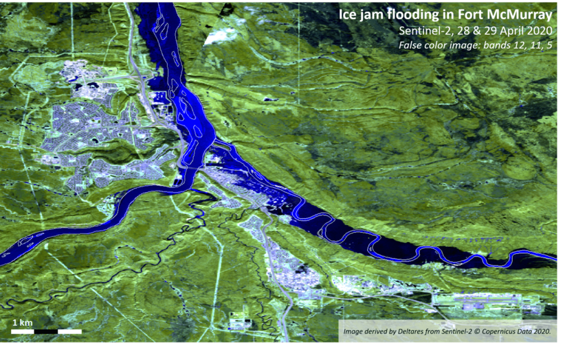 Image:
This false-colour image captured by Copernicus Sentinel-2 shows the extent of an ice jam on the Athabasca River in Canada - leading to the flooding of Fort McMurray.
Image:
This false-colour image captured by Copernicus Sentinel-2 shows the extent of an ice jam on the Athabasca River in Canada - leading to the flooding of Fort McMurray.
Vyhlášení platnosti - pozemková úprava v k. ú. Skalka u Blíževedel
28.5.2020 9:16 ČÚZK - předpisy a opatření Katastrální úřad pro Liberecký kraj - Katastrální pracoviště Česká Lípazveřejnil novou aktualitu: Dne 27. 5. 2020 byla vyhlášena platnost obnoveného katastrálního operátu na podkladě výsledků komplexní pozemkové úpravy v katastrálním území Skalka u Blíževedel. Podrobnosti viz úřední deska.
Vyhlášení platnosti - pozemková úprava v k. ú. Skalka u Blíževedel
28.5.2020 9:16 ČÚZK /Urady/Katastralni-urady/Katastralni-urady/Katastralni-urad-pro-Liberecky-kraj/Katastralni-pracoviste/KP-Ceska-Lipa/O-uradu/Aktuality/Vyhlaseni-platnosti-pozemkova-uprava-v-k-u-SkaPřeřušení provozu Sbírky listin ve čtvrtek 4.6.2020 od 16:30 do cca 19:30
28.5.2020 7:28 Dálkový přístup k údajům KN ČR Vážení uživatelé,oznamujeme, že z provozních důvodů nebude ve čtvrtek 4.6.2020 od 16:30 do cca 19:30 dostupné poskytování dokumentů ze Sbírky listin.
Za komplikace tímto způsobené se omlouváme a děkujeme za pochopení.
Přeřušení provozu Sbírky listin ve čtvrtek 4.6.2020 od 16:30 do cca 19:30
28.5.2020 7:28 ČÚZK /Aplikace-DP-do-KN/Aplikace-DP-do-KN/Archiv-DP/290349Přeřušení provozu Sbírky listin ve čtvrtek 4.6.2020 od 16:30 do cca 19:30
28.5.2020 7:28 ČÚZK - předpisy a opatření Vážení uživatelé,oznamujeme, že z provozních důvodů nebude ve čtvrtek 4.6.2020 od 16:30 do cca 19:30 dostupné poskytování dokumentů ze Sbírky listin.
Za komplikace tímto způsobené se omlouváme a děkujeme za pochopení.
20200528-Zkoušky ÚOZI
28.5.2020 6:42 ČÚZK - předpisy a opatření Český úřad zeměměřický a katastrální zveřejnil novou aktualitu: Zkoušky ÚOZI se budou konat ve dnech 17. a 18. června 2020.HP Inc. Reports Fiscal 2020 Second Quarter Results
28.5.2020 1:44 GISCafe.com Webcasts-Webinars PALO ALTO, Calif., May 27, 2020 (GLOBE NEWSWIRE) -- HP (NYSE: HPQ) Second quarter GAAP diluted net earnings per share ("EPS") of $0.53, above the …Autodesk, Inc. Announces Fiscal 2021 First Quarter Results
28.5.2020 1:44 GISCafe.com Webcasts-Webinars - First Quarter, Year-over-Year Revenue growth of 20 percentSAN RAFAEL, Calif., May 27, 2020 — (PRNewswire) — Autodesk, Inc. …
SOLV3D Garners New Esri Specialty and Becomes a Marketplace Provider
28.5.2020 1:35 GISCafe.com Webcasts-Webinars CALGARY, AB – May 28, 2020 – SOLV3D, a leading provider of 3D processing, geospatial data visualization and collaboration solutions, is …OmniSci Welcomes SafeGraph and Veraset to Its Data Catalog, Providing POI/GPS Data for Commercial, Business, Government
27.5.2020 19:54 GISCafe.com Webcasts-Webinars Two Partner Companies Allow OmniSci Users to Analyze Populations and Their Movement Patterns at Stores, Airports, Shopping Malls, Office Buildings …Prius Intelli Opens Doors to Finely Detailed and Affordable Aerial Imagery
27.5.2020 19:54 GISCafe.com Webcasts-Webinars FT. WORTH, Texas, May 27, 2020 (GLOBE NEWSWIRE) -- The need for clear, detailed surface imagery in planning infrastructure has rendered standard …ASPRS GEO WEEK 2020 TECHNICAL PROGRAM IS GOING VIRTUAL IN JUNE!
27.5.2020 19:54 GISCafe.com Webcasts-Webinars Bethesda, MD May 27, 2020: The American Society for Photogrammetry and Remote Sensing: The Imaging and Geospatial Information Society announces its …Sapcorda and u-blox partner around SPARTN correction interface for delivery of SAPA GNSS augmentation services
27.5.2020 18:51 GISCafe.com Webcasts-Webinars Mass market industrial and automotive applications will be among those to benefit from the scalable, affordable, and high quality positioning …Automated Farming: XAG Introduces Rice Seeding Drone to Mitigate Labour Shortage
27.5.2020 17:16 GISCafe.com Webcasts-Webinars GUANGZHOU, China, May 27, 2020 — (PRNewswire) — With the farming population decreasing and growing older, the global food system now …IoT asset tracking helps move RAIL industry forward
27.5.2020 16:59 GISCafe.com Webcasts-Webinars May 27, 2020 -- Euclideon’s advanced IoT real-time tracking capability is set to revolutionise the worldwide RAIL industry. In addition to …KGItalk #9: Aljaška – zlato, které se vždy neleskne
27.5.2020 16:30 Katedra geoinformatiky UP OlomoucDalší KGItalk bude pod vedením dalšího speciálního hosta přímo z National Geographic. RNDr. Hynek Adámek je český geograf, novinář a publicista pracující jako externí redaktor časopisu National Geographic Česko. Autor knih Živá Afrika, Island – soulad předpokladů nebo Češi v Antarktidě, projel skoro celý svět. Kromě toho je prvním hostem KGItalk, který je na Wikipedii […]
The post KGItalk #9: Aljaška – zlato, které se vždy neleskne appeared first on Katedra geoinformatiky.
Ozn o vyhl výběrového řízení DO
27.5.2020 13:39 ČÚZK - předpisy a opatření Katastrální úřad pro Plzeňský kraj Katastrální pracoviště Domažlicevypisuje výběrové řízení na místo
Ozn o vyhl výběrového řízení DO
Ozn o vyhl výběrového řízení DO
27.5.2020 13:39 ČÚZK - volná místa Katastrální úřad pro Plzeňský kraj Katastrální pracoviště Domažlice vypisuje výběrové řízení na místo Ozn o vyhl výběrového řízení DOOzn o vyhl výběrového řízení DO
27.5.2020 13:39 ČÚZK /Urady/Katastralni-urady/Katastralni-urady/Katastralni-urad-pro-Plzensky-kraj/Uredni-deska/Oznameni-a-jina-uredni-sdeleni/Volna-mista/DMS/Ozn-o-vyhl-vyberoveho-rizeni-DOVýběrové řízení
27.5.2020 13:15 ČÚZK - předpisy a opatření Katastrální úřad pro Plzeňský kraj - Katastrální pracoviště Domažlice zveřejnil novou aktualitu: Ředitelka Katastrálního úřadu pro Plzeňský kraj vyhlašuje výběrové řízení na služební místo odborný referent/vrchní referent – poskytování informací KN – PIKN0401, Katastrální úřad pro Plzeňský kraj, Katastrální pracoviště Domažlice.Výběrové řízení
27.5.2020 13:15 ČÚZK - předpisy a opatření Katastrální úřad pro Plzeňský kraj - Katastrální pracoviště Domažlice zveřejnil novou aktualitu: Ředitelka Katastrálního úřadu pro Plzeňský kraj vyhlašuje výběrové řízení na služební místo odborný referent/vrchní referent – poskytování informací KN – PIKN0401, Katastrální úřad pro Plzeňský kraj, Katastrální pracoviště Domažlice.Oznámení o vyhl výběrového řízení KP Domažlice
27.5.2020 13:10 ČÚZK /Urady/Katastralni-urady/Katastralni-urady/Katastralni-urad-pro-Plzensky-kraj/Uredni-deska/Oznameni-a-jina-uredni-sdeleni/Volna-mista/DMS/Oznameni-o-vyhl-vyberoveho-rizeni-KP-DomazliceOznámení o vyhl výběrového řízení KP Domažlice
27.5.2020 13:10 ČÚZK - volná místa Katastrální úřad pro Plzeňský kraj Katastrální pracoviště Domažlice vypisuje výběrové řízení na místo Oznámení o vyhl výběrového řízení KP DomažliceOznámení o vyhl výběrového řízení KP Domažlice
27.5.2020 13:10 ČÚZK - předpisy a opatření Katastrální úřad pro Plzeňský kraj Katastrální pracoviště Domažlicevypisuje výběrové řízení na místo
Odborný referent/vrchní referent – poskytování informací KN – PIKN0401
Vyhlášení výběrového řízení
27.5.2020 11:39 ČÚZK /Urady/Katastralni-urady/Katastralni-urady/Katastralni-urad-pro-Karlovarsky-kraj/Katastralni-pracoviste/KP-Sokolov/O-uradu/Aktuality/Vyhlaseni-vyberoveho-rizeniVyhlášení výběrového řízení
27.5.2020 11:39 ČÚZK - předpisy a opatření Katastrální úřad pro Karlovarský kraj - Katastrální pracoviště Sokolov zveřejnil novou aktualitu: V části "Úřední deska", v sekci "Oznámení a jiná úřední sdělení" bylo vystaveno "Oznámení o vyhlášení výběrového řízení na obsazení služebního místa Rada / odborný rada oddělení právních vztahů k nemovitostem".ArcRevue 1/2020
27.5.2020 10:23 ARCDATA
S drobným zpožděním kvůli jarní výjimečné situaci jsme vydali první letošní číslo časopisu ArcRevue. Jeho elektronickou PDF verzi si můžete stáhnout na našich stránkách. Naleznete v něm zajímavé články o GIS v Litvínově, databázi Data50 Zeměměřického úřadu či o tom, jak výuka GIS na univerzitě pomohla se zlepšením života v jedné městské části.
Poskytování údajů 28.5.
27.5.2020 10:21 ČÚZK /Urady/Katastralni-urady/Katastralni-urady/Katastralni-urad-pro-Liberecky-kraj/Katastralni-pracoviste/KP-Jablonec-nad-Nisou/O-uradu/Aktuality/Poskytovani-udaju-28-5Poskytování údajů 28.5.
27.5.2020 10:21 ČÚZK - předpisy a opatření Katastrální úřad pro Liberecký kraj - Katastrální pracoviště Jablonec nad Nisouzveřejnil novou aktualitu: Dne 28. 5. 2020 bude z technických důvodů uzavřeno poskytování údajů z KN. Děkujeme za pochopení.
EGNOS goes from strength to strength
27.5.2020 9:59 European GNSS Agency
EGNOS, the European Geostationary Navigation Overlay Service, has been augmenting the GPS signal and providing services to users in Europe since its initial operations back in June 2005. About to celebrate its 15th anniversary, the system is going from strength to strength, with its coverage area set to expand and work towards the next generation EGNOS V3 well underway.
EGNOS is Europe's regional satellite-based augmentation system. It is used to improve the performance of GPS and, with the launch of EGNOS V3, will augment Galileo signals also. EGNOS information improves the accuracy and reliability of GNSS positioning information while also providing a crucial integrity message and transmitting an accurate time signal.
Benefitting numerous markets
The EGNOS programme is managed by the European GNSS Agency (GSA) on behalf of the European Commission. EGNOS service provision is handled by the European Satellite Services Provider (ESSP) under a contract signed with the GSA back in 2013. Based on this, the EGNOS programme currently provides three core services.
Watch this: EGNOS is growing
The first of these, the Open Service (OS), aims to improve the positioning accuracy by correcting error sources affecting the GPS signals. The EGNOS Safety of Life (SoL) Service provides the most stringent level of signal-in-space performance to all SoL user communities and, finally, the EGNOS Data Access Service (EDAS) is aimed at users who require enhanced performance for commercial and professional use.
The provision of EGNOS services is bringing benefits to numerous market segments, including road, rail, maritime, surveying/mapping, location-based services and agriculture. EGNOS is particularly important for sectors and applications where accuracy and integrity are critical, such as the aviation sector. But, beyond aviation, EGNOS also improves and extends the scope of GNSS applications such as precision farming, on-road vehicle management and port and inland waterway navigation, to name but a few.
Set to expand
Currently providing corrections and integrity information in a broad area centred over Europe, the EGNOS coverage area is set to expand. The European Commission has set aside some EUR 8 million from the European Neighbourhood Instrument for the Eastern Partnership countries (Armenia, Azerbaijan, Belarus, Georgia, Moldova, Ukraine), allowing Ukraine to benefit from the same EGNOS high-quality services and cutting-edge technology as the EU Member States.
And this: EGNOS for Aviation
The EGNOS extension to Ukraine will be operational from 2026-27. This extension will allow Eastern Partnership countries to benefit from more accurate positioning and greater safety, in turn contributing to the digitalization and greening of their economies, as well as to the creation of a Single Transport Area for the EU and its Neighbourhood. The extension is complementary to the EGNOS extension to the Southern Neighbourhood countries, which is also being financed by the European Commission.
EGNOS V3
Since it took over the management of the EGNOS Exploitation programme in 2014, the GSA has started to prepare the complete overhaul of the EGNOS ground segment, which will see the deployment of EGNOS V3 in ground stations at more than 50 sites in Europe and its neighbouring countries.
Within EGNOS V3, the GSA also requested the development of new EGNOS capabilities to support the augmentation of a second GPS signal (L5) and of the Galileo signals E1-E5 to be compatible with the new International Civil Aviation Standards. Another requirement is that the system be made more robust, to deal with the increase in user numbers and to reflect their increasing dependence on EGNOS and its multi-modal applications.
Media note: This feature can be republished without charge provided the European GNSS Agency (GSA) is acknowledged as the source at the top or the bottom of the story. You must request permission before you use any of the photographs on the site. If you republish, we would be grateful if you could link back to the GSA website (http://www.gsa.europa.eu).
EGNOS goes from strength to strength
27.5.2020 9:59 European GNSS AgencyEGNOS, the European Geostationary Navigation Overlay Service, has been augmenting the GPS signal and providing services to users in Europe since its initial operations back in June 2005. About to celebrate its 15th anniversary, the system is going from strength to strength, with its coverage area set to expand and work towards the next generation EGNOS V3 well underway.
EGNOS is Europe's regional satellite-based augmentation system. It is used to improve the performance of GPS and, with the launch of EGNOS V3, will augment Galileo signals also. EGNOS information improves the accuracy and reliability of GNSS positioning information while also providing a crucial integrity message.
Benefitting numerous markets
The EGNOS programme is managed by the European GNSS Agency (GSA) on behalf of the European Commission. EGNOS service provision is handled by the European Satellite Services Provider (ESSP) under a contract signed with the GSA back in 2013. Based on this, the EGNOS programme currently provides three core services.
Watch this: EGNOS is growing
The first of these, the Open Service (OS), aims to improve the positioning accuracy by correcting error sources affecting the GPS signals. The EGNOS Safety of Life (SoL) Service provides the most stringent level of signal-in-space performance to all SoL user communities and, finally, the EGNOS Data Access Service (EDAS) (provided via the internet and mobile phones) is aimed at users who require enhanced performance for commercial and professional use.
The provision of EGNOS services is bringing benefits to numerous market segments, including road, rail, maritime, surveying/mapping, and agriculture. EGNOS is particularly important for sectors and applications where accuracy and integrity are critical, such as the aviation sector. But, beyond aviation, EGNOS also improves and extends the scope of GNSS applications such as precision farming, to port and inland waterway navigation, to name but a few.
Set to expand
Currently providing corrections and integrity information in a broad area centred over Europe, the EGNOS coverage area is set to expand. The European Commission has set aside some EUR 8 million from the European Neighbourhood Instrument for the Eastern Partnership countries (Armenia, Azerbaijan, Belarus, Georgia, Moldova, Ukraine), allowing Ukraine to benefit from the same EGNOS high-quality services and cutting-edge technology as the EU Member States.
And this: EGNOS for Aviation
The EGNOS extension to Ukraine will be operational from 2026-27. This extension will allow Eastern Partnership countries to benefit from more accurate positioning and greater safety, in turn contributing to the digitalization and greening of their economies, as well as to the creation of a Single Transport Area for the EU and its Neighbourhood countires. The extension is complementary to the EGNOS extension to the Southern Neighbourhood countries, which is also being financed by the European Commission.
EGNOS V3
Since it took over the management of the EGNOS in 2014, the GSA has started to prepare the complete overhaul of the EGNOS ground segment, which will see the deployment of EGNOS V3 in ground stations at more than 50 sites in Europe and its neighbouring countries.
Within EGNOS V3, the GSA also requested the development of new EGNOS capabilities to support the augmentation of a second GPS signal (L5) and of the Galileo signals E1-E5 to be compatible with the new International Civil Aviation Standards. Another requirement is that the system be made more robust, to deal with users increasing dependence on EGNOS and its multi-modal applications.
Media note: This feature can be republished without charge provided the European GNSS Agency (GSA) is acknowledged as the source at the top or the bottom of the story. You must request permission before you use any of the photographs on the site. If you republish, we would be grateful if you could link back to the GSA website (http://www.gsa.europa.eu).
EGNOS goes from strength to strength
27.5.2020 9:59 European GNSS AgencyEGNOS, the European Geostationary Navigation Overlay Service, has been augmenting the GPS signal and providing services to users in Europe since its initial operations back in June 2005. About to celebrate its 15th anniversary, the system is going from strength to strength, with its coverage area set to expand and work towards the next generation EGNOS V3 well underway.
EGNOS is Europe's regional satellite-based augmentation system. It is used to improve the performance of GPS and, with the launch of EGNOS V3, will augment Galileo signals also. EGNOS information improves the accuracy and reliability of GNSS positioning information while also providing a crucial integrity message.
Benefitting numerous markets
The EGNOS programme is managed by the European GNSS Agency (GSA) on behalf of the European Commission. EGNOS service provision is handled by the European Satellite Services Provider (ESSP) under a contract signed with the GSA back in 2013. Based on this, the EGNOS programme currently provides three core services.
Watch this: EGNOS is growing
The first of these, the Open Service (OS), aims to improve the positioning accuracy by correcting error sources affecting the GPS signals. The EGNOS Safety of Life (SoL) Service provides the most stringent level of signal-in-space performance to all SoL user communities and, finally, the EGNOS Data Access Service (EDAS) (provided via the internet and mobile phones) is aimed at users who require enhanced performance for commercial and professional use.
The provision of EGNOS services is bringing benefits to numerous market segments, including road, rail, maritime, surveying/mapping, and agriculture. EGNOS is particularly important for sectors and applications where accuracy and integrity are critical, such as the aviation sector. But, beyond aviation, EGNOS also improves and extends the scope of GNSS applications such as precision farming, road vehicle management and port and inland waterway navigation, to name but a few.
Set to expand
Currently providing corrections and integrity information in a broad area centred over Europe, the EGNOS coverage area is set to expand. The European Commission has set aside some EUR 8 million from the European Neighbourhood Instrument for the Eastern Partnership countries (Armenia, Azerbaijan, Belarus, Georgia, Moldova, Ukraine), allowing Ukraine to benefit from the same EGNOS high-quality services and cutting-edge technology as the EU Member States.
And this: EGNOS for Aviation
The EGNOS extension to Ukraine will be operational from 2026-27. This extension will allow Eastern Partnership countries to benefit from more accurate positioning and greater safety, in turn contributing to the digitalization and greening of their economies, as well as to the creation of a Single Transport Area for the EU and its Neighbourhood countires. The extension is complementary to the EGNOS extension to the Southern Neighbourhood countries, which is also being financed by the European Commission.
EGNOS V3
Since it took over the management of the EGNOS in 2014, the GSA has started to prepare the complete overhaul of the EGNOS ground segment, which will see the deployment of EGNOS V3 in ground stations at more than 50 sites in Europe and its neighbouring countries.
Within EGNOS V3, the GSA also requested the development of new EGNOS capabilities to support the augmentation of a second GPS signal (L5) and of the Galileo signals E1-E5 to be compatible with the new International Civil Aviation Standards. Another requirement is that the system be made more robust, to deal with users increasing dependence on EGNOS and its multi-modal applications.
Media note: This feature can be republished without charge provided the European GNSS Agency (GSA) is acknowledged as the source at the top or the bottom of the story. You must request permission before you use any of the photographs on the site. If you republish, we would be grateful if you could link back to the GSA website (http://www.gsa.europa.eu).
EGNOS goes from strength to strength
27.5.2020 9:59 European GNSS AgencyEGNOS, the European Geostationary Navigation Overlay Service, has been augmenting the GPS signal and providing services to users in Europe since its initial operations back in June 2005. About to celebrate its 15th anniversary, the system is going from strength to strength, with its coverage area set to expand and work towards the next generation EGNOS V3 well underway.
EGNOS is Europe's regional satellite-based augmentation system. It is used to improve the performance of GPS and, with the launch of EGNOS V3, will augment Galileo signals also. EGNOS information improves the accuracy and reliability of GNSS positioning information while also providing a crucial integrity message.
Benefitting numerous markets
The EGNOS programme is managed by the European GNSS Agency (GSA) on behalf of the European Commission. EGNOS service provision is handled by the European Satellite Services Provider (ESSP) under a contract signed with the GSA back in 2013. Based on this, the EGNOS programme currently provides three core services.
Watch this: EGNOS is growing
The first of these, the Open Service (OS), aims to improve the positioning accuracy by correcting error sources affecting the GPS signals. The EGNOS Safety of Life (SoL) Service provides the most stringent level of signal-in-space performance to all SoL user communities and, finally, the EGNOS Data Access Service (EDAS) (provided via the internet and mobile phones) is aimed at users who require enhanced performance for commercial and professional use.
The provision of EGNOS services is bringing benefits to numerous market segments, including road, rail, maritime, surveying/mapping, and agriculture. EGNOS is particularly important for sectors and applications where accuracy and integrity are critical, such as the aviation sector. But, beyond aviation, EGNOS also improves and extends the scope of GNSS applications such as precision farming, to port and inland waterway navigation, to name but a few.
Set to expand
Currently providing corrections and integrity information in a broad area centred over Europe, the EGNOS coverage area is set to expand. The European Commission has set aside some EUR 8 million from the European Neighbourhood Instrument for the Eastern Partnership countries (Armenia, Azerbaijan, Belarus, Georgia, Moldova, Ukraine), allowing them to benefit from the same EGNOS high-quality services and cutting-edge technology as the EU Member States.
And this: EGNOS for Aviation
The EGNOS extension to the Eastern Neighbourhood will be operational from 2026-27. This extension will allow Eastern Partnership countries to benefit from more accurate positioning and greater safety, in turn contributing to the digitalization and greening of their economies, as well as to the creation of a Single Transport Area for the EU and its Neighbourhood countires. The extension is complementary to the EGNOS extension to the Southern Neighbourhood countries, which is also being financed by the European Commission.
EGNOS V3
Since it took over the management of the EGNOS in 2014, the GSA has started to prepare the complete overhaul of the EGNOS ground segment, which will see the deployment of EGNOS V3 in ground stations at more than 50 sites in Europe and its neighbouring countries.
Within EGNOS V3, the GSA also requested the development of new EGNOS capabilities to support the augmentation of a second GPS signal (L5) and of the Galileo signals E1-E5 to be compatible with the new International Civil Aviation Standards. Another requirement is that the system be made more robust, to deal with users increasing dependence on EGNOS and its multi-modal applications.
Media note: This feature can be republished without charge provided the European GNSS Agency (GSA) is acknowledged as the source at the top or the bottom of the story. You must request permission before you use any of the photographs on the site. If you republish, we would be grateful if you could link back to the GSA website (http://www.gsa.europa.eu).
Oznameni_o_vyhlaseni_vyberoveho_rizeni_KPSO
27.5.2020 9:10 ČÚZK - volná místa Katastrální úřad pro Karlovarský kraj Katastrální pracoviště Sokolov vypisuje výběrové řízení na místo Oznameni_o_vyhlaseni_vyberoveho_rizeni_KPSOOznameni_o_vyhlaseni_vyberoveho_rizeni_KPSO
27.5.2020 9:10 ČÚZK /Urady/Katastralni-urady/Katastralni-urady/Katastralni-urad-pro-Karlovarsky-kraj/Uredni-deska/Oznameni-a-jina-uredni-sdeleni/Volna-mista/DMS/Oznameni_o_vyhlaseni_vyberoveho_rizeni_KPSOOznameni_o_vyhlaseni_vyberoveho_rizeni_KPSO
27.5.2020 9:10 ČÚZK - předpisy a opatření Katastrální úřad pro Karlovarský kraj Katastrální pracoviště Sokolovvypisuje výběrové řízení na místo
rada/odborný rada – oddělení právních vztahů k nemovitostem
Volná místa - 27.05.2020
27.5.2020 8:26 ČÚZK - předpisy a opatření Katastrální úřad pro hlavní město Prahu - Katastrální pracoviště Praha zveřejnil novou aktualitu: Volná místa:* odborný referent/vrchní referent – zápis do protokolu řízení V a Z
Podrobnosti zde
Volná místa - 27.05.2020
27.5.2020 8:26 ČÚZK /Urady/Katastralni-urady/Katastralni-urady/Katastralni-urad-pro-hlavni-mesto-Prahu/O-uradu/Aktuality/Volna-mista-27-05-2020Volná místa - 27.05 až 09.06.2020
27.5.2020 8:26 ČÚZK - předpisy a opatření Katastrální úřad pro hlavní město Prahu - Katastrální pracoviště Praha zveřejnil novou aktualitu: Volná místa:* odborný referent/vrchní referent – zápis do protokolu řízení V a Z
Podrobnosti zde
Volná místa - 27.05 až 09.06.2020
27.5.2020 8:26 ČÚZK /Urady/Katastralni-urady/Katastralni-urady/Katastralni-urad-pro-hlavni-mesto-Prahu/O-uradu/Aktuality/Volna-mista-27-05-2020Slavnostní vysvěcení kaple Panny Marie Ustavičné pomoci v Horšovském Týnu
27.5.2020 0:00 Státní pozemkový úřad Domažlice, 27. 5. 2020: Kaple Panny Marie Ustavičné pomoci v Horšovském Týnu prošla v loňském roce rekonstrukcí a nyní bude vysvěcena váženým panem monsignorem Tomášem Holubem, biskupem plzeňské diecéze. Slavnostní polní mše začne v sobotu 6. června ve 14 hodin. Po skončení obřadu připravili pořadatelé „Procházku s Procházkou“, při které vás Zdeněk Procházka se svým výkladem doprovodí na Loretu. Součástí „Procházky s Procházkou“ bude i návštěva otevřené Loretánské kaple, kde krátce promluví o zámeckém parku i pan inženýr Richard Kolek z Národního památkové ústavu - Hrad a zámek Horšovský Týn. „Procházku s Procházkou“ zakončí slovem pokoje a naděje P. Marek Badida.Annual Home Price Gains Increased To 4.4% In March According To S&P Corelogic Case-Shiller Index
26.5.2020 18:08 GISCafe.com Webcasts-Webinars NEW YORK, May 26, 2020 — (PRNewswire) — S&P Dow Jones Indices today released the latest results for the S&P CoreLogic …Enview Raises $12M in Oversubscribed Round of Funding
26.5.2020 18:08 GISCafe.com Webcasts-Webinars SAN FRANCISCO, May 26, 2020 — (PRNewswire) — Enview, a pioneer in the scalable processing of 3D geospatial data, today announced that …Airbus wins ESA contract to construct third European Service Module for NASA’s Orion spacecraft
26.5.2020 17:00 GISCafe.com Webcasts-Webinars Bremen, 26 May 2020 – The European Space Agency (ESA) has signed a contract with Airbus for the construction of the third European Service …Map of the Month: GfK Purchasing Power, Switzerland 2020
26.5.2020 16:54 GISCafe.com Webcasts-Webinars GfK's Map of the Month for May shows the regional distribution of purchasing power in Switzerland in 2020.According to GfK's latest study …
Clinton County Contracts with Woolpert for STREAM:RASTER Imagery Hosting Service
26.5.2020 16:21 GISCafe.com Webcasts-Webinars The subscription software will house and support the Ohio county's orthoimagery in the cloud, while reducing maintenance costs.WILMINGTON, Ohio, May …
Draganfly Signs Preferred Flight Services Agreement with Windfall Geotek
26.5.2020 16:21 GISCafe.com Webcasts-Webinars Los Angeles, CA, May 26, 2020 (GLOBE NEWSWIRE) -- Draganfly Inc. (CSE: DFLY) (OTCQB: DFLYF) (FSE: 3U8) (“Draganfly” or the “Company”), an …odborný referent/vrchní referent – zápis do protokolu řízení V a Z
26.5.2020 13:41 ČÚZK - volná místa Katastrální úřad pro hlavní město Prahu kancelář ředitele vypisuje výběrové řízení na místo odborný referent/vrchní referent – zápis do protokolu řízení V a Zodborný referent/vrchní referent – zápis do protokolu řízení V a Z
26.5.2020 13:41 ČÚZK /Urady/Katastralni-urady/Katastralni-urady/Katastralni-urad-pro-hlavni-mesto-Prahu/Uredni-deska/Oznameni-a-jina-uredni-sdeleni/Volna-mista/DMS/odborny-referent-vrchni-referent-–-zapis-do-protokodborný referent/vrchní referent – zápis do protokolu řízení V a Z
26.5.2020 13:41 ČÚZK - předpisy a opatření Katastrální úřad pro hlavní město Prahu kancelář ředitelevypisuje výběrové řízení na místo
odborný referent/vrchní referent – zápis do protokolu řízení V a Z
20200526 Rada / odborný rada oddělení právních vztahů k nemovitostem
26.5.2020 10:51 ČÚZK - předpisy a opatření Katastrální úřad pro Středočeský kraj - Katastrální pracoviště Benešov Vyhlášení výběrového řízení: Rada / odborný rada oddělení právních vztahů k nemovitostem V části "Úřední deska", v sekci "Oznámení a jiná úřední sdělení" bylo vystaveno "Oznámení o vyhlášení výběrového řízení na obsazení služebního místa Rada / odborný rada oddělení právních vztahů k nemovitostem"20200526 Rada / odborný rada oddělení právních vztahů k nemovitostem
26.5.2020 10:51 ČÚZK /Urady/Katastralni-urady/Katastralni-urady/Katastralni-urad-pro-Stredocesky-kraj/Katastralni-pracoviste/KP-Benesov/O-uradu/Aktuality/20200526-Rada-odborny-rada-oddeleni-pravnich-vzt20200526 Rada / odborný rada oddělení právních vztahů k nemovitostem
26.5.2020 10:49 ČÚZK /Urady/Katastralni-urady/Katastralni-urady/Katastralni-urad-pro-Stredocesky-kraj/O-uradu/Aktuality/20200526-Rada-odborny-rada-oddeleni-pravnich-vzt20200526 Rada / odborný rada oddělení právních vztahů k nemovitostem
26.5.2020 10:49 ČÚZK - předpisy a opatření Katastrální úřad pro Středočeský kraj - Katastrální pracoviště Benešov Vyhlášení výběrového řízení: Rada / odborný rada oddělení právních vztahů k nemovitostem V části "Úřední deska", v sekci "Oznámení a jiná úřední sdělení" bylo vystaveno "Oznámení o vyhlášení výběrového řízení na obsazení služebního místa Rada / odborný rada oddělení právních vztahů k nemovitostem"Rada / odborný rada oddělení právních vztahů k nemovitostem
26.5.2020 10:48 ČÚZK - předpisy a opatření Katastrální úřad pro Středočeský kraj - Katastrální pracoviště Benešovvypisuje výběrové řízení na místo Rada / odborný rada oddělení právních vztahů k nemovitostem
Rada / odborný rada oddělení právních vztahů k nemovitostem
Rada / odborný rada oddělení právních vztahů k nemovitostem
26.5.2020 10:48 ČÚZK - volná místa Katastrální úřad pro Středočeský kraj - Katastrální pracoviště Benešov vypisuje výběrové řízení na místo Rada / odborný rada oddělení právních vztahů k nemovitostemRada / odborný rada oddělení právních vztahů k nemovitostem
26.5.2020 10:48 ČÚZK /Urady/Katastralni-urady/Katastralni-urady/Katastralni-urad-pro-Stredocesky-kraj/Uredni-deska/Oznameni-a-jina-uredni-sdeleni/Volna-mista/Rada-odborny-rada-oddeleni-pravnich-vztahu-k-n-(6)Rada / odborný rada – vedoucí oddělení právních vztahů k nemovitostem Katastrálního pracoviště Uhers
26.5.2020 10:36 ČÚZK - volná místa Katastrální úřad pro Zlínský kraj Katastrální pracoviště Uherské Hradiště vypisuje výběrové řízení na místo Rada / odborný rada – vedoucí oddělení právních vztahů k nemovitostem Katastrálního pracoviště UhersRada / odborný rada – vedoucí oddělení právních vztahů k nemovitostem Katastrálního pracoviště Uhers
26.5.2020 10:36 ČÚZK - předpisy a opatření Katastrální úřad pro Zlínský kraj Katastrální pracoviště Uherské Hradištěvypisuje výběrové řízení na místo
Rada / odborný rada – vedoucí oddělení právních vztahů k nemovitostem Katastrálního pracoviště Uherské Hradiště
Rada / odborný rada – vedoucí oddělení právních vztahů k nemovitostem Katastrálního pracoviště Uhers
26.5.2020 10:36 ČÚZK /Urady/Katastralni-urady/Katastralni-urady/Katastralni-urad-pro-Zlinsky-kraj/Uredni-deska/Oznameni-a-jina-uredni-sdeleni/Volna-mista/DMS/Rada-odborny-rada-–-vedouci-oddeleni-pravnich-vzKotlíkové dotace - III. výzva
26.5.2020 10:30 Středočeský kraj Byla vypublikována nová mapová aplikace Kotlíkové dotace - III. výzva, která nabízí základní přehled o aktuálním stavu přijatých žádostí v rámci projektu III. výzvy Kotlíkových dotací. Zároveň nabízí prostorovou analýzu, která odpovídá na otázku, jaký podíl obyvatelstva za obec má zájem o dotaci. V mapě si lze zapnout i další vrstvy, jako např. vrstvu tzv. Prioritních obcí nebo vrstvu Oblasti se zhoršenou kvalitou ovzduší. Uživatel přes nástroj Vybrat si může zobrazit podrobnější informace i za konkrétní obec. Zdrojem aplikace je veřejně dostupná excelová tabulka, která je jednou měsíčně aktualizována Odborem řízení dotačních projektů. Cílem aplikace je pomocí nástrojů geografického informačního systému ukázat statistická data jednoduše a přehledně prostřednictvím interaktivní mapy. Aplikace volně navazuje na webovou prezentaci Kotlíkové odtace - II. výzva z roku 2018. Aplikace je postavena na produktu ArcGIS Dashboards a připravil ji Odbor informatiky / GIS.20200526 Odborný / vrchní referent oddělení aktualizace katastru nemovitostí
26.5.2020 10:26 ČÚZK /Urady/Katastralni-urady/Katastralni-urady/Katastralni-urad-pro-Stredocesky-kraj/Katastralni-pracoviste/KP-Mlada-Boleslav/O-uradu/Aktuality/20200526-Odborny-vrchni-referent-oddeleni-aktual20200526 Odborný / vrchní referent oddělení aktualizace katastru nemovitostí
26.5.2020 10:26 ČÚZK - předpisy a opatření Katastrální úřad pro Středočeský kraj - Katastrální pracoviště Mladá Boleslav Vyhlášení výběrového řízení: Odborný / vrchní referent oddělení aktualizace katastru nemovitostí V části "Úřední deska", v sekci "Oznámení a jiná úřední sdělení" bylo vystaveno "Oznámení o vyhlášení výběrového řízení na obsazení služebního místa Odborný / vrchní referent oddělení aktualizace katastru nemovitostí"20200526 Odborný / vrchní referent oddělení aktualizace katastru nemovitostí
26.5.2020 10:24 ČÚZK - předpisy a opatření Katastrální úřad pro Středočeský kraj - Katastrální pracoviště Mladá Boleslav Vyhlášení výběrového řízení: Odborný / vrchní referent oddělení aktualizace katastru nemovitostí V části "Úřední deska", v sekci "Oznámení a jiná úřední sdělení" bylo vystaveno "Oznámení o vyhlášení výběrového řízení na obsazení služebního místa Odborný / vrchní referent oddělení aktualizace katastru nemovitostí"20200526 Odborný / vrchní referent oddělení aktualizace katastru nemovitostí
26.5.2020 10:24 ČÚZK /Urady/Katastralni-urady/Katastralni-urady/Katastralni-urad-pro-Stredocesky-kraj/O-uradu/Aktuality/20200526-Odborny-vrchni-referent-oddeleni-aktualOdborný / vrchní referent oddělení aktualizace katastru nemovitostí
26.5.2020 10:22 ČÚZK - volná místa Katastrální úřad pro Středočeský kraj - Katastrální pracoviště Mladá Boleslav vypisuje výběrové řízení na místo Odborný / vrchní referent oddělení aktualizace katastru nemovitostíOdborný / vrchní referent oddělení aktualizace katastru nemovitostí
26.5.2020 10:22 ČÚZK - předpisy a opatření Katastrální úřad pro Středočeský kraj - Katastrální pracoviště Mladá Boleslavvypisuje výběrové řízení na místo Odborný / vrchní referent oddělení aktualizace katastru nemovitostí
Odborný / vrchní referent oddělení aktualizace katastru nemovitostí
Odborný / vrchní referent oddělení aktualizace katastru nemovitostí
26.5.2020 10:22 ČÚZK /Urady/Katastralni-urady/Katastralni-urady/Katastralni-urad-pro-Stredocesky-kraj/Uredni-deska/Oznameni-a-jina-uredni-sdeleni/Volna-mista/Odborny-vrchni-referent-oddeleni-aktualizace-kat20200526 Odborný / vrchní referent oddělení dokumentace KN
26.5.2020 10:10 ČÚZK /Urady/Katastralni-urady/Katastralni-urady/Katastralni-urad-pro-Stredocesky-kraj/Katastralni-pracoviste/KP-Melnik/O-uradu/Aktuality/20200526-Odborny-vrchni-referent-oddeleni-dokume20200526 Odborný / vrchní referent oddělení dokumentace KN
26.5.2020 10:10 ČÚZK - předpisy a opatření Katastrální úřad pro Středočeský kraj - Katastrální pracoviště Mělník Vyhlášení výběrového řízení: Odborný / vrchní referent oddělení dokumentace KN V části "Úřední deska", v sekci "Oznámení a jiná úřední sdělení" bylo vystaveno "Oznámení o vyhlášení výběrového řízení na obsazení služebního místa Odborný / vrchní referent oddělení dokumentace KN"20200526 Odborný / vrchní referent oddělení dokumentace KN
26.5.2020 10:08 ČÚZK - předpisy a opatření Katastrální úřad pro Středočeský kraj - Katastrální pracoviště Mělník Vyhlášení výběrového řízení: Odborný / vrchní referent oddělení dokumentace KN V části "Úřední deska", v sekci "Oznámení a jiná úřední sdělení" bylo vystaveno "Oznámení o vyhlášení výběrového řízení na obsazení služebního místa Odborný / vrchní referent oddělení dokumentace KN"20200526 Odborný / vrchní referent oddělení dokumentace KN
26.5.2020 10:08 ČÚZK /Urady/Katastralni-urady/Katastralni-urady/Katastralni-urad-pro-Stredocesky-kraj/O-uradu/Aktuality/20200526-Odborny-vrchni-referent-oddeleni-dokumeOdborný / vrchní referent oddělení dokumentace KN
26.5.2020 10:04 ČÚZK /Urady/Katastralni-urady/Katastralni-urady/Katastralni-urad-pro-Stredocesky-kraj/Uredni-deska/Oznameni-a-jina-uredni-sdeleni/Volna-mista/Odborny-vrchni-referent-oddeleni-dokumentace-KNOdborný / vrchní referent oddělení dokumentace KN
26.5.2020 10:04 ČÚZK - volná místa Katastrální úřad pro Středočeský kraj - Katastrální pracoviště Mělník vypisuje výběrové řízení na místo Odborný / vrchní referent oddělení dokumentace KNOdborný / vrchní referent oddělení dokumentace KN
26.5.2020 10:04 ČÚZK - předpisy a opatření Katastrální úřad pro Středočeský kraj - Katastrální pracoviště Mělníkvypisuje výběrové řízení na místo Odborný / vrchní referent oddělení dokumentace KN
Odborný / vrchní referent oddělení dokumentace KN
Webinář Pocitové mapy a netradiční využtí GIS v obcích
26.5.2020 7:00 Česká asociace pro geoinformace Zítra 27. 5. 2020 se uskuteční zajímavý webinář s názvem Pocitové mapy a netradiční využití GIS v obcích. Ve webináři představí Jiří Pánek (spoluzakladatel projektu PocitoveMapy.cz) možnosti využívání geografických informačních systémů a geoparticipace v plánování a řízení obcí. Víc informací naleznete na webu https://www.zdravamesta.cz/cz/webinare nebo naVýběrové řízení
26.5.2020 6:30 ČÚZK - předpisy a opatření Katastrální úřad pro Plzeňský kraj - Katastrální pracoviště Plzeň-město zveřejnil novou aktualitu: Ředitelka Katastrálního úřadu pro Plzeňský kraj vyhlašuje výběrové řízení na služební místo rada/odborný rada – vedoucí oddělení aktualizace KN – VOA10, Katastrální úřad pro Plzeňský kraj, Katastrální pracoviště Plzeň-město.Výběrové řízení
26.5.2020 6:30 ČÚZK - předpisy a opatření Katastrální úřad pro Plzeňský kraj - Katastrální pracoviště Plzeň-město zveřejnil novou aktualitu: Ředitelka Katastrálního úřadu pro Plzeňský kraj vyhlašuje výběrové řízení na služební místo rada/odborný rada – vedoucí oddělení aktualizace KN – VOA10, Katastrální úřad pro Plzeňský kraj, Katastrální pracoviště Plzeň-město.Výběrové řízení
26.5.2020 6:30 ČÚZK /Urady/Katastralni-urady/Katastralni-urady/Katastralni-urad-pro-Plzensky-kraj/O-uradu/Aktuality/Vyberove-rizeni-(4)Rada/odborný rada – vedoucí oddělení aktualizace KN – VOA10
26.5.2020 6:25 ČÚZK - předpisy a opatření Katastrální úřad pro Plzeňský kraj Katastrální pracoviště Plzeň-městovypisuje výběrové řízení na místo
Rada/odborný rada – vedoucí oddělení aktualizace KN – VOA10
Rada/odborný rada – vedoucí oddělení aktualizace KN – VOA10
26.5.2020 6:25 ČÚZK /Urady/Katastralni-urady/Katastralni-urady/Katastralni-urad-pro-Plzensky-kraj/Uredni-deska/Oznameni-a-jina-uredni-sdeleni/Volna-mista/DMS/Rada-odborny-rada-–-vedouci-oddeleni-aktualizace-KRada/odborný rada – vedoucí oddělení aktualizace KN – VOA10
26.5.2020 6:25 ČÚZK - volná místa Katastrální úřad pro Plzeňský kraj Katastrální pracoviště Plzeň-město vypisuje výběrové řízení na místo Rada/odborný rada – vedoucí oddělení aktualizace KN – VOA10Archiv báňsko-historické dokumentace Kutná Hora
26.5.2020 2:00 Cenia - Katalog metadat ČR - INSPIRE Digitální kartotéka, která obsahuje publikace a další materiály vztahující se k problematice hornictví, geologickým vědám a historii. Publikace jsou uložené v odborné knihovně na pracovišti České geologické služby v Kutné HořeIntetics Inc. Introduces New Corporate Style and Celebrates 25 Years Anniversary: Time to Refresh
25.5.2020 22:38 GISCafe.com Webcasts-Webinars Intetics Inc announces new corporate style in the celebration of its anniversaryNAPLES, Fla., May 25, 2020 — (PRNewswire) —
NAPLES, …
rada/ odborný rada v právním oddělení odboru právních vztahů k nemovitostem
25.5.2020 17:08 ČÚZK /Urady/Katastralni-urady/Katastralni-urady/Katastralni-urad-pro-Stredocesky-kraj/Volna-mista/rada-odborny-rada-v-pravnim-oddeleni-odboru-pr-(1)rada/ odborný rada v právním oddělení odboru právních vztahů k nemovitostem
25.5.2020 17:08 ČÚZK - volná místa Katastrální úřad pro Středočeský kraj - Katastrální pracoviště Praha-západ vypisuje výběrové řízení na místo rada/ odborný rada v právním oddělení odboru právních vztahů k nemovitostemrada/ odborný rada v právním oddělení odboru právních vztahů k nemovitostem
25.5.2020 17:08 ČÚZK - předpisy a opatření Katastrální úřad pro Středočeský kraj - Katastrální pracoviště Praha-západvypisuje výběrové řízení na místo rada/ odborný rada v právním oddělení odboru právních vztahů k nemovitostem
rada/ odborný rada v právním oddělení odboru právních vztahů k nemovitostem
Z důvodu změn na serverech ČÚZ
25.5.2020 15:47 GEUSware Z důvodu změn na serverech ČÚZK, přestaly v GEUSu fungovat funkce: Stahování mapových listů pro typ mapy "Bodová pole", Mapové služby WMS - rastrová wms "Bodové pole", Geodetické údaje bodu přes WMS a Kontrola údajů bodu přes WMS.Usilovně pracujeme na opravě, nové sestavení programu bude uvolněno během následujících dní.
Galileo Masters international kick-off, don’t miss it!
25.5.2020 14:44 European GNSS Agency
This year’s online International Kick-off of the Galileo Masters and Copernicus Masters will take place with a webinar on 26 May highlighting how space data can support human lives, health and development. Don’t miss this opportunity to meet with high-level representatives from both competitions, along with stakeholders from the broader partner community of 121 organisations from 34 countries. Sounds interesting? Register now!
Every year the Galileo Masters and Copernicus Masters International Kick-off brings together representatives from key institutional and industrial players that shape the Galileo and Copernicus Masters – the biggest innovation eco-system of the European Space Programme.
This year is no different. In particular, the GSA’s Head of Market Development Fiammetta Diani and Marta Krywanis-Brzostowska, Head of Downstream R&D in the GSA Market Development Department, will be on hand at the webinar to give tips and guidance. The webinar will take place at 10:30-13:30 (CEST) on 26 May.
Read this: Raw Measurements Workshop: Registration now open!
“The International Kick-off is an ideal opportunity to give impetus to your idea and find advice and help in taking it to the next level. So, if you are an innovator, start-up, SME, researcher, student, developer or just a space enthusiast, we look forward to welcoming you to our online event,” Diani said.
Ready for a challenge?
The 2020 edition of the Galileo Masters opened for submissions back in April and the GSA is sponsoring three challenges in this year’s competition. The Space for Being Safe and Healthy Challenge is looking for solutions that use downstream space data provided by Galileo, EGNOS and/or Copernicus to help stem the spread of COVID-19. Have an idea? Let us hear about it!
In its Space for Fun Challenge, the GSA is targeting solutions using data from Galileo and EGNOS in the gaming, sports, leisure and tourism markets. Covering a number of market segments, this challenge has a lot of scope for new ideas that need accurate and authenticated positioning information. Have an application in mind? Sign up here!
And this: Galileo for wearables
Finally, the Space for our Planet Challenge, aims to tackle climate change and environmental degradation, which represent an existential threat in Europe and worldwide. Have an idea about how to save the planet? Let us know about it.
We look forward to welcoming you online on 26 May 2020!
Media note: This feature can be republished without charge provided the European GNSS Agency (GSA) is acknowledged as the source at the top or the bottom of the story. You must request permission before you use any of the photographs on the site. If you republish, we would be grateful if you could link back to the GSA website (http://www.gsa.europa.eu).