


![]()

zprávy
zdroje zpráv:20200512 - Pozastavení organizace školení ISÚI
18.5.2020 14:36 ČÚZK - předpisy a opatření Vzhledem k současným vládním opatřením v souvislosti s pandemií COVID-19 bude možné praktická školení ISÚI a semináře RÚIAN zorganizovat nejdříve v 09/2020.20200512 - Pozastavení organizace školení ISÚI
18.5.2020 14:36 ČÚZK - předpisy a opatření Vzhledem k současným vládním opatřením v souvislosti s pandemií COVID-19 bude možné praktická školení ISÚI a semináře RÚIAN zorganizovat nejdříve v 09/2020.Nový Zpravodaj ČKS
18.5.2020 14:19 Katedra geoinformatiky UP OlomoucNový Zpravodaj České Kartografické Společnosti je dostupný zde: 2020-02_Zpravodaj-CKS
The post Nový Zpravodaj ČKS appeared first on Katedra geoinformatiky.
Nové číslo Zpravodaje (2/2020)
18.5.2020 11:20 Česká kartografická společnost Přinášíme Vám nové číslo Zpravodaje České kartografické společnosti. Přejeme příjemné čtení!Nové číslo Zpravodaje (2/2020)
18.5.2020 11:20 Česká kartografická společnost Přinášíme Vám nové číslo Zpravodaje České kartografické společnosti. Prolistovat si jej můžete níže i online. Přejeme příjemné čtení!Czech Republic drought visible from space
18.5.2020 9:30 ESA Observing the Earth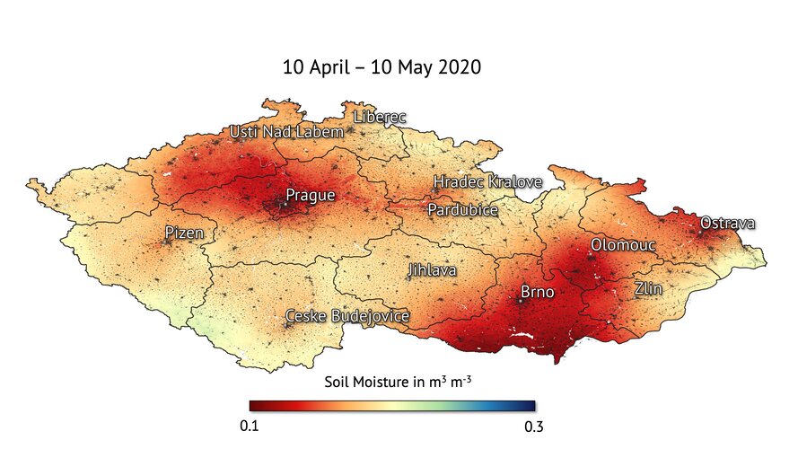
The prolonged period of dry weather in the Czech Republic has resulted in what experts are calling the ‘worst drought in 500 years.’ Scientists are using ESA satellite data to monitor the drought that’s gripped the country.
Czech Republic drought visible from space
18.5.2020 9:30 ESA Observing the Earth
The prolonged period of dry weather in the Czech Republic has resulted in what experts are calling the ‘worst drought in 500 years.’ Scientists are using ESA satellite data to monitor the drought that’s gripped the country.
Odborný referent - poskytování informací KN, poskytování podkladů, nahlížení do KN, poskytování PK v
18.5.2020 9:05 ČÚZK - volná místa Katastrální úřad pro Zlínský kraj Katastrální pracoviště Uherský Brod vypisuje výběrové řízení na místo Odborný referent - poskytování informací KN, poskytování podkladů, nahlížení do KN, poskytování PK vOdborný referent - poskytování informací KN, poskytování podkladů, nahlížení do KN, poskytování PK v
18.5.2020 9:05 ČÚZK - předpisy a opatření Katastrální úřad pro Zlínský kraj Katastrální pracoviště Uherský Brodvypisuje výběrové řízení na místo
Odborný referent - poskytování informací KN, poskytování podkladů, nahlížení do KN, poskytování PK v oddělení dokumentace KN KP Uherský Brod
Odborný referent - poskytování informací KN, poskytování podkladů, nahlížení do KN, poskytování PK v
18.5.2020 9:05 ČÚZK /Urady/Katastralni-urady/Katastralni-urady/Katastralni-urad-pro-Zlinsky-kraj/Uredni-deska/Oznameni-a-jina-uredni-sdeleni/Volna-mista/DMS/Odborny-referent-poskytovani-informaci-KN,-poskyInterview with Brian Smith, Senior VP of Strategy & Innovation, Geodecisions - a GISCafe Bunker Broadcast
18.5.2020 9:00 GISCafe.com Webcasts-Webinars20200518 - Geodetický a kartografický obzor (5/2020)
18.5.2020 8:50 ČÚZK - předpisy a opatření Český úřad zeměměřický a katastrální zveřejnil novou aktualitu: Aktuální číslo Geodetického a kartografického obzoru (5/2020) je k dispozici ke stažení.20200518 - Geodetický a kartografický obzor (5/2020)
18.5.2020 8:50 ČÚZK /Aktuality-resort/2020/20200518-Geodeticky-a-kartograficky-obzor-(5-202
Nové číslo GaKO
18.5.2020 8:40
ÚGKK SR
Nové číslo časopisu Geodetického a Kartografického Obzoru 05/2020
ČHMÚ nabízí data ke stažení, ALE…
18.5.2020 8:32 GISportal.cz
V souladu se zákonem 123/1998 Sb. o právu na informace o životním prostředí ČHMÚ zpřístupnil denní, měsíční a roční klimatologické charakteristiky naměřené na stanicích ve správě ČHMÚ za období 1961-2019. Touto krátkou zprávou uvedl ČHMÚ relativně převratnou novinku a to, že jejich data jsou konečně volně dostupná. Má to ale háček! Ve chvíli, kdy si […]
The post ČHMÚ nabízí data ke stažení, ALE… appeared first on GISportal.cz.
EDIT: ČHMÚ nabízí data ke stažení, ALE…
18.5.2020 8:32 GISportal.czEDIT: Matěj Man z AV ČR sepsal několik skriptů k automatickému dolování dat. V souladu se zákonem 123/1998 Sb. o právu na informace o životním prostředí ČHMÚ zpřístupnil denní, měsíční a roční klimatologické charakteristiky naměřené na stanicích ve správě ČHMÚ za období 1961-2019. Touto krátkou zprávou uvedl ČHMÚ relativně převratnou novinku a to, že jejich […]
The post EDIT: ČHMÚ nabízí data ke stažení, ALE… appeared first on GISportal.cz.
Evaluace výuky
18.5.2020 7:39 Katedra geoinformatiky UP OlomoucStudenti, ohodnoťte výuku❗️ Zpětná vazba je důležitá a my se chceme zlepšovat 🙂 https://eval.upol.cz/StudentEvaluation
The post Evaluace výuky appeared first on Katedra geoinformatiky.
KU-05547_2020-770-01001-1_VR_UBRO
18.5.2020 7:31 ČÚZK - předpisy a opatření Katastrální úřad pro Zlínský kraj, Katastrální pracoviště Uherský Brodvypisuje výběrové řízení na místo
KU-05547_2020-770-01001-1_VR_UBRO
KU-05547_2020-770-01001-1_VR_UBRO
18.5.2020 7:31 ČÚZK - předpisy a opatření Katastrální úřad pro Zlínský kraj, Katastrální pracoviště Uherský Brod Katastrální pracoviště Uherský Brodvypisuje výběrové řízení na místo
Odborný referent - poskytování informací KN, poskytování podkladů, nahlížení do KN, poskytování PK v oddělení dokumentace KN KP Uherský Brod
KU-05547_2020-770-01001-1_VR_UBRO
18.5.2020 7:31 ČÚZK - volná místa Katastrální úřad pro Zlínský kraj, Katastrální pracoviště Uherský Brod Katastrální pracoviště Uherský Brod vypisuje výběrové řízení na místo KU-05547_2020-770-01001-1_VR_UBROKonference GIS Esri v ČR
18.5.2020 7:00 Česká asociace pro geoinformace Tradiční konference GIS Esri v ČR se bude konat 4. a 5. listopadu 2020. Zatím není jasné, v jakém formátu, a konat se bude rozhodně. Aktuální informace přitom budou vždy k dispozici na oficiální stránce konferenceKonec nouzového stavu
18.5.2020 0:00 Státní pozemkový úřad Od pondělí 18. května 2020 se vrací všechna pracoviště Státního pozemkového úřadu do běžného provozu. Nadále však platí bezpečnostní vládní opatření. Prosíme, vstupujete na pracoviště se zakrytým nosem i ústy, při vstupu a odchodu použijte dezinfekci. Pokud pociťujete příznaky respirační choroby, odložte návštěvu na dobu po uzdravení. Děkujeme.Konec nouzového stavu
18.5.2020 0:00 Státní pozemkový úřad Od pondělí 17. května 2020 se vrací všechna pracoviště Státního pozemkového úřadu do běžného provozu. Nadále však platí bezpečnostní vládní opatření. Prosíme, vstupujete na pracoviště se zakrytým nosem i ústy, při vstupu a odchodu použijte dezinfekci. Pokud pociťujete příznaky respirační choroby, odložte návštěvu na dobu po uzdravení. Děkujeme.Uzavření Pobočky Strakonice
18.5.2020 0:00 Státní pozemkový úřad Z důvodu odstávky pitné vody bude v úterý 19. května 2020 uzavřena Pobočka Strakonice. Děkujeme za pochopení.Uzavření Pobočky Strakonice
18.5.2020 0:00 Státní pozemkový úřad Z důvodu odstávky pitné vody bude v úterý 19. května 2020 uzavřena Pobočka Strakonice. Děkujeme za pochopení.Tenure track position “Geospatial analysis of access to urban amenities” at Vrije Universiteit Brussel
17.5.2020 9:09 Tenure track position “Geospatial analysis of access to urban amenities” at Vrije Universiteit Brussel Application deadline: 30 May 2020 Recruitment is a tenure track appointment which implies an initial appointment as lecturer for a period of 5 years with eligibility for tenure in the rank of senior lecturer by the end of this initial period. […]"Mapping Hot Spots Using Satellites to Prepare for UK Summer Heatwave" by Susan Smith
17.5.2020 8:16 GISCafe.com Webcasts-WebinarsVyzkoušejte si nventorCA
16.5.2020 8:14 Adeon![]() Vyzkoušejte si nventorCAM na měsíc s nejnižšími možnými náklady.
Vyzkoušejte si nventorCAM na měsíc s nejnižšími možnými náklady.
New Members Join HawkEye 360's Advisory Board
16.5.2020 0:56 GISCafe.com Webcasts-Webinars Terry McAuliffe and Chris Inglis contribute decades of government and defense expertiseHERNDON, Va., May 15, 2020 — (PRNewswire) — …
Sapcorda to introduce program for GNSS augmentation service integrators
15.5.2020 22:00 GISCafe.com Webcasts-Webinars (PresseBox) ( Berlin, 14.05.20 )Sapcorda Services GmbH (“Sapcorda”) today announced the release of its SAPA augmentation service …
Interview with Rich Weber, President at Panzura systems - a GISCafe Bunker Broadcast
15.5.2020 17:54 GISCafe.com Webcasts-WebinarsSeen from space: COVID-19 and the environment
15.5.2020 17:12 ESA Observing the Earth Video:
00:04:00
Video:
00:04:00
As the COVID-19 pandemic has disrupted lives across the globe, Earth-observing satellites take the pulse of our planet from space. While the global lockdown has had a massive impact on daily life and the economy, there have been environmental benefits that are visible from space. How can we preserve these positives when returning to ‘business as usual’?
This video includes an interview in English with Josef Aschbacher, Director of Earth Observation Programmes.
Pointfuse and Leica Geosystems announce a new software and global cooperation that drives automation in the management of the built environment
15.5.2020 16:44 GISCafe.com Webcasts-Webinars May 15, 2020 -- Pointfuse Limited and Leica Geosystems, a Hexagon company, are delighted to announce the start of a global cooperation and …MGISS Equips Critical Infrastructure Workers During COVID-19 Lockdown
15.5.2020 16:42 GISCafe.com Webcasts-Webinars May 15, 2020 -- Mobile GIS Services (MGISS) is supporting asset owners and contractors who maintain critical infrastructure during the Coronavirus …Copernicus Hackathon Bari 2020. The online competition for innnovators and developers.
15.5.2020 16:41 GISCafe.com Webcasts-Webinars May 15, 2020 -- The Copernicus Hackathon is back! Following last year's success, the Copernicus Hackathon 2020, promoted and coordinated by the …Intermap Announces Update on Continuous Disclosure Obligations
15.5.2020 16:37 GISCafe.com Webcasts-Webinars DENVER, May 14, 2020 — (PRNewswire) — Intermap Technologies ("Intermap" or the "Company"), a global leader in geospatial intelligence …Autonomous Drones are Now Delivering Defibrillators to 80,000 Residents in Sweden
15.5.2020 16:37 GISCafe.com Webcasts-Webinars GOTHENBURG, Sweden, May 15, 2020 — (PRNewswire) — Everdrone, a global leader in autonomous drone technology, today announced it is …AgEagle Aerial Systems Reports Record Revenue in First Quarter 2020
15.5.2020 16:37 GISCafe.com Webcasts-Webinars NEODESHA, Kan., May 15, 2020 (GLOBE NEWSWIRE) -- AgEagle Aerial Systems Inc. (NYSE American: UAVS), an industry leading provider of unmanned aerial …Earth from Space: San Francisco Bay
15.5.2020 10:00 ESA Observing the Earth Video:
00:00:00
Video:
00:00:00
In this week's edition of the Earth from Space programme, the Copernicus Sentinel-2 mission takes us over San Francisco Bay in the US state of California.
See also San Francisco Bay to download the image.
San Francisco Bay
15.5.2020 10:00 ESA Observing the Earth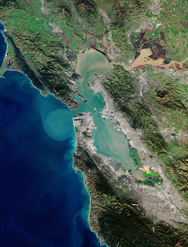 Image:
The Copernicus Sentinel-2 mission takes us over San Francisco Bay in the US state of California.
Image:
The Copernicus Sentinel-2 mission takes us over San Francisco Bay in the US state of California.
Mapová aplikace ÚPD - nové dokumentace
15.5.2020 9:45 Jihočeský kraj V mapové aplikaci Územně plánovací dokumentace obcí byla aktualizována územně plánovací dokumentace obcí v ORP Třeboň – Rapšach; ORP České Budějovice – Rudolfov; ORP Strakonice – Strakonice; ORP Prachatice – Lenora; ORP Soběslav – Borkovice, Sedlečko u Soběslavě; ORP Jindřichův Hradec – Staré Město pod Landštejnem a v ORP Český Krumlov – Nová Ves.Woolpert's Sam Moffat Named President of Tennessee Geographic Information Council
15.5.2020 9:00 GISCafe.com Webcasts-Webinars The geospatial program director and senior associate has worked with the state GIS council since 2001.KNOXVILLE, Tenn., May 14, 2020 — …
Pronájem dočasně nepotřebného pozemku
15.5.2020 8:48 ČÚZK /Urady/Katastralni-urady/Katastralni-urady/Katastralni-urad-pro-Stredocesky-kraj/Nabidky-majetku/Pronajem-docasne-nepotrebneho-pozemkuPronájem dočasně nepotřebného pozemku
15.5.2020 8:48 ČÚZK - předpisy a opatřeníKatastrální úřad pro Středočeský kraj nabízí pronájem dočasně nepotřebného pozemku
Pronájem dočasně nepotřebného pozemku
Oznámení o provozu katastrálních pracovišť:
15.5.2020 8:16 ČÚZK - předpisy a opatření Katastrální úřad pro Jihočeský kraj zveřejnil novou aktualitu: Oznámení o provozu katastrálních pracovišť:Na všech katastrálních pracovištích v územní působnosti Katastrálního úřadu pro Jihočeský kraj skončilo omezení úředních hodin.
Dovolujeme si upozornit, že podání lze uskutečnit i prostřednictvím provozovatele poštovních služeb nebo elektronicky (e-mailem nebo prostřednictvím datových schránek). Podrobnosti o elektronických podáních a parametrech přijímaných datových zpráv zde: https://www.cuzk.cz/Katastr-nemovitosti/Zapisy-do-KN/Informace-o-elektronickem-podani.aspx.
Základní informace z katastru nemovitostí je možné získat rovněž elektronicky prostřednictvím aplikace Nahlížení do katastru nemovitostí: https://nahlizenidokn.cuzk.cz/, jejímž prostřednictvím je možné získat i úplný výpis z katastru nemovitostí v elektronické podobě bez nutnosti návštěvy katastrálního pracoviště.
Neodkladná jiná ústní jednání je možno realizovat pouze po předchozí telefonické domluvě výhradně v úředních hodinách.
Dále upozorňujeme, že i nadále platí zákaz pohybu klientů mimo prostory klientských center a i nadále je nutno dodržovat bezpečnostní opatření stanovená usnesením vlády ČR (zakrytí dýchacích cest rouškou, dodržování stanovených odstupů).
Oznámení o provozu katastrálních pracovišť:
15.5.2020 8:16 ČÚZK /Urady/Katastralni-urady/Katastralni-urady/Katastralni-urad-pro-Jihocesky-kraj/O-uradu/Aktuality/Oznameni-o-provozu-katastralnich-pracovist-(1)Uživatelské konference Esri v Praze a San Diegu budou
15.5.2020 8:01 GISportal.cz
Uživatelské konference Esri v Praze a San Diegu budou, sice každá v jiném formátu, ale ani o jednu z tradičních akcí letos nepřijdeme. Světová Esri konference – 13. – 15. července 2020 S ohledem na celosvětový výjimečný stav bude letošní ročník uživatelské konference Esri uspořádán virtuálně. Prostřednictvím videopřenosů, interaktivních výstav a celé řady dalších aktivit, díky kterým […]
The post Uživatelské konference Esri v Praze a San Diegu budou appeared first on GISportal.cz.
KM Dačice
15.5.2020 7:53 ČÚZK /Urady/Katastralni-urady/Katastralni-urady/Katastralni-urad-pro-Jihocesky-kraj/Katastralni-pracoviste/KP-Jindrichuv-Hradec/Uredni-hodiny/KM-DaciceSeznam.cz má svůj digitální atlas světa. Při jeho tvorbě bylo použito 92 datových zdrojů
15.5.2020 7:35 GeoBusinessFirma Seznam.cz spustila na serveru Mapy.cz samostatnou webovou stránku atlas.mapy.cz, na níž najdete interaktivní digitální atlas světa. Atlas je určený především pro školáky na druhém stupni základních škol a jejich učitele, takže se dá touto cestou učit zeměpis online, ale může je používat každý, kdo chce vidět svět v souvislostech. Ve spolupráci s učiteli připravil […]
The post Seznam.cz má svůj digitální atlas světa. Při jeho tvorbě bylo použito 92 datových zdrojů appeared first on GeoBusiness.
INSPIRE téma Rozšířené Parcely (CPX)
15.5.2020 2:00 Cenia - Katalog metadat ČR - INSPIRE Rozšíření má za cíl poskytovat katastrální mapu s obsahem podle vyhlášky ve vektorové podobě ve struktuře plně v souladu se strukturou danou směrnicí INSPIRE. Data rozšiřují směrnici INSPIRE pro téma katastrální parcely (CP) o věcná břemena, geodetické body, další prvky mapy, původní obloukovou geometrii a o parcely určené definičním bodem (ty pouze v oblastech s analogovou mapou). Vychází z katastrální mapy, která je závazným státním mapovým dílem velkého měřítka, obsahuje body polohového bodového pole, polohopis a popis a může mít formu digitální mapy, analogové mapy nebo digitalizované mapy. Publikovaná data obsahují katastrální území pro celou Českou Republiku, parcely a jejich hranice, věcná břemena, další prvky mapy a původní obloukovou geometrii z území, kde je digitální mapa (k 11. 05. 2020 je to 96,76% území České republiky, t.j. 76 307,75km2) a ve zbytku území katastrální parcely určené pouze definičním bodem (tedy bez hranic a polygonu). Katastrální parcely a hranice obsahují oproti datové sadě INSPIRE některé atributy navíc. Jedná se o typ hranice, způsob využití území, druh pozemku, vazbu na budovu a o mapové značky. Více katastrální zákon 344/1992 SB., katastrální vyhláška č.26/2007 Sb. v platném znění a INSPIRE Data Specification on Cadastral Parcels v 3.0.1. Data ve formátu GML 3.2.1 jsou validní proti schématu XML pro Rozšířené Parcely (CPX) ve verzi 4.0.Katastrální mapa ve formátech DGN a DXF poskytovaná v e-shopu
15.5.2020 2:00 Cenia - Katalog metadat ČR - INSPIRE Katastrální mapa je závazným státním mapovým dílem velkého měřítka, obsahuje body polohového bodového pole, polohopis a popis. Katastrální mapa ve vektorové podobě je poskytována zdarma ve formátu DGN a DXF a obsahuje prvky Digitální katastrální mapy (DKM) a Katastrální mapy digitalizované (KMD), tedy bodová pole, budovy, další prvky mapy, hranice parcel, katastrální hranice, parcely katastru nemovitostí, prvky orientační mapy a hranice věcného břemene. Z důvodu použití formátu DGN produkt neobsahuje značky na liniích a oblouky jsou nahrazeny lomenými čárami. Katastrální mapa ve vektorové podobě k 11. 05. 2020 pokrývá 96,76% území České republiky, t.j. 76 307,75km2. Více katastrální vyhláška č.357/2013 Sb. v platném znění.INSPIRE téma Budovy (BU)
15.5.2020 2:00 Cenia - Katalog metadat ČR - INSPIRE Data odpovídají směrnici INSPIRE pro téma budovy (BU). Data pochází částečně z projektu RÚIAN (Registr územní identifikace, adres a nemovitostí), který je součástí základních registrů České Republiky a obsahuje informace o územní identifikaci, adresách a nemovitostech, a částečně z ISKN (Informační systém katastru nemovistostí). Zdrojem informací o budovách v ISKN je objekt Stavba, v RÚIAN je to Stavební objekt. Většina Staveb je zároveň Stavebními objekty, ale jsou případy, kdy tomu tak není. Kromě Budov datová sada obsahuje i části budov, které jsou pro potřeby INSPIRE vyjádřeny vchody z RÚIAN. Vchody obsahují informace o počtu podlaží, technickoekonomických atributech apod. Datová sada pokrývá celé území české republiky. V datové sadě není uvedeno 1,14%, t.j. 48342 budov (k 11. 05. 2020), protože neobsahují definiční bod ani polygon. Více v zákoně č. 111/2009 Sb., o základních registrech, ve vyhlášce č. 359/2011 Sb., o základním registru územní identifikace, adres a nemovitostí v platných zněních, v zákoně 256/2013 Sb., o katastru nemovitostí, v katastrální vyhlášce č. 357/2013 Sb. v platném znění a INSPIRE Data Specification on Buildings v 3.0 z 13.12.2013. Data ve formátu GML 3.2.1 jsou validní proti schématu XML pro INSPIRE téma Budovy ve verzi 4.0 a proti schématu pro prostorová data ELF ve verzi 1.0.INSPIRE téma Adresy (AD)
15.5.2020 2:00 Cenia - Katalog metadat ČR - INSPIRE Data odpovídají směrnici INSPIRE pro téma adresy (AD). Vychází především z projektu RÚIAN (Registr územní identifikace, adres a nemovitostí), který je součástí základních registrů České Republiky a obsahuje informace o územní identifikaci, adresách a nemovitostech. Data publikovaná v rámci INSPIRE obsahují pouze adresní místa a jejich komponenty, kterými jsou stát, obec, část obce, městský obvod v Praze (MOP), městký obvod/městská část (MO/MČ), ulice a pošta a to na území celé České Republiky. Obsahují rozvněž geometrii, která určuje definiční bod adresního místa. V datové sadě nění uvedeno 1,16%, t.j. 34206 adresních míst (k 11. 05. 2020), protože neobsahují definiční bod, podle kterého by je bylo možné prostorově určit. Více v zákoně č. 111/2009 Sb., o základních registrech a ve vyhlášce č. 359/2011 Sb., o základním registru územní identifikace, adres a nemovitostí v platných zněních a INSPIRE Data Specification on Addresses v 3.0.1 z 26.4.2010. Data ve formátu GML 3.2.1 jsou validní proti schématu XML pro INSPIRE téma Adresy ve verzi 4.0 a proti schématu pro prostorová data ELF ve verzi 1.0.INSPIRE téma Parcely (CP)
15.5.2020 2:00 Cenia - Katalog metadat ČR - INSPIRE Data odpovídají směrnici INSPIRE pro téma katastrální parcely (CP). Vychází z katastrální mapy, která je závazným státním mapovým dílem velkého měřítka, obsahuje body polohového bodového pole, polohopis a popis a může mít formu digitální mapy, analogové mapy nebo digitalizované mapy. Data publikovaná v rámci INSPIRE obsahují pouze katastrální území (pro celou Českou Republiku) a parcely a jejich hranice z území, kde je digitální mapa (k 11. 05. 2020 je to 96,76% území České republiky, t.j. 76 307,75km2). Více katastrální zákon 344/1992 SB., katastrální vyhláška č.26/2007 Sb. v platném znění a INSPIRE Data Specification on Cadastral Parcels v 3.0.1. Data ve formátu GML 3.2.1 jsou validní proti schématu XML pro INSPIRE téma Parcely ve verzi 4.0 a proti schématu pro prostorová data ELF ve verzi 1.0.VZ: 3,0 mil. Kč – komplexní pozemkové úpravy Odunec
14.5.2020 23:19 ZeměměřičPředmětem plnění podlimitní veřejné zakázky na služby je zpracování návrhu komplexních pozemkových úprav (dále jen „KoPÚ“) v katastrálním území Odunec, včetně nezbytných geodetických prací v třídě přesnosti určené pro obnovu katastru nemovitostí vyhláškou č. 357/2013 Sb. Do obvodu komplexní pozemkové úpravy bude zahrnuto celé katastrální území obce Odunec, mimo zastavěné území obce. Předpokládaná výměra řešeného území je v k. […]
The post VZ: 3,0 mil. Kč – komplexní pozemkové úpravy Odunec appeared first on Zeměměřič.
Podzimní konference GIS Esri v ČR 2020 určitě bude a má termín. Poznačte si jej do kalendáře
14.5.2020 21:53 GeoBusinessKonference GIS Esri v ČR, kterou pořádá firma Arcdata Praha, je počtem účastníků největším setkáním geoinformatiků v České republice. Organizátoři oznámili datum letošního ročníku, tentokrát 4.–5. listopadu 2020. Přestože nelze odhadovat, jak bude na podzim vypadat situace s covid-19, Arcdata Praha sděluje, že konference se uskuteční v každém případě – v ideálním případě fyzicky v […]
The post Podzimní konference GIS Esri v ČR 2020 určitě bude a má termín. Poznačte si jej do kalendáře appeared first on GeoBusiness.
OmniSci Records Best Quarter in Company History
14.5.2020 19:57 GISCafe.com Webcasts-Webinars Accelerated Analytics Leader Increased Revenue, Closed Deals with Top Brands, Including Procter & Gamble and HERE Technologies, and Expanded Global …Climate Scientists Use Wingtra Drones to Predict Flash Flooding of Alaskan Communities
14.5.2020 18:45 GISCafe.com Webcasts-Webinars JUNEAU, Alaska, May 14, 2020 — (PRNewswire) — Just outside Juneau, Alaska, climate researchers are tracking rising and falling ice …Magnetic north and the elongating blob
14.5.2020 16:12 ESA Observing the Earth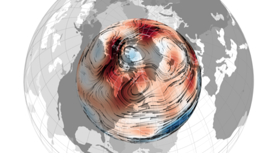
For some years now, scientists have been puzzling over why the north magnetic pole has been making a dash towards Siberia. Thanks, in part, to ESA’s Swarm satellite mission, scientists are now more confident in the theory that tussling magnetic blobs deep below Earth’s surface are at the root of this phenomenon.
Mapová aplikace Investiční akce 2020
14.5.2020 13:30 Jihočeský kraj Byla vytvořena mapová aplikace Investiční akce 2020, zobrazující plánované investiční akce Jihočeského kraje a Správy a údržby silnic JčK na silnicích II. a III. třídy pro rok 2020.Vrchní referent/rada – správce informačních a komunikačních technologií v oddělení podpory ICT techn
14.5.2020 12:15 ČÚZK - volná místa Katastrální úřad pro Královéhradecký kraj vypisuje výběrové řízení na místo Vrchní referent/rada – správce informačních a komunikačních technologií v oddělení podpory ICT technVrchní referent/rada – správce informačních a komunikačních technologií v oddělení podpory ICT techn
14.5.2020 12:15 ČÚZK /Urady/Katastralni-urady/Katastralni-urady/Katastralni-urad-pro-Kralovehradecky-kraj/Uredni-deska/Oznameni-a-jina-uredni-sdeleni/Volna-mista/Vrchni-referent-rada-–-spravce-informacnich-a-(2)Vrchní referent/rada – správce informačních a komunikačních technologií v oddělení podpory ICT techn
14.5.2020 12:15 ČÚZK - předpisy a opatření Katastrální úřad pro Královéhradecký krajvypisuje výběrové řízení na místo
Vrchní referent/rada – správce informačních a komunikačních technologií v oddělení podpory ICT technického útvaru Katastrálního úřadu pro Královéhradecký kraj
Rada/Odborný rada – Metodik oddělení metodiky a kontroly
14.5.2020 12:05 ČÚZK - volná místa Katastrální úřad pro Karlovarský kraj vypisuje výběrové řízení na místo Rada/Odborný rada – Metodik oddělení metodiky a kontrolyRada/Odborný rada – Metodik oddělení metodiky a kontroly
14.5.2020 12:05 ČÚZK /Urady/Katastralni-urady/Katastralni-urady/Katastralni-urad-pro-Karlovarsky-kraj/Uredni-deska/Oznameni-a-jina-uredni-sdeleni/Volna-mista/DMS/Rada-Odborny-rada-–-Metodik-oddeleni-metodiky-a-koRada/Odborný rada – Metodik oddělení metodiky a kontroly
14.5.2020 12:05 ČÚZK - předpisy a opatření Katastrální úřad pro Karlovarský krajvypisuje výběrové řízení na místo
Rada/Odborný rada – Metodik oddělení metodiky a kontroly
Raw Measurements Workshop: Registration now open!
14.5.2020 11:22 European GNSS Agency
Registration is now open for the fourth GNSS Raw Measurements Task Force Workshop, which will take place on 27 and 28 May 2020. Participants in the event, which will be held online due to the current lockdown restrictions in place around Europe, will gain access to Task Force members’ experience and learn about progress around the use of raw measurements in Android devices. Interested? Register here
The aim of the GSA’s Raw Measurements Task Force is to bridge the knowledge gap between raw measurement users. The GNSS Raw Measurements Task Force Workshops are a key element in this effort, providing a forum for stakeholders to share experience and knowledge around raw measurements use.
A full agenda
On the first day, 27 of May, following a welcome address from the GSA’s Head of Market Development Fiammetta Diani, the opening session of the workshop will include a keynote presentation from Google`s Frank Van Diggelen and an overview of opportunities for Android developers from Justyna Redelkiewicz Musial, who is in charge of LBS and IoT market development at the GSA. Xurxo Otero from the European Space Agency will also be on hand to talk about testing of dual-frequency chipsets.
Read this: Hackers take on Raw Galileo challenge
“Using GNSS raw measurements in Android devices brings many benefits to users in terms of accuracy, and provides access to more advanced processing techniques. The workshop is an excellent opportunity to share knowledge around raw measurement use and ensure that the widest possible community of users enjoy these benefits,” Diani said.
The second session during the first day of the workshop will deal with Galileo differentiators when working with GNSS raw measurements. As an example, there will be a presentation from Carlo Sarto from Qascom focusing in detail on OS-NMA in smartphones. On 28 of May, starting again at 15:00 CET in the afternoon, the agenda will be fully dedicated to presentations from Task Force members, targeting their innovative work using raw measurements. For the full agenda, click here.
And this: Latest updates to Reports on User Needs and Requirements released
Join the Task Force
The GNSS Raw Measurements Task Force is dedicated to promoting a better and wider use of GNSS raw measurements.
Since its launch in 2017, the Task Force has expanded from a handful of experts to a community of over 100 agencies, universities, research institutes and companies. Membership is open to anybody interested in GNSS raw measurements. To join the Task Force contact: market@gsa.europa.eu .
Media note: This feature can be republished without charge provided the European GNSS Agency (GSA) is acknowledged as the source at the top or the bottom of the story. You must request permission before you use any of the photographs on the site. If you republish, we would be grateful if you could link back to the GSA website (http://www.gsa.europa.eu).
Raw Measurements Workshop: Registration now open!
14.5.2020 11:22 European GNSS AgencyRegistration is now open for the fourth GNSS Raw Measurements Task Force Workshop, which will take place on 27 and 28 May 2020. Participants in the event, which will be held online due to the current lockdown restrictions in place around Europe, will gain access to Task Force members’ experience and learn about progress around the use of raw measurements in Android devices. Interested? Register here
The aim of the GSA’s Raw Measurements Task Force is to bridge the knowledge gap between raw measurement users. The GNSS Raw Measurements Task Force Workshops are a key element in this effort, providing a forum for stakeholders to share experience and knowledge around raw measurements use.
A full agenda
On the first day, 27 of May, following a welcome address from the GSA’s Head of Market Development Fiammetta Diani, the opening session of the workshop will include a keynote presentation from Google`s Frank Van Diggelen and an overview of opportunities for Android developers from Justyna Redelkiewicz Musial, who is in charge of LBS and IoT market development at the GSA. Xurxo Otero from the European Space Agency will also be on hand to talk about testing of dual-frequency chipsets.
Read this: Hackers take on Raw Galileo challenge
“Using GNSS raw measurements in Android devices brings many benefits to users in terms of accuracy, and provides access to more advanced processing techniques. The workshop is an excellent opportunity to share knowledge around raw measurement use and ensure that the widest possible community of users enjoy these benefits,” Diani said.
The second session during the first day of the workshop will deal with Galileo differentiators when working with GNSS raw measurements. As an example, there will be a presentation from Carlo Sarto from Qascom focusing in detail on OS-NMA in smartphones. On 28 of May, starting again at 15:00 in the afternoon, the agenda will be fully dedicated to presentations from Task Force members, targeting their innovative work using raw measurements. For the full agenda, click here.
And this: Latest updates to Reports on User Needs and Requirements released
Join the Task Force
The GNSS Raw Measurements Task Force is dedicated to promoting a better and wider use of GNSS raw measurements.
Since its launch in 2017, the Task Force has expanded from a handful of experts to a community of over 100 agencies, universities, research institutes and companies. Membership is open to anybody interested in GNSS raw measurements. To join the Task Force contact: market@gsa.europa.eu .
Media note: This feature can be republished without charge provided the European GNSS Agency (GSA) is acknowledged as the source at the top or the bottom of the story. You must request permission before you use any of the photographs on the site. If you republish, we would be grateful if you could link back to the GSA website (http://www.gsa.europa.eu).
Raw Measurements Workshop: Registration now open!
14.5.2020 11:22 European GNSS AgencyRaw Measurements Workshop: Registration now open!
Registration is now open for the fourth GNSS Raw Measurements Task Force Workshop, which will take place on 27 and 28 May 2020. Participants in the event, which will be held online due to the current lockdown restrictions in place around Europe, will gain access to Task Force members’ experience and learn about progress around the use of raw measurements in Android devices. Interested? Register here!
The aim of the GSA’s Raw Measurements Task Force is to bridge the knowledge gap between raw measurement users. The GNSS Raw Measurements Task Force Workshops are a key element in this effort, providing a forum for stakeholders to share experience and knowledge around raw measurements use.
A full agenda
On the first day, 27 of May, following a welcome address from the GSA’s Head of Market Development Fiammetta Diani, the opening session of the workshop will include a keynote presentation from Google`s Frank Van Diggelen and an overview of opportunities for Android developers from Justyna Redelkiewicz Musial, who is in charge of LBS and IoT market development at the GSA. Xurxo Otero from the European Space Agency will also be on hand to talk about testing of dual-frequency chipsets.
Read this: Hackers take on Raw Galileo challenge
“Using GNSS raw measurements in Android devices brings many benefits to users in terms of accuracy, and provides access to more advanced processing techniques. The workshop is an excellent opportunity to share knowledge around raw measurement use and ensure that the widest possible community of users enjoy these benefits,” Diani said.
The second session during the first day of the workshop will deal with Galileo differentiators when working with GNSS raw measurements. As an example, there will be a presentation from Carlo Sarto from Qascom focusing in detail on OS-NMA in smartphones. On 28 of May, starting again at 15:00 in the afternoon, the agenda will be fully dedicated to presentations from Task Force members, targeting their innovative work using raw measurements. For the full agenda, click here.
And this: Latest updates to Reports on User Needs and Requirements released
Join the Task Force
The GNSS Raw Measurements Task Force is dedicated to promoting a better and wider use of GNSS raw measurements.
Since its launch in 2017, the Task Force has expanded from a handful of experts to a community of over 100 agencies, universities, research institutes and companies. Membership is open to anybody interested in GNSS raw measurements. To join the Task Force contact: market@gsa.europa.eu .
Registration is now open for the fourth GNSS Raw Measurements Task Force Workshop, which will take place on 27 and 28 May 2020. Participants in the event, which will be held online due to the current lockdown restrictions in place around Europe, will gain access to Task Force members’ experience and learn about progress around the use of raw measurements in Android devices. Interested? Register here!
Media note: This feature can be republished without charge provided the European GNSS Agency (GSA) is acknowledged as the source at the top or the bottom of the story. You must request permission before you use any of the photographs on the site. If you republish, we would be grateful if you could link back to the GSA website (http://www.gsa.europa.eu).
Raw Measurements Workshop: Registration now open!
14.5.2020 11:22 European GNSS AgencyRegistration is now open for the fourth GNSS Raw Measurements Task Force Workshop, which will take place on 27 and 28 May 2020. Participants in the event, which will be held online due to the current lockdown restrictions in place around Europe, will gain access to Task Force members’ experience and learn about progress around the use of raw measurements in Android devices. Interested? Register here
The aim of the GSA’s Raw Measurements Task Force is to bridge the knowledge gap between raw measurement users. The GNSS Raw Measurements Task Force Workshops are a key element in this effort, providing a forum for stakeholders to share experience and knowledge around raw measurements use.
A full agenda
On the first day, 27 of May, following a welcome address from the GSA’s Head of Market Development Fiammetta Diani, the opening session of the workshop will include a keynote presentation from Google`s Frank Van Diggelen and an overview of opportunities for Android developers from Justyna Redelkiewicz Musial, who is in charge of LBS and IoT market development at the GSA. Xurxo Otero from the European Space Agency will also be on hand to talk about testing of dual-frequency chipsets.
Read this: Hackers take on Raw Galileo challenge
“Using GNSS raw measurements in Android devices brings many benefits to users in terms of accuracy, and provides access to more advanced processing techniques. The workshop is an excellent opportunity to share knowledge around raw measurement use and ensure that the widest possible community of users enjoy these benefits,” Diani said.
The second session during the first day of the workshop will deal with Galileo differentiators when working with GNSS raw measurements. As an example, there will be a presentation from Carlo Sarto from Qascom focusing in detail on OS-NMA in smartphones. On 28 of May, starting again at 15:00 in the afternoon, the agenda will be fully dedicated to presentations from Task Force members, targeting their innovative work using raw measurements. For the full agenda, click here.
And this: Latest updates to Reports on User Needs and Requirements released
Join the Task Force
The GNSS Raw Measurements Task Force is dedicated to promoting a better and wider use of GNSS raw measurements.
Since its launch in 2017, the Task Force has expanded from a handful of experts to a community of over 100 agencies, universities, research institutes and companies. Membership is open to anybody interested in GNSS raw measurements. To join the Task Force contact: market@gsa.europa.eu .
Media note: This feature can be republished without charge provided the European GNSS Agency (GSA) is acknowledged as the source at the top or the bottom of the story. You must request permission before you use any of the photographs on the site. If you republish, we would be grateful if you could link back to the GSA website (http://www.gsa.europa.eu).
Vyhlášení termínu Konference GIS Esri v ČR 2020
14.5.2020 11:20 ARCDATA
Dovolujeme si vás pozvat na letošní ročník Konference GIS Esri v ČR, která se bude konat 4. a 5. listopadu 2020.
V tuto chvíli sice ještě nevíme, jakou formou pro vás budeme moci toto tradiční setkání českých geoinformatiků připravit, ale již nyní vám můžeme slíbit, že konat se bude v každém případě a že se opět můžete těšit na celou řadu inspirativních řečníků, technologických novinek a vzájemného sdílení zkušeností napříč obory.
Organizace letošního ročníku
Ve svých kalendářích si tedy, prosím, rezervujte termín 4.–5. listopadu 2020 a jakmile to bude možné, sdělíme vám další podrobnosti. Aktuální informace přitom budou vždy k dispozici na oficiální stránce konference.
Uživatelské prezentace
Nepostradatelnou součástí našich konferencí jsou samozřejmě i prezentace výsledků vaší práce, a to se nezmění ani letos. Pokud tedy máte nějaký zajímavý projekt, dejte nám o něm určit vědět na e-mail konference@arcdata.cz a my s ním budeme při přípravě programu počítat. Přihlásit nám takto můžete přednášku, poster nebo svoji online aplikaci.
Těšíme se na setkání s vámi.

Rada/Odborný rada – Metodik oddělení metodiky a kontroly
14.5.2020 10:28 ČÚZK - volná místa Katastrální úřad pro Karlovarský kraj vypisuje výběrové řízení na místo Rada/Odborný rada – Metodik oddělení metodiky a kontrolyRada/Odborný rada – Metodik oddělení metodiky a kontroly
14.5.2020 10:28 ČÚZK /Urady/Katastralni-urady/Katastralni-urady/Katastralni-urad-pro-Karlovarsky-kraj/Uredni-deska/Oznameni-a-jina-uredni-sdeleni/Volna-mista/Rada-Odborny-rada-–-Metodik-oddeleni-metodiky-a-koRada/Odborný rada – Metodik oddělení metodiky a kontroly
14.5.2020 10:28 ČÚZK - předpisy a opatření Katastrální úřad pro Karlovarský krajvypisuje výběrové řízení na místo
Rada/Odborný rada – Metodik oddělení metodiky a kontroly
GaKO 5/2020
14.5.2020 7:45 GaKO GaKO 5/2020 HONTI, R.: Automatizovaná segmentácia valcov z údajov získaných terestrickým laserovým skenovaním ŽIVOTSKÁ, K.–KALAŠ, O.: Výsledky průzkumů spokojenosti klientů s poskytovanými službami resortu ČÚZKGaKO 5/2020
14.5.2020 7:45 GaKO GaKO 5/2020 HONTI, R.: Automatizovaná segmentácia valcov z údajov získaných terestrickým laserovým skenovaním ŽIVOTSKÁ, K.–KALAŠ, O.: Výsledky průzkumů spokojenosti klientů s poskytovanými službami resortu ČÚZKModel Zdoňov pro návrat vody do krajiny. Jak by geodeti mohli pomáhat
14.5.2020 7:16 ZeměměřičV aktuálním vydání časopisu Respekt 20/2020 Tomáš Brolík připravil článek “Je pozdě, ale přávě začínáme” (paywall). Popisuje v něm “Model Zdoňov”, který navrací vodu do vysušené krajiny. Projekt zvítězil v kategorii nápad v soutěži E.ON Energy Globe v loňském roce a zároveň vyhrál inkubaci od UP21, který byl partnerem soutěže. Projekt se ve fázi studie proveditelnosti zaměřil na nápravu krajiny […]
The post Model Zdoňov pro návrat vody do krajiny. Jak by geodeti mohli pomáhat appeared first on Zeměměřič.
Model Zdoňov pro návrat vody do krajiny. Jak by geodeti mohli pomáhat
14.5.2020 7:16 ZeměměřičV aktuálním vydání časopisu Respekt 20/2020 Tomáš Brolík připravil článek „Je pozdě, ale přávě začínáme“ (paywall). Popisuje v něm „Model Zdoňov“, který navrací vodu do vysušené krajiny. Projekt zvítězil v kategorii nápad v soutěži E.ON Energy Globe v loňském roce a zároveň vyhrál inkubaci od UP21, který byl partnerem soutěže. Projekt se ve fázi studie proveditelnosti zaměřil na nápravu krajiny […]
The post Model Zdoňov pro návrat vody do krajiny. Jak by geodeti mohli pomáhat appeared first on Zeměměřič.
Model Zdoňov pro návrat vody do krajiny. Jak by mohli geodeti pomoci
14.5.2020 7:16 ZeměměřičV aktuálním vydání časopisu Respekt 20/2020 Tomáš Brolík připravil článek „Je pozdě, ale přávě začínáme“ (paywall). Popisuje v něm „Model Zdoňov“, který navrací vodu do vysušené krajiny. Projekt zvítězil v kategorii nápad v soutěži E.ON Energy Globe v loňském roce a zároveň vyhrál inkubaci od UP21, který byl partnerem soutěže. Projekt se ve fázi studie proveditelnosti zaměřil na nápravu krajiny […]
The post Model Zdoňov pro návrat vody do krajiny. Jak by mohli geodeti pomoci appeared first on Zeměměřič.
Metainformační katalog AOPK ČR
14.5.2020 2:00 Cenia - Katalog metadat ČR - INSPIRE Katalog zpřístupňuje metadata geografických dat a služeb spravovaných a poskytovaných Agenturou ochrany přírody a krajiny ČR.Esri nabízí pro samostudium software zdarma
13.5.2020 19:41 GeoBusinessJako součást podpory uživatelů v době, kdy mnohé společnosti omezily nebo přerušily svůj provoz, zpřístupnila Esri kurzy na stránkách Learn ArcGIS zdarma. Uživatelé tak mohou využívat ArcGIS Online, ArcGIS Pro a přes 20 dalších aplikací pro účely svého vzdělávání. Zájemci, kteří se přihlásí mezi 1. květnem a 30. červnem, získají licenci na software a kurzy do 31. srpna 2020. Na […]
The post Esri nabízí pro samostudium software zdarma appeared first on GeoBusiness.
Zašlete své mapy a aplikace na letošní světovou konferenci Esri
13.5.2020 18:56 GeoBusinessSvětová konference Esri se letos koná virtuálně a je zdarma otevřena pro všechny uživatele Esri s platnou systémovou podporou (maintenance). Společnost Arcdata Praha informovala, že můžete zasílat své mapy a aplikace na soutěžní přehlídku v Galerii map (Map Gallery), případně obrázky pro použití v prezentaci Jacka Dangermonda. Aplikace a mapy na přehlídku posílejte prostřednictvím speciálního formuláře do 5. června 2020. […]
The post Zašlete své mapy a aplikace na letošní světovou konferenci Esri appeared first on GeoBusiness.
Fortem Technologies Enables Safe Unmanned Drone Delivery of Life Saving Medical Supplies to North Carolina’s WakeMed Hospital
13.5.2020 18:52 GISCafe.com Webcasts-Webinars PLEASANT GROVE, UT, May 13, 2020 (GLOBE NEWSWIRE) -- Fortem Technologies, Inc., the market leader of C-UAS security and defense solutions, …XAG Deploys Drones to Seed Burned Land for Australian Fire Recovery
13.5.2020 16:33 GISCafe.com Webcasts-Webinars COBRICO, Australia, May 12, 2020 — (PRNewswire) — In a collective effort to restore Australia from wildfire devastation, XAG has joined …Accela Solutions Enable Manatee County to Process Unprecedented Number of Permits Remotely Amid COVID-19 Crisis
13.5.2020 16:33 GISCafe.com Webcasts-Webinars Cloud-based Building and Planning technology powers the processing of nearly 3,100 permit requests remotely in MarchSAN RAMON, Calif., May 13, 2020 …
M-Files for Esri ArcGIS Integrates Global Mapping Technology and Intelligent Information Management Systems to Provide a Unified User Experience
13.5.2020 16:33 GISCafe.com Webcasts-Webinars Solution delivers fast, in-context access to data, documents and information directly from the M-Files and Esri ArcGIS User InterfacesAUSTIN, Texas, …
Teledyne Optech partners with Aerial Surveys International to provide hyper-realistic mapping solution
13.5.2020 16:32 GISCafe.com Webcasts-Webinars Vaughan, CANADA, May 12, 2020 -- Teledyne Optech, a Teledyne Technologies [NYSE:TDY] company and global leader in advanced lidar sensors, …Galileo in high altitudes and harsh environments: a success story
13.5.2020 15:07 European GNSS Agency
Access to the Galileo signal in a multi-constellation environment is providing benefits and opportunities for businesses, thanks to the enhanced performance and increased accuracy on offer. Here we look at the experience of one GIS technology company in northern Europe that has been leveraging Galileo to increase the positioning accuracy of its solutions.
Use of a Galileo-enabled receiver significantly increases the number of satellites in view. This, in turn, considerably reduces the time needed to obtain a position with centimetre-level accuracy, compared to the performance from single-constellation receivers. Businesses have been eager to incorporate these performance gains into their solutions and pass the benefits on to their customers.
Swedish geographical information technology company SCIOR Geomanagement AB makes use of various technologies, such as drone aerial photography, terrestrial laser scanning, GNSS, or various combinations of these, in its equipment.
As a producer of measurement technology, SCIOR is well aware of the benefits of RTK processing techniques and incorporates this approach to obtain faster and more accurate positions. However, the company also uses Galileo-enabled receivers to increase the positioning accuracy of its solutions even further.
Centimetre-level accuracy
According to the company’s findings, which it presented at the last Intergeo conference in Stuttgart, it has been achieving significantly enhanced performance and other benefits in its day to day activities from the use of Galileo-enabled equipment.
“Our experience with Galileo has shown an improvement in the density of the constellation of visible satellites, and thus an improvement in the time needed to obtain centimetre-level accuracy. From my personal point of view, I would recommend using this constellation in combination with the other existing ones, since it provides you with a better and quicker performance,” said Javier Corral, an engineer at SCIOR Geomanagement AB.
The most significant performance improvements are observed at high latitudes and within forest environments. Even taking into account that better results can be obtained in open spaces, using multi-constellation GNSS with Galileo in the woods is sometimes the only way to obtain a satisfactory performance if there is no reference station close enough.
Good indicator
SCIOR’s testimonial about the benefits of using Galileo in high altitudes and harsh environments serves as a good indicator for other companies working in similar environments. Moreover, performance will be even better in coming years as the number of Galileo satellites increases to reach Full Operation Capability (FOC), allowing users to obtain their desired position accuracy and availability in a shorter period of time.
In the meantime, to continue harnessing the benefits of Galileo and multi-constellation users can register at the European GNSS Service Centre (GSC) or contact the GSC Helpdesk at: www.gsc-europa.eu/helpdesk .
Media note: This feature can be republished without charge provided the European GNSS Agency (GSA) is acknowledged as the source at the top or the bottom of the story. You must request permission before you use any of the photographs on the site. If you republish, we would be grateful if you could link back to the GSA website (http://www.gsa.europa.eu).
Galileo in high latitudes and harsh environments: a success story
13.5.2020 15:07 European GNSS AgencyAccess to the Galileo signal in a multi-constellation environment is providing benefits and opportunities for businesses, thanks to the enhanced performance and increased accuracy on offer. Here we look at the experience of one GIS technology company in northern Europe that has been leveraging Galileo to increase the positioning accuracy of its solutions.
Use of a Galileo-enabled receiver significantly increases the number of satellites in view. This, in turn, considerably reduces the time needed to obtain a position with centimetre-level accuracy, compared to the performance from single-constellation receivers. Businesses have been eager to incorporate these performance gains into their solutions and pass the benefits on to their customers.
Swedish geographical information technology company SCIOR Geomanagement AB makes use of various technologies, such as drone aerial photography, terrestrial laser scanning, GNSS, or various combinations of these, in its equipment.
As a producer of measurement technology, SCIOR is well aware of the benefits of RTK processing techniques and incorporates this approach to obtain faster and more accurate positions. However, the company also uses Galileo-enabled receivers to increase the positioning accuracy of its solutions even further.
Centimetre-level accuracy
According to the company’s findings, which it presented at the last Intergeo conference in Stuttgart, it has been achieving significantly enhanced performance and other benefits in its day to day activities from the use of Galileo-enabled equipment.
“Our experience with Galileo has shown an improvement in the density of the constellation of visible satellites, and thus an improvement in the time needed to obtain centimetre-level accuracy. From my personal point of view, I would recommend using this constellation in combination with the other existing ones, since it provides you with a better and quicker performance,” said Javier Corral, an engineer at SCIOR Geomanagement AB.
The most significant performance improvements are observed at high latitudes and within forest environments. Even taking into account that better results can be obtained in open spaces, using multi-constellation GNSS with Galileo in the woods is sometimes the only way to obtain a satisfactory performance if there is no reference station close enough.
Good indicator
SCIOR’s testimonial about the benefits of using Galileo in high latitudes and harsh environments serves as a good indicator for other companies working in similar environments. Moreover, performance will be even better in coming years as the number of Galileo satellites increases to reach Full Operation Capability (FOC), allowing users to obtain their desired position accuracy and availability in a shorter period of time.
In the meantime, to continue harnessing the benefits of Galileo and multi-constellation users can register at the European GNSS Service Centre (GSC) or contact the GSC Helpdesk at: www.gsc-europa.eu/helpdesk .
Media note: This feature can be republished without charge provided the European GNSS Agency (GSA) is acknowledged as the source at the top or the bottom of the story. You must request permission before you use any of the photographs on the site. If you republish, we would be grateful if you could link back to the GSA website (http://www.gsa.europa.eu).
odborný referent v oddělení aktualizace katastru nemovitostí
13.5.2020 11:22 ČÚZK - volná místa Katastrální úřad pro Liberecký kraj - Katastrální pracoviště Liberec vypisuje výběrové řízení na místo odborný referent v oddělení aktualizace katastru nemovitostíodborný referent v oddělení aktualizace katastru nemovitostí
13.5.2020 11:22 ČÚZK - předpisy a opatření Katastrální úřad pro Liberecký kraj - Katastrální pracoviště Liberecvypisuje výběrové řízení na místo
odborný referent v oddělení aktualizace katastru nemovitostí
odborný referent v oddělení aktualizace katastru nemovitostí
13.5.2020 11:22 ČÚZK /Urady/Katastralni-urady/Katastralni-urady/Katastralni-urad-pro-Liberecky-kraj/Uredni-deska/Oznameni-a-jina-uredni-sdeleni/Volna-mista/odborny-referent-v-oddeleni-aktualizace-katastruInterview with Erik Jorgensen, CEO of Vexcel Imaging - A GISCafe Bunker Boradcast
13.5.2020 9:00 GISCafe.com Webcasts-WebinarsInovovaná multistanice Nova MS60 a další novinky. Leica Tour můžete sledovat na YouTube
13.5.2020 8:23 ZeměměřičPrvní polovinu své republikové road show s názvem Leica Tour firma Gefos ještě udělala jako skutečné setkání svých zákazníků, ale poté přišel zákaz pořádání hromadných akcí kvůli možnému šíření koronaviru. Proto se část Leica Tour 2020 přesunula do online prostředí a Gefos natočil představení novinek, jenž poté umístil na svůj YouTube kanál. Geodetickou část představil Daniel Šantora, […]
The post Inovovaná multistanice Nova MS60 a další novinky. Leica Tour můžete sledovat na YouTube appeared first on Zeměměřič.
Novinky od Leicy. BLK2GO, Nova MS60 a další. Podívejte se na Leica Tour
13.5.2020 8:23 ZeměměřičPrvní polovinu své republikové road show s názvem Leica Tour firma Gefos ještě udělala jako skutečné setkání svých zákazníků, ale poté přišel zákaz pořádání hromadných akcí kvůli možnému šíření koronaviru. Proto se část Leica Tour 2020 přesunula do online prostředí a Gefos natočil představení novinek, jenž poté umístil na svůj YouTube kanál. Geodetickou část představil Daniel Šantora, […]
The post Novinky od Leicy. BLK2GO, Nova MS60 a další. Podívejte se na Leica Tour appeared first on Zeměměřič.
Přihlašování abstraktů na EuroCARTO 2020
13.5.2020 7:00 Česká asociace pro geoinformace Přihlašování abstraktů na středoevropskou kartografickou konferenci EuroCARTO 2020, která se bude (fyzicky) konat 20. - 22. září 2020 ve Vídni, bylo prodlouženo do 15. 5. 2020. Pokud máte tedy nějaký příspěvek zapadající do tematických okruhů konference, přihlašte se na následujícím odkaze: https://eurocarto2020.org/abstract-submission/Tematické okruhy:
Art
Video: Robotická totální stanice Sokkia iX v akci
13.5.2020 1:32 ZeměměřičFirma 3gon Positioning, která v ČR a SR prodává geodetické produkty značky Sokkia, představuje v podrobném videu svoji robotickou totální stanici řady iX. 1:07 – Rychlé hledání hranolu 5:05 – Měření 6:51 – Rohy domů a konstrukční doměrky 9:09 – Vytyčování 10:30 – Software Geopro Field 11:16 – Měření v těžkých podmínkách
The post Video: Robotická totální stanice Sokkia iX v akci appeared first on Zeměměřič.
Airbus supplies EU with satellite communications
12.5.2020 22:14 GISCafe.com Webcasts-Webinars Paris, 12 May 2020 – Airbus has won the new satellite communications framework contract for military and civil missions of the European Union …Totálky, skenery, kontrolery, software, drony. To byl Trimble Express 2020
12.5.2020 21:25 ZeměměřičKoronavirus a související zákazy shromažďování většího počtu lidí v březnu způsobil, že prodejci geodetické techniky byli přinuceni přerušit či dokonce zrušit své představovací akce, které se standardně konají v jarních měsících. Geotronics Praha, prodejce značky Trimble, proto představil produkty pro geodetický a stavební trh prostřednictvím virtuálního Trimble Expressu 2020 ve třech hodinových přednáškách. Den první Trimble Express 2020 V prvním […]
The post Totálky, skenery, kontrolery, software, drony. To byl Trimble Express 2020 appeared first on Zeměměřič.
Trillium Engineering Tests New HD55 Gimbaled Camera System for Tactical Drones
12.5.2020 21:18 GISCafe.com Webcasts-Webinars Replacing older HD50 model, HD55 houses sharper EO and IR cameras for better target IDHOOD RIVER, Ore. — (BUSINESS WIRE) — May 12, 2020 …
4 Earth Intelligence Publishes Heat Hazard Map Data
12.5.2020 16:16 GISCafe.com Webcasts-Webinars Bristol, UK, 12 May 2020 - Earth observation company 4 Earth Intelligence has used satellites to create the UK’s first street level map of …Velodyne Lidar Sensors Power 3D Data Capture in New NavVis VLX Mapping System
12.5.2020 16:15 GISCafe.com Webcasts-Webinars Velodyne Lidar Enables Accurate and Powerful Mobile MappingSAN JOSE, Calif. — (BUSINESS WIRE) — May 12, 2020 —
Velodyne Lidar, …
Kratos Receives $14 Million C5ISR System Award
12.5.2020 16:15 GISCafe.com Webcasts-Webinars SAN DIEGO, May 12, 2020 (GLOBE NEWSWIRE) -- Kratos Defense & Security Solutions, Inc. (NASDAQ:KTOS), a leading National Security Solutions …Infogroup Teams Up with Esri to Offer COVID-19 Crisis Data
12.5.2020 16:15 GISCafe.com Webcasts-Webinars Data evaluates how organizations assist government agencies; future impact on businessesDALLAS, May 12, 2020 — (PRNewswire) — …
U.S. rugged device manufacturer Juniper Systems sees strong demand as global supply chains are impacted by COVID-19
12.5.2020 16:12 GISCafe.com Webcasts-Webinars Logan, UT – While rugged device manufacturing giants are experiencing manufacturing shutdowns, supply shortage of parts, and extended product …Výběrové řízení - Inspektor/ka – právník Zeměměřického a katastrálního inspektorátu v Praze
12.5.2020 15:26 ČÚZK /Urady/Zememericke-a-katastralni-inspektoraty/Zememericke-a-katastralni-inspektoraty/Zememericky-a-katastralni-inspektorat-v-Praze/O-uradu/Aktuality/Vyberove-rizeni-Inspektor-ka-–-pravnik-Zememer-(1)Výběrové řízení - Inspektor/ka – právník Zeměměřického a katastrálního inspektorátu v Praze
12.5.2020 15:26 ČÚZK - předpisy a opatření Zeměměřický a katastrální inspektorát v Praze zveřejnil novou aktualitu: Oznámení o vyhlášení výběrového řízení na obsazení služebního místa Inspektor/ka – právník Zeměměřického a katastrálního inspektorátu v Praze (obor služby 55.)Inspektor/ka – právník Zeměměřického a katastrálního inspektorátu v Praze (55. obor služby)
12.5.2020 15:22 ČÚZK - předpisy a opatření Zeměměřický a katastrální inspektorát v Prazevypisuje výběrové řízení na místo
Inspektor/ka – právník Zeměměřického a katastrálního inspektorátu v Praze (55. obor služby)
Inspektor/ka – právník Zeměměřického a katastrálního inspektorátu v Praze (55. obor služby)
12.5.2020 15:22 ČÚZK - volná místa Zeměměřický a katastrální inspektorát v Praze vypisuje výběrové řízení na místo Inspektor/ka – právník Zeměměřického a katastrálního inspektorátu v Praze (55. obor služby)Inspektor/ka – právník Zeměměřického a katastrálního inspektorátu v Praze (55. obor služby)
12.5.2020 15:22 ČÚZK /Urady/Zememericke-a-katastralni-inspektoraty/Zememericke-a-katastralni-inspektoraty/Zememericky-a-katastralni-inspektorat-v-Praze/Uredni-deska/Oznameni-a-jina-uredni-sdeleni/Volna-mista/DMS/Inspektor-ka-–-pravnik-Zememerickeho-a-katastralni20200415 - uzamčení volebních okrsků
12.5.2020 15:04 ČÚZK - předpisy a opatření Rozhodnutím prezidenta republiky byly vyhlášeny podzimní volby 2020 do Senátu Parlamentu České republiky a volby do zastupitelstev krajů, což bylo zveřejněno ve Sbírce zákonů dne 15. 4. 2020 (předpis č. 169/2020). Od vyhlášení voleb do vyhlášení celkových výsledků voleb Státní volební komisí jsou Ministerstvem vnitra uzamčeny volební okrsky, a proto nyní nelze měnit vymezení volebních okrsků v RÚIAN.20200415 - uzamčení volebních okrsků
12.5.2020 15:04 ČÚZK - předpisy a opatření20200415 - uzamčení volebních okrsků
12.5.2020 15:04 ČÚZK /Uvod/Produkty-a-sluzby/RUIAN/RUIAN-novinky/2020/20191016-Odstavka-systemu-(1)Vrchní referent/rada v oddělení obnovy katastrálního operátu a revize KN na Katastrálním pracovišti
12.5.2020 14:30 ČÚZK - předpisy a opatření Katastrální úřad pro Jihomoravský kraj Katastrální pracoviště Brno-venkovvypisuje výběrové řízení na místo
Vrchní referent/rada v oddělení obnovy katastrálního operátu a revize KN na Katastrálním pracovišti Brno-venkov