


![]()

zprávy
zdroje zpráv:Výběrové řízení na služební místo vrchní referent/rada v oddělení aktualizace PI KN č.1 na Katastrál
12.5.2020 14:18 ČÚZK /Urady/Katastralni-urady/Katastralni-urady/Katastralni-urad-pro-Jihomoravsky-kraj/Uredni-deska/Oznameni-a-jina-uredni-sdeleni/Volna-mista/DMS/Vyberove-rizeni-na-sluzebni-misto-vrchni-referentVýběrové řízení na služební místo vrchní referent/rada v oddělení aktualizace PI KN č.1 na Katastrál
12.5.2020 14:18 ČÚZK - volná místa Katastrální úřad pro Jihomoravský kraj Katastrální pracoviště Brno-venkov vypisuje výběrové řízení na místo Výběrové řízení na služební místo vrchní referent/rada v oddělení aktualizace PI KN č.1 na KatastrálVýběrové řízení na služební místo vrchní referent/rada v oddělení aktualizace PI KN č.1 na Katastrál
12.5.2020 14:18 ČÚZK - předpisy a opatření Katastrální úřad pro Jihomoravský kraj Katastrální pracoviště Brno-venkovvypisuje výběrové řízení na místo
Výběrové řízení na služební místo vrchní referent/rada v oddělení aktualizace PI KN č.1 na Katastrálním pracovišti Brno - venkov
Výběrové řízení na služební místo rada/odborný rada v oddělení právním na Katastrálním pracovišti Br
12.5.2020 14:14 ČÚZK /Urady/Katastralni-urady/Katastralni-urady/Katastralni-urad-pro-Jihomoravsky-kraj/Uredni-deska/Oznameni-a-jina-uredni-sdeleni/Volna-mista/DMS/Vyberove-rizeni-na-sluzebni-misto-rada-odborny-(1)Výběrové řízení na služební místo rada/odborný rada v oddělení právním na Katastrálním pracovišti Br
12.5.2020 14:14 ČÚZK - volná místa Katastrální úřad pro Jihomoravský kraj Katastrální pracoviště Brno-venkov vypisuje výběrové řízení na místo Výběrové řízení na služební místo rada/odborný rada v oddělení právním na Katastrálním pracovišti BrVýběrové řízení na služební místo rada/odborný rada v oddělení právním na Katastrálním pracovišti Br
12.5.2020 14:14 ČÚZK - předpisy a opatření Katastrální úřad pro Jihomoravský kraj Katastrální pracoviště Brno-venkovvypisuje výběrové řízení na místo
Výběrové řízení na služební místo rada/odborný rada v oddělení právním na Katastrálním pracovišti Brno-venkov
Esri nabízí software zdarma pro samostudium
12.5.2020 13:15 ARCDATAJako součást podpory uživatelů v době, kdy mnohé společnosti omezily nebo přerušily svůj provoz, zpřístupnila Esri kurzy na stránkách Learn ArcGIS zdarma. Uživatelé tak mohou využívat ArcGIS Online, ArcGIS Pro a přes 20 dalších aplikací pro účely svého vzdělávání.
Zájemci, kteří se přihlásí mezi 1. květnem a 30. červnem, získají licenci na software a kurzy do 31. srpna 2020.
Na stránkách Learn ArcGIS je tímto způsobem zpřístupněno na 200 lekcí.
Do programu se lze přihlásit na stránce Learn ArcGIS.

Knihovna geografie přijme knihovnici, knihovníka [Knihovna geografie, byTopic]
12.5.2020 12:15 Katedra aplikované geoinformatiky a kartografie Přf UK Podrobnosti naleznete níže.20200512 Odborný referent oddělení aktualizace katastru nemovitostí
12.5.2020 11:41 ČÚZK - předpisy a opatření Katastrální úřad pro Středočeský kraj - Katastrální pracoviště Příbram Vyhlášení výběrového řízení: Odborný referent oddělení aktualizace katastru nemovitostí V části "Úřední deska", v sekci "Oznámení a jiná úřední sdělení" bylo vystaveno "Oznámení o vyhlášení výběrového řízení na obsazení služebního místa Odborný referent oddělení aktualizace katastru nemovitostí"20200512 Odborný referent oddělení aktualizace katastru nemovitostí
12.5.2020 11:41 ČÚZK /Urady/Katastralni-urady/Katastralni-urady/Katastralni-urad-pro-Stredocesky-kraj/Katastralni-pracoviste/KP-Pribram/O-uradu/Aktuality/20200512-Odborny-referent-oddeleni-aktualizace-kat20200512 Odborný referent oddělení aktualizace katastru nemovitostí
12.5.2020 11:37 ČÚZK - předpisy a opatření Katastrální úřad pro Středočeský kraj - Katastrální pracoviště Příbram Vyhlášení výběrového řízení: Odborný referent oddělení aktualizace katastru nemovitostí V části "Úřední deska", v sekci "Oznámení a jiná úřední sdělení" bylo vystaveno "Oznámení o vyhlášení výběrového řízení na obsazení služebního místa Odborný referent oddělení aktualizace katastru nemovitostí"20200512 Odborný referent oddělení aktualizace katastru nemovitostí
12.5.2020 11:37 ČÚZK - předpisy a opatření Katastrální úřad pro Středočeský kraj - Katastrální pracoviště Příbram Vyhlášení výběrového řízení: Odborný referent oddělení aktualizace katastru nemovitostí V části "Úřední deska", v sekci "Oznámení a jiná úřední sdělení" bylo vystaveno "Odborný referent oddělení aktualizace katastru nemovitostí"20200512 Odborný referent oddělení aktualizace katastru nemovitostí
12.5.2020 11:37 ČÚZK /Urady/Katastralni-urady/Katastralni-urady/Katastralni-urad-pro-Stredocesky-kraj/O-uradu/Aktuality/20200512-Odborny-referent-oddeleni-aktualizace-katOdborný referent oddělení aktualizace katastru nemovitostí
12.5.2020 11:33 ČÚZK - volná místa Katastrální úřad pro Středočeský kraj - Katastrální pracoviště Příbram vypisuje výběrové řízení na místo Odborný referent oddělení aktualizace katastru nemovitostíOdborný referent oddělení aktualizace katastru nemovitostí
12.5.2020 11:33 ČÚZK - předpisy a opatření Katastrální úřad pro Středočeský kraj - Katastrální pracoviště Příbramvypisuje výběrové řízení na místo Odborný referent oddělení aktualizace katastru nemovitostí
Odborný referent oddělení aktualizace katastru nemovitostí
Odborný referent oddělení aktualizace katastru nemovitostí
12.5.2020 11:33 ČÚZK /Urady/Katastralni-urady/Katastralni-urady/Katastralni-urad-pro-Stredocesky-kraj/Uredni-deska/Oznameni-a-jina-uredni-sdeleni/Volna-mista/Odborny-referent-oddeleni-aktualizaceAeolus goes public
12.5.2020 10:00 ESA Observing the Earth
Delivering new information about Earth’s winds, ESA’s Aeolus mission has already been hailed a success. Today, this remarkable satellite mission has yet again achieved new heights: its data are now being distributed publicly to forecasting services and scientific users in less than three hours of measurements being made from space.
Odešla legenda standardizace Dr. Eva Sovjáková
12.5.2020 9:00 Česká kartografická společnost Smutná zpráva pro celou geoinformační i kartografickou komunitu je, že 7. května 2020 zemřela RNDr. Eva Sovjáková. Vzpomínku se stručným životopisem si můžete přečíst ve Zpravodaji.Interview with Miranda Ashby-Annoon, Senior Director of Public Sector Sales, Here
12.5.2020 9:00 GISCafe.com Webcasts-WebinarsProblémy s telefonní ústřednou
12.5.2020 8:24 ČÚZK - předpisy a opatření Katastrální úřad pro Středočeský kraj - Katastrální pracoviště Mělník zveřejnil novou aktualitu: Došlo k poruše na telefonní ústředně.Na nápravě se dlouhodobě pracuje.
Omlouváme se za komplikace.
Problémy s telefonní ústřednou
12.5.2020 8:24 ČÚZK /Urady/Katastralni-urady/Katastralni-urady/Katastralni-urad-pro-Stredocesky-kraj/Katastralni-pracoviste/KP-Melnik/O-uradu/Aktuality/Problemy-s-telefonni-ustrednouGeodetická technika ve videoklipu. Woodkid natočil videoklip v povrchovém dole
12.5.2020 7:00 ZeměměřičFrancouzský hudebník Woodkid se před sedmi lety blýsknul na hudebním festivalu Colours of Ostrava. Nyní vydal temný videoklip Goliath, natočení v prostředí povrchového dolu u Mostu. V klipu se objeví — i když popravdě řečeno skutečně jen na efekt — také stativy, totální stanice a nejspíš také další geodetická technika.
The post Geodetická technika ve videoklipu. Woodkid natočil videoklip v povrchovém dole appeared first on Zeměměřič.
Maxar Technologies Reports First Quarter 2020 Results and Announces Award for Multiple 1300-Class Communications Satellites
12.5.2020 1:14 GISCafe.com Webcasts-Webinars WESTMINSTER, Colo. — (BUSINESS WIRE) — May 11, 2020 —Maxar Technologies (NYSE:MAXR) (TSX:MAXR) (“Maxar” or the …
APG pomáhá svým členům. Vyžádala pilotní výjimku pro letecké snímkování v době koronakrize
11.5.2020 17:30 ZeměměřičAsociace podnikatelů v geomatice podpořila svého člena, společnost PRIMIS, zabývající se leteckým snímkováním. Asociace požádala v souvislosti se současnou situací spojenou s koronavirem Covid-19 o výjimku pro piloty a operátory, kteří se podílejí na snímkovacích letech v zahraničí. Ministerstvo vnitra poté zařadilo na základě společné intervence mezi výjimky rovněž snímkovací lety. zdroj: web Asociace podnikatelů v geomatice inzerce
The post APG pomáhá svým členům. Vyžádala pilotní výjimku pro letecké snímkování v době koronakrize appeared first on Zeměměřič.
Experian Launches Interactive U.S. Map Showing Populations Most Susceptible to Developing Severe Cases of COVID-19
11.5.2020 16:45 GISCafe.com Webcasts-Webinars The company’s powerful data and advanced analytics can help guide healthcare and government organizations for re-opening and recoveryCOSTA MESA, …
Telefonistka
11.5.2020 15:34 ČÚZK - předpisy a opatření Zeměměřický úřadvypisuje výběrové řízení na místo
Telefonistka
Telefonistka
11.5.2020 15:34 Zeměměřický úřad Zeměměřický úřadvypisuje výběrové řízení na místo
Telefonistka
Telefonistka
11.5.2020 15:34 ČÚZK - volná místa Zeměměřický úřad vypisuje výběrové řízení na místo TelefonistkaVZ: 2,15 mil. Kč – Komplexní pozemkové úpravy v k. ú. Maršov u Tábora
11.5.2020 15:14 ZeměměřičPředmětem plnění podlimitní veřejné zakázky na služby je zpracování návrhu komplexních pozemkových úprav (dále jen „KoPÚ“) v katastrálním území Maršov u Tábora, včetně nezbytných geodetických prací v třídě přesnosti určené pro obnovu katastru nemovitostí vyhláškou č. 357/2013 Sb. Do obvodu KoPÚ bude zahrnuto celé katastrální území Maršov u Tábora mimo zastavěné a zastavitelné území obce. Předpokládaná výměra pro KoPÚ je 331 […]
The post VZ: 2,15 mil. Kč – Komplexní pozemkové úpravy v k. ú. Maršov u Tábora appeared first on Zeměměřič.
rada/odborný rada – rozhodování o povolení vkladu
11.5.2020 14:57 ČÚZK - volná místa Katastrální úřad pro Olomoucký kraj Katastrální pracoviště Přerov vypisuje výběrové řízení na místo rada/odborný rada – rozhodování o povolení vkladurada/odborný rada – rozhodování o povolení vkladu
11.5.2020 14:57 ČÚZK - předpisy a opatření Katastrální úřad pro Olomoucký kraj Katastrální pracoviště Přerovvypisuje výběrové řízení na místo
rada/odborný rada – rozhodování o povolení vkladu
ČÚZK ve čtvrtek 14.5.2020 od 2
11.5.2020 14:39 GEUSware ČÚZK ve čtvrtek 14.5.2020 od 20:00 až do cca 22:00 zcela přeruší provoz Dálkového přístupu (DP) i Webových služeb dálkového přístupu (WSDP). Z tohoto důvodu budou v GEUSu nefunkční Podklady měření a Odesílání GP.obnova katastrálního operátu
11.5.2020 13:22 ČÚZK - předpisy a opatření Katastrální úřad pro Olomoucký kraj Katastrální pracoviště Jeseníkvypisuje výběrové řízení na místo
obnova katastrálního operátu
obnova katastrálního operátu
11.5.2020 13:22 ČÚZK - volná místa Katastrální úřad pro Olomoucký kraj Katastrální pracoviště Jeseník vypisuje výběrové řízení na místo obnova katastrálního operátuobnova katastrálního operátu
11.5.2020 13:22 ČÚZK /Urady/Katastralni-urady/Katastralni-urady/Katastralni-urad-pro-Olomoucky-kraj/Uredni-deska/Oznameni-a-jina-uredni-sdeleni/Volna-mista/DMS/obnova-katastralniho-operatu20200511 – volné místo - Rada/odborný rada v odd. právních vtahů k nem. KP Teplice na KÚ pro ÚK
11.5.2020 13:16 ČÚZK - předpisy a opatření Katastrální úřad pro Ústecký kraj - Katastrální pracoviště Teplice zveřejnil novou aktualitu: Nabídka volného pracovního místa - Rada/odborný rada v oddělení právních vtahů k nemovitostem Katastrálního pracoviště Teplice na Katastrálním úřadu pro Ústecký kraj20200511 – volné místo - Rada/odborný rada v odd. právních vtahů k nem. KP Teplice na KÚ pro ÚK
11.5.2020 13:16 ČÚZK /Urady/Katastralni-urady/Katastralni-urady/Katastralni-urad-pro-Ustecky-kraj/Katastralni-pracoviste/KP-Teplice/O-uradu/Aktuality/20200511-–-volne-misto-Rada-odborny-rada-v-odd20200511 – volné místo - Rada/odborný rada v odd. právních vtahů k nem. KP Teplice na KÚ pro ÚK
11.5.2020 13:15 ČÚZK /Urady/Katastralni-urady/Katastralni-urady/Katastralni-urad-pro-Ustecky-kraj/O-uradu/Aktuality/20200511-–-volne-misto-Rada-odborny-rada-v-odd20200511 – volné místo - Rada/odborný rada v odd. právních vtahů k nem. KP Teplice na KÚ pro ÚK
11.5.2020 13:15 ČÚZK - předpisy a opatření Katastrální úřad pro Ústecký kraj - Katastrální pracoviště Teplice zveřejnil novou aktualitu: Nabídka volného pracovního místa - Rada/odborný rada v oddělení právních vtahů k nemovitostem Katastrálního pracoviště Teplice na Katastrálním úřadu pro Ústecký krajRada/odborný rada v oddělení právních vtahů k nemovitostem Katastrálního pracoviště Teplice na Katas
11.5.2020 13:06 ČÚZK - volná místa Katastrální úřad pro Ústecký kraj Katastrální pracoviště Teplice vypisuje výběrové řízení na místo Rada/odborný rada v oddělení právních vtahů k nemovitostem Katastrálního pracoviště Teplice na KatasRada/odborný rada v oddělení právních vtahů k nemovitostem Katastrálního pracoviště Teplice na Katas
11.5.2020 13:06 ČÚZK /Urady/Katastralni-urady/Katastralni-urady/Katastralni-urad-pro-Ustecky-kraj/Uredni-deska/Oznameni-a-jina-uredni-sdeleni/Volna-mista/DMS/Rada-odborny-rada-v-oddeleni-pravnich-vtahu-k-nemoRada/odborný rada v oddělení právních vtahů k nemovitostem Katastrálního pracoviště Teplice na Katas
11.5.2020 13:06 ČÚZK - předpisy a opatření Katastrální úřad pro Ústecký kraj Katastrální pracoviště Teplicevypisuje výběrové řízení na místo
Rada / odborný rada v oddělení právních vtahů k nemovitostem Katastrálního pracoviště Teplice na Katastrálním úřadu pro Ústecký kraj
Zašlete své mapy a aplikace na světovou konferenci Esri
11.5.2020 12:45 ARCDATASvětová konference Esri se letos koná virtuálně a je zdarma otevřena pro všechny uživatele Esri s platnou systémovou podporou (maintenance). Nyní můžete zasílat své mapy a aplikace na soutěžní přehlídku v Galerii map (Map Gallery), případně obrázky pro použití v prezentaci Jacka Dangermonda.
- Aplikace a mapy na přehlídku posílejte prostřednictvím speciálního formuláře do 5. června 2020. Tyto mapy budou hodnotit všichni účastníci konference a vítězové získají ocenění People's Choice Award. Vybrané projekty budou také zahrnuty do publikace Esri Map Book. Mapy a aplikace bude hodnotit i odborná porota, která vyhlásí cenu The International Cartographic Association (ICA) / International Map Industry Association (IMIA) Award.
- Obrázky pro úvodní prezentaci Jacka Dangermonda zasílejte prostřednictvím formuláře také do 5. června 2020. Je to jedinečná příležitost, jak můžete svoji práci představit uživatelům GIS z celého světa.
- Přihlášky na konferenci můžete vyplnit přímo na stránce UC Esri. Účast je pro všechny uživatele s platnou systémovou podporou bezplatná – stačí se zaregistrovat svým účtem Esri.

Výběrové řízení
11.5.2020 11:56 ČÚZK /Urady/Katastralni-urady/Katastralni-urady/Katastralni-urad-pro-Plzensky-kraj/O-uradu/Aktuality/Vyberove-rizeni-(3)Výběrové řízení
11.5.2020 11:56 ČÚZK - předpisy a opatření Katastrální úřad pro Plzeňský kraj - Katastrální pracoviště Tachov zveřejnil novou aktualitu: Ředitelka Katastrálního úřadu pro Plzeňský kraj vyhlašuje výběrové řízení na služební místo rada/odborný rada – vedoucí oddělení aktualizace a dokumentace – VOAD15, Katastrální úřad pro Plzeňský kraj, Katastrální pracoviště Tachov.Rada/odborný rada – vedoucí oddělení aktualizace a dokumentace – VOAD15
11.5.2020 11:47 ČÚZK /Urady/Katastralni-urady/Katastralni-urady/Katastralni-urad-pro-Plzensky-kraj/Uredni-deska/Oznameni-a-jina-uredni-sdeleni/Volna-mista/DMS/Rada-odborny-rada-–-vedouci-oddeleni-aktualizace-aRada/odborný rada – vedoucí oddělení aktualizace a dokumentace – VOAD15
11.5.2020 11:47 ČÚZK - volná místa Katastrální úřad pro Plzeňský kraj Katastrální pracoviště Tachov vypisuje výběrové řízení na místo Rada/odborný rada – vedoucí oddělení aktualizace a dokumentace – VOAD15Rada/odborný rada – vedoucí oddělení aktualizace a dokumentace – VOAD15
11.5.2020 11:47 ČÚZK - předpisy a opatření Katastrální úřad pro Plzeňský kraj Katastrální pracoviště Tachovvypisuje výběrové řízení na místo
Rada/odborný rada – vedoucí oddělení aktualizace a dokumentace – VOAD15
Podle dat z pohybu SIM karet se život vrací do stavu před koronakrizí
11.5.2020 10:27 GeoBusinessServer Mobilmania uveřejnil článek o anonymizovaných datech z projektu Atlas mobility a od O2 Geodata mobilního operátora O2. Ze zjištění obou uvedených projektů nezávisle na sobě vyplývá, že život v Česku, měřený pohybem lidí v mobilních sítích, se začíná vracet do stavu před začátkem koronavirového období. Mobilita je měřena pohybem SIM karty, zda opustí v […]
The post Podle dat z pohybu SIM karet se život vrací do stavu před koronakrizí appeared first on GeoBusiness.
Probíhá výstava Mapa Království českého, 1720 [Knihovna geografie, byTopic]
11.5.2020 9:30 Katedra aplikované geoinformatiky a kartografie Přf UK V předsálí Mapové sbírky a Knihovny geografie probíhá v současnosti výstava Mapa království českého, 1720. Budova je již otevřena pro veřejnost, takže nic nebrání navštívení a shlédnutí výstavy.Probíhá výstava Mapa království českého, 1720 [Knihovna geografie, byTopic]
11.5.2020 9:30 Katedra aplikované geoinformatiky a kartografie Přf UK V předsálí Mapové sbírky a Knihovny geografie probíhá v současnosti výstava Mapa království českého, 1720. Budova je již otevřena pro veřejnost, takže nic nebrání navštívení a shlédnutí výstavy.VZ: 3,89 mil. Kč – komplexní pozemkové úpravy v k.ú. Čenkov u Třešti
11.5.2020 9:06 ZeměměřičPředmětem plnění nadlimitní veřejné zakázky na služby je zpracování návrhu komplexních pozemkových úprav (dále jen „KoPÚ“) v katastrálním území Čenkov u Třešti, včetně nezbytných geodetických prací v třídě přesnosti určené pro obnovu katastru nemovitostí vyhláškou č. 357/2013 Sb., o katastru nemovitostí, ve znění pozdějších předpisů. Návrh KoPÚ bude zpracován tak, aby jej bylo možno zapsat do katastru nemovitostí. Předpokládaná výměra […]
The post VZ: 3,89 mil. Kč – komplexní pozemkové úpravy v k.ú. Čenkov u Třešti appeared first on Zeměměřič.
Zúčastníme se akce "Do práce na kole 2020"
11.5.2020 8:45 Hrdlička Podporujeme naše zaměstnance ve sportovních aktivitách..Laserové skenování (LIDAR) území NP Šumava a NP Bavorský les
11.5.2020 2:00 Cenia - Katalog metadat ČR - INSPIRE Laserové skenování má za účel poznání struktury lesa a mrtvého dřeva. Tato technika umožňuje detekci jednotlivých stromů rozdělených na jehličnany a listnáče (a jejich vlastností), dokáže odlišit i stojící mrtvé dřevo. Hustota bodů 55 bodů / m2. Výsledkem jsou LAS (LAZ) soubory mračna bodů a data z nich odvozená (digitální podel povrchu, digitální model reliéfu, LIDAR metriky, vektorová vrstva korun stromů s informací o výšce stromu, průměru koruny, objemu koruny ...).Lesní hospodářský plán - LHC ÚP Srní (LHC 383220)
11.5.2020 2:00 Cenia - Katalog metadat ČR - INSPIRE O všechny lesy ve vlastnictví státu je podle zákona o lesích č. 289/1995 Sb. pečováno na základě lesních hospodářských plánů nebo-li LHP. LHP jsou zákonným nástrojem pro vlastníka nebo správce státního majetku, který umožňuje efektivní péči o lesní majetek.LHP jsou vyhotoveny v souladu s § 24 a s využitím § 36 zákona č. 289/1995 Sb., o lesích a o změně a doplnění některých zákonů ve znění pozdějších předpisů (dále jen „zákon o lesích“), dle vyhlášky MZe č. 84/1996 Sb. o lesním hospodářském plánování. Obsahují náležitosti uvedené ve výše uvedených zákonných předpisech a předepsané přílohy. LHP jsou schvalována MŽP. Data LHP v datovém formátu XML jsou předávána do datového skladu ÚHÚL se sídlem v Brandýse nad Labem."Výsledkem je z hlediska digitálních GIS dat zejména - hospodářská kniha, grafická část LHPHospodářská kniha - popisuje stav lesa v jednotkách prostorového rozdělení lesa (JPRL) (tabulka s jednotlivými atributy)Grafická část - geografické znázornění JPRL v rastrové podobě (lesnická obrysová mapa porostní, lesnická mapa porostní - měřítko 1:10000)Rastrové podobě předchází vektorizace JPRL (porostní detail ve vektorové podobě s atributy vyjadřujcími zejména označení JPRL)Propojení hospodářské knihy s grafickou částí LHP je umožněno relačním způsobem.Prohlížecí služba WMS - ZABAGED® (vizualizace nad ortofoto)
11.5.2020 2:00 Cenia - Katalog metadat ČR - INSPIRE Prohlížecí služba WMS-ZABAGED® (vizualizace nad ortofoto) je veřejná prohlížecí mapová služba určená k prohlížení objektů ZABAGED® (včetně výškopisu ve formě vrstevnic) ve spojení s produktem Ortofoto ČR. Jedná se o on-line dynamickou mapovou službu publikovanou z vektorových databázově uložených dat, lze proto i pracovat s jednotlivými vrstvami. WMS rozhraní poskytuje operaci GetFeatureInfo, která umožňuje WMS klientům dotazování na atributové záznamy objektů ZABAGED®. Kartografická vizualizace objektů ZABAGED® je provedena s ohledem na možnost kombinace s produktem Ortofoto ČR. Službu lze proto využít pro tvorbu tematických ortofotomap. Bodové a liniové mapové značky mají výrazné barevné provedení, aby vynikly na pozadí ortofota. Plochy reprezentující objekty ZABAGED® jsou ve službě znázorněny jen konturou bez výplně, aby nezakrývaly situaci zachycenou na ortofotu. Služba je určena k prohlížení od měřítka cca 1:10 000.Prohlížecí služba WMS - ZABAGED® (vizualizace ZM10)
11.5.2020 2:00 Cenia - Katalog metadat ČR - INSPIRE Prohlížecí služba WMS-ZABAGED® (vizualizace ZM10) je poskytována jako veřejná prohlížecí služba nad daty ZABAGED® (včetně výškopisu ve formě vrstevnic). Jedná se o on-line dynamickou mapovou službu publikovanou z vektorových databázově uložených dat, lze proto i pracovat s jednotlivými vrstvami. WMS rozhraní poskytuje operaci GetFeatureInfo, která umožňuje WMS klientům dotazování na atributové záznamy objektů ZABAGED®. Kartografická vizualizace objektů ZABAGED® vychází z podoby Základní mapy 1:10 000 a službu lze proto využít také jako základní topografický podklad pro tvorbu tematických map. Služba je určena pro prohlížení od měřítka cca 1:10 000.Prohlížecí služba Esri ArcGIS Server - ZABAGED® (vizualizace ZM10)
11.5.2020 2:00 Cenia - Katalog metadat ČR - INSPIRE Prohlížecí služba AGS-ZABAGED® (vizualizace ZM10) je poskytována jako veřejná prohlížecí služba nad daty ZABAGED® (včetně výškopisu ve formě vrstevnic). Jedná se o on-line dynamickou mapovou službu publikovanou z vektorových databázově uložených dat, lze proto i pracovat s jednotlivými vrstvami. WMS rozhraní poskytuje operaci GetFeatureInfo, která umožňuje WMS klientům dotazování na atributové záznamy objektů ZABAGED®. Kartografická vizualizace objektů ZABAGED® vychází z podoby Základní mapy 1:10 000 a službu lze proto využít také jako základní topografický podklad pro tvorbu tematických map. Služba je určena pro prohlížení od měřítka cca 1:10 000.Prohlížecí služba Esri ArcGIS Server - ZABAGED® (vizualizace nad ortofoto)
11.5.2020 2:00 Cenia - Katalog metadat ČR - INSPIRE Prohlížecí služba AGS-ZABAGED® (vizualizace nad ortofoto) je veřejná prohlížecí mapová služba určená k prohlížení objektů ZABAGED® (včetně výškopisu ve formě vrstevnic) ve spojení s produktem Ortofoto ČR. Jedná se o on-line dynamickou mapovou službu publikovanou z vektorových databázově uložených dat, lze proto i pracovat s jednotlivými vrstvami. WMS rozhraní poskytuje operaci GetFeatureInfo, která umožňuje WMS klientům dotazování na atributové záznamy objektů ZABAGED®. Kartografická vizualizace objektů ZABAGED® je provedena s ohledem na možnost kombinace s produktem Ortofoto ČR. Službu lze proto využít pro tvorbu tematických ortofotomap. Bodové a liniové mapové značky mají výrazné barevné provedení, aby vynikly na pozadí ortofota. Plochy reprezentující objekty ZABAGED® jsou ve službě znázorněny jen konturou bez výplně, aby nezakrývaly situaci zachycenou na ortofotu. Služba je určena k prohlížení od měřítka cca 1:10 000.Zónace Národního parku Šumava - platná pouze do roku 2019
11.5.2020 2:00 Cenia - Katalog metadat ČR - INSPIRE Zónace Národního parku Šumava se rozdělovala do konce roku 2019 dle Zákona o ochraně přírody a krajiny č. 114/1992 Sb., v platném znění, území Národního parku Šumava do třech zón.I. zóna - přísná přírodní, zahrnuje nejcennější a nejstabilnější území s přirozenými ekosystémy - pralesovité zbytky lesů, mokřady a vrchovištní rašeliny. Území I. zóny je ponecháno přirozenému vývoji bez ovlivňování člověkem.II. zóna - řízená přírodní, zahrnuje zbývající převážnou část lesních a ostatních ekosystémů s různým stupněm skladby a stavu porostů od původních, změněných až po silně poškozené a geneticky nevhodné. Cílem veškeré činnosti je udržení přírodní rovnováhy a postupné přibližování stávajících ekosystémů (cestou usměrňování a rekonstrukce) přirozeným společenstvům.III. zóna - okrajová, zahrnuje území člověkem značně pozměněná a střediska soustředěné zástavby. Cílem je udržet a podporovat využívání této zóny pro trvalé bydlení, služby, zemědělství, turistiku a rekreaci, pokud to není v rozporu s posláním národního parku.Platná zónace byla již značně zastaralá (rok 1995), odpovídá tomu i přesnost digitální vrstvy.Prohlížecí služba WMS - ZABAGED®
11.5.2020 2:00 Cenia - Katalog metadat ČR - INSPIRE Prohlížecí služba WMS-ZABAGED® je poskytována jako veřejná prohlížecí služba nad daty ZABAGED® (včetně výškopisu ve formě vrstevnic). Jedná se o on-line dynamickou mapovou službu publikovanou z vektorových databázově uložených dat, lze proto i pracovat s jednotlivými vrstvami. WMS rozhraní poskytuje operaci GetFeatureInfo, která umožňuje WMS klientům dotazování na atributové záznamy objektů ZABAGED®. Služba je určena k prohlížení od měřítka cca 1:10 000.Prohlížecí služba Esri ArcGIS Server - ZABAGED®
11.5.2020 2:00 Cenia - Katalog metadat ČR - INSPIRE Prohlížecí služba AGS-ZABAGED® je poskytována jako veřejná prohlížecí služba nad daty ZABAGED® (včetně výškopisu ve formě vrstevnic). Jedná se o on-line dynamickou mapovou službu publikovanou z vektorových databázově uložených dat, lze proto i pracovat s jednotlivými vrstvami. WMS rozhraní poskytuje operaci GetFeatureInfo, která umožňuje WMS klientům dotazování na atributové záznamy objektů ZABAGED®. Služba je určena k prohlížení od měřítka cca 1:10 000.Zónace Národního parku Šumava - platná od roku 2020
11.5.2020 2:00 Cenia - Katalog metadat ČR - INSPIRE Zónace Národního parku Šumava se rozděluje od dle Zákona o ochraně přírody a krajiny č. 114/1992 Sb., v platném znění, území Národního parku Šumava do čtyřech zón.Zóna PřírodníZóna Přírodě blízkáZóna Soustředěné péčeZóna KulturníVektorizace proběhla s přesností odpovídající katastrální mapě, případně LHP, či dle odborných kritériíPanzura Acquired by Profile Capital to Drive Cloud Technology Uptake
9.5.2020 0:29 GISCafe.com Webcasts-Webinars Acquisition Will Further Accelerate Panzura's Leadership in Multi-Cloud File and Data Analytics ServicesCAMPBELL, Calif., May 8, 2020 — …
Lockton Re Adopts Insurity’s SpatialKey Solutions to Bolster Risk Advisory Services
8.5.2020 16:33 GISCafe.com Webcasts-Webinars Yields Data-driven Insights for Catastrophe Risk ManagementHARTFORD, Conn. — (BUSINESS WIRE) — May 8, 2020 —
Insurity, Inc., a …
Earth from Space: Northwest Greenland
8.5.2020 10:00 ESA Observing the Earth Video:
00:03:33
Video:
00:03:33
This week's edition of the Earth from Space programme features an icy image of Northwest Greenland captured by the Copernicus Sentinel-3 mission.
See also Northwest Greenland to download the image.
Northwest Greenland
8.5.2020 10:00 ESA Observing the Earth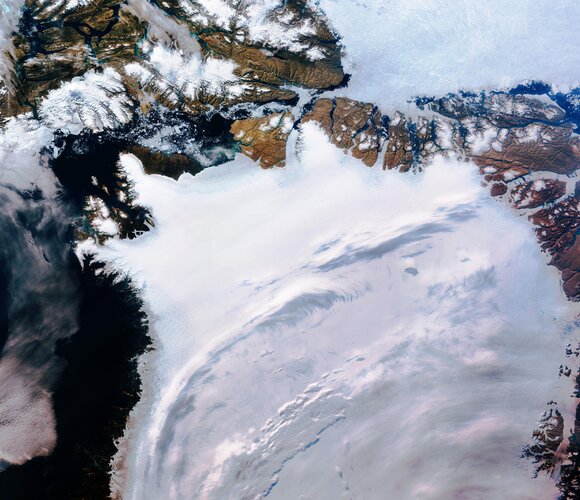 Image:
Northwest Greenland is featured in this icy image captured by the Copernicus Sentinel-3 mission.
Image:
Northwest Greenland is featured in this icy image captured by the Copernicus Sentinel-3 mission.
US Federal Aviation Administration (FAA) upgrades to highest level of OGC Membership
8.5.2020 2:10 GISCafe.com Webcasts-Webinars FAA upgrades to OGC’s highest level of membership to help drive standards and shape development priorities relevant to aviation7 May 2020: …
INSPIRE téma Parcely (CP)
8.5.2020 2:00 Cenia - Katalog metadat ČR - INSPIRE Data odpovídají směrnici INSPIRE pro téma katastrální parcely (CP). Vychází z katastrální mapy, která je závazným státním mapovým dílem velkého měřítka, obsahuje body polohového bodového pole, polohopis a popis a může mít formu digitální mapy, analogové mapy nebo digitalizované mapy. Data publikovaná v rámci INSPIRE obsahují pouze katastrální území (pro celou Českou Republiku) a parcely a jejich hranice z území, kde je digitální mapa (k 04. 05. 2020 je to 96,75% území České republiky, t.j. 76 307,40km2). Více katastrální zákon 344/1992 SB., katastrální vyhláška č.26/2007 Sb. v platném znění a INSPIRE Data Specification on Cadastral Parcels v 3.0.1. Data ve formátu GML 3.2.1 jsou validní proti schématu XML pro INSPIRE téma Parcely ve verzi 4.0 a proti schématu pro prostorová data ELF ve verzi 1.0.INSPIRE téma Rozšířené Parcely (CPX)
8.5.2020 2:00 Cenia - Katalog metadat ČR - INSPIRE Rozšíření má za cíl poskytovat katastrální mapu s obsahem podle vyhlášky ve vektorové podobě ve struktuře plně v souladu se strukturou danou směrnicí INSPIRE. Data rozšiřují směrnici INSPIRE pro téma katastrální parcely (CP) o věcná břemena, geodetické body, další prvky mapy, původní obloukovou geometrii a o parcely určené definičním bodem (ty pouze v oblastech s analogovou mapou). Vychází z katastrální mapy, která je závazným státním mapovým dílem velkého měřítka, obsahuje body polohového bodového pole, polohopis a popis a může mít formu digitální mapy, analogové mapy nebo digitalizované mapy. Publikovaná data obsahují katastrální území pro celou Českou Republiku, parcely a jejich hranice, věcná břemena, další prvky mapy a původní obloukovou geometrii z území, kde je digitální mapa (k 04. 05. 2020 je to 96,75% území České republiky, t.j. 76 307,40km2) a ve zbytku území katastrální parcely určené pouze definičním bodem (tedy bez hranic a polygonu). Katastrální parcely a hranice obsahují oproti datové sadě INSPIRE některé atributy navíc. Jedná se o typ hranice, způsob využití území, druh pozemku, vazbu na budovu a o mapové značky. Více katastrální zákon 344/1992 SB., katastrální vyhláška č.26/2007 Sb. v platném znění a INSPIRE Data Specification on Cadastral Parcels v 3.0.1. Data ve formátu GML 3.2.1 jsou validní proti schématu XML pro Rozšířené Parcely (CPX) ve verzi 4.0.Katastrální mapa v rastrové podobě poskytovaná v e-shopu
8.5.2020 2:00 Cenia - Katalog metadat ČR - INSPIRE Katastrální mapa v rastrové podobě je poskytována za úplatu a obsahuje analogovou mapu s kompletní kresbou. Analogová mapa pokrývá 3,01 % území České republiky, což je 2 377,45km2. Více katastrální vyhláška č.357/2013 Sb. v platném znění.INSPIRE téma Budovy (BU)
8.5.2020 2:00 Cenia - Katalog metadat ČR - INSPIRE Data odpovídají směrnici INSPIRE pro téma budovy (BU). Data pochází částečně z projektu RÚIAN (Registr územní identifikace, adres a nemovitostí), který je součástí základních registrů České Republiky a obsahuje informace o územní identifikaci, adresách a nemovitostech, a částečně z ISKN (Informační systém katastru nemovistostí). Zdrojem informací o budovách v ISKN je objekt Stavba, v RÚIAN je to Stavební objekt. Většina Staveb je zároveň Stavebními objekty, ale jsou případy, kdy tomu tak není. Kromě Budov datová sada obsahuje i části budov, které jsou pro potřeby INSPIRE vyjádřeny vchody z RÚIAN. Vchody obsahují informace o počtu podlaží, technickoekonomických atributech apod. Datová sada pokrývá celé území české republiky. V datové sadě není uvedeno 1,14%, t.j. 48348 budov (k 04. 05. 2020), protože neobsahují definiční bod ani polygon. Více v zákoně č. 111/2009 Sb., o základních registrech, ve vyhlášce č. 359/2011 Sb., o základním registru územní identifikace, adres a nemovitostí v platných zněních, v zákoně 256/2013 Sb., o katastru nemovitostí, v katastrální vyhlášce č. 357/2013 Sb. v platném znění a INSPIRE Data Specification on Buildings v 3.0 z 13.12.2013. Data ve formátu GML 3.2.1 jsou validní proti schématu XML pro INSPIRE téma Budovy ve verzi 4.0 a proti schématu pro prostorová data ELF ve verzi 1.0.Katastrální mapa ve formátech DGN a DXF poskytovaná v e-shopu
8.5.2020 2:00 Cenia - Katalog metadat ČR - INSPIRE Katastrální mapa je závazným státním mapovým dílem velkého měřítka, obsahuje body polohového bodového pole, polohopis a popis. Katastrální mapa ve vektorové podobě je poskytována zdarma ve formátu DGN a DXF a obsahuje prvky Digitální katastrální mapy (DKM) a Katastrální mapy digitalizované (KMD), tedy bodová pole, budovy, další prvky mapy, hranice parcel, katastrální hranice, parcely katastru nemovitostí, prvky orientační mapy a hranice věcného břemene. Z důvodu použití formátu DGN produkt neobsahuje značky na liniích a oblouky jsou nahrazeny lomenými čárami. Katastrální mapa ve vektorové podobě k 04. 05. 2020 pokrývá 96,75% území České republiky, t.j. 76 307,40km2. Více katastrální vyhláška č.357/2013 Sb. v platném znění.INSPIRE téma Adresy (AD)
8.5.2020 2:00 Cenia - Katalog metadat ČR - INSPIRE Data odpovídají směrnici INSPIRE pro téma adresy (AD). Vychází především z projektu RÚIAN (Registr územní identifikace, adres a nemovitostí), který je součástí základních registrů České Republiky a obsahuje informace o územní identifikaci, adresách a nemovitostech. Data publikovaná v rámci INSPIRE obsahují pouze adresní místa a jejich komponenty, kterými jsou stát, obec, část obce, městský obvod v Praze (MOP), městký obvod/městská část (MO/MČ), ulice a pošta a to na území celé České Republiky. Obsahují rozvněž geometrii, která určuje definiční bod adresního místa. V datové sadě nění uvedeno 1,17%, t.j. 34234 adresních míst (k 04. 05. 2020), protože neobsahují definiční bod, podle kterého by je bylo možné prostorově určit. Více v zákoně č. 111/2009 Sb., o základních registrech a ve vyhlášce č. 359/2011 Sb., o základním registru územní identifikace, adres a nemovitostí v platných zněních a INSPIRE Data Specification on Addresses v 3.0.1 z 26.4.2010. Data ve formátu GML 3.2.1 jsou validní proti schématu XML pro INSPIRE téma Adresy ve verzi 4.0 a proti schématu pro prostorová data ELF ve verzi 1.0.Kratos Reports First Quarter 2020 Financial Results
8.5.2020 1:10 GISCafe.com Webcasts-Webinars First Quarter 2020 Revenues of $168.9 Million Increase 5.3% over First Quarter 2019 Revenues First Quarter Bookings of $213.1 Million and a …Primoco UAV Model One 150 Shatters Endurance Record, Ensuring Safety With Sagetech Avionics' XPS
8.5.2020 1:10 GISCafe.com Webcasts-Webinars WHITE SALMON, Wash., May 7, 2020 — (PRNewswire) — Primoco UAV, a leading global manufacturer of unmanned aircraft, recently demonstrated …Dive Delivery Begins Backyard Drone Deliveries of Essential Goods in San Mateo & Contra Costa Counties (CA)
7.5.2020 18:32 GISCafe.com Webcasts-Webinars In an effort to get people familiar with the concept of drone-based deliveries, Dive Delivery has secured confirmation of permission from the FAA to …EU Space growing #strongertogether: Happy Europe Day
7.5.2020 16:57 European GNSS Agency
As the European Union celebrates Europe Day on May 9, we take a look at how the EU space programmes, themselves a result of European cooperation, are helping the European Union achieve concrete goals of a more united and prosperous Europe.
Europe Day 2020 marks the 70th anniversary of the signing of the Schuman Declaration in 1950, which laid out a blueprint for the creation of a new era of peace and prosperity in Europe. The European Union that grew out of this Declaration has among its key goals to promote scientific and technological progress and enhance economic, social and territorial cohesion in Europe. Space is playing a key role in reaching these goals.
By working at European level to deliver benefits to all Europeans, the Galileo programme embodies the EU spirit. Made possible by cooperation between the EU Member States, it is civilian in nature – its core aim is to benefit EU citizens - and free of charge. It is also 100% European and guarantees EU independence in satellite navigation.
Space at the forefront
Galileo, along with the other components of the European Space Programme EGNOS and Copernicus, is at the forefront of scientific and technological innovation in Europe. These programmes are making a core contribution to growth in the European economy, through job and revenue creation and the provision of services that have a positive impact on people’s lives. In total, the space programmes account for the creation of an estimated 250,000 jobs in Europe.
Read this: Galileo Green Lane, easing pressure at the EU’s internal borders
Satellites and the location-based and Earth-observation services that they enable, are transforming the way we live and work. Space technology is driving innovation in almost all sectors of the European economy. From agriculture and transport to healthcare, space technology is underpinning technological progress. A current example, with consequences for transport, healthcare and the economy as a whole, is the “Galileo Green Lane” app.
Developed by the European GNSS Agency (GSA), in collaboration with the European Commission, the “Galileo Green Lane” mobile solution is part of the EU response to the COVID-19 pandemic. The app uses Galileo positioning to facilitate the free movement of freight, reduce waiting times at the EU’s internal land borders and prioritise the transport of essential goods. In so doing, it supports a fundamental principle of the EU internal market - the free movements of goods and freight.
Solutions for citizens
Galileo Green Lane is one of a range of space-based solutions that are being used to fight the COVID-19 pandemic. The GSA is compiling a repository of these solutions emergency response services, citizens and app developers to understand current needs and available resources.
And this: Looking to space for solutions on Earth Day
In other areas too, the European space programmes are at the cutting-edge of innovation. In autonomous transport Galileo is supporting the development of new solutions, such as the ESCAPE GNSS engine (EGE), which was successfully tested in France at the end of last year, bringing autonomous driving one step closer.
From Galileo-enabled Search and Rescue and eCall, which are helping to save lives, to EGNOS-enabled precision farming, which is reducing the environmental footprint of the European agricultural sector, space is helping to make Europe safer, cleaner, and more prosperous. Earth observation is also a key tool in the EU’s efforts towards a better Europe, supporting environmental and climate objectives, for example, and helping to maintain the security of the EU’s external borders.
Watch this: Happy Europe Day
As stated in the Schuman Declaration: “Europe will be built through concrete achievements which first create a de facto solidarity.” So, on Europe Day, the GSA joins with all Europeans in celebrating European unity. The Agency, with its 200 staff from 21 different countries, remains committed to its core principle of leveraging space to meet the needs of European citizens, both during the current crisis and into the future.
Media note: This feature can be republished without charge provided the European GNSS Agency (GSA) is acknowledged as the source at the top or the bottom of the story. You must request permission before you use any of the photographs on the site. If you republish, we would be grateful if you could link back to the GSA website (http://www.gsa.europa.eu).
Velodyne Lidar Announces Multi-Year Sales Agreement With GeoSLAM
7.5.2020 16:47 GISCafe.com Webcasts-Webinars Velodyne Lidar Sensors Power GeoSLAM’s Data Capture SolutionsSAN JOSE, Calif. — (BUSINESS WIRE) — May 7, 2020 —
Velodyne Lidar, …
FLIR Wins $20.6 Million Contract to Provide Black Hornet Nano-UAV Systems for U.S. Army’s Soldier Borne Sensor Program
7.5.2020 16:47 GISCafe.com Webcasts-Webinars Award Augments Army’s $40 Million Initial Order for Black Hornets in Early 2019ARLINGTON, Va. — (BUSINESS WIRE) — May 7, 2020 …
Esri Offers Free Access to GIS Training for Furloughed Professionals Affected by Coronavirus
7.5.2020 16:47 GISCafe.com Webcasts-Webinars Complimentary Software and Lessons Support Learning during COVID-19 OutbreakREDLANDS, Calif. — (BUSINESS WIRE) — May 7, 2020 …
Esri Provides Free COVID-19 Resources to Nonprofits
7.5.2020 16:47 GISCafe.com Webcasts-Webinars Global Communities Can Access Advanced Mapping Technology during PandemicREDLANDS, Calif. — (BUSINESS WIRE) — May 7, 2020 —
Esri, …
DJI Defines a New Standard for Industrial Tools by Unveiling the Most Advanced Commercial Drone Platform and its First Hybrid Camera Series
7.5.2020 16:47 GISCafe.com Webcasts-Webinars New Matrice 300 RTK and Zenmuse H20 Series Extend Airborne Intelligence to a New Generation of Work Ready to Embrace Digitalisation and AISHENZHEN, …
Přerušení provozu DP a WSDP ve čtvrtek 14.5.2020 od 20:00 až do cca 22:00.
7.5.2020 13:49 Dálkový přístup k údajům KN ČR Vážení uživatelé,oznamujeme, že ve čtvrtek 14.5.2020 od 20:00 bude z provozních důvodů zcela přerušen provoz Dálkového přístupu i Webových služeb dálkového přístupu. Obnovení provozu předpokládáme v cca 22 hodin.
Za komplikace tímto způsobené se omlouváme a děkujeme za pochopení.
Přerušení provozu DP a WSDP ve čtvrtek 14.5.2020 od 20:00 až do cca 22:00.
7.5.2020 13:49 ČÚZK - předpisy a opatření Vážení uživatelé,oznamujeme, že ve čtvrtek 14.5.2020 od 20:00 bude z provozních důvodů zcela přerušen provoz Dálkového přístupu i Webových služeb dálkového přístupu. Obnovení provozu předpokládáme v cca 22 hodin.
Za komplikace tímto způsobené se omlouváme a děkujeme za pochopení.
Přerušení provozu DP a WSDP ve čtvrtek 14.5.2020 od 20:00 až do cca 22:00.
7.5.2020 13:49 ČÚZK /Aplikace-DP-do-KN/Aplikace-DP-do-KN/Archiv-DP/288867Upozornění pro návštěvníky KP Benešov
7.5.2020 13:39 ČÚZK - předpisy a opatření Český úřad zeměměřický a katastrální zveřejnil novou aktualitu: V části "Úřední deska", v sekci "Další základní údaje, informace " bylo vystaveno "Upozornění pro návštěvníky KP Benešov"Upozornění pro návštěvníky KP Benešov
7.5.2020 13:39 ČÚZK - předpisy a opatření Katastrální úřad pro Středočeský kraj - Katastrální pracoviště Benešov zveřejnil novou aktualitu: V části "Úřední deska", v sekci "Další základní údaje, informace " bylo vystaveno "Upozornění pro návštěvníky KP Benešov"Upozornění pro návštěvníky KP Benešov
7.5.2020 13:39 ČÚZK /Urady/Katastralni-urady/Katastralni-urady/Katastralni-urad-pro-Stredocesky-kraj/Katastralni-pracoviste/KP-Benesov/O-uradu/Aktuality/Upozorneni-pro-navstevniky-KP-BenesovProximity Tracing Toolbox
7.5.2020 11:41 ARCDATAPokud pomocí geodat sledujete pohyb osob či vozidel, můžete použít nový nástroj Proximity Tool pro analýzu zda, kde a na jak dlouho se k sobě přiblížily. Využití se nabízí nejen v této době, kdy se vzájemné kontakty řeší v souvislosti s nákazou COVID-19, ale i při analýze a optimalizaci činnosti pracovních čet, analýze pohybu zvířat a při dalších úlohách.
Nástroj pracuje v ArcGIS Pro 2.5 a lze jej spustit i na GeoAnalytics Serveru ArcGIS Enterprise.
Podrobnosti o nástroji a jeho použití naleznete v článku na blogu Esri Use Proximity Tracing to Identify Possible Contact Events.

Nedostupnost WSDP na zkoušku od pondělka 11.5.2020
7.5.2020 9:45 ČÚZK /Aplikace-DP-do-KN/Aplikace-DP-do-KN/Archiv-DP/288822Nedostupnost WSDP na zkoušku od pondělka 11.5.2020
7.5.2020 9:45 ČÚZK - předpisy a opatření Vážení uživatelé webových služeb,oznamujeme, že od pondělka 11.5.2020 nebudou z provozních důvodů dostupné webové služby na zkoušku. Obnovení provozu předpokládáme 15.5.2020.
Za komplikace tímto způsobené se omlouváme a děkujeme za pochopení.
Nedostupnost WSDP na zkoušku od pondělka 11.5.2020
7.5.2020 9:45 Dálkový přístup k údajům KN ČR Vážení uživatelé webových služeb,oznamujeme, že od pondělka 11.5.2020 nebudou z provozních důvodů dostupné webové služby na zkoušku. Obnovení provozu předpokládáme 15.5.2020.
Za komplikace tímto způsobené se omlouváme a děkujeme za pochopení.
Zveřejnění obsahu informací poskytnutých na žádost dle zákona č. 106/1999 Sb. za rok 20
7.5.2020 9:06 ČÚZK /Urady/Katastralni-urady/Katastralni-urady/Katastralni-urad-pro-Plzensky-kraj/Casto-hledane-informace/Poskytovani-informaci-106-1999-Sb/Zverejneni-obsahu-informaci-poskytnutych-na-za-(1)/Zverejneni-obsahu-informaci-poskytnutych-na-za-(2)Zveřejnění obsahu informací poskytnutých na žádost dle zákona č. 106/1999 Sb. za rok 20
7.5.2020 9:06 ČÚZK - předpisy a opatření Katastrální úřad pro Plzeňský krajzveřejňuje obsah informace poskytnutých na žádost dle zákona č. 106/1999 Sb. za rok
2020
Zveřejnění obsahu informací poskytnutých na žádost dle zákona č. 106/1999 Sb. za rok 20
7.5.2020 9:05 ČÚZK - předpisy a opatření Katastrální úřad pro Plzeňský krajzveřejňuje obsah informace poskytnutých na žádost dle zákona č. 106/1999 Sb. za rok
2019
Zveřejnění obsahu informací poskytnutých na žádost dle zákona č. 106/1999 Sb. za rok 20
7.5.2020 9:05 ČÚZK /Urady/Katastralni-urady/Katastralni-urady/Katastralni-urad-pro-Plzensky-kraj/Casto-hledane-informace/Poskytovani-informaci-106-1999-Sb/Zverejneni-obsahu-informaci-poskytnutych-na-za-(1)/Zverejneni-obsahu-informaci-poskytnutych-na-za-(1)Omezení otevírací doby 2020-05-07
7.5.2020 8:42 ČÚZK /Urady/Katastralni-urady/Katastralni-urady/Katastralni-urad-pro-Kralovehradecky-kraj/Katastralni-pracoviste/KP-Jicin/O-uradu/Aktuality/Omezeni-oteviraci-doby-2020-05-07Omezení otevírací doby 2020-05-07
7.5.2020 8:42 ČÚZK - předpisy a opatření Katastrální úřad pro Královéhradecký kraj - Katastrální pracoviště Jičínzveřejnil novou aktualitu: Čtvrtek 7.5.2020 je budova soudu z technických důvodů otevřena pouze do 11.00 hod. Úřední hodiny zde sídlících organizací tedy končí také v 11.00 hod.
Trimble Reports First Quarter 2020 Results
7.5.2020 1:21 GISCafe.com Webcasts-Webinars - Earnings per share exceed guidanceSUNNYVALE, Calif., May 6, 2020 — (PRNewswire) — Trimble Inc. (NASDAQ: TRMB) today announced …
Thales to Establish Digital Competence Centre in Qatar Free Zones to Support Security of Sports Facilities, Counter-UAV and Other Large-Scale Projects
7.5.2020 1:21 GISCafe.com Webcasts-Webinars The Centre will include an incubator to support the development of systems in the areas of security and defense and digital identityDOHA, Qatar …
Qinertia, SBG Systems’ PPK software now supports third-party IMUs and offers a GNSS post-processing license covering all major GNSS receivers
6.5.2020 22:55 GISCafe.com Webcasts-Webinars Carrières-sur-Seine, France, May 4th 2020 - SBG Systems’ popular INS/GNSS PPK software called Qinertia now covers all surveyors’ …New insurtech product, Milliman PinPoint, selected by North Carolina Rate Bureau to deliver granular flood rating plan
6.5.2020 21:47 GISCafe.com Webcasts-Webinars Milliman PinPoint offers location-level geospatial data and premium calculations customized for unique rating plans and underwriting rules in both …Panzura Launches Mobile™ 3.5 for Remote Enterprise Workers
6.5.2020 17:55 GISCafe.com Webcasts-Webinars Delivers unprecedented scale for large enterprises, advanced security and IP protection, and Real-Time Access to Panzura's Global Cloud File System …ESA–EGU award for Earth observation excellence
6.5.2020 17:30 ESA Observing the Earth
Like all gatherings during these times of COVID-19 isolation, the European Geosciences Union’s annual General Assembly is different this year with thousands of Earth, planetary and space scientists taking part virtually to discuss their research and latest findings. So, with eyes still very much on science this week, ESA’s Director of Earth Observation Programmes, Josef Aschbacher announced the launch of a new award for excellence in Earth observation during his online presentation.
ESA–EGU award for Earth observation excellence
6.5.2020 17:30 ESA Observing the Earth
Like all gatherings during these times of COVID-19 isolation, the European Geosciences Union’s annual General Assembly is different this year with thousands of Earth, planetary and space scientists taking part virtually to discuss their research and latest findings. So, with eyes still very much on science this week, ESA’s Director of Earth Observation Programmes, Josef Aschbacher announced the launch of a new award for excellence in Earth observation during his online presentation.
Draganfly Completes Sale of its Sauce Video Technology Asset to Oracle
6.5.2020 16:17 GISCafe.com Webcasts-Webinars Los Angeles, CA, May 06, 2020 (GLOBE NEWSWIRE) -- Draganfly Inc. (CSE: DFLY) (OTCQB: DFLYF) (FSE: 3U8) (“Draganfly” or the “Company”), an …Shedding light on the ocean’s living carbon pump
6.5.2020 12:45 ESA Observing the Earth
Phytoplankton play a crucial role in ocean biology and climate. Understanding the natural processes that influence phytoplankton primary production, and how they are changing as the planet warms, is vital. A new study, using data from the European Space Agency’s Climate Change Initiative, has produced a 20-year time-series of global primary production in the oceans – shedding new light on the ocean’s living carbon pump.
OGC seeks public comment on Version 1.3 of GeoPackage Standard
6.5.2020 11:36 GISCafe.com Webcasts-Webinars 5 May 2020: The Open Geospatial Consortium (OGC) seeks public comment on the latest version of the GeoPackage Standard, v1.3.0. GeoPackage is an …Interview with Matt Cicchinelli, President of PAR Government Systems Corp
6.5.2020 9:00 GISCafe.com Webcasts-WebinarsVolná místa - 2020-05-06
6.5.2020 8:07 ČÚZK /Urady/Katastralni-urady/Katastralni-urady/Katastralni-urad-pro-hlavni-mesto-Prahu/O-uradu/Aktuality/Volna-mista-2020-05-06Volná místa - 2020-05-06
6.5.2020 8:07 ČÚZK - předpisy a opatření Katastrální úřad pro hlavní město Prahu - Katastrální pracoviště Praha zveřejnil novou aktualitu: Volná místa:* rada/odborný rada - právník
* referent/vrchní referent – poskytování informací, nahlížení do KN
* rada/odborný rada – kontrola listin určených k záznamu
Podrobnosti zde
odborný referent/vrchní referent – poskytování informací, nahlížení do KN
6.5.2020 8:02 ČÚZK - volná místa Katastrální úřad pro hlavní město Prahu Katastrální pracoviště Praha vypisuje výběrové řízení na místo odborný referent/vrchní referent – poskytování informací, nahlížení do KNodborný referent/vrchní referent – poskytování informací, nahlížení do KN
6.5.2020 8:02 ČÚZK - předpisy a opatření Katastrální úřad pro hlavní město Prahu - Katastrální pracoviště Prahavypisuje výběrové řízení na místo
odborný referent/vrchní referent – poskytování informací, nahlížení do KN