


![]()

zprávy
zdroje zpráv:Dejte svůj hlas v soutěži pozemkových úprav. Žít krajinou 2019
1.2.2020 0:10 ZeměměřičOd 1. do 29. února 2020 může veřejnost svým hlasem podpořit některý z třiceti pěti přihlášených projektů v letošním třináctém ročníku soutěže Žít krajinou. Státní pozemkový úřad (SPÚ) ve spolupráci se Stálou komisí senátu pro rozvoj venkova a s Českomoravskou komorou pro pozemkové úpravy hledá pomocí soutěže nejkvalitnější realizovaná tzv. společná zařízení, navrhovaná v pozemkových úpravách. Jednou z udělovaných cen je Cena veřejnosti. O […]
The post Dejte svůj hlas v soutěži pozemkových úprav. Žít krajinou 2019 appeared first on Zeměměřič.
URISA's GIS Hall of Fame Award Nominations Invited
31.1.2020 19:53 GISCafe.com Webcasts-Webinars Des Plaines, IL (January 31, 2020) URISA's GIS Hall of Fame honors persons and organizations that have made significant and original …Galileo performance assessment
31.1.2020 15:16 European GNSS Agency
The Galileo performance is reported in the Galileo Initial Services – Open Service – Quarterly Performance Report, where several key performance indicators are analysed according to criteria (Minimum Performance Levels, MPLs) defined in the Galileo Service Definition document (SDD), published in the European GNSS Service Centre and last updated in May 2019.
As planned, recently the GSA published the Q3 2019 performance report. This report covers the period when a technical incident caused by an equipment malfunction in Galileo last July resulted in a six-day interruption in Galileo navigation and timing services. This had an important effect on the programme and, following the incident, an independent Inquiry Board was set up by the European Commission to investigate its causes and to make recommendations for actions to avoid another such incident in the future.
Performance measurement: how is it done?
Measurement of service performance is one of the key activities of the GSA, the Galileo Service Provider. The GSA’s Galileo Reference Centre, located in Noordwijk, the Netherlands, plays a crucial role in monitoring the Galileo performance .
The Galileo Reference Centre (GRC) is one of the Galileo Service Facilities and it supports the provision of services to Galileo users. The GRC is operated by the GSA, providing an independent means of evaluating the performance of the Galileo Service Operator and the quality of the signals in space. The GRC is fully independent of the system and the Galileo Service Operator with respect to both the technical solution and operations, and consists of both a core facility and contributions available in EU Member States, Norway and Switzerland. Data and products from cooperating entities in the Member States make it possible to observe the Galileo signals all over the world at all times, in support of both routine operations and specific performance assessment campaigns.
The minimum performance levels
The MPLs address several parameters of interest, and can be mainly grouped into two categories:
- Accuracy MPLs refer to how well (accurately) the Galileo services perform, whenever the Galileo signals are usable (or “healthy”, as defined in the SDD). This includes:
- Ranging Accuracy; related to the navigation data transmitted by the satellites which is used to calculate the distance between the satellite and the receiver;
- Timing and Frequency Accuracy; related to the parameters that allow the receiver to obtain a precise synchronisation to either Universal Time Coordinated (UTC) or GPS time.
Accuracy MPLs are statistically defined as “95th percentile”, and calculated over a period of 30 days, using a sample of measurements taken every 5 minutes and considering only those epochs where the signals were healthy. In line with other GNSS constellation providers, timing parameters are normalised over a year by averaging the past twelve 30-day periods. For accuracy parameters, the smaller the achieved value, the better.
- Availability MPLs refer to how much time per month (or year) a given performance level is to be met (for which the signals have to be healthy). This includes:
- Per-Slot Availability; related to the amount of time per period that the signals from each satellite are healthy;
- Timing Availability; related to the amount of time per period that the timing parameters are broadcast, and the time synchronisation error is within the specified target;
- Positioning Availability; related to the amount of time per period that the users have enough satellites in view to calculate their position, and the calculated position error is within the specified target.
Availability MPLs are reported as percent, and calculated over a period of 30 days, using a sample of measurements taken every 5 minutes and considering all epochs (healthy or not). Again, in line with other GNSS constellation providers, some parameters are normalised over a year by averaging the past twelve 30-day periods (timing and per-slot availability). For availability parameters, the larger the achieved value, the better.
The Service Definition Document also describes how to assess whether the Galileo signals are healthy or not, by looking into some parameters (“flags”) transmitted by the satellites, and checking the last time when the navigation data was refreshed (it should not be older than 4 hours).
The Galileo performance in Q3 2019
The Galileo system is currently in a partial deployment stage, with some satellites still to be launched and a number of ground infrastructure upgrades on-going to provide redundancy and complete all functionalities. For this reason, the MPL commitments published in the SDD include margins that account for possible planned and unplanned outages. The quarterly performance reports provide visibility on the measured performance and compare it with the MPL. Galileo has regularly performed well above the MPL targets since the declaration of Initial Services in 2016.
The Galileo incident in July 2019 prevented the refresh of the data transmitted by the satellites, therefore eventually the signals were flagged a not healthy and/or the data became outdated. This caused an impact on the availability MPLs that are calculated monthly. These parameters went well below the values typically provided by Galileo, yet in most of the cases (all but two) they stayed above the committed figure, which includes margins for the reasons explained above. The performance report, therefore, displays them as “green” in the dashboard, however the trend chart clearly shows the difference with the months of June and August and the margin with the MPL.
An example is provided below (Figure 12 of the Quarterly Performance Report Q3 2019, page 19) for the positioning availability:

The committed value (MPL) is 77%. Due to the incident in July, the signals were not available for some days and the parameter was only met 81% of the time, whereas in August and September it was met well above 99%. Still, all values are above the target.
Another example (Figure 16 of the Quarterly Performance Report Q3 2019, page 13) for the time determination availability:

In this case, the committed value (MPL) is 87%. Due to the incident in July, the parameter was only met 81% of the time therefore not fulfilling the target, whereas in August and September it was met 100%.
During the 3rd quarter of 2019, whenever the signals were Healthy, they provided good performance. Therefore, the accuracy MPLs were fulfilled despite the incident.
An example is provided below (Figure 2 of the Quarterly Performance Report Q3 2019, page 10) for the ranging accuracy:

The committed value (MPL) is 7 meters, 95%. During July, August and September, 95% of the time where the signals were healthy the error was below 0.5 meters for all satellites. Therefore, the target was largely met.
Next steps
Regardless of the fact that the published MPLs were mostly met due to a proper estimation of the margins associated to the current deployment status, the programme fully recognises the magnitude of the service outage, and is working consistently on actions to increase Galileo’s stability, robustness and resilience. This will translate into a future update of the Service Definition Document, including more stringent commitments with lower margins, and the reporting of the delivered performance according to the new MPLs.
Media note: This feature can be republished without charge provided the European GNSS Agency (GSA) is acknowledged as the source at the top or the bottom of the story. You must request permission before you use any of the photographs on the site. If you republish, we would be grateful if you could link back to the GSA website (http://www.gsa.europa.eu).
Galileo performance assessment
31.1.2020 15:16 European GNSS AgencyThe Galileo performance is reported in the Galileo Initial Services – Open Service – Quarterly Performance Report, where several key performance indicators are analysed according to criteria (Minimum Performance Levels, MPLs) defined in the Galileo Service Definition document (SDD), published in the European GNSS Service Centre and last updated in May 2019.
As planned, recently the GSA published the Q3 2019 performance report. This report covers the period when a technical incident caused by an equipment malfunction in Galileo last July resulted in a six-day interruption in Galileo navigation and timing services. This had an important effect on the programme and, following the incident, an independent Inquiry Board was set up by the European Commission to investigate its causes and to make recommendations for actions to avoid another such incident in the future.
Performance measurement: how is it done?
Measurement of service performance is one of the key activities of the GSA, the Galileo Service Provider. The GSA’s Galileo Reference Centre, located in Noordwijk, the Netherlands, plays a crucial role in monitoring the Galileo performance .
The Galileo Reference Centre (GRC) is one of the Galileo Service Facilities and it supports the provision of services to Galileo users. The GRC is operated by the GSA, providing an independent means of evaluating the performance of the Galileo Service Operator and the quality of the signals in space. The GRC is fully independent of the system and the Galileo Service Operator with respect to both the technical solution and operations, and consists of both a core facility and contributions available in EU Member States, Norway and Switzerland. Data and products from cooperating entities in the Member States make it possible to observe the Galileo signals all over the world at all times, in support of both routine operations and specific performance assessment campaigns.
The minimum performance levels
The MPLs address several parameters of interest, and can be mainly grouped into two categories:
- Accuracy MPLs refer to how well (accurately) the Galileo services perform, whenever the Galileo signals are usable (or “healthy”, as defined in the SDD). This includes:
- Ranging Accuracy; related to the navigation data transmitted by the satellites which is used to calculate the distance between the satellite and the receiver;
- Timing and Frequency Accuracy; related to the parameters that allow the receiver to obtain a precise synchronisation to either Universal Time Coordinated (UTC) or GPS time.
Accuracy MPLs are statistically defined as “95th percentile”, and calculated over a period of 30 days, using a sample of measurements taken every 5 minutes and considering only those epochs where the signals were healthy. In line with other GNSS constellation providers, timing parameters are normalised over a year by averaging the past twelve 30-day periods. For accuracy parameters, the smaller the achieved value, the better.
- Availability MPLs refer to how much time per month (or year) a given performance level is to be met (for which the signals have to be healthy). This includes:
- Per-Slot Availability; related to the amount of time per period that the signals from each satellite are healthy;
- Timing Availability; related to the amount of time per period that the timing parameters are broadcast, and the time synchronisation error is within the specified target;
- Positioning Availability; related to the amount of time per period that the users have enough satellites in view to calculate their position, and the calculated position error is within the specified target.
Availability MPLs are reported as percent, and calculated over a period of 30 days, using a sample of measurements taken every 5 minutes and considering all epochs (healthy or not). Again, in line with other GNSS constellation providers, some parameters are normalised over a year by averaging the past twelve 30-day periods (timing and per-slot availability). For availability parameters, the larger the achieved value, the better.
The Service Definition Document also describes how to assess whether the Galileo signals are healthy or not, by looking into some parameters (“flags”) transmitted by the satellites, and checking the last time when the navigation data was refreshed (it should not be older than 4 hours).
The Galileo performance in Q3 2019
The Galileo system is currently in a partial deployment stage, with some satellites still to be launched and a number of ground infrastructure upgrades on-going to provide redundancy and complete all functionalities. For this reason, the MPL commitments published in the SDD include margins that account for possible planned and unplanned outages. The quarterly performance reports provide visibility on the measured performance and compare it with the MPL. Galileo has regularly performed well above the MPL targets since the declaration of Initial Services in 2016.
The Galileo incident in July 2019 prevented the refresh of the data transmitted by the satellites, therefore eventually the signals were flagged as not healthy and/or the data became outdated. This caused an impact on the availability MPLs that are calculated monthly. These parameters went well below the values typically provided by Galileo, yet in most of the cases (all but two) they stayed above the committed figure, which includes margins for the reasons explained above. The performance report, therefore, displays them as “green” in the dashboard, however the trend chart clearly shows the difference with the months of June and August and the margin with the MPL.
An example is provided below (Figure 12 of the Quarterly Performance Report Q3 2019, page 19) for the positioning availability:
The committed value (MPL) is 77%. Due to the incident in July, the signals were not available for some days and the parameter was only met 81% of the time, whereas in August and September it was met well above 99%. Still, all values are above the target.
Another example (Figure 16 of the Quarterly Performance Report Q3 2019, page 13) for the time determination availability:
In this case, the committed value (MPL) is 87%. Due to the incident in July, the parameter was only met 81% of the time therefore not fulfilling the target, whereas in August and September it was met 100%.
During the 3rd quarter of 2019, whenever the signals were Healthy, they provided good performance. Therefore, the accuracy MPLs were fulfilled despite the incident.
An example is provided below (Figure 2 of the Quarterly Performance Report Q3 2019, page 10) for the ranging accuracy:
The committed value (MPL) is 7 meters, 95%. During July, August and September, 95% of the time where the signals were healthy the error was below 0.5 meters for all satellites. Therefore, the target was largely met.
Next steps
Regardless of the fact that the published MPLs were mostly met due to a proper estimation of the margins associated to the current deployment status, the programme fully recognises the magnitude of the service outage, and is working consistently on actions to increase Galileo’s stability, robustness and resilience. This will translate into a future update of the Service Definition Document, including more stringent commitments with lower margins, and the reporting of the delivered performance according to the new MPLs.
Media note: This feature can be republished without charge provided the European GNSS Agency (GSA) is acknowledged as the source at the top or the bottom of the story. You must request permission before you use any of the photographs on the site. If you republish, we would be grateful if you could link back to the GSA website (http://www.gsa.europa.eu).
Galileo performance assessment
31.1.2020 15:16 European GNSS AgencyThe Galileo performance is reported in the Galileo Initial Services – Open Service – Quarterly Performance Report, where several key performance indicators are analysed according to criteria (Minimum Performance Levels, MPLs) defined in the Galileo Service Definition document (SDD), published in the European GNSS Service Centre and last updated in May 2019.
As planned, recently the GSA published the Q3 2019 performance report. This report covers the period when a technical incident caused by an equipment malfunction in Galileo last July resulted in a six-day interruption in Galileo navigation and timing services. This had an important effect on the programme and, following the incident, an independent Inquiry Board was set up by the European Commission to investigate its causes and to make recommendations for actions to avoid another such incident in the future.
Performance measurement: how is it done?
Measurement of service performance is one of the key activities of the GSA, the Galileo Service Provider. The GSA’s Galileo Reference Centre, located in Noordwijk, the Netherlands, plays a crucial role in monitoring the Galileo performance .
The Galileo Reference Centre (GRC) is one of the Galileo Service Facilities and it supports the provision of services to Galileo users. The GRC is operated by the GSA, providing an independent means of evaluating the performance of the Galileo Service Operator and the quality of the signals in space. The GRC is fully independent of the system and the Galileo Service Operator with respect to both the technical solution and operations, and consists of both a core facility and contributions available in EU Member States, Norway and Switzerland. Data and products from cooperating entities in the Member States make it possible to observe the Galileo signals all over the world at all times, in support of both routine operations and specific performance assessment campaigns.
The minimum performance levels
The MPLs address several parameters of interest, and can be mainly grouped into two categories:
- Accuracy MPLs refer to how well (accurately) the Galileo services perform, whenever the Galileo signals are usable (or “healthy”, as defined in the SDD). This includes:
- Ranging Accuracy; related to the navigation data transmitted by the satellites which is used to calculate the distance between the satellite and the receiver;
- Timing and Frequency Accuracy; related to the parameters that allow the receiver to obtain a precise synchronisation to either Universal Time Coordinated (UTC) or GPS time.
Accuracy MPLs are statistically defined as “95th percentile”, and calculated over a period of 30 days, using a sample of measurements taken every 5 minutes and considering only those epochs where the signals were healthy. In line with other GNSS constellation providers, timing parameters are normalised over a year by averaging the past twelve 30-day periods. For accuracy parameters, the smaller the achieved value, the better.
- Availability MPLs refer to how much time per month (or year) a given performance level is to be met (for which the signals have to be healthy). This includes:
- Per-Slot Availability; related to the amount of time per period that the signals from each satellite are healthy;
- Timing Availability; related to the amount of time per period that the timing parameters are broadcast, and the time synchronisation error is within the specified target;
- Positioning Availability; related to the amount of time per period that the users have enough satellites in view to calculate their position, and the calculated position error is within the specified target.
Availability MPLs are reported as percent, and calculated over a period of 30 days, using a sample of measurements taken every 5 minutes and considering all epochs (healthy or not). Again, in line with other GNSS constellation providers, some parameters are normalised over a year by averaging the past twelve 30-day periods (timing and per-slot availability). For availability parameters, the larger the achieved value, the better.
The Service Definition Document also describes how to assess whether the Galileo signals are healthy or not, by looking into some parameters (“flags”) transmitted by the satellites, and checking the last time when the navigation data was refreshed (it should not be older than 4 hours).
The Galileo performance in Q3 2019
The Galileo system is currently in a partial deployment stage, with some satellites still to be launched and a number of ground infrastructure upgrades on-going to provide redundancy and complete all functionalities. For this reason, the MPL commitments published in the SDD include margins that account for possible planned and unplanned outages. The quarterly performance reports provide visibility on the measured performance and compare it with the MPL. Galileo has regularly performed well above the MPL targets since the declaration of Initial Services in 2016.
The Galileo incident in July 2019 prevented the refresh of the data transmitted by the satellites, therefore eventually the signals were flagged a not healthy and/or the data became outdated. This caused an impact on the availability MPLs that are calculated monthly. These parameters went well below the values typically provided by Galileo, yet in most of the cases (all but two) they stayed above the committed figure, which includes margins for the reasons explained above. The performance report, therefore, displays them as “green” in the dashboard, however the trend chart clearly shows the difference with the months of June and August and the margin with the MPL.
An example is provided below (Figure 12 of the Quarterly Performance Report Q3 2019, page 19) for the positioning availability:

The committed value (MPL) is 77%. Due to the incident in July, the signals were not available for some days and the parameter was only met 81% of the time, whereas in August and September it was met well above 99%. Still, all values are above the target.
Another example (Figure 16 of the Quarterly Performance Report Q3 2019, page 13) for the time determination availability:

In this case, the committed value (MPL) is 87%. Due to the incident in July, the parameter was only met 81% of the time therefore not fulfilling the target, whereas in August and September it was met 100%.
During the 3rd quarter of 2019, whenever the signals were Healthy, they provided good performance. Therefore, the accuracy MPLs were fulfilled despite the incident.
An example is provided below (Figure 2 of the Quarterly Performance Report Q3 2019, page 10) for the ranging accuracy:

The committed value (MPL) is 7 meters, 95%. During July, August and September, 95% of the time where the signals were healthy the error was below 0.5 meters for all satellites. Therefore, the target was largely met.
Next steps
Regardless of the fact that the published MPLs were mostly met due to a proper estimation of the margins associated to the current deployment status, the programme fully recognises the magnitude of the service outage, and is working consistently on actions to increase Galileo’s stability, robustness and resilience. This will translate into a future update of the Service Definition Document, including more stringent commitments with lower margins, and the reporting of the delivered performance according to the new MPLs.
Media note: This feature can be republished without charge provided the European GNSS Agency (GSA) is acknowledged as the source at the top or the bottom of the story. You must request permission before you use any of the photographs on the site. If you republish, we would be grateful if you could link back to the GSA website (http://www.gsa.europa.eu).
rada/odborný rada - právník
31.1.2020 13:01 ČÚZK /Urady/Katastralni-urady/Katastralni-urady/Katastralni-urad-pro-hlavni-mesto-Prahu/Uredni-deska/Oznameni-a-jina-uredni-sdeleni/Volna-mista/DMS/rada-odborny-rada-pravnik-(1)rada/odborný rada - právník
31.1.2020 13:01 ČÚZK - volná místa Katastrální úřad pro hlavní město Prahu - Katastrální pracoviště Praha vypisuje výběrové řízení na místo rada/odborný rada - právníkrada/odborný rada - právník
31.1.2020 13:01 ČÚZK - volná místa Katastrální úřad pro hlavní město Prahu Katastrální pracoviště Praha vypisuje výběrové řízení na místo rada/odborný rada - právníkrada/odborný rada - právník
31.1.2020 13:01 ČÚZK - předpisy a opatření Katastrální úřad pro hlavní město Prahu - Katastrální pracoviště Prahavypisuje výběrové řízení na místo
rada/odborný rada - právník
Aktualizace verze TopoL xT 10.0
31.1.2020 12:00 Topol Software Je připravena nová aktualizace verze TopoL xT 10.0.27, která je ke stažení na našich stránkách."GISCafe Industry Predictions 2020 – Part 5" by Susan Smith
31.1.2020 11:56 GISCafe.com Webcasts-WebinarsPříspěvkové organizace
31.1.2020 11:40 Středočeský kraj Mapová aplikace Příspěvkové organizace byla aktualizována. Data jsou aktuální k 30.01.2020.Rada /odborný rada v oddělení právním č.1 na Katastrálním pracovišti Brno-město
31.1.2020 10:46 ČÚZK - předpisy a opatření Katastrální úřad pro Jihomoravský kraj Katastrální pracoviště Brno-městovypisuje výběrové řízení na místo
Rada /odborný rada v oddělení právním č.1 na Katastrálním pracovišti Brno-město
Rada /odborný rada v oddělení právním č.1 na Katastrálním pracovišti Brno-město
31.1.2020 10:46 ČÚZK - volná místa Katastrální úřad pro Jihomoravský kraj Katastrální pracoviště Brno-město vypisuje výběrové řízení na místo Rada /odborný rada v oddělení právním č.1 na Katastrálním pracovišti Brno-městoRada /odborný rada v oddělení právním č.1 na Katastrálním pracovišti Brno-město
31.1.2020 10:46 ČÚZK /Urady/Katastralni-urady/Katastralni-urady/Katastralni-urad-pro-Jihomoravsky-kraj/Uredni-deska/Oznameni-a-jina-uredni-sdeleni/Volna-mista/DMS/Rada-odborny-rada-v-oddeleni-pravnim-c-1-na-KatasVerze 14.51 obsahují to, co jste chtěli nejvíc
31.1.2020 10:09 GEPROPublikovali jsme verze 14.51 našich produktů MISYS, MISYS-WEB – licenční server, KOKEŠ, Geoportál GEPRO i PROLAND, které obsahují změny, po kterých jste nejčastěji volali.… >>
Lake George, Uganda
31.1.2020 10:00 ESA Observing the Earth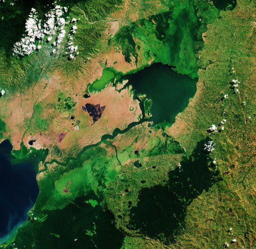 Image:
World Wetlands Day is celebrated internationally each year on 2 February. It marks the anniversary of the signing of the Convention on Wetlands of International Importance, known as the Ramsar Convention, in Ramsar, Iran, on 2 February 1971.
World Wetlands Day raises global awareness about the vital role of wetlands for our planet, paying particular attention to wetland biodiversity.
This Copernicus Sentinel-2 image takes us over Lake George, in western Uganda. In 1988, Lake George was designated as Uganda’s first Ramsar site, given its importance as a centre for biological diversity.
This equatorial lake covers an area of around 250 sq km and has an average depth of around 2.4 metres. Lake George is fed by a complex system of rivers and streams originating from the Rwenzori mountains – supplying a system of permanent swamps surrounding the lake.
A dense fringe of wetland grass, visible in bright green, can be seen around the edges of the lake in the centre of the image.
The wetlands provide a natural living space for a number of mammals including elephants, hippopotamus and antelope. They also provide a habitat for over 150 species of birds including several rare species such as the saddle-billed stork.
Seen from above, the waters of Lake George appear green as a result of the thick concentration of blue-green algae. Metal pollution, mine seepage and agricultural runoff has caused serious pollution to the lake’s waters and are severely impacting the lake’s health.
Lake George drains through the Kazinga Channel in the image’s centre. The wide, 32km long channel connects Lake George with Lake Edward, which lies on the border between Uganda and the Democratic Republic of the Congo.
The Kazinga Channel flows through the Queen Elizabeth National Park. The almost 2000 sq km park is known for its wildlife including the African buffalo and the Nile crocodile.
The park is also famous for its volcanic features, including volcanic cones and deep craters which can be seen dotted around the image. Many contain crater lakes, including the Katwe crater lake, whose salt deposits have been mined for centuries.
Sentinel-2 is a two-satellite mission to supply the coverage and data delivery needed for Europe’s Copernicus programme. The mission’s frequent revisits over the same area and high spatial resolution allow changes in inland water bodies to be closely monitored.
This image is also featured on the Earth from Space video programme.
Earth from Space: Lake George
31.1.2020 10:00 ESA Observing the Earth Video:
00:03:07
Video:
00:03:07
Ahead of World Wetlands Day, celebrated internationally each year on 2 February, this week's edition of the Earth from Space programme features a Copernicus Sentinel-2 image over Lake George in western Uganda. In 1988, Lake George was designated as Uganda’s first site under the Ramsar Convention - an international treaty for the conservation and sustainable use of wetlands.
See also Lake George, Uganda to download the image.
Earth from Space: Lake George
31.1.2020 10:00 ESA Observing the Earth
Video:
00:03:07
Ahead of World Wetlands Day, celebrated internationally each year on 2 February, this week's edition of the Earth from Space programme features a Copernicus Sentinel-2 image over Lake George in western Uganda. In 1988, Lake George was designated as Uganda’s first site under the Ramsar Convention - an international treaty for the conservation and sustainable use of wetlands.
See also Lake George, Uganda to download the image.
Aplikace mapující šíření koronaviru
31.1.2020 9:22 ARCDATAKoronavirus 2019-nCoV se z města Wuhan rozšířil již téměř do všech čínských provincií a překročil i čínské hranice. Byl identifikován u nemocných nejen v Jihovýchodní Asii, ale několik případů je již také v Evropě nebo Severní Americe.
Aktuální situaci mapuje aplikace vytvořená v prostředí Operations Dashboard for ArcGIS, kterou připravilo Centrum pro systémové vědy a inženýrství (CSSE) na univerzitě Johnse Hopkinse. Data aplikace čerpá hned z několika zdrojů a jsou pravidelně aktualizována. Více informací o aplikaci a zdrojích dat naleznete v této tiskové zprávě.

Introducing the Mesa® 3 Rugged Tablet Running Android™ by Juniper Systems
31.1.2020 9:00 GISCafe.com Webcasts-Webinars January 29, 2020 -- Logan, UT – Juniper Systems, Inc. is excited to announce the release of the Mesa 3 Rugged Tablet running on the …Aktualizace datového skladu ÚAP
31.1.2020 7:30 Ústecký krajUpozorňujeme uživatele Geoportálu územně analytických podkladů, že v týdnech od 27.1.2020 do 7.2.2020 bude probíhat úprava funkčních komponent geoportálu v souvislosti s přechodem na novou verzi datového modelu. V tomto termínu nebude funkční výdej dat.
Mapa radonového indexu ČR 1 : 50 000 (GEOČR50)
31.1.2020 1:00 Cenia - Katalog metadat ČR - INSPIRE ArcGIS Server služba zobrazuje výsledky mapování radonového indexu na území České republiky v měřítku 1 : 50 000.Nový dotační program Ministerstva zahraničních věcí ČR
31.1.2020 0:00 Geografický ústav MUDne 6. ledna vyhlásilo Ministerstvo zahraničních věcí ČR dotační program Posilování kapacit veřejných vysokých škol v rozvojových zemích na podporu realizace projektů v těchto zemích: Bosna a Hercegovina, Etiopie, Gruzie, Kambodža, Moldavsko, Zambie a Ukrajina.
Termín pro předkládání žádostí je stanoven na 31. leden 2020, 14 hodin.
Aktivity podpořené v rámci programu zahrnují zejména odborné výměny pedagogů z českých a partnerských veřejných vysokých škol, realizaci společných pedagogických aktivit v rámci meziuniverzitní spolupráce, realizaci specializovaných krátkodobých studijních pobytů učitelů i studentů z rozvojových zemí na českých veřejných vysokých školách, včetně předávání českého know-how v oblasti managementu vysokého školství či v odborné publikační činnosti, apod.
Součástí programu je také podpora navazování nových vztahů mezi českými veřejnými vysokými školami a veřejnými vysokými školami v rozvojových zemích.
Detailní informace - https://www.mzv.cz/jnp/cz/zahranicni_vztahy/rozvojova_spoluprace/aktualne/posilovani_kapacit_verejnych_vysokych.html
Výběrové řízení na jazykové kurzy a studijní pobyty v Maďarsku
31.1.2020 0:00 Geografický ústav MUBylo vypsáno dodatečné výběrové řízení na neobsazená místa na letních jazykových kurzech a na studijní pobyty pro studenty BSP, MSP a DSP v Maďarsku.
Termín odevzdání přihlášek je 31. ledna 2020 do 12:00 hodin.
Detailní informace - https://www.dzs.cz/file/8611/MA%C4%8EARSKO%20VR_AIA_19_aktualizovan%C3%BD.pdf
Spoločné vyhlásenie stavovských a odborných organizácií k PÚ
30.1.2020 23:00 Komora geodetů a kartografů SRUSGIF Accredits New Universities' GEOINT Programs
30.1.2020 21:38 GISCafe.com Webcasts-Webinars Johns Hopkins University and Saint Louis University added to the Foundation’s growing Collegiate Accreditation Program. The University of …Kongsberg Geospatial and MartinUAV partner to provide real-time ISR Drone Solutions for the Canadian defence and security market
30.1.2020 17:22 GISCafe.com Webcasts-Webinars Combining the real-time Kongsberg UAV mission management system with the MartinUAV V-BatTM long endurance VTOL aircraft provides an end-to-end …EagleView Launches EagleView Works™, An All-in-One Sales Assistant App to Help Contractors Win More Business
30.1.2020 17:22 GISCafe.com Webcasts-Webinars EagleView Works™ enables roofing contractors to estimate, quote and close business fasterBELLEVUE, Wash., Jan. 30, 2020 — (PRNewswire) …
Renoworks Enters into Agreement with EagleView to Intregrate EagleView Property Measurements into Renoworks FastTrack Platform
30.1.2020 17:22 GISCafe.com Webcasts-Webinars CALGARY, Jan. 30, 2020 — (PRNewswire) — Renoworks Software Inc. (TSXV: RW) ("Renoworks"), the leading end-to-end visualization …Inpixon Releases New Features for Indoor Mapping Platform
30.1.2020 17:22 GISCafe.com Webcasts-Webinars Enhances Map Creation and Management; Extends Outdoor-Indoor Mapping Capabilities to iOS, Android and Web AppsPALO ALTO, Calif. and TORONTO, Jan. …
DroneUp Launches Airspace Planner with Native LAANC Integration
30.1.2020 11:25 GISCafe.com Webcasts-Webinars Virginia Beach, VA (January 28, 2020) -- DroneUp, LLC, an end-to-end drone pilot service provider for aerial data collection, is pleased to announce …500 let od první cesty kolem světa
30.1.2020 7:00 Česká asociace pro geoinformace Institut Cervantes v Praze zve na přednášku věnovanou první cestě kolem světa, kterou uskutečnili mořeplavci Magalh?es a Elcano a jejíž 500. výročí si tímto připomínáme. Přednáška se bude konat online, a to úterý 1. prosince od 18:00 na následujícím odkazu: https://zoom.us/j/93219549496?pwd=enJkR1MzaU9JVUxZVk9aTjhpZklUUT09Se svými příspěvky vystoupí historikové
Swiss Air-Rescue Rega Deploys Hexagon’s Computer-Aided Dispatch Solution
30.1.2020 2:00 Hexagon Safety & Infrastructure Hosted, state-of-the-art CAD system delivers modern, comprehensive solution with Rescuetrack integrationSwiss Air-Rescue Rega Deploys Hexagon’s Computer-Aided Dispatch Solution
30.1.2020 2:00 Hexagon Safety & InfrastructureSwiss Air-Rescue Rega Deploys Hexagon’s Computer-Aided Dispatch Solution
30.1.2020 2:00 Hexagon Safety & Infrastructure Hosted, state-of-the-art CAD system delivers modern, comprehensive solution with Rescuetrack integrationSkyfront partners with Silvus Technologies to provide long-range Unmanned Aerial Vehicles for BVLOS applications
30.1.2020 0:16 GISCafe.com Webcasts-Webinars MENLO PARK, Calif., Jan. 29, 2020 — (PRNewswire) — Skyfront, the leading provider of hybrid-electric Unmanned Aerial Vehicles (UAVs), …Multiple Faculty Positions in GIS, CyberGIS, and Geospatial Data Science at UIUC
29.1.2020 21:54 UIUC is developing several exciting education and research programs on cyberGIS and geospatial data science, and thus recruiting multiple faculty positions in GIS, CyberGIS, and Geospatial Data Science: http://go.illinois.edu/CyberGIS_geospatial_opportunities. Application deadline is February 17, 2020.FYI — Post-doc in Mobility Information Engineering
29.1.2020 21:44 Post-doc in Mobility Information Engineering 100%, Zurich, temporary https://www.jobs.ethz.ch/job/view/JOPG_ethz_7R9Rl0z6QH6GC0M9Cv The Institute of Cartography and Geoinformation is looking for a highly motivated post-doctoral candidate in the area of Mobility Information Engineering at the Chair of Geoinformation Engineering (www.gis.ethz.ch), starting at the earliest possible date. Job description The main objective of this Post-doc position is the development, implementation […]Open position at Aalto University in Helsinki: Tenure Track Assistant Professor in Geoinformation Technology
29.1.2020 21:39 Open position at Aalto University in Finland: Tenure Track Assistant Professor in Geoinformation Technology, https://www.aalto.fi/en/open-positions/tenure-track-assistant-professor-in-geoinformation-technologyTenured Professor in Geographic Information Science and Dangermond Endowed Chair Position – UC Santa Barbara
29.1.2020 21:37 Tenured Faculty Position Geographic Information Science (GIScience) – Department of Geography The University of California, Santa Barbara, Department of Geography invites applications for the Jack and Laura Dangermond Endowed Chair in Geography. This will be a Tenured faculty position at the level of Associate or Full Professor in Geographic Information Science, with an anticipated start […]Postdoctoral Scholar in Geographic Visualization and Spatial Cognition
29.1.2020 21:36 Applications are still accepted for a postdoctoral scholar position in Geographic Visualization and Spatial Cognition at the UCSB Department of Geography.The postdoc will be engaged in an NSF funded project entitled: “Visualizing Motion: A Framework for the Cartography of Movement”. The project aims to develop and evaluate cartographic theories and tools to understand how humans perceive […]TomTom Traffic Index: Global Traffic Congestion Up as Bengaluru takes Crown of ‘World’s Most Traffic Congested City’
29.1.2020 17:28 GISCafe.com Webcasts-Webinars Ninth edition of the annual TomTom Traffic Index provides detailed insights on live and historic road congestion levels in cities around the …Hexagon Strengthens HxGN Content Program With Acquisition of COWI's Mapping Business
29.1.2020 17:28 GISCafe.com Webcasts-Webinars NACKA STRAND, Sweden, Jan. 29, 2020 — (PRNewswire) — Hexagon AB, a global leader in sensor, software and autonomous solutions, today …Textron Reports Fourth Quarter 2019 Results; Announces 2020 Financial Outlook
29.1.2020 17:28 GISCafe.com Webcasts-Webinars Revenue growth of $285 million, up 7.6% from prior yearThe new Citation Longitude enters service with 13 aircraft deliveries in the quarter
EPS …
CoreLogic Natural Hazard Report Reveals Serious Delinquency Rates Tripled in Recent Disaster-affected Regions
29.1.2020 17:28 GISCafe.com Webcasts-Webinars Annual natural hazard summary examines how previous disasters are impacting today’s micro economies; Looks at the catastrophe and weather events of …Carlson Software Names Sandor Vegh Regional Sales Director for Central Europe
29.1.2020 15:22 Carlson Software MAYSVILLE, Kentucky, U.S.A. (January, 2020) – Carlson Software recently named Hungarian native Sandor Vegh, P.S., as its Regional Sales Director for its Land Development Division in Central Europe. The countries he will be covering include Hungary, the Czech Republic, Austria, Germany, and Bulgaria. While Vegh will remain based in Columbus, Ohio, he is both close […]MAPPS Presents the 2019 Geospatial Products and Services Excellence Awards
29.1.2020 12:20 GISCafe.com Webcasts-Webinars Forest Hill, MD (January 2020) -- MAPPS honored members with the 2019 Geospatial Excellence Awards as part of their …Celofiremní školení v hotelu Medlov na Vysočině
29.1.2020 10:38 Hrdlička Letošní školení v rámci firem Hrdlička Group proběhlo v zasněžené oblasti..HRDLIČKA spol. s r.o. - Celofiremní školení v hotelu Medlov na Vysočině
29.1.2020 10:38 Hrdlička Letošní školení v rámci firem Hrdlička Group proběhlo v zasněžené oblasti..GEOINT 2020 Registration and Housing Now Open
29.1.2020 10:00 GISCafe.com Webcasts-Webinars Leading intelligence conference to offer countless opportunities to learn and exchange ideasHerndon, Virginia (January 28, 2020) …
The Road Asset Management for the Campania Region
29.1.2020 9:49 GISCafe.com Webcasts-Webinars 28 January, 2020, Bologna Italy–SITECO Infomatica SRL together with Sina, wins the tender awarded by ACaMIR. At the end of the …
Pobočka Havlíčkův Brod pořádá Den otevřených dveří
29.1.2020 0:00 Státní pozemkový úřad Trápí vás současné problémy s vodou v krajině? Potřebujete obnovit cesty nebo efektivně navrhnout nové? Chcete znát možnosti boje s erozí zemědělské půdy nebo máte v katastru analogovou mapu či grafické příděly?Řešením mohou být pozemkové úpravy.
Pozemkové úpravy a verejné politiky
28.1.2020 22:22 Komora pozemkových úprav SR
Verejná politika je v tom najširšom ponímaní definovaná a vnímaná ako množina navzájom súvisiacich rozhodnutí, na ktoré pôsobili mnohé okolnosti, ako aj osobné, skupinové či organizačné vplyvy - je nutné ich poznať a vedieť využívať v rámci nášho právneho systému....
Pozemkové úpravy a verejné politiky
28.1.2020 22:22 Komora pozemkových úprav SRVerejná politika je v tom najširšom ponímaní definovaná a vnímaná ako množina navzájom súvisiacich rozhodnutí, na ktoré pôsobili mnohé okolnosti, ako aj osobné, skupinové či organizačné vplyvy. Vládnutie, správa vecí verejných, riadenie štátu sa nevyhnú takýmto vplyvom a preto je nutné ich...
S&P CoreLogic Case-Shiller Index Continues Upward Trend For Annual Home Price Gains
28.1.2020 22:14 GISCafe.com Webcasts-Webinars NEW YORK, Jan. 28, 2020 — (PRNewswire) — S&P Dow Jones Indices today released the latest results for the S&P CoreLogic …Seminář Geodézie ve stavebnictví a průmyslu 2020
28.1.2020 19:19 ZeměměřičSeminář Geodézie ve stavebnictví a průmyslu je součástí doprovodného programu Mezinárodního stavebního veletrhu v Brně. Akce se koná ve čtvrtek 27. února 2020 v Brně od 9:30 hod. Akce je zařazena do programu celoživotního vzdělávání členů ČKAIT a ohodnocena 1 kreditním bodem. 1. BLOK 9:30 – 11:00 Radomír Havlíček (Správa železnic, státní organizace): Digitalizace prostorových informací železniční sítě z pohledu hlavního […]
The post Seminář Geodézie ve stavebnictví a průmyslu 2020 appeared first on Zeměměřič.
Unacast Partners with Mapidea to Deliver Geospatial Data Offerings
28.1.2020 16:50 GISCafe.com Webcasts-Webinars Unacast's partnership with Mapidea will allow a wider group of big name brands to utilize location data.NEW YORK, Jan. 28, 2020 — (PRNewswire) …
HRDLIČKA spol. s r.o. - 1. díl o službě UtilityReport je na světě a 2. díl se připravuje
28.1.2020 16:33 Hrdlička V 1. díle Vám ukážeme, co vše se může stát, pokud si včas nezjistíte, jaké sítě vedou na vašem pozemku před zahájením stavby.1. díl o službě UtilityReport je na světě a 2. díl se připravuje
28.1.2020 16:33 Hrdlička V 1. díle Vám ukážeme, co vše se může stát, pokud si včas nezjistíte, jaké sítě vedou na vašem pozemku před zahájením stavby.HRDLIČKA spol. s r.o. - Přinášíme Vám 2. díl o službě UtilityReport
28.1.2020 16:33 Hrdlička Ve 2. díle Vám ukážeme, jak si lze online ulehčit práci s hromadným podáním žádosti.Přinášíme Vám 2. díl o službě UtilityReport
28.1.2020 16:33 Hrdlička Ve 2. díle Vám ukážeme, jak si lze online ulehčit práci s hromadným podáním žádosti.Sentinel-6 satellite renamed in honour of renowned US scientist
28.1.2020 15:20 ESA Observing the Earth
ESA, NASA, the European Commission, the European Organisation for the Exploitation of Meteorological Satellites (EUMETSAT) and the National Oceanic and Atmospheric Administration (NOAA) have renamed the upcoming Sentinel-6A satellite after Earth scientist Dr. Michael H. Freilich.
Sentinel-6 satellite renamed in honour of renowned US scientist
28.1.2020 15:20 ESA Observing the Earth
ESA, NASA, the European Commission, the European Organisation for the Exploitation of Meteorological Satellites (EUMETSAT) and the National Oceanic and Atmospheric Administration (NOAA) have renamed the upcoming Sentinel-6A satellite after Earth scientist Dr Michael H. Freilich.
‘I am a true believer in the European project’ - Carlo des Dorides talks about his time at GSA
28.1.2020 14:19 European GNSS Agency
Carlo des Dorides took up his position as executive director of the European GNSS Agency (GSA) on February 1, 2011. In the nine years since then, the Galileo programme has progressed from a project on paper to an operational programme with over a billion users around the globe. As his term at the helm of the Agency draws to an end, the GSA executive director looks back at the successes and challenges of the past nine years and speaks about his hopes for the future.
During your nine years at the head of the GSA there have been significant advances in the European GNSS programme. What do you see as the greatest achievement during your term?
When I first took up my position as executive director of the GSA, the Galileo programme only existed on paper and EGNOS had yet to be certified for use in civil aviation. Since then, we have achieved the remarkable figures of over 1 billion Galileo-enabled smartphones on the market and EGNOS present at more than 350 airports in Europe. These figures represent the culmination of the two programmes, but they also represent a remarkable path. On one hand, we built a performing system for both Galileo and EGNOS. But having a performing system is not enough - you also need to have the confidence of users. The GSA played a crucial role in building this confidence.
EGNOS is the first pan-European infrastructure for civil aviation, and in offering it to the market we were faced with many questions. There were questions about certification, about the liability chain, about the updating of avionics. The GSA worked consistently with all stakeholders and brought all of these elements together, and the result is that we now have EGNOS present at so many airports. After nine years of hard work, the figures bear testament to the fact that we have truly created a success story.
As with any venture on this scale, there have been ups and downs in building the European GNSS over the years. What have been the greatest challenges, and how were they overcome?
One difficult decision that we had to face was the decision to take over operational management of the Galileo programme in January 2017. Why was this difficult? Well, there were diverging views about operational readiness, and different assessments of the risks involved. Even though we had declared Initial Services in December 2016, the system was not complete at the time. In a sense, we were taking the wheel of a car that had not yet been fully built, which was not an easy thing to do. At the same time, the GSA itself was not fully formed – it was still a house under construction. To continue with the car analogy, we were a skilled driver, but still a young and untested driver. It was a challenge to manage this uncertainty while still building the system.
Another difficult choice was the decision to declare Initial Services, as this meant that there was now greater public scrutiny of the programme in what was essentially a period of testing and fine-tuning in preparation for the launch of Full Operating Capability. This was a blessing and a curse – while the programme’s successes were celebrated, all technical glitches were very much in the public eye. This was the case with the technical incident last year that resulted in a temporary interruption of the Galileo signal. While this incident was a setback, we learned valuable lessons and are stronger as a result.
Another challenge was when the GSA moved to Prague. At the beginning it was difficult to build the team and to attract the right profiles, as there was uncertainty about the future of the GSA and people didn’t know what to expect in Prague. A mere nine years later the Agency has grown tremendously, both in terms of staff numbers and in prestige, and Prague is one of the top-rated European capitals for quality of life. Now that GSA is expanding into the European Union Agency for the Space Programme, I don’t anticipate any problems with our capacity to attract talented professionals.

During your term, the GSA managed to bring Galileo to over 1 bln smartphones, moving the programme from paper to space and back to Earth to devices and users, what triggered this progress?
In achieving this milestone, the work of the Agency in liaising with user communities has been of fundamental importance. Our constant interaction with users through our User Consultation Platforms has given us a unique understanding of the dynamics of the GNSS market and of the needs of the various user segments. We have also compiled, in alternate years, GNSS Market Reports and GNSS User Technology Reports, which has deepened our understanding of market needs. This understanding has allowed us to effectively meet these needs – and the market has been quick to respond. The work of our Market Development Department has been important in this regard, thanks to their ongoing interaction with all the market segments.
We have also been active in communicating, both to industry and to the general public, about the benefits that Galileo offers in terms of increased accuracy, availability and robustness of the positioning, navigation and timing signal. Manufacturers have been quick to understand these benefits and have been eager to pass them on to their customers. These customers, in turn, are becoming increasingly aware of the accuracy and availability gains that Galileo offers, and this is reflected in the 1 billion smartphone milestone. This was a remarkable achievement for the Galileo programme, and the fact that it occurred in the same week that we celebrated the 15th anniversary of the Agency made it especially gratifying.
You have been leading one of the fastest growing European agencies, linking space to user needs, with assets and teams spread across Europe. What are the key elements of your leadership?
Building the right team for the job was key to my success at the head of the GSA and key to the success of the Agency in building Galileo and EGNOS. In my position as GSA executive director I had to wear many hats to understand and respond to the needs of the Agency and its growing team, along with our stakeholders and user communities. As a leader, you are responsible for guiding the team and creating the right mind-set among the team members. You need to lead by example, but you also need to play as a team member, know when to take the stage and when let others shine, and be ready to serve and do what is required of you. I am proud of the team that we have built at the GSA. I believe that GSA has a key role to play in making the EU Space programme grow and thrive both at the European and Global level.
On a more personal level, when you look back at your term as the executive director of the GSA, what gives you the most pride or satisfaction?
There are a number of things that come to mind when I look back at my term at the GSA. First of all, by helping to establish the Galileo programme, I feel that I have made a contribution to building Europe. I am a true believer in the European project. My position at the GSA gave me a wonderful opportunity to work on a concrete project that shows what the EU can achieve by working together. The European space programmes would not have been possible for any individual Member State to accomplish alone – it was only by coming together as Europeans that this became possible.
Secondly, I am proud to have helped create a future for all the staff that believed in our project and put their trust in me and in the Agency. Thanks to their dedication, the future of the Agency looks bright. I was approached by an Agency employee recently who told me that they had really enjoyed working at the GSA because of the positive working atmosphere that exists here, based on a common motivation and shared values. It takes time to build this, but it is fundamentally important. Building the GSA team was difficult in the beginning but it was an important achievement and it is one of which I am particularly proud.
What does the future look like for the European space programme and for the GSA, and do you have any ‘words of wisdom’ for your successor?
The future looks promising, both for the EU Space Programme and for the GSA. The recently approved Regulation on the EU Space Programme and on setting up the European Union Agency for the Space Programme (EUSPA) paves the way for the expansion of the programme, with an increased budget and expanded responsibilities. The approval of the Regulation shows that we have earned the confidence of the Member States. They can see that the space programme is creating economic opportunities and jobs, and understand the benefits that it offers for their citizens and for European growth.
In terms of ‘words of wisdom’ for my successor – I would just say that it is important to embrace change. We live in a dynamic world and change is an important part of our daily work. That said; change should be approached with caution. What we have built here at the GSA is the result of maturity gained over the years. I would advise that change should be preceded by careful listening to all stakeholders and careful consideration of all possible outcomes. Otherwise we could stand to lose what we have built.
Market understands value of dual frequency
28.1.2020 11:32 European GNSS Agency
Chip manufacturers are very aware of the opportunities that dual frequency offers and, correspondingly, the market has witnessed the launch of a range of mass-market dual-frequency chips targeted at various applications. In turn, smartphone manufacturers also understand the benefits that these chips provide in terms of positioning accuracy for location based services and are eager to pass on these benefits to their users.
To date, there are 41 smartphone models on the market, from 10 manufacturers, offering dual-frequency capability. One of the most recent launches by a major manufacturer was the Galaxy Note10 and Galaxy Note10+ from Samsung Electronics, which hit the market in the second half of last year. Fitted with the Broadcom BCM47755 chip, these smartphones are the first from the South Korean multinational to provide dual-frequency GNSS capability.
Users of these and other dual-frequency smartphones are able to benefit from the increased accuracy and robustness of the GNSS signal, particularly in urban environments, as dual-frequency phones are more resistant to multipath errors. Developers too are able to leverage the enhanced accuracy offered by this dual-frequency capability to create new applications requiring high accuracy, robust positioning. Check on the UseGalileo site, to see if your smartphone has dual-frequency capability.
Read this: MyGalileoApp – an ecosystem of innovation
The growing number of dual-frequency smartphones on the market clearly shows that the major electronics manufacturers understand the opportunities that this capability provides in terms of enabling a new generation of location based services. But there is one area in particular that will spark growing demand for dual frequency.
Dual-frequency – Galileo leads the way
According to the latest GNSS Market Report, published in October last year, for the 5G market in particular, the availability of accurate, cost effective and robust, dual-frequency GNSS systems will be critical in providing business opportunities. With the increased rollout of 5G internationally in the coming years, dual-frequency capability will be a key factor and we are likely to see an even greater number of compatible devices on the market.
And this: EU Space Week 2019: Investors meet innovation
This is good news for the Galileo system – dual-frequency capacity is a key Galileo differentiator, as the Galileo constellation has the highest number of dual-frequency satellites of any GNSS system. “Since the first dual-frequency GNSS smartphone hit the market back in June 2018, the trend has been towards increased implementation of dual-frequency capability in consumer platforms, allowing them to improve their location performance,” said European GNSS Agency (GSA) Head of Market Development Fiammetta Diani, adding that Galileo stands ready to support this trend.
Why is it important?
Dual-frequency capability means that the GNSS receivers are able to receive two GNSS signals at different frequencies from a satellite. In the case of Galileo, these frequencies are E1 and E5a. Dual frequency provides increased reliability to users – if one of the frequency bands fails, the other can be used as backup.
Other advantages of dual-frequency capability include a reduced signal acquisition time and improved accuracy of positioning and timing. Dual frequency also reduces problems caused by obstructions such as buildings and other obstacles, thanks to the fact that the L5/E5a signals are lower in frequency, making them are less prone to multipath interference errors.
Media note: This feature can be republished without charge provided the European GNSS Agency (GSA) is acknowledged as the source at the top or the bottom of the story. You must request permission before you use any of the photographs on the site. If you republish, we would be grateful if you could link back to the GSA website (http://www.gsa.europa.eu).
Hexagon Unveils M.App X 2020 for Enhanced Imagery Intelligence
28.1.2020 10:27 GISCafe.com Webcasts-Webinars Latest release delivers 3D display modes and accelerated visualization and analysis27 January 2020 -- (Norcross, GA. USA) -- Hexagon’s …
Oznámení o vyhlášení výběrového řízení
28.1.2020 9:15 ČÚZK - předpisy a opatření Katastrální úřad pro Královéhradecký kraj zveřejnil novou aktualitu: Oznámení o vyhlášení výběrového řízení na pracovní místo - investiční referent v oddělení hospodářské správy kanceláře ředitele Katastrálního úřadu pro Královéhradecký krajOznámení o vyhlášení výběrového řízení
28.1.2020 9:15 ČÚZK - předpisy a opatření Katastrální úřad pro Královéhradecký kraj zveřejnil novou aktualitu: Oznámení o vyhlášení výběrového řízení na pracovní místo - investiční referent v oddělení hospodářské správy kanceláře ředitele Katastrálního úřadu pro Královéhradecký krajOznámení o vyhlášení výběrového řízení
28.1.2020 9:15 ČÚZK - předpisy a opatření Katastrální úřad pro Královéhradecký kraj zveřejnil novou aktualitu: Oznámení o vyhlášení výběrového řízení na pracovní místo - investiční referent v oddělení hospodářské správy kanceláře ředitele Katastrálního úřadu pro Královéhradecký krajOznámení o vyhlášení výběrového řízení
28.1.2020 9:15 ČÚZK /Urady/Katastralni-urady/Katastralni-urady/Katastralni-urad-pro-Kralovehradecky-kraj/O-uradu/Aktuality/Oznameni-o-vyhlaseni-vyberoveho-rizeni-(2)Investiční referent v oddělení hospodářské správy kanceláře ředitele
28.1.2020 9:04 ČÚZK - volná místa Katastrální úřad pro Královéhradecký kraj - odbor hospodářské správy vypisuje výběrové řízení na místo Investiční referent v oddělení hospodářské správy kanceláře řediteleInvestiční referent v oddělení hospodářské správy kanceláře ředitele
28.1.2020 9:04 ČÚZK /Urady/Katastralni-urady/Katastralni-urady/Katastralni-urad-pro-Kralovehradecky-kraj/Volna-mista/Investicni-referent-v-oddeleni-hospodarske-spravyInvestiční referent v oddělení hospodářské správy kanceláře ředitele
28.1.2020 9:04 ČÚZK - předpisy a opatření Katastrální úřad pro Královéhradecký kraj - odbor hospodářské správyvypisuje výběrové řízení na místo
Investiční referent v oddělení hospodářské správy kanceláře ředitele
Nový C předmět Studentská odborná soutěž v GI
28.1.2020 8:46 Katedra geoinformatiky UP OlomoucOd letního semestru ak. roku 2019/20 je nově možné si zapisovat nový C předmět KGI/SOUGI Studentská odborná soutěž v GI. Popis předmětu, požadavky, motivace atd. je ve STAGu. Předmět má založen i MOODLE kurz.
The post Nový C předmět Studentská odborná soutěž v GI appeared first on Katedra geoinformatiky.
Vyjmenované zdroje znečištění ovzduší
28.1.2020 8:45 Středočeský kraj Nová mapová aplikace Vyjmenované zdroje znečištění ovzduší s povolením provozu zobrazuje stacionární zdroje znečišťování ovzduší na území Středočeského kraje, ke kterým vydal Krajský úřad Středočeského kraje povolení provozu podle zákona č. 201/2012 Sb., o ochraně ovzduší. Aplikace nabízí nepřeberné množství informací, jako např. název a kategorie zdroje znečištění dle přílohy č. 2 zákona č. 201/2012 Sb., o ochraně ovzduší, název provozovatele, kdo a kdy žádost vyřizoval, pod jakým číslem jednacím atd. U provozoven, v nichž se nachází více zdrojů znečišťování ovzduší, je vždy uveden kód hlavního zdroje provozovny. Při realizaci této aplikace byla snaha naplnit dva cíle. První cíl se zaměřuje na informovanost a osvětu veřejnosti v otázkách ochrany ovzduší, proto je i aplikace součástí Akčního plánu k implementaci Programu zlepšování kvality ovzduší Zóna Střední Čechy – CZ02. Druhým cílem je zprostředkovat zaměstnancům krajského úřadu odkazy na digitalizované dokumenty Rozhodnutí o povolení provozu k jednotlivým zdrojům. Aplikaci připravil Odbor životního prostředí a zemědělství ve spolupráci s Odborem informatiky / GIS.Kratos XQ-58A Valkyrie Flies over Yuma in Fourth Successful Flight
27.1.2020 19:18 GISCafe.com Webcasts-Webinars SAN DIEGO, Jan. 27, 2020 (GLOBE NEWSWIRE) -- Kratos Defense & Security Solutions, Inc. (NASDAQ:KTOS), a leading National Security Solutions …48-Foot Wingspan Autonomous Cargo Delivery Drone to be Unveiled at the 2020 Farnborough International Airshow
27.1.2020 19:18 GISCafe.com Webcasts-Webinars Silent Arrow® GD-2000 WB (wide-body) launched as second customer-driven aircraft in Yates Electrospace Corporation's heavy payload UAS product …AiRXOS Supercharges Ecosystem Partners to Accelerate Advanced Unmanned Operations – Empowering Customers with End-to-End Unmanned Aircraft System Solution
27.1.2020 19:18 GISCafe.com Webcasts-Webinars The AiRXOS Air MobilityTM Platform adds 11 new partners – industry-leading unmanned solutions, applications, service and business providers to …Woolpert and Optimal GEO JV Wins MAPPS Grand Award for Lidar Collection After Hurricane Maria
27.1.2020 19:18 GISCafe.com Webcasts-Webinars Woolpert and Optimal GEO were presented with the MAPPS Award for Data Acquisition & Processing and the MAPPS Grand Award for their "Hurricane Maria: …CryoSat sheds new light on Antarctica’s biggest glacier
27.1.2020 17:00 ESA Observing the Earth
Ice loss from Pine Island Glacier has contributed more to sea-level rise over the past four decades than any other glacier in Antarctica. However, the way this huge glacier is thinning is complex, leading to uncertainty about how it is likely to raise sea level in the future. Thanks to ESA’s CryoSat mission, scientists have now been able to shed new light on these complex patterns of ice loss.
CryoSat sheds new light on ice loss from Antarctica’s biggest glacier
27.1.2020 17:00 ESA Observing the Earth
Ice loss from Pine Island Glacier has contributed more to sea-level rise over the past four decades than any other glacier in Antarctica. However, the way this huge glacier is thinning is complex, leading to uncertainty about how it is likely to raise sea level in the future. Thanks to ESA’s CryoSat mission, scientists have now been able to shed new light on these complex patterns of ice loss.
Komplexní pozemková úprava Adršpach
27.1.2020 15:13 Hrdlička Naše společnost zahájila geodetické práce v okolí Adršpašsko-teplických skal...HRDLIČKA spol. s r.o. - Komplexní pozemková úprava Adršpach
27.1.2020 15:13 Hrdlička Naše společnost zahájila geodetické práce v okolí Adršpašsko-teplických skal...Rozpočet úřadu za rok 2020
27.1.2020 11:44 ČÚZK - předpisy a opatření Český úřad zeměměřický a katastrálnívystavuje rozpočet úřadu za rok
2020
Rozpočet úřadu za rok 2020
27.1.2020 11:44 ČÚZK /Urady/Cesky-urad-zememericky-a-katastralni/Rozpocty/Rozpocet-uradu-za-rok-2020Kleos and Geollect sign Channel Partner and Integrator Agreement
27.1.2020 11:11 GISCafe.com Webcasts-Webinars • Kleos’ Scouting Mission data to improve UK based company Geollect’s dark vessel locating capability• Geollect is a leader in …Odborný referent / vrchní referent – obnova katastrálního operátu v oddělení obnovy katastrálního op
27.1.2020 7:02 ČÚZK /Urady/Katastralni-urady/Katastralni-urady/Katastralni-urad-pro-Zlinsky-kraj/Uredni-deska/Oznameni-a-jina-uredni-sdeleni/Volna-mista/DMS/Odborny-referent-vrchni-referent-–-obnova-katastOdborný referent / vrchní referent – obnova katastrálního operátu v oddělení obnovy katastrálního op
27.1.2020 7:02 ČÚZK - volná místa Katastrální úřad pro Zlínský kraj vypisuje výběrové řízení na místo Odborný referent / vrchní referent – obnova katastrálního operátu v oddělení obnovy katastrálního opOdborný referent / vrchní referent – obnova katastrálního operátu v oddělení obnovy katastrálního op
27.1.2020 7:02 ČÚZK - předpisy a opatření Katastrální úřad pro Zlínský krajvypisuje výběrové řízení na místo
Odborný referent / vrchní referent – obnova katastrálního operátu v oddělení obnovy katastrálního operátu Katastrálního úřadu pro Zlínský kraj
Státní mapa 1:5 000
27.1.2020 1:00 Cenia - Katalog metadat ČR - INSPIRE Státní mapa 1:5 000–odvozená, vydávaná postupně od roku 1950, byla zamýšlena jako provizorium. Pro první vydání byl polohopis odvozen z katastrálních map a výškopis z nejvhodnějších existujících podkladů, například z topografických map v systému S-1952, v případě nezbytnosti i z topografických sekcí 3. vojenského mapování. Polohopis zobrazoval sídla, dopravní síť, vodstvo, lesy, správní hranice a značkami místopisné podrobnosti, jako jsou mosty, kříže, sochy, komíny, věže apod., vše v šedé barvě. Výškopis byl znázorněn vrstevnicemi v závislosti na použitých výškopisných podkladech, výškovými kótami a podle potřeby technickým nebo topografickým šrafováním včetně popisu v barvě hnědé. Grafické provedení mapového rámu se v průběhu vydávání map lišilo, u prvního vydání jsou na jednoduchém přímkovém rámu vyznačeny rysky rovinné souřadnicové sítě Křovákova zobrazení v půlkilometrovém intervalu. Až do roku 1990 tyto mapy nebyly určeny veřejnosti, ale směly se používat pouze pro vnitřní potřebu státních orgánů a socialistických organizací. Do produktu jsou zařazovány kromě skenů postupných vydání Státní mapy 1:5 000–odvozené i skeny mladších map neodvozených.Test VÚV dataset
27.1.2020 1:00 Cenia - Katalog metadat ČR - INSPIRE Vrstva obsahuje vymezení chráněných území s vazbou na vodu a je formálně upravena pro potřeby reportingu podle směrnice 2000/60/ES (WFD). Obsažena jsou chráněná území, která nebyla reportována na základě jiné legislativy, tedy Ramsarské mokřady a maloplošná zvláště chráněná území. Prostorová i popisná složka dat byla upravena podle směrných dokumentů a požadavků Evropské komise na reporting Plánů oblastí povodí v roce 2016.Test VÚV WFS
27.1.2020 1:00 Cenia - Katalog metadat ČR - INSPIRE vrstva obsahuje vymezení chráněných území s vazbou na vodu a je formálně upravena pro potřeby reportingu podle směrnice 2000/60/ES (WFD). Obsažena jsou chráněná území, která nebyla reportována na základě jiné legislativy, tedy Ramsarské mokřady a maloplošná zvláště chráněná území. Prostorová i popisná složka dat byla upravena podle směrných dokumentů a požadavků Evropské komise na reporting Plánů oblastí povodí v roce 2016.Lego model ISS (Mezinárodní vesmírné stanice)
26.1.2020 1:30 GeoBusinessFirma Lego vydává v edici Lego Ideas novou sadu, která obsahuje kompletní Mezinárodní vesmírnou stanici včetně takových detailů jako je Space Shuttle. Mezinárodní vesmírná stanice, známější pod zkratkou ISS, je osídlena od listopadu 2000, kdy na stanici vstoupila první stálá posádka. Lego model ISS, který má 864 dílků a cena je 70 dolarů, bude na […]
The post Lego model ISS (Mezinárodní vesmírné stanice) appeared first on GeoBusiness.
Lego model Mezinárodní vesmírné stanice
26.1.2020 1:30 GeoBusinessFirma Lego vydává v edici Lego Ideas novou sadu, která obsahuje kompletní Mezinárodní vesmírnou stanici včetně takových detailů jako je Space Shuttle. Mezinárodní vesmírná stanice, známější pod zkratkou ISS, je osídlena od listopadu 2000, kdy na stanici vstoupila první stálá posádka. Lego model ISS, který má 864 dílků a cena je 70 dolarů, bude na […]
The post Lego model Mezinárodní vesmírné stanice appeared first on GeoBusiness.
Lego model Mezinárodní vesmírné stanice
26.1.2020 1:30 GeoBusiness Firma Lego vydává v edici Lego Ideas novou sadu, která obsahuje kompletní Mezinárodní vesmírnou stanici včetně takových detailů jako je Space Shuttle. Mezinárodní vesmírná stanice, známější pod zkratkou ISS, je osídlena od listopadu 2000, kdy na stanici vstoupila první stálá posádka. Lego model ISS, který má 864 dílků a cena je 70 dolarů, bude na […]VZ: Nadlimitní komplexní pozemkové úpravy v Hřensku
26.1.2020 0:55 ZeměměřičStátní pozemkový úřad vypsal nadlimitní veřejnou zakázku na komplexní pozemkové úpravy v katastrálních územích Janov u Hřenska a Oldřichov nad Ploučnicí. Zadavatel v souladu s ustanovením § 101 zákona, dělí veřejnou zakázku na dvě (2) části, které svým předmětem vymezuje takto: Část 1 – KoPÚ v k.ú. Janov u Hřenska Předmětem plnění veřejné zakázky je zpracování návrhu komplexní pozemkové úpravy (dále jen […]
The post VZ: Nadlimitní komplexní pozemkové úpravy v Hřensku appeared first on Zeměměřič.
Esri Partners with OSI to Provide Advanced GIS Capabilities and Real-Time Monitoring to Utilities
24.1.2020 18:07 GISCafe.com Webcasts-Webinars Customers Will Have Joint Access to the monarch™ Platform and the ArcGIS Utility Network Management ExtensionREDLANDS, Calif. — (BUSINESS …
A Day in the Life of Flirtey: The Future of Delivery (VIDEO)
24.1.2020 18:07 GISCafe.com Webcasts-Webinars RENO, Nev., Jan. 24, 2020 — (PRNewswire) — Flirtey, the industry-leading drone delivery service, released today a rare, inside …Contract secures build of ozone-monitoring Altius satellite
24.1.2020 16:20 ESA Observing the Earth
ESA has awarded a contract to QinetiQ to build Altius. This new mission will deliver profiles of concentrations of stratospheric ozone with high vertical resolution, as well as profiles of other atmospheric trace gases.
Aktualizace dat v mapových aplikacích
24.1.2020 14:05 Jihočeský kraj Data katastru nemovitostí (DKM, KMD, KM-D a ÚKM) byla v mapových aplikacích i výdejním modulu aktualizována k 1. 1. 2020.Informace o výsledcích kontrol dle § 26 zákona č. 255/2012 Sb. za rok 2019
24.1.2020 13:35 ČÚZK - předpisy a opatření Zeměměřický a katastrální inspektorát v Českých Budějovicíchvydává informace o výsledcích kontrol dle § 26 zákona č. 255/2012 Sb. za rok
2019
Jakub Karas se stal tento týden novým prezidentem Aliance pro bezpilotní letecký průmysl
24.1.2020 11:53 UpVisionJakub Karas se stal tento týden novým prezidentem Aliance pro bezpilotní letecký průmysl. Novým prezidentem Aliance pro bezpilotní letecký průmysl se stal Ing. Jakub Karas (UpVision) a novými členy představenstva Ing. Robert Šinkner (TKP geo) a Ing. Vladímír Hůda (EasyMap), kteří byli zvoleni na valné hromadě UAVA tento týden v Plzni. Chystáme v tomto důležitém roce z hlediska […]
The post Jakub Karas se stal tento týden novým prezidentem Aliance pro bezpilotní letecký průmysl appeared first on Upvision.
AGILE PHD SCHOOL aneb jak jsme domluvili Erasmus v Estonsku
24.1.2020 11:18 Katedra geoinformatiky UP OlomoucCo jsou letní školy jistě všichni znáte. I my doktorandi ve složení Kuba Koníček, Markéta Beitlová a Radek Barvíř jsme se na jednu takovou nedávno vypravili. A když už na letní školu, tak poslední listopadový víkend a do mrazivého Estonska ❄️😁 Čekal nás týden v univerzitním městě Tartu zaměřený na časoprostorovou geovizualizaci a rozvoj našich […]
The post AGILE PHD SCHOOL aneb jak jsme domluvili Erasmus v Estonsku appeared first on Katedra geoinformatiky.
AGILE PHD SCHOOLaneb jak jsme domluvili Erasmus v Estonsku
24.1.2020 11:18 Katedra geoinformatiky UP OlomoucCo jsou letní školy jistě všichni znáte. I my doktorandi ve složení Kuba Koníček, Markéta Beitlová a Radek Barvíř jsme se na jednu takovou nedávno vypravili. A když už na letní školu, tak poslední listopadový víkend a do mrazivého Estonska ❄️😁 Čekal nás týden v univerzitním městě Tartu zaměřený na časoprostorovou geovizualizaci a rozvoj našich […]
The post AGILE PHD SCHOOLaneb jak jsme domluvili Erasmus v Estonsku appeared first on Katedra geoinformatiky.
Informace o výsledcích kontrol dle § 26 zákona č. 255/2012 Sb. za rok 2019
24.1.2020 10:43 ČÚZK - předpisy a opatření Český úřad zeměměřický a katastrálníInformace o výsledcích kontrol dle § 26 zákona č. 255/2012 Sb. za rok 2019
2019
GISCafe Industry Predictions 2020 – Part 4 by Susan Smith
24.1.2020 10:15 GISCafe.com Webcasts-WebinarsURISA Announces the Release of the 2nd Edition of The GIS Management Handbook
24.1.2020 10:10 GISCafe.com Webcasts-Webinars Des Plaines, IL (January 23, 2020) -- URISA is pleased to announce the release of the second edition of The GIS Management Handbook. This is a …Earth from Space: Deforestation in Bolivia
24.1.2020 10:00 ESA Observing the Earth Video:
00:03:15
Video:
00:03:15
This week's edition of the Earth from Space programme features a Copernicus Sentinel-2 image over an area in the Santa Cruz Department of Bolivia, where part of the tropical dry forest has been cleared for agricultural use.
See also Deforestation in Bolivia to download the image.
Earth from Space: Deforestation in Bolivia
24.1.2020 10:00 ESA Observing the Earth
Video:
00:03:15
This week's edition of the Earth from Space programme features a Copernicus Sentinel-2 image over an area in the Santa Cruz Department of Bolivia, where part of the tropical dry forest has been cleared for agricultural use.
See also Deforestation in Bolivia to download the image.
This week's edition of the Earth from Space programme features a Copernicus Sentinel-2 image over an area in the Santa Cruz Department of Bolivia, where part of the tropical dry forest has been cleared for agricultural use.
See also Deforestation in Bolivia to download the image.
Earth from Space: Deforestation in Bolivia
24.1.2020 10:00 ESA Observing the Earth
Video:
00:03:15
This week's edition of the Earth from Space programme features a Copernicus Sentinel-2 mage over an area in the Santa Cruz Department of Bolivia, where part of the tropical dry forest has been cleared for agricultural use.
See also Deforestation in Bolivia to download the image.
Deforestation in Bolivia
24.1.2020 10:00 ESA Observing the Earth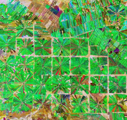 Image:
This Copernicus Sentinel-2 image features an area in the Santa Cruz Department of Bolivia, where part of the tropical dry forest has been cleared for agricultural use.
Since the 1980s, the area has been rapidly deforested owing to a large agricultural development effort where people from the Andean high plains (the Altiplano region) have been relocated to the lowlands of Bolivia.
The relatively flat lowlands and abundant rainfall make this region suitable for farming. In fact, the local climate allows farmers to benefit from two growing seasons. The region has been transformed from dense forest into a patterned expanse of agricultural land. This deforestation method, common in this part of Bolivia, is characterised by the radial patterns that can be seen clearly in the image.
Each patterned field is approximately 20 sq km and each side is around 2.5 km long.
Small settlements can be seen in the centre of each individual field in the image, which typically contain a church, a school and a soccer field. These communities are joined by a road network depicted by the straight lines that bisect the radial fields and connect the adjacent areas.
Meandering streams and rivers can be seen flowing through the fields. The long, thin strips of land in the top right of the image are most likely cultivated soybean fields.
Rainforests worldwide are being destroyed at an alarming rate. This is of great concern as they play an important role in global climate, and are home to a wide variety of plants and animals.
Because of their unique perspective from space, Earth observation satellites are instrumental in providing comprehensive information on the full extent and rate of deforestation, which is particularly useful for monitoring remote areas.
This composite image was created by combing three separate ‘Normalised Difference Vegetation Index’ images from the Copernicus Sentinel-2 mission. The first image, from 8 April 2019, is visible in red; the second from 22 June 2019, can be seen in green; and the third from 5 September 2019 can be seen in blue. The Normalised Difference Vegetation Index is widely used in remote sensing as it gives scientists an accurate measure of healthy and status of plant growth.
This image is also featured on the Earth from Space video programme.